General Plan
Government Code § 65300 requires each county to "adopt a comprehensive long-term general plan for the physical development of the county." Mono County is unique in that the General Plan and Zoning Code have been combined into one document.
The purpose of the Mono County General Plan is to establish policies to guide decisions on future growth, development, and conservation of natural resources in the unincorporated area of the county. The plan reflects community-based planning and includes individual area plans for Mono County communities.
The following summarizes the vision of the Mono County General Plan:
The environmental and economic integrity of Mono County shall be maintained and enhanced through orderly growth, minimizing land use conflicts, supporting local tourist and agricultural based economies, and protecting the scenic, recreational, cultural, and natural resources of the area. The small-town atmosphere, rural- residential character and associated quality of life will be sustained consistent with community plans. Mono County will collaborate with applicable federal, state and local entities in pursuing this vision through citizen-based planning and efficient, coordinated permit processing.
The planning areas of June Lake and Mono Basin also have separately published area or community plans, which are incorporated into the Land Use Element of the General Plan. These documents will be posted below when they are available.
The work upon which this publication is based was funded in part through a grant awarded by the California Strategic Growth Council. Disclaimer: The statements and conclusions of this report are those of Mono County and not necessarily those of the California Strategic Growth Council or of the California Department of Conservation, or its employees. The California Strategic Growth Council and the California Department of Conservation make no warranties, express or implied, and assume no liability for the information contained in the succeeding text.
02-01 Introduction
The purpose of the Land Use Element is to correlate all land use issues into a set of coherent development policies for the private lands in the unincorporated area of the county. The goals, policies, and actions of the element relate directly to other elements and issues addressed in the General Plan. Although all General Plan elements carry equal weight, the Land Use Element is generally considered the most representative of the General Plan, and in practice, is the most visible and often-used element. Mono County's first Land Use Element was adopted in 1968 and last comprehensively updated in 2000, although individual sections have since been updated. This element supersedes and replaces the document as it existed in 2014.
The county Master Environmental Assessment (MEA) summarizes existing land uses in the county, and outlines the plans, policies, and regulations currently affecting land use in the county. The Issues section of this element identifies and analyzes opportunities and constraints that influence the future development potential of the county's unincorporated areas. The Issues section first addresses countywide issues and then focuses on issues that are applicable to individual community areas in the county. The Policy section establishes countywide and community-specific directives to guide growth, development and use of land in the unincorporated area through the year 2035;
Government Code § 65302(a) requires that the Land Use Element designate the proposed general distribution, general location, and extent of land use in the county for housing, business, industry, and open space, including agriculture, natural resources, recreation and enjoyment of scenic beauty, education, public buildings and grounds, solid and liquid waste disposal facilities, and other categories of public and private uses of the land. In addition, the Land Use Element is required to include standards of population density and building intensity recommended for the territory covered by the plan, and to identify areas subject to flooding and areas zoned for timberland production (TPZ lands) and consider the impact of new growth on military readiness activities carried out on military bases, installations when designating land uses for land adjacent to military facilities, or underlying designated military aviation routes and airspace.
Each required issue is addressed in this element, to the extent that it is relevant in this context. Otherwise it is discussed in other elements as follows:
- Distribution of housing, business, and industry (see the Housing and Land Use Sections of the MEA).
- Distribution of open space, including agricultural lands (see the Land Use Section of the MEA).
- Distribution of mineral resources and provisions for their continued availability (see the Mineral Resources Section of the MEA, and the Conservation/Open Space Element, "Mineral Resource Policies”).
- Distribution of recreational facilities and opportunities (see the Outdoor Recreation Section of the MEA, and the Conservation/Open Space Element, "Outdoor Recreation Policies”).
- Location of education facilities (see the Community Services and Facilities Section of the MEA).
- Location of public buildings and grounds (see the Community Services and Facilities Section of the MEA).
- Location of future solid and liquid waste facilities (also see the Community Services and Facilities Section of the MEA, and the Mono County Integrated Waste Management Plan)
- Identification of areas subject to flooding (see the Flood Hazards Section of the MEA, and the Safety Element, "Flood Hazard Policies”).
- Identification of existing Timberland Production Zone (TPZ) lands (currently, there is no TPZ land designated in Mono County).
- Military Readiness (also see the Agency Relationships Section of the MEA).
In addition to the countywide Land Use Element, land use in community areas is governed by Area Plans. Area Plans possess the same regulatory authority as the countywide land use policies, serving to further refine those policies to address the needs of a particular community or area. An Area Plan must be internally consistent with the county General Plan, but need not address all the General Plan issues required by Government Code Section 65302, as long as the county General Plan satisfies those requirements.
Area Plans have been adopted for every major population center in the county with the exception of Paradise. Those policies are included in this Land Use Element, and are considered when reviewing development proposals in those areas. General environmental information for the Area Plans is contained in the county Master Environmental Assessment (MEA).
Specific Plans are intended to function as implementation mechanisms for the General Plan and as a standard-setting mechanism for detailed land use designation, subdivisions, and use permits. A specific plan must be consistent with the General Plan and, once adopted, becomes a part of the General Plan. Mono County currently has a number of adopted Specific Plans:, Bodie RV Park, Crowley Lake Estates, Lakeridge Ranch in Crowley Lake/Hilton Creek, Highlands in June Lake, Mountain Vistas in Chalfant, Rimrock Ranch in Swall Meadows, Rock Creek Canyon and Rock Creek Ranch in Paradise, Sierra Business Park in Long Valley, Tioga Inn in Lee Vining, and White Mountain Estates in Chalfant.
Land use in the area adjacent to public airports is governed by Airport Land Use Plans (ALUPs). An Airport Land Use Plan was adopted in 1986 by the Airport Land Use Commission for the Mammoth June Lake Airport (renamed Mammoth Yosemite Airport). Airport Land Use Plans have been developed for the Lee Vining and Bridgeport (Bryant Field) airports. Land use policies for each of the airports are included in this Element.
02-02 Issues/ Opportunities/Constraints
- Certain areas of the county continue to experience development pressures; Antelope Valley from the Gardnerville/Carson City area, Chalfant from the Bishop area, and the Long Valley communities from the Mammoth area. Although the countywide growth rate over the next 20 years will probably be close to that projected by the State Department of Finance (between .55% and .80% annually), and the unincorporated area will probably continue to house slightly less than 50% of the total county population (42% in 2010), the population distribution in the unincorporated areas may shift over that time frame.
- Many county residents do not work in the community in which they live. Residents in the Antelope Valley commute to work in Bridgeport and in Gardnerville, Minden, and Carson City in Nevada; residents of the Tri-Valley area commute to work in Bishop; and residents of Long Valley, June Lake, and Benton commute to work in Mammoth Lakes. Bridgeport is the only unincorporated community with a large portion of its residents working in the community. The separation between jobs and housing may continue in the future due to the nature of the county's economy and the limited potential for future economic expansion in many areas of the county.
- The expansion of existing communities or the development of new communities is currently limited by land ownership; acquiring the land necessary for development would require working with the USFS or BLM to designate lands for a land trade or purchase and could be a costly and time-consuming process. Acquiring land from LADWP is limited by the City of Los Angeles' charter, which prohibits the selling of water rights on its land. In effect, this means that any land released by LADWP for community development must be served by an existing community water system.
- Land use within the unincorporated area of Mono County is highly constrained by land ownership. Approximately 94% of the land in the county is publicly owned; 88% is federally owned; and the remainder is owned by the State of California, the Los Angeles Department of Water and Power, or Native American tribal groups. The majority of private land within the county is concentrated in community areas, with the remainder dispersed throughout the county in isolated parcels. Within existing community boundaries, some communities have limited land available for additional development; expansion of some communities beyond existing boundaries is limited by the public ownership of surrounding lands. Development of new communities throughout the county is limited by the lack of large concentrations of private lands outside existing communities; those parcels of private land that are large enough for development are in many cases agricultural lands and are not available for development.
- Mono LAFCO policies discourage the designation of land for urban expansion before there is a demonstrated need for such expansion; these policies also promote the expansion of existing communities instead of the development of new communities.
- Land use planning in the county is fragmented due to the pattern of land ownership. The federal land management agencies have planning authority on federal lands; the Town has planning authority for the incorporated area; and state agencies have planning authority on state lands. The County has only limited environmental authority on the federally owned lands managed by the USFS and the BLM; i.e., for minerals development, the County is the lead agency for compliance with the requirements of SMARA (Surface Mining and Reclamation Act). The County has planning authority on LADWP lands and any development on those lands must comply with CEQA and the County's environmental review process. Development on LADWP lands is a key issue, since much of the land that LADWP owns is environmentally sensitive; e.g., wetlands and critical wildlife habitat.
- Land use patterns in the county are influenced by land ownership and topography. Residential and commercial uses are generally concentrated in small communities located in the valleys agricultural and recreational uses are dispersed throughout the county. Existing land use patterns countywide could be affected by USFS and BLM policies on land exchanges, by future proposals for land banking or land conservation, and by LAFCO and General Plan policies concerning agricultural preservation and community expansion.
Additional issues that could affect land use patterns within and adjacent to community areas include the potential for redevelopment, the potential for mixed use development, existing land division patterns, and the existing land use designation.
- The availability and cost of infrastructure (water, sewer, fire protection, and roads) influences development patterns throughout the county. Most of the land available for residential development requires septic systems and individual wells. Some areas of the county have small community water systems but still require individual septic systems; other areas have community sewer systems but require individual wells. Only four unincorporated communities, portions of Bridgeport, Lee Vining, June Lake and Crowley Lake, have both community water and sewer systems serving individual parcels. These parcels are typically ready for immediate development without additional infrastructure costs.
- Water quality requirements are affecting both community water and sewer systems and individual homeowners. Lahontan Regional Water Quality Control Board's water quality regulations have set a maximum of two dwelling units per acre in areas that have community water systems but require individual septic systems. As a result, the minimum lot size in such situations is slightly over 20,000 square feet. The minimum lot size when both individual septic and water systems are required is 40,000 square feet. In some areas in the county where individual lots are 7,500 square feet, these requirements make it necessary to have more than one lot to build a house.
The lack of improved roads throughout the county also affects the potential for development. The main thoroughfares in the county are US 395, US 6, and State Routes 120, 158, 167, 108, and 89. Each of the community areas has a road system; some of these roads are improved, some are not. Some roads in community areas are included in the County road system; some are not. Those that are not are often unimproved. Outside community areas, numerous single-lane and two-lane dirt and gravel roads exist as a result of mining and logging activity. Many of these roads are used by off-road vehicles.
- There is a countywide need for land designated for industrial uses, particularly for those uses that are land intensive, visually obtrusive/offensive, and potentially noisy or dirty; e.g., wood lots, lumber yards and other materials storage areas, waste management facilities, batch plants, areas for heavy equipment storage, etc. Most of these uses will be localized and concentrated in a specific area; the County lacks feasible sites for extensive heavy industrial development due to environmental constraints and distance from population centers and supplies.
- The county Regional Planning Advisory Committees (RPACs) and community planning groups have generally expressed a desire to maintain the rural recreational attributes of the county, to preserve the small-town character of existing communities, and to protect the county's natural resources. The overall attitude is that growth should be contained in and adjacent to existing communities, that agricultural lands should be protected for their open space and economic value, that the protection of scenic resources is a critical concern, and that the use and development of resources should be regulated in a manner that allows for development but protects the resource.
- The presence of significant environmental concerns will have a critical effect on future development and land use in the county. Environmental concerns focus on natural resources, cultural resources and natural hazards. A key issue affecting development in the county is the conservation of a variety of natural resources, including wetlands, special-status species (both plants and animals) and special habitats, wildlife habitat (in some places critical), fisheries and aquatic habitats, visual quality, surface and groundwater resources, cultural resources, and mineral resources. The presence of significant natural hazards also affects development. Natural hazards in the county include fault zones, flood zones, volcanic hazard areas, steep slopes, fire hazard areas, debris-reflow areas, and avalanche-prone areas. Information on the county's environmental resources and natural hazards is contained in the MEA, along with maps showing the location of those resources and hazards.
- Economic concerns focus on the need for development projects to "pay their own way" and on the need to provide for local economic growth. Most of the services and infrastructure in the county are provided either by the County or local Special Districts. All of these agencies have been hard hit by lower property tax revenues and increasing service demands. The County must ensure that development does not adversely impact service agencies.
There is also a need to provide for local economic growth by creating jobs for local residents. Many of the county's residents are unable to work in the community in which they reside, and many of the area's younger residents must leave the area in order to find work. Lack of year-round employment in the tourist and recreation industry – the dominant industry in the county – is the primary cause of employment instability. How to plan for and encourage a diversified economic base in order to provide stability in the job market is a concern, as is the need to maintain a balance between economic growth and environmental concerns.
- Increasing federal and state legislation and guidance governing greenhouse gas (GHG) emissions tend to be geared toward urban development patterns, and can be a challenge given the rural nature of Mono County. While the County is not always subject to the legislation, grant opportunities for areas with applicable plans in place appear to be increasing.
- Promoting the health and well-being of residents should be integrated throughout the General Plan. Recognizing the links between built environments and health, particularly the influence that patterns of land use, density, transportation strategies, and street design have on chronic disease and health disparities, is a key opportunity to improve community health.
This section lists issues and constraints that apply to specific planning areas throughout the county. These issues are in addition to the general countywide issues, opportunities, and constraints discussed above.
- There is a significant amount of privately owned high-quality agricultural land in the Antelope Valley. The desire is to maintain this land in agricultural uses in order to preserve the area's scenic qualities. Increasing development pressures could affect the use of the agricultural land in the Valley.
- Residents in the Antelope Valley are interested in preserving the existing rural character of the communities and the Valley as a whole.
- The BLM, in its Resource Management Plan, has identified privately owned land in the Valley for potential acquisition and has identified a smaller amount of federal land for disposal into private ownership. Residents of the area are concerned about a potential loss of private land.
- There is the potential to enhance the natural resource-based recreational opportunities in the area, particularly by developing additional recreational facilities and opportunities at Topaz Lake. In planning for additional recreation at Topaz Lake, there is a need to designate a boat launching area to provide boat access within California and to designate restricted boating areas to protect critical water bird nesting and rearing habitat. The Walker River Irrigation District is currently working cooperatively with other agencies to develop a recreation management plan for Topaz Lake.
- Much of the Valley is in the floodplain of the Walker River and may also contain wetlands.
- Sewage disposal may become a constraint to additional development in existing community areas. Currently, individual septic systems are in use throughout the Valley.
- There is substantial local interest in protecting the surface and groundwater resource in the Valley.
- Seismic hazards are situated in several areas of the Valley, including along the western portion of the US 395 corridor.
- There is a need to preserve critical deer migration corridors and winter habitat.
- There is interest is developing a Main Street plan on US 395 for Walker to improve the visitor experience and tourism, provide for enhanced way finding and use of community assets (park, community center, Mountain Gate, etc.), develop a common theme for main street (street trees, landscaping, town center, common signage for communities, etc.), and improve pedestrian/bicycle facilities.
- There is interest in continuing to expand recreational opportunities for residents and visitors (e.g., proposed fishing regulation change on West Walker River, ATV jamboree, and other events).
- There is interest in continuing to promote the Antelope Valley as a tourist destination.
- There is interest in enabling more residents to establish home-based businesses.
- There is interest in exploring ways to reduce burdensome regulation for agricultural uses in order to support the agricultural economy and heritage of the Valley.
The primary issue within the Sonora Junction Planning Area is the continued successful integration of private property use with activities such as recreation and military operations associated with the USMC Mountain Warfare Training Center. There is an opportunity to develop policies that ensure there will be minimal or no impact from military training or operations that occur near private land, and if impacts were to occur, to provide for their disclosure.
- The central concern in the Swauger Creek area is regulating development, including residential land uses, in order to preserve the natural resources in the area. Residents in the area are also interested in preserving and enhancing wildland recreational and research values in the surrounding area.
The open-space environment of the area should be recognized as a valid natural resource, and its enjoyment a form of recreation in the true sense of the word. The landowners of the area recognize that this natural environment, its peace, quiet, low density, and natural surroundings are some of the values that brought them to this area, and that the preservation of viewsheds in general, and of certain specific visual groups in particular, is an important component of a land use plan for the area. The landowners regard themselves as trustees of the resource values of the area, and as such, to be responsible to future generations for the quality of their stewardship.
- There is a significant amount of high-quality agricultural land in the Bridgeport Valley, all of which is privately owned. There is a desire to maintain this land in agricultural uses in order to preserve the scenic qualities of the land. Much of the agricultural land may include wetlands; a wetlands delineation study has been completed for portions of the Valley. There is a need to address potential impacts to surface waters from grazing and irrigation and associated impacts to fisheries and wildlife.
- There is local interest in preserving the small town character of Bridgeport.
- There is an opportunity to enhance the recreational opportunities available at Bridgeport Reservoir and to protect the wetlands and associated natural resources in the surrounding area, including critical bird habitats. These recreational opportunities may include fishing, hunting, kayaking, boating, sailing, and bird watching,
- There is an opportunity to develop and market recreation opportunities in the public lands surrounding Bridgeport.
- There is an interest in protecting the groundwater resource in the Valley.
- There is a need to expand PUD services to accommodate the local and recreational demands of the surrounding area (particularly sewage disposal) ), but the PUD lacks the economy of scale necessary to fund many necessary infrastructure improvements and maintenance.
- There is an interest in maintaining desirable water conditions in Bridgeport Reservoir, the East Walker River and its tributaries (e.g., reservoir level, in-stream flow and water quality).
- Bridgeport has faced a steady decline of population and economic activity in recent years. Many local businesses and local services, including health care and schools, have already closed or are on the brink of closure. There is a critical need to create economic development opportunities in the town to reverse this trend.
- There is an opportunity to create a wayfinding system in Bridgeport that draws attention to the amenities located outside the center of town.
- Bridgeport’s economy was built in part on its status as the Mono County seat, which provided ample employment opportunities and related economic activity. In recent years, many County services, departments, and related employment opportunities and economic activities have shifted to population centers in the southern part of the county. There is a strong interest to preserve Bridgeport’s historic stature, as well as its historic infrastructure, for generations to come.
- Historically, Bridgeport’s primary recreation activity has been fishing. The activity is currently threatened by decreasing stocking activities and invasive species issues. Efforts toward preserving the angling experience are important, but of equal importance is the diversification of recreation opportunities.
- US 395 through Bridgeport does not reflect the small town character as well as it could. There are issues with speeding through town, which many motorists see as a passing opportunity. There is a need to slow motorists as they pass through town to increase safety as well as contribute to economic development in town.
- There is an opportunity to increase development through implementing measures to reduce costs and time associated with permitting, as well as related development impact fees.
- Some of Bridgeport’s residential neighborhoods abut BLM and USFS lands where there is potential for wildfire. There is an opportunity to conduct fuels reduction projects in these areas that would benefit the natural resources while reducing the threat of catastrophic wildfire.
- Residents express conflicting sentiments about additional growth. The concept of a sustainable, successful economy is supported, but the fear is that communities will need to become too big or “citified” to achieve this, sacrificing the rural characteristics and healthy natural environment valued by residents. The challenge is to appropriately balance economic development goals with the desired rural community characteristics and protection of the natural, scenic, historical and recreational values of the area. Growth does not necessarily mean becoming bigger; it could also mean improving what already exists within the current development footprint.
- In cases where additional land is needed, the extremely limited private land base throughout the Mono Basin, and especially in Lee Vining, limits the potential for community expansion. Adjacent to Lee Vining, there is some potential for land exchanges or purchases either with the USFS or the LADWP. Policies and procedures are identified in the Landownership Adjustment Project Final Report (see Appendix).
- Residents of Mono City are concerned about the expansion of their community beyond the current limits of the subdivision. They are concerned about possible impacts to visual quality and to the deer herd in the area. The impacts from increased traffic levels are also a concern.
- Workforce housing opportunities, both to rent and buy, are needed to sustain the existing community and enable people to live where they work.
- Residents are concerned about the visual appearance of Lee Vining, including vacant commercial properties, unattractive storage on residential lots, and the design of the built environment. High-quality design of the built environment that reflects the natural environment and protects open space and scenic values, along with green building practices, is supported.
- Residents support public-service providers and the availability of services for all segments of the community, and also want to ensure infrastructure and facility development are compatible with the rural, natural and scenic qualities of the Mono Basin. Mono City is concerned in particular about the adequacy of infrastructure to deliver water, and Lee Vining is particularly concerned about the sewage infrastructure.
- Federal resource management agencies and LADWP own and manage much of the land in the Mono Basin. Residents expressed conflicting sentiments about protecting the natural environment and sensitive habitats versus the ability to use, access and enjoy the land without overly restrictive regulations and/or fees. The challenge is to work with other agencies and within regulations to ensure the ability to use and enjoy the land while protecting its health.
- Agriculture and grazing, including cows and sheep, was common in the Mono Basin at one time and is greatly reduced or does not exist now. The pastoral nature of agriculture and grazing, sheep grazing in particular, was part of the character of the Basin, a basis for an historical way of life, and is highly valued by some. Possibilities exist to adapt sheep-grazing practices to be compatible with resource protection and even used to enhance management of the natural landscape.
- Residents are deeply concerned about vacant commercial properties in Lee Vining. The desire is to improve both the visual appearance and economic health of the community by addressing these properties through efforts such as commercial revitalization and investment, Main Street revitalization, the creation of a more business-friendly environment, and the protection of local economic assets and opportunities.
- The physical layout of Lee Vining’s Main Street area, where a five-lane highway under the authority of Caltrans bisects the corridor, creates challenges for establishing a vibrant, walkable commercial area, ensuring safe and convenient pedestrian crossings, and creating physical connectivity between the east and west sides of the highway.
- Residents are concerned about the lack of jobs that enable people to live in the community. An increase in employment opportunities and diversity, along with a sustainable and diversified economy, is generally supported.
- Residents are deeply concerned about bringing the community together in order to overcome prejudice, support equal opportunity, reach across cultural barriers, and build social capacity. Residents would like to increase the social capacity and vitality of their communities by encouraging citizens to contribute to community life. A concern is that increasing second-home ownership results in residents who do not participate in the community.
- Residents are interested in Conway Ranch operations, and generally support sheep grazing, aquaculture and other historic agricultural uses and infrastructure. Water availability is a concern, with apparent support for Conway Ranch to receive its full allotment of water. Opportunities for expanding the agricultural operations are also of interest.
- Residents are interested in upland water management in the north. Identified issues include general water distribution and flows, the de-watering of historically green ranches and meadows, riparian habitat and stream health, maximizing water delivery to Mono Lake, and water for Conway Ranch operations.
Community Development
General
- The Community Development Element primarily focuses on the Loop's physical development, but social issues are inherently influenced by the physical development patterns. The community's future growth will have social impacts on current and future residents.
- The community wants to minimize urban sprawl by allowing development to take place in designated sub-areas ringed by buffers of open space and recreational-use lands. The community envisions concentrating development in tightly knit satellite villages that support the higher density and more commercialized June Lake Village. In the past, residents and visitors indicated a desire for a moderately sized year-round, self-contained community.
- The Loop's growth is inhibited by the surrounding natural environment, the lack of privately owned land, and the desire to maintain its unique, mountain village character. These conditions necessitate controlled expansion, infill and recycling of the existing built environment.
- The June Lake Loop's economy has entered a transitional period. Summer use, primarily associated with fishing, currently generates the majority of the community's income, although current and future improvements to the June Mountain Ski Area are expected to bolster the winter economy.
- The large influx of seasonal residents, workers and visitors hinders accurate data representations of June Lake's population. The lack of data increases the difficulty of addressing the Loop's needs.
- The relatively small resident population, an estimated 630 persons (2010 Census), does not constitute a viable economic foundation. Studies have indicated that a population of 1,500 to 2,000 persons is needed to create a self-supporting consumer economy. Presently, most residents conduct their shopping in Mammoth Lakes or, when major purchases are involved, in Bishop or Reno.
- Improvements to the June Mountain Ski Area are intended to increase the mountain's capacity to the limits provided by the USFS special use permit, enhance the visitor experience, and promote increased visitation. Local accommodations, however, are not sufficient to handle the expected influx of ski-related visitors.
- Past ski area expansion proposals have considered developing areas south of June Mountain. Due to wilderness designations, these proposals are no longer under consideration. Currently, community interest in expanding the use of June Mountain to the summer season is high.
Land Use
- Land use plays a critical role in defining a community's appearance as well as protecting and maintaining the health and well-being of its citizens. Early land use practices allowed June Lake to develop with a minimum of capital improvements and a lack of regard for environmental constraints.
- The June Lake Village exhibits examples of diverse land uses. These include: commercial uses mixed with motel and residential development; the Village’s dense commercial district supported by inadequate roads and limited parking; and substandard development in the meadow area. Much of the development is also influenced by environmental constraints.
- Developable land within the June Lake Loop is limited by natural constraints and the limited supply of private lands. Up to this point, development has occurred on private lands surrounded by Inyo National Forest Lands. Steep canyon walls, sensitive wildlife habitat, and limited access routes also prevent development in many places.
- Land trades involving the USFS and private parties, the primary method of obtaining developable lands, are slow and cumbersome. Trades take a minimum of five years and often longer. This process limits the rate of future development, inflates local land cost, and restricts the supply of affordable housing.
- The USFS and the June Mountain Ski Area negotiated a 90-acre land exchange in the Rodeo Grounds area. Subsequent development triggered by this exchange will influence the character of the entire community.
- In the past, residents and visitors have desired the permanent protection of meadow and wetland areas along parts of SR 158 near Silver Lake and on the backshore of Gull Lake. The protection of riparian habitat along Rush Creek between Silver and Grant lakes and below Grant Lake, as well as along lakeshores, is also preferred.
- Planned development is concentrated in four areas throughout the June Lake Loop. The subareas include: the June Lake Village; Down Canyon; and the largely undeveloped West Village/Rodeo Grounds and Pine Cliff areas.
Housing
See the General Plan Housing Element for data and statistics regarding housing stock and demographics.
- The majority of the June Lake Loop's rental and affordable units exists in the Village.
- The construction of single-family residences on vacant lots comprises the majority of development activity. Obtaining financial backing for higher-density residential units such as apartments and condominiums has been problematic and has slowed their construction.
- In the past, June Lake residents, most of who reside in single-family homes and have lived in the community for several years, would like new housing units to consist of single-family homes, bed-and-breakfast establishments, and motels/hotels; condominiums were not highly regarded. Seasonal residents felt no additional housing was needed. Both groups identified the need for affordable housing.
- Housing or lodging facilities are oriented primarily to second-home owners and tourists, not to local housing needs.
- The Village and the Down Canyon areas contain most of the community's housing stock. Single-family homes, the dominant housing type, make up the majority of housing in the Down Canyon area. The Village has a more diverse mixture of housing, as it contains single- and multifamily residences, condominiums, apartments, motels, mobile homes, and lodges.
- The West Village and adjoining Rodeo Grounds are largely undeveloped at this time. This area contains the majority of undeveloped private land available for community expansion.
Community Facilities
- In the past, residents and visitors have desired more private and public amenities. Desired private amenities include more restaurants, entertainment facilities, food and retail stores, and a pharmacy; public amenities include healthcare facilities, local schools and recreational facilities (discussed in detail in the Recreation section).
- There are no public or private healthcare clinics within the June Lake Loop, and residents must travel for basic medical services. Mono County maintains a paramedic unit in June Lake to provide emergency medical response.
- The Mono County Health Department offers a full range of health services through its Mammoth Lakes and Bridgeport offices. The closest full-service general and emergency medical care facilities are located in Mammoth Lakes and Bishop, 22 and 60 miles south, respectively. Bridgeport, 42 miles north, also offers healthcare facilities.
- The June Lake Public Utility District, the operator of the loop-wide sewage system, indicates that the existing system, following key facility improvements, will have adequate capacity to meet the area's wastewater needs at full buildout (water-supply policies are contained in the Open Space and Conservation section).
- New technologies and capacity are available that could enhance and improve June Lake’s basic utilities, such as Digital 395.
Community Design
- According to a past community survey, visitors are attracted to the Loop for its natural, not built, environment. June Lake’s built environment relies strongly on the area’s natural features for visual distinction, and recent design work has focused on the aesthetic elements such as distinct landmarks and strong relationships among the town’s visual character.
- The June Lake Loop's built environment has a close physical association with SR 158, which strongly influences initial visitor perceptions of the community.
- Each of the Loop's developed areas has a unique character and relationship to the natural environment. In linking the Loop's built environment, it is equally important to strengthen the particular qualities of an individual district.
Wildlife and Habitat Resources
- Natural vegetation defines and supports several important resource values. Wildlife, water supply and quality, and scenic vistas, among others, depend upon the natural vegetation.
- Higher recreational use makes lakeshore and stream-bank vegetation more susceptible to human disturbance and damage.
- The protection and enhancement of natural habitats is a critical element in preserving and restoring the long-term existence of local wildlife. Riparian woodlands, wet meadows, marshlands, migration corridors and summering grounds are recognized as critical, highly localized wildlife habitat.
- The June Lake Loop is home to a number of special status plants and animals (see the MEA), and their habitats and populations should be conserved and protected.
- Trout fishing, one of the June Lake Loop's most popular and economically important recreational activities, must be protected and enhanced.
Water Supply
- Water rights held by and applied for by the JLPUD should be adequate to meet near future demands, but may be inadequate to meet demands at full buildout. The high cost of expanding water distribution and storage facilities rather than shortfalls in water rights limits the ability of the JLPUD to supply additional water.
- Concern exists over increasing domestic water diversions from developed surface water sources due to potential impacts to the surrounding riparian vegetation, biological resources and the quality of the area’s natural beauty.
- Insufficient data on the potential to expand existing surface water sources and to utilize groundwater resources hinders projections on meeting future demand.
- Projected domestic and fire protection water demands require the expansion of reservoir and distribution facilities by the JLPUD.
Storm Water Runoff
- Disturbances to existing vegetation and land coverage by impervious surfaces will increase as future development occurs. Runoff from these surfaces will aggravate existing storm drainage problems and result in increased ponding and flooding in the community's low-lying areas. It may also negatively impact water resources by increasing levels of silt, sediment and nutrients in surface waters.
- A significant increase in direct runoff to Reversed and Rush creeks may result in unnaturally high stream flows. Under certain conditions, these higher-than-normal flows will cause stream-bank erosions, re-suspension of settled solids and loss of habitat for resident populations of trout and insects.
- An increase in runoff over the surface and shoulders of unimproved dirt roads in the Down Canyon residential areas may result in the deposition of significant amounts of silt and other earthen materials in Reversed Creek, Rush Creek and Silver Lake.
- Where runoff from developed areas is by sheet flow over unprotected and unimproved road sections, excessive damage may occur to both road shoulders and road surfaces. Uncontrolled runoff over paved sections will cause premature degradation or failure of improved sections.
- Discharge of oil, grease and other petroleum products from developed lands, paved roads, parking areas and driveways contribute to the degradation of surface and groundwater quality. Negative impacts on water resources may harm the Loop's water-based recreational activities and the summer economy.
- Storm drain facilities have been upgraded with various projects, however, further improvements and system integration in the Village and Down Canyon areas would be beneficial.
Air Resources
- The high level of air quality is important to maintain. Winter temperature inversions can trap automobile emissions and emissions from wood fires and heating devices, potentially creating an unhealthful level of air quality.
Solid Waste:
This issue is addressed in the Integrated Waste Management Plan.
Cultural Resources
- The June Lake Loop contains a number of archeology sites and artifacts, and these cultural resources are important to preserve. Future development may increase the potential for disturbance of sites and artifacts.
Forest Resources
- Maintaining healthy forests are critical to the character and beauty of the June Lake Loop. Activities to reduce the risk of catastrophic fire, manage natural cycles of beetle kill, and generally protect forest health are a priority.
Recreational Resources
- The Inyo National Forest Land and Resource Management Plan designates the June Lake Loop as a concentrated recreational area. This designation outlines measures for recreational open spaces as well as calling for the expansion of recreational facilities. These are addressed in the Tourism Element.
Recreation
- The existing Gull Lake Park (0.62 acres) contains a community center/multipurpose room, a tennis court with basketball hoops, picnic tables, barbecue pits, children's play area and restrooms. Indoor facilities, such as a museum, swimming pool, ice skating rink and courts for racquet sports, are also desired.
- Recreational amenities and opportunities in June Lake are critical to the health of the community and economy. Improving and publicizing the year-round trail system for hiking, biking, and cross-country skiing is a high priority.
- Future growth of the June Lake Loop will increase the need for parks, trails, and associated facilities, as well as indoor recreational improvements.
- Upgrade and properly maintain the ball field (five acres) and other recreational facilities.
Tourism
- The June Lake Loop's economy is based upon its tourist industry orientation, and the area must be able to accommodate a significant spike in population during the busiest days. Summer activities such as fishing, camping, hiking and sightseeing presently draws the majority of the Loop's visitors.
- June Lake's quaint, small-town atmosphere, scenic beauty and numerous recreational opportunities are its primary tourist attractions. Community expansion and the development of additional recreational opportunities should be conditioned so that these characteristics are not negatively affected, and are potentially enhanced.
- June Lake, as a small mountain resort community, exhibits a highly cyclical economy characterized by: periods of intensive use and periods of inactivity; an economy heavily dependent on tourist dollars; and lower-paying service sector jobs. The availability of living wage jobs and stabilizing the economy is important to residents.
- Enhancing the Loop's economic foundation will depend on expanding and improving tourist-oriented recreational facilities and accommodations. Public and private campgrounds during the summer months operate at near-full capacity, while in the winter, overnight accommodations fall short of demand.
- Proposed development in the West Village/Rodeo Grounds and June Lake Village is expected to support additional visitors.
- The summer season currently is the dominant component of the June Lake Loop economy. Recent and future improvements to the June Mountain Ski Area and proposed development in the West Village/Rodeo Grounds area are expected to improve the winter economy.
- Enhanced visitor use services and information is critical to improving the experience of tourists and guests, and expanding the recreational and tourism economic base. Currently, a Scenic Byway Kiosk exists at the south June Lake Junction intersection adjacent to the gas station and general store, and a trial visitor center in 2009 was successful. No staffed visitor center is currently available for visitors.
- Past surveys and anecdotal information indicate a strong split between tourists who favor additional development and those who like the Loop's current state. Additional potential visitor-oriented facilities included: public showers and restrooms, hiking trails, bicycle/cross country skiing trails, expanded alpine skiing facilities, snowplay areas, indoor recreational facilities for tennis/racquetball, shops, and restaurants. Summer visitors also wanted campfire activities, interpretive nature tours and nighttime entertainment.
- Restricted or limited access along shorelines and stream banks prevents fishermen from fully utilizing the Loop's four roadside lakes and two streams. Efforts are being made to upgrade ramps at lakes to create better access.
- The Loop lacks safe, convenient roadside turnouts at selected scenic lookout points.
- Water diverted for domestic uses from Grant Lake, tributaries to Reversed Creek, Walker Creek, Parker Creek and Lower Rush Creek diminishes their recreational, scenic and wildlife habitat values. Hydroelectric power generation in the Upper Rush Creek watershed causes similar impacts.
- The Inyo National Forest Land and Resource Management Plan indicates a management prescription of Concentrated Recreational Area for the June Lake Loop corridor and Pine Cliff area. This designation calls for developing recreational opportunities that can accommodate large numbers of visitors without severely impacting the environment.
- The opportunity exists for the June Lake community to work with the USFS in developing a comprehensive recreation plan. This plan will inventory, coordinate and program the full summer and winter recreational development potential in the June Lake Loop.
- Year-round air service presents opportunities for economic and visitor growth.
- Preservation of visual resources, especially in the US 395 viewshed, is a key concern. US 395 from the Benton Crossing Road to the intersection with SR 203 is a state-designated scenic highway. The visual corridor along US 395 has been identified in both the county General Plan and the Inyo National Forest Land and Resource Management Plan as an important viewshed for the traveling public.
- There is opportunity for the Town and the County to work together on regional waste management issues, including landfill closure.
- Water management activities to meet demand for the town of Mammoth Lakes has the potential to impact land resources and values in the unincorporated county. However, according to the Mammoth Community Water District’s 2010 Urban Water Management Plan, the potential future supply of imported groundwater from the Dry Creek watershed was not included because the project is not financially feasible and an out-of-basin future supply is no longer indicated.
- There is very little privately owned land in the Mammoth Vicinity Plan area. Significant parcels of private land occur along Hot Creek and in the valley west of Crowley Lake. The LADWP owns large parcels of land in the Casa Diablo/Hot Creek area, at the Whitmore recreational area, and adjacent to Crowley Lake.
- The Mammoth Yosemite Airport Land Use Plan (ALUP) established a comprehensive land use plan that defines the type and pattern of future development on private and public lands in the Airport Land Use Planning Area, and is scheduled for an update. The plan was prepared jointly by the Airport Land Use Commission and the Inyo National Forest, and is more specific than either the county General Plan or the Inyo National Forest Land and Resource Management Plan.
- The Mono Local Agency Formation Commission (LAFCO) has adopted a sphere of influence for the Town that is coterminous with the existing Town boundaries, and the County previously transferred ownership of the airport to the Town.
- The Mammoth Mountain Ski Area Base Exchange in progress has the potential to affect/impact unincorporated lands, depending on the lands included in the exchange and the proposed development.
- All landowners agree that agricultural uses should be continued. There appears to be support for continuing current grazing management practices. A consensus among the private landowners is that agricultural uses are compatible with the recreational use of the area.
- The majority of landowners believe the area should focus on family resort/seasonal use and ranching rather than community development. Uses shall be of the type that attracts people for a limited time, not the type that promotes year-round occupancy. Some landowners believe that the historical land uses of agriculture, recreational fishing and seasonal recreational use should take precedence over any new land use.
- There is a growing need for winter security to prevent vandalism, trespassing and poaching. Vandalism occurs in the winter and at times during hunting season. There is currently limited plowed winter road access to the area, limited cell phone reception and no electrical service to all of the properties. The area also lacks structural fire protection and other similar services.
- There is considerable concern that fluctuating flows from the Mono Basin will impact the Upper Owens fishery and riparian areas, and that decreased flows have inhibited fish from traveling upstream from Crowley Lake and cause aquatic habitat degredation. Upper Owens landowners believe that consistent flows from East Portal to Crowley are highly desirable to maximize the potential of the Upper Owens River as a productive fishery.
- There is considerable concern that water transfer projects from the Upper Owens and/or its watershed will negatively impact the area. There is also concern about the direct and indirect impacts that future ski area base development may have on the area.
- The Upper Owens area provides sensitive habitat for mule deer, bald and golden eagles, sage grouse and numerous other wildlife species.
- There is interest in a regional trail network, including a multi-use trail from Long Valley to Mammoth Lakes and around Crowley Lake, and interest in identifying missing links between existing trails within and outside of each community to connect points of interest.
- There is a lack of consensus surrounding the need for future workforce housing in Long Valley, and concern over ensuring such projects are compatible with the character of existing neighborhoods.
- Residents are concerned about pedestrian safety along County roads, and are interested in improvements when roads are being upgraded or improved. Walkable neighborhoods are encouraged in all areas except Aspen Springs.
- There is interest in improved coordination between the Long Valley Regional Planning Advisory Committee (RPAC) and County Service Area 1 (CSA 1) on any proposed projects for the community to ensure as much input as possible, and interest in the RPAC supporting the CSA’s 10-year adopted plan.
- Questions have been raised about cost/benefit evaluations for proposed community projects to demonstrate the expenditure of funds is both warranted and needed. Public outreach and support are critical as part of any project approval process.
- Recycling programs are identified as an important community benefit and asset, and interest exists in expanding existing recycling programs.
- Long Valley enjoys its rural character and does not desire to promote or become a self-sufficient community with commercial enterprises such as supermarkets, etc.
- Preservation of the scenic corridor, wildlife habitat and visual quality of the area is of utmost importance, and interest in minimizing impacts to these resources is high.
- Questions have been raised about the efficient provision of community services, and whether consolidation of water and sewer systems may be beneficial.
- There is concern that commercial operations and any expansion of commercial uses be compatible with and respect community character. It is recognized that commercial businesses provide important and convenient services.
- The main concern in the Wheeler Crest area is preserving the aesthetic beauty and tranquility of the area while still allowing for development of the many privately owned parcels. The focus of development is to be single-family residential development.
- The Wheeler Crest area contains vital deer wintering and migration habitat.
- There is a need to minimize the effects of additional single-family and Accessory Dwelling Unit development on deer and wildlife corridors while facilitating the maintenance of a structure’s defensible space for wildland fire protection purposes.
- There is concern about a secondary access route to the Wheeler Crest area for emergency purposes.
- A concern in the Paradise community is preserving the aesthetic beauty and tranquillity of the area while still allowing for development of privately owned parcels. The focus of development is to be single-family residential development.
- The Paradise area contains vital deer wintering and migration habitat, as well as other species and habitat of concern, such as the Sierra Nevada Bighorn Sheep.
- There is a need to maintain the rural, single-family residential character of the neighborhood while also facilitating the maintenance of a structure’s defensible space for wildland fire protection purposes.
- Recreation access and management are of concern to the residents.
- Residents are interested in providing an improved transportation system that protects and accesses the unique scenic, recreational and environmental resources of the area. Alternative transportation systems, both within the community area and linking the area to other communities in the region, are a major concern.
- The proliferation of residential development in the Tri-Valley is inherently incompatible near agricultural areas and may compromise ongoing agricultural operations.
- There is a desire to maintain and enhance agricultural uses in the Tri-Valley.
- The Tri-Valley area is experiencing increasing pressure for residential development. Residents in the Tri-Valley are concerned about that pressure and would like to retain the current rural-residential character of the area.
- Parts of the Tri-Valley area are subject to flooding.
- Winter closure of SR 120 hinders access and safety to and from the Tri-Valley area.
- Limited turnout lanes in community areas along US 6 and the need for passing lanes create safety issues in the Tri-Valley area.
- There is a need to make US 6 in Mono County a daytime headlights-on area.
- Limited public transportation in the Tri-Valley makes it difficult for residents to access County services.
- Future growth could compromise water quality along with water quantity; local residents are currently reporting a continued lowering of the water table.
- Mono County emergency services are limited and far away from the remote location of the Tri-Valley.
- Children are transported out of the county to attend middle and high school; local schools are needed.
- Access to public lands that surround the Tri-Valley is a critical component of the rural sense of community.
- There is a desire to continue to promote the intersection of US 6 and SR 120 as the community’s commercial core and service center
- Benton Hot Springs Valley, located on SR 120 west of Benton, includes the town of Benton Hot Springs. The majority of land in the valley, including the entire townsite, is owned by one landowner. Benton Hot Springs is the oldest town in Mono County and contains several historic structures that the landowner wishes to preserve and protect.
- The Valley itself is used for agricultural purposes, primarily livestock grazing. The landowner wishes to retain this use in order to preserve the open space and scenic values of the land. In addition, several ponds and springs in the area provide habitat for a variety of wildlife, particularly migratory waterfowl. The landowner wishes to improve habitat for wildlife.
- The majority of land in the Valley, including the townsite, is within the 100-year floodplain and is subject to periodic flooding.
- The landowner is interested in additional, environmentally compatible commercial development to allow for long-term economic sustainability that will be required to preserve the historic structures and maintain habitat and open spaces indefinitely.
- Oasis, located in the extreme southeastern corner of the county, includes privately owned lands that are used for agriculture, primarily alfalfa production. This area is isolated from the rest of the county by the White Mountains. Access is via SR 168, which runs north through Westgard Pass from Big Pine in Inyo County to connect with SR 266, which connects to routes in Nevada.
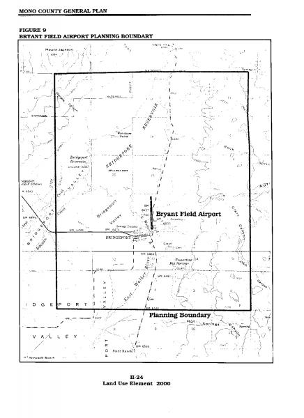
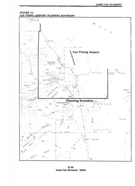
The following briefly summarizes the major issues, opportunities and constraints concerning land use and airport operations in the Lee Vining and Bridgeport airport planning areas.
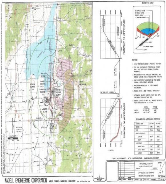
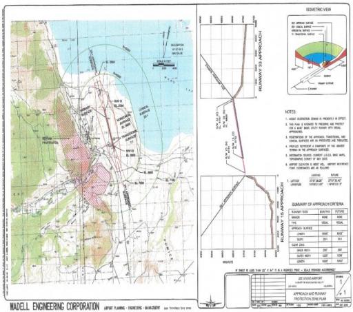
- Airport operations inherently present certain risks to the general welfare of the public and residents within the airport vicinity, particularly the area within the Runway Safety Area. The Runway Safety Area consists of:
-
The primary surface, runway and 20:1 approach surface (see Figure 1 & 2: Runway Protection Zone Plan and Profiles);
-
The area underlying the runway approach and transitional surfaces (see Figures 1 & 2: Runway Protection Zone Plan and Profiles); and
-
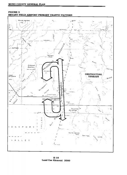
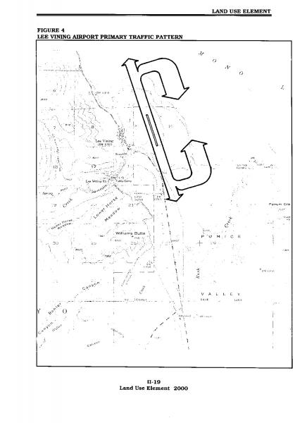
The area within the primary traffic pattern (see Figures3 & 4: Primary Traffic Patterns).
The Bryant Field and Lee Vining Airport Master Plans/2020 summarizes detailed FAA criteria and design standards that apply to Bryant Field and Lee Vining Airports, based on approach category A design group 1 aircraft with visual approaches to both ends of the runway. These criteria address runway and taxiway widths, lengths, and clearance standard dimensions. The criteria specifically address the Runway Safety Zone, the Obstacle Free Zone, and the Runway Protection Zones, in addition to other areas of the airport.
- Since aircraft align with the approach/departure surface when landing or taking off on runways, these areas carry the highest volume of air traffic. Aircraft change power settings to take off or land in this area, so they have a tendency to have more problems within these areas. An Approach and Runway Protection Zone Plan in the Bryant Field and Lee Vining Airport Master Plans/2020 contains plan view information for the runway approach areas. At Bryant Field, these drawings indicate that the terrain east of the airport penetrates the conical and portions of the horizontal surface; it is appropriate that the aircraft traffic pattern is west of the runway (Wadell, p. 25, see Figure 3, Primary Traffic Patterns--Bryant Field Airport). At Lee Vining, these drawings indicate the terrain west of the airport penetrates the conical and portions of the horizontal surface; it is appropriate that the aircraft traffic pattern is east of the runway (Wadell, p. 26, see Figure 4, Primary Traffic Patterns--Lee Vining Airport).
- The Runway Protection Zone, located at ground level beyond the end of the runway, is particularly subject to safety and noise factors (see Figures 1 and 2: Runway Protection Zone Plan and Profiles). The Runway Protection Zone is the most critical zone in which aircraft operations might affect the safety of people and property in the airport vicinity.
Several structures are located within the Runway Protection Zone at the south end of Bryant Field, and a number of residential structures are located in the Bryant Field approach surface. The County has actively pursued acquisition of building and property in the Runway Protection Zone. The runway at Bryant Field cannot be extended to the north due to the proximity of Bridgeport Reservoir. It cannot be extended to the south due to the presence of state highways and local roads.
There are no structures in or near the Runway Protection Zone at Lee Vining Airport. Since the land surrounding the Lee Vining Airport is owned by the City of Los Angeles or is publicly owned land, it is unlikely to be developed. The southern portion of the runway is within the Mono Basin National Forest Scenic Area, another constraint to future development within the area.
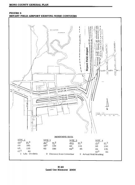
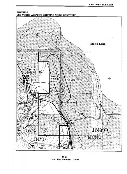
- Noise readings taken at Bryant Field and Lee Vining Airports indicate that noise does not extend much beyond the boundaries of the airport property (see Figures 5 and 6, Bryant Field and Lee Vining Airport Existing Noise Contours). The convergence of aircraft taking off and landing within the approach/departure surfaces intensifies noise levels within those areas. Sensitive noise receptors in the general vicinity of Bryant Field Airport include residential development in the surrounding areas, Bridgeport Elementary School (approximately 0.5 miles to the southwest of the airport), and the Bridgeport Medical Clinic (approximately 0.75 to the southwest of the airport). No residential development or other sensitive noise receptors are planned within the general vicinity of the Lee Vining Airport. The nearest area where additional sensitive noise receptors (e.g., residential development) may occur is the community of Lee Vining, approximately 1 mile to the west of the airport.
At Bryant Field Airport, the 55 dB CNEL contour projects partially into the residential area to the east of the airport. The airport noise impact to this area is infrequent and intermittent, and therefore not significant; this same area experiences greater and more frequent noise impacts from the adjacent highway traffic on SR 182. Airport activity is not projected to increase significantly during the time frame of the current Airport Land Use Compatibility (ALUC) Plan (2020), and therefore noise impacts are not anticipated to become significant. No residential development or other sensitive noise receptors presently exist or are planned adjacent to the Lee Vining Airport.
- Due to the inherent risks associated with airport activities, some land uses need to be restricted in certain airport zones. Neither Bryant Field nor the Lee Vining airport is situated in a manner that significantly conflicts with existing land use. The majority of land surrounding the Bryant Field Airport is publicly owned land and is unlikely to be developed. Existing and proposed development within the community areas of Bridgeport is small-scale residential, commercial, industrial, and public uses that do not conflict with the airport. The Bridgeport Landfill, located to the east of the airport, which in the past may have created a hazard to the airport by attracting birds, has been converted to a transfer station with covered transfer facilities. The majority of land surrounding the Lee Vining Airport is owned by the City of Los Angeles or is publicly owned land and is unlikely to be developed. The southern portion of the runway is within the Mono Basin National Forest Scenic Area, another constraint to future development within the area.
- Bryant Field and Lee Vining Airports are classified as a basic utility general aviation airport, which serves aircraft with approach speeds up to but not including 91 knots (Category A). On occasion the airport receives transient turboprops and business jets (at Bryant Field). The airport should continue to be developed as a basic utility stage I airport handling A-I aircraft (aircraft with approach speeds less than 91 knots and a wingspan of less than 49 feet). Basic Utility Stage 1 airports serve about 75% of the single-engine and small twin-engine airplanes used for personal and small business purposes. Precision approach operations are not usually anticipated.
- Bryant Field and Lee Vining Airport exceed aviation demand throughout the ALUC planning period (2000-2020).
02-03 Policies
Community Development
Land Use
GOAL 13. That June Lake ultimately develop into a moderately sized, self-contained, year-round community.
Objective 13.A.
Promote the expansion of the June Lake Loop's privately owned land base to accommodate planned community growth.
Policy 13.A.1. Promote, where reasonable and feasible, the use of USFS land exchanges to enlarge the privately owned land base to meet community needs.
Action 13.A.1.a. Work with the USFS in identifying suitable lands for exchange or purchase. Lands in the Pine Cliff area should receive priority consideration. This program should respond to the changing needs and desires of the June Lake community.
Action 13.A.1.b. Designate potential land exchange areas on the Land Use Maps and require specific plans prior to developing these areas.
Policy 13.A.2. Promote land trades that transfer developable, non-sensitive lands into private ownership and that exclude hazardous and environmentally sensitive lands from such transfers. Where feasible, the land exchange process should involve lands in the June Lake Planning Area. Encourage reverse land exchanges that transfer hazardous or environmentally sensitive lands in private ownership to public ownership.
Action 13.A.2.a. Work with and support the USFS in the delineation of land exchange boundaries that retain sensitive areas in public ownership and transfer private lands in sensitive areas to public ownership.
Policy 13.A.3. Consistent with the intent Chapter 25 of the Land Use Element, approve Transient Rental Overlay Districts (TRODs) only within June Lake residential neighborhoods exhibiting support for allowing transient rental of single family homes.
Objective 13.B.
Promote well-planned and functional community development that retains June Lake's mountain-community character and tourist-oriented economy.
Policy 13.B.1. Use specific plans to guide the development of large parcels in undeveloped areas.
Action 13.B.1.a. Require the preparation of well-coordinated specific plans for the West Village/Rodeo Grounds prior to further development. Specific plans should also be prepared for undeveloped National Forest lands being exchanged into private ownership. This would include potential exchange lands at Pine Cliff.
Objective 13.C.
Contain growth in and adjacent to existing developed areas, and retain open-space buffers around each area.
Policy 13.C.1. Encourage compatible development in existing and adjacent to neighborhood areas.
Action 13.C.1.a. Use the area-specific land use maps, specific plans, the Plan Check and Design Review processes to guide development.
Action 13.C.1.b. Encourage compatible infill development in the Village and Down Canyon areas.
Policy 13.C.2. Discourage development in areas unsuitable for land improvements.
Action 13.C.2.a. Identify and prioritize sensitive private lands acceptable for exchange or purchase. Designate these lands on the plan's Land Use Maps.
Action 13.C.2.b. If reverse land exchanges or purchase are not possible, allow development under the controls established in the natural habitat protection district.
Objective 13.D.
Balance the rate of development throughout the separate neighborhood areas. Where prudent and feasible, balance the rate of development in new areas and the rate of infill and revitalization in established areas.
Policy 13.D.1. Promote programs that couple new construction in undeveloped areas with improvements in developed areas.
Action 13.D.1.a. Extract developer fees to fund capital improvements during the permit process in accordance with applicable State law. Ensure fees are levied on a uniform basis and that moneys collected for a specific purpose are used for that purpose.
Action 13.D.1.b. Investigate the feasibility of issuing bonds or implementing other revenue-producing measures such as assessment districts or bed taxes to finance desired facilities.
Policy 13.D.2. Promote the phasing of development where appropriate.
Action 13.D.2.a. Require specific plans to specify the phasing of development over a number of years.
Action 13.D.2.b. Work with the USFS to prioritize potential land exchange areas to reflect changing community needs (see the Landownership Adjustment Project report in the Appendix).
Objective 13.E.
Utilize land use designations to stimulate revitalization in depressed areas, to limit and phase out incompatible uses, and to guide June Lake’s future.
Policy 13.E.1. Encourage infilling and/or revitalization in areas designated for development in the Area Plan.
Action 13.E.1.a. Allow higher densities and provide for mixed uses in areas suitable for commercial and retail development.
Action 13.E.1.b. Study the feasibility of revitalization activities in the Village and Down Canyon areas. The options of establishing a Zone of Benefit to fund public improvements should be studied.
Action 13.E.1.c. Apply for federal and state economic development grants when funds become available.
Objective 13.F.
Protect existing and future property owners and minimize the possibility of future land ownership/use conflicts through the building and planning permit processes.
Policy 13.F.1. Utilize the building and planning permit processes to prevent new construction from encroaching into required setbacks and rights of way.
Action 13.F.1.a. Require applicants to identify property boundaries and surrounding geographical features, such as streams and roadway easements, on plans submitted to the County. Property boundaries should be identified either by: 1) lot survey conducted by a person authorized to practice Land Surveying in California by the State Board of Registration for Professional Engineers; or 2) the positive identification of brass corners or other property line markers set by prior survey.
Policy 13.F.2. Continue the comprehensive code compliance program for June Lake.
Action 13.F.2.a. Maintain a Code Compliance position, with citation power, to enforce land use regulations and permit conditions.
Action 13.F.2.b. Current activities, such as the outdoor storage of equipment, building materials, and non-running motor vehicles, or other incompatible uses, shall be phased out of commercial and residential districts. These types of uses should eventually relocate to a designated industrial site within a specific plan area.
Action 13.F.2.c. Investigate the feasibility of establishing a property maintenance ordinance to prohibit and phase out undesirable uses.
Objective 13.G.
Meet the land needs of the commercial/industrial uses.
Policy 13.G.1. Designate industrial site(s) of adequate size to accommodate the existing and projected light industrial needs of June Lake.
Action 13.G.1.a. Implement an illegal use abatement program after an industrial site has been established.
Action 13.G.1.b. Explore the possibility of providing financial assistance to displaced industrial operations. Alternatives such as providing a one-time relocation payment or short-term low-income loans to help offset moving expenses should be explored for displaced users that can show financial need.
Action 13.G.1.c. Examine the potential for locating limited light industrial areas for the storage and repair of heavy equipment (e.g., snow removal) within the Specific Plan area of West Village/Rodeo Grounds. If the studies indicate that an industrial complex would be incompatible and inconsistent with surrounding land uses, or would have significant environmental impacts, pursue a special use permit or land trade with the USFS to enable locating an industrial area in the Pine Cliff area.
Action 13.G.1.d. Allow existing industrial uses to continue on USFS lands in the Pine Cliff area.
Objective 13.H.
Balance the development of recreational facilities with the adequate provision of public amenities, employee and visitor housing, infrastructure, and circulation facilities.
Policy 13.H.1. Large new recreational developments shall consider indirect impacts as well as direct impacts. Besides the obvious impacts on water, sewer or other facilities, new developments must consider impacts created by increased visitation and employment.
Action 13.H.1.a. Net employee-generating operations should meet the employee housing requirements of the Community Development Element.
Action 13.H.1.b. The County, USFS, other government agencies, and project proponents should coordinate efforts to ensure that the indirect impacts of new development projects are addressed prior to approval.
Action 13.H.1.c. Work with the USFS to ensure that activities on National Forest System lands can be supported by the existing community infrastructure and that the benefits of the proposed developments outweigh adverse impacts on the community.
Action 13.H.1.d. Specific plans and accompanying EIRs for large development projects should address the cumulative impacts on recreational resources from increased visitation and use, and on community infrastructure including roads, housing, sewer, water, utilities, fire protection, and schools.
Objective 13.I.
Maintain the June Lake Village as the Loop's commercial core by providing a wide range of commercial and residential uses in a pedestrian-oriented atmosphere.
Policy 13.I.1. Promote the concentration of resident-oriented professional services such as financial management, real estate, law, and healthcare, and community-oriented retail outlets such as grocery stores, pharmacies, and hardware stores, in the Village.
Action 13.I.1.a. Limit the amount of commercial square footage outside the June Lake Village. Market studies, fiscal impact analysis and other documentation, as part of the West Village/Rodeo Grounds Specific Plan process, should demonstrate the need for large-scale commercial development outside the June Lake Village prior to its construction.
Policy 13.I.2. Promote planning studies that concentrate on reducing traffic congestion, enhancing the Village's pedestrian atmosphere and strengthening the commercial district. These planning studies should examine providing an alternative roadway paralleling SR 158 through the Village, off-street parking and pedestrian walkways.
Objective 13.J.
Through the specific plan process, develop the West Village/Rodeo Grounds into a well-coordinated resort area that provides a balance of resident and visitor housing in close proximity to recreational facilities and other activity centers.
Policy 13.J.1. Development in the West Village/Rodeo Grounds should be coordinated through the specific plan process. Specific plan(s) should provide for a balance between local housing and recreational/entertainment facilities, and locate intensive land uses in the least environmentally and visually sensitive areas. Infrastructure and amenities for the entire area, including sewer, water, roads/circulation, recreational facilities such as a coordinated trail system, housing mix, and the siting of commercial nodes shall be coordinated for the entire area prior to approval of any specific plans. Minor projects adjacent to existing developed areas not requiring the preparation of an Environmental Impact Report may be permitted prior to the adoption of the Specific Plan.
Action 13.J.1.a. Provide a wide range of resident and visitor housing in close proximity to recreational facilities through the specific plan efforts. The overall density of the specific plan area should be limited to 10 units per acre. Through the specific plan and EIR processes, higher densities may be allowed if consistent with the general intent of the Area Plan. Resident housing may include single-family residences, townhouses, duplexes, triplexes and apartments. The specific plan area or other suitable lands should also provide employee housing for at least 25% of June Mountain's anticipated peak period workforce based upon the maximum skier capacity allowed by the USFS special use permit. Visitor housing should consist primarily of full-service hotels with meeting/conference facilities, smaller inns and bed-and-breakfast establishments. Limited condominium development may also be included.
Policy 13.J.2. Develop a major commercial/recreational node across from the June Mountain Ski Area. This node may include retail outlets such as convenience stores, gift shops and sporting goods outlets oriented to visitors and residents, and other uses such as restaurants, night-time entertainment facilities such as night clubs and movie theaters. A smaller neighborhood commercial node may also be appropriate elsewhere in the specific plan area, if the need can be demonstrated and a physically suitable and compatible site can be identified in the specific plan.
Action 13.J.2.a. Work with developers through the specific plan process.
Action 13.J.2.b. Explore locating resort and residential development at the base of June Mountain Ski Area through conversations with the community, June Mountain, US Forest Service and other stakeholders, and consider the “Conceptual Plan, June Mountain Ski Base Facilities” (2013).
Objective 13.K.
Retain the Down Canyon's single-family residential character while providing for additional commercial development along SR 158 and pockets of higher-density residential uses.
Policy 13.K.1. Retain the area's single-family residential character while allowing for pockets of higher-density residential developments in areas that have good automobile access and commercial developments, bordering SR 158.
Action 13.K.1.a. Work with the USFS to obtain lands, through the special permit or land trade processes, to construct an equipment-storage yard and additional residential development.
Objective 13.L.
Assure the protection of life and property by maintaining an adequate level of law enforcement services.
Policy 13.L.1. Maintain a level of law enforcement services commensurate with population growth and development.
Action 13.L.1.a. Study response times and the frequency of calls to determine the adequacy of law enforcement services.
Action 13.L.1.b. When determined necessary, require new developers to fund increased law enforcement services.
Housing
Goal 14. Provide residents and visitors with quality housing, a wide array of housing alternatives designed to promote unique experiences, and year-round housing stock; and promote adequate affordable housing.
Objective 14.A.
Ensure future development projects mitigate impacts to the local housing stock.
Policy 14.A.1. Require future development projects with the potential for significant housing impacts to provide a fair share of affordable and workforce housing units; e.g., an amount sufficient to accommodate the housing demand created by the development project, as determined through a housing impact assessment or compliance with the Mono County Housing Mitigation Ordinance.
Action 14.A.1.b. The County shall work with proponents during the specific plan or planning permit processes to ensure compliance.
Action 14.A.1.c. The County shall monitor the employee housing programs to ensure compliance and adjust employee housing policies when necessary.
Policy 14.A.2. Mono County, where feasible, shall work with developers and the June Lake community in constructing and maintaining affordable housing for residents.
Action 14.A.2.a. Density bonuses for affordable housing shall be applied consistent with State law (GC §65915). Where consistent with State law, projects including density bonuses shall not exceed 7.25 or 14.75 UPA in SFR or MFR, moderate-designated areas, respectively. In all other permitted areas, projects shall not exceed 26 UPA for residential units and 60 UPA for commercial lodging units.
Action 14.A.2.b. Units set aside for employee housing or for very-low and low-income tenants, shall be excluded from project density calculations. Projects meeting this criterion, however, shall not exceed the allowable density of 7.25 and 14.75 UPA in SFR and MFR, moderate areas and up to 26 UPA for residential units and 60 UPA for commercial lodging units in all other permitted areas, subject to consistency with State law.
Action 14.A.2.c. Employers providing employee housing should be encouraged to set affordable monthly rents.
Policy 14.A.3. Promote year-round housing types and housing for low- and moderate- income households.
Action 14.A.3.a. If necessary, the County should reinstate the Housing Mitigation Ordinance that would provide housing for low- and moderate- income households.
Action 14.A.3.b. Where feasible, encourage the USFS to amend its permittee housing policies to accommodate rental housing.
Community Facilities
Goal 15. Provide residents and visitors with a level of community facilities that improves the self-sufficiency of June Lake by reducing the demand on community facilities located in outlying areas.
Objective 15.A.
Promote the development of community facilities that enhance the health, welfare and safety of local residents (e.g., elementary school, healthcare facilities, and child care).
Policy 15.A.1. Facilities requiring large land areas, such as school sites, shall be located in designated specific plan areas or on potential National Forest exchange lands.
Action 15.A.1.a. Work with the USFS to identify suitable lands for future community facility needs such as, but not limited to, schools, a museum and equipment storage / healthcare sites.
Policy 15.A.2. The County, in cooperation with the community and the Eastern Sierra School District, should identify and help obtain lands for future school sites.
Action 15.A.2.a. Work with the USFS to reserve and/or obtain lands for elementary, high school and community college sites.
Policy 15.A.3. Where feasible, encourage multiple uses of school facilities. Recreational opportunities and after-hour community meetings and classes should be considered in designing and locating school facilities.
Action 15.A.3.a. Work with the community and Special Districts in addressing the requirements for schools, community meeting facilities and recreational opportunities.
Policy 15.A.4. Promote the development of child-care programs and after-school recreational programs for school-aged children.
Action 15.A.4.a. Assist in the development of such programs by providing child-care providers with information and assistance in obtaining space for such purposes.
Action 15.A.4.b. Investigate the possibility of providing increased recreational opportunities for school-aged children. These programs could include: arts and crafts; skiing, fishing or other outdoor activity lessons; and organized sports such as baseball, soccer, basketball or football (see Recreation section).
Objective 15.B.
Ensure that new development helps fund the expansion of community facilities. Fees or exactions should match the level of demand created by new projects.
Policy 15.B.1. Collect mitigation fees or use other appropriate measures to ensure that new development pays the associated cost of expanding community facilities.
Action 15.B.1.a. Use the planning permit process to collect fees for expanding community facilities. Exactions shall not exceed the cost of developing community facilities to the level of demand created by new projects. Fees shall be levied on a uniform basis and moneys collected for a specific purpose will be used for that purpose (Government Code Section 53077).
Action 15.B.1.b. Use the Environmental Review Process (CEQA) to ensure proper mitigation for impacts to community facilities that could result from new developments.
Objective 15.C.
Support broad-based community development, such as community-serving commercial activities (e.g., pharmacy).
Policy 15.C.1. Locate community-serving commercial land uses in the June Lake Village.
Action 15.C.1.a. Use land use designations to limit the number of community-serving facilities located outside the Village.
Objective 15.D.
Enhance the community by using public or private funding to provide desired community facilities.
Policy 15.D.1. Use public or private funding to develop community facilities.
Action 15.D.1.a. Investigate the feasibility of issuing bonds or implementing other revenue-producing measures such as assessment districts or bed taxes to finance desired facilities.
Community Infrastructure
Goal 16. Plan and develop community infrastructure at a rate that ensures new demands will not overburden existing facilities, and ensure the expansion of existing facilities associated with new development does not place undue financial burdens on existing users and impacts on the environment.
Objective 16.A.
Maintain local service capabilities by ensuring that new construction service demands do not exceed the capacity of existing public facilities.
Policy 16.A.1. Prohibit developments that will create excessive demand on the ability of the local service providers to supply water and sewage treatment, among others, unless adequate mitigation is provided.
Action 16.A.1.a. Developers, as a condition of approval, shall obtain written confirmation from the June Lake Public Utility District or other local public utility operators that adequate water supply and sewage treatment capacity exist.
Action 16.A.1.b. On larger projects, use the specific plan process to ensure that new developments have adequate water supplies and wastewater capacity.
Action 16.A.1.c. In cases where additional capacity is needed, exactions assigned by the June Lake Public Utility District for specific water and sewage projects shall be collected. These exactions will not exceed the benefits derived from the construction (Government Code Section 53077).
Action 16.A.1.d. The County shall work with local water and sewage treatment agencies in securing state and federal grants for service improvements.
Action 16.A.1.e. Work with local public utility and service agencies to ensure that services such as telephone, electricity and cable television, among others, expand at a rate consistent with new service demands and take advantage of new technologies and infrastructure, such as Digital 395.
Policy 16.A.2. Encourage the consolidation of local service agencies to improve efficiency, to allow for flexibility in service financing, and to improve local control and accountability.
Action 16.A.2.a. Support Local Agency Formation Commission (LAFCO) and Special District efforts to consolidate local service districts at June Lake.
Objective 16.B.
Develop a wastewater collection and treatment system that provides for present and future needs of residents and visitors, protects the environment, and conserves potable waters.
Policy 16.B.1. Ensure that the wastewater treatment system and trunk lines have adequate capacity to handle new developments.
Action 16.B.1.a. Work with the June Lake PUD to ensure that adequate wastewater treatment capacity exists, or will be available, prior to approving development.
Action 16.B.1.b. Work with the June Lake PUD to promote the use of water-conserving fixtures in existing and new developments to postpone expanding the existing wastewater treatment plant.
Community Design
Goal 17. Maintain and improve the visual quality of the June Lake Loop's environment by enhancing existing structures, guiding future development and preserving scenic views.
Objective 17.A.
Continue to preserve and maintain June Lake's mountain village and rural character through appropriate land development regulations and practices.
Policy 17.A.1. Establish architectural guidelines that maintain and enhance the scenic qualities of June Lake. A single architectural theme shall not govern development in the Loop; rather the compatibility and scale of structures with the surrounding built and natural environments will be stressed.
Action 17.A.1.a. Continue to implement and refine as needed architectural guidelines for June Lake that apply to new construction and large-scale improvements to existing structures. Guidelines shall not apply to single-family homes in existing subdivisions (see Appendix 1, June Lake Loop Design Review Guidelines).
Action 17.A.1.b. Provide a compatible architectural theme in the West Village/Rodeo Grounds area through the specific plan process.
Policy 17.A.2. Maintain diligent control over signs in order to minimize visual impacts.
Action 17.A.2.a. Use signing policies found in the countywide Design Guidelines, Scenic Overlay District, and sign regulations to control undesirable signs or other advertising along the SR 158 corridor.
Action 17.A.2.b. Implement and enforce the county Sign Ordinance (Chapter 07 in the General Plan Land Use Element) in June Lake.
Action 17.A.2.c. Prohibit the use of individual off-site advertising signs or billboards (MCZDC, Chapter 19.317.060) (See 07.060 Prohibitions in the General Plan Land Use Element) in June Lake, but work with the USFS, Caltrans and the business community to develop community kiosks at strategic locations that promote individual businesses, yet do not harm the scenic qualities of the Loop.
Policy 17.A.3. Develop and implement a street-signing program that is compatible with the mountain/rural character of June Lake.
Action 17.A.3.a. The County shall work with the community in developing a Loop-wide street-signing program.
Action 17.A.3.b. Where appropriate, off-site roadway improvements shall include appropriate street signs.
Objective 17.B.
Emphasize the visual predominance of the natural environment by minimizing the visual impact of the built environment.
Policy 17.B.1. Minimize the obstruction of views into, out of, and across major and minor visual elements of the natural environment.
Action 17.B.1.a. Use the June Lake Design Guidelines to evaluate visual obstruction of project proposals on major and minor features of the natural environment. Signs, building heights, and building shapes, among others, should be reviewed for consistency.
Action 17.B.1.b. Review projects for visual competition with the natural environment. At a minimum, this should include the location, the mass shape, and the materials and colors, of signs and buildings.
Policy 17.B.2. Protect and enhance, where feasible, scenic vistas from SR 158 and other viewing areas.
Action 17.B.2.a. Promote appropriate visual screening of project proposals within significant view areas of SR 158 and major and minor features of the natural environment. This may include the use of natural and built visual barriers, breaks or screens such as landforms, berms and vegetation. Visual screening along SR 158 may not be required in the June Lake Village and in the Down Canyon's roadside neighborhood commercial and commercial lodging areas.
Action 17.B.2.b. During the planning permit or specific plan processes work with applicants to promote developments that are sensitive to the visual quality of the natural setting.
Action 17.B.2.c. Promote the use of color and material studies to aid in evaluating the visual impacts of development from SR 158 and from major and minor features of the natural environment.
Action 17.B.2.d. Work with Caltrans and the USFS to minimize the visual impacts of new roadway projects.
Action 17.B.2.e. Where feasible, limit the number of new intersections with SR 158 by designing individual driveways or collector streets to exit onto an arterial or other roadway prior to joining SR 158.
Action 17.B.2.f. Where feasible, work with Southern California Edison to underground, relocate or visually screen power lines and other facilities in areas of high visual quality. Lines and facilities crossing, running adjacent to or visible from SR 158 and the West Village/Rodeo Grounds should receive priority consideration.
Action 17.B.2.g. Where feasible, require new development to underground all new power lines (see Chapter 11 of the General Plan Land Use Element).
Action 17.B.2.h. Investigate the feasibility of and financing mechanisms for placing existing overhead utility lines underground.
Action 17.B.2.i. Encourage consolidation of propane tanks.
Policy 17.B.3. Minimize the visual impacts of hill-slope developments.
Action 17.B.3.a. Promote structural designs that conform to the natural landform of hill slopes. Designs should complement the natural contours of hill slopes and not promote excessive areas of cut and fill.
Action 17.B.3.b. In cases where cut and fill is necessary, encourage developers to blend in altered areas with surrounding natural areas. Disturbed areas, except in cases where greater land alterations may occur, should be designed to resemble the steepness and vegetative character of surrounding undisturbed areas.
Action 17.B.3.c. Work with the USFS and June Mountain Ski Area to minimize the visual impact of new ski area development.
Objective 17.C.
Promote the maximization of scenic views from commercial establishments.
Policy 17.C.1. Promote locating developments to maximize scenic views, while minimizing the effects on the surrounding environment.
Action 17.C.1.a. Review development plans for viewsheds from projects and from vantage points overlooking the proposed projects during the planning permit process.
Action 17.C.1.b. Where feasible, work with developers to visually screen or otherwise minimize scenic impacts of developments.
Objective 17.D.
Visually link the districts of the June Lake Loop while retaining the continuity and compatibility of an individual district's visual identity.
Policy 17.D.1. Promote the use of design measures that visually enhance the Loop's character, yet provide for diversity within individual districts.
Action 17.D.1.a. Develop streetscape elements that are common in all districts, especially along SR 158. This may include the repetition of elements such as street signs, distinctive lamp posts, or vegetation that utilize similar shapes, materials, colors and styles.
Action 17.D.1.b. Utilize the Loop's generic building characteristics to facilitate continuity and compatibility between buildings located in different districts. These characteristics may include roof form, primary entries, building shapes, exterior building materials, doors and windows, and building trim.
Action 17.D.1.c. Maintain the "intimate" or pedestrian scale of June Lake's built environment in all districts.
Policy 17.D.2. Establish the visual identity of each district.
Action 17.D.2.a. Promote the use of a variety of measures that will aid in distinguishing districts. Simple measures may include district identity signs, while more complex measures, designed to present a district theme, could include a single type of street tree, street names, particular vegetative plantings, street furniture, and lampposts, among others.
Policy 17.D.3. Promote transitional designs in neighboring developments to maintain the identity of individual districts.
Action 17.D.3.a. During the planning permit and specific plan processes, review site elements for transitional qualities between adjoining properties. These transitional qualities may include similar or complementary setbacks, scale, landscaping, and signing, among others.
Action 17.D.3.b. During the planning permit and specific plan processes, review building elements for transitional qualities in relation to other buildings of the district, or immediate neighborhood. Transitional qualities should include the repetition, or inclusion, of generic building characteristics found in the area such as roof form, entries, building shapes, exterior building materials, doors and windows, and building trim, among others.
Open Space and Conservation
General
GOAL 18. Conserve and enhance the quality of the June Lake Loop's natural, scenic and cultural resources.
Objective 18.A.
Protect the Loop's natural environment by guiding development in environmentally sensitive areas and by mitigating the impacts of development to the greatest extent practical.
Policy 18.A.1. Mitigate impacts or limit development to an appropriate level in environmentally and visually sensitive areas. Environmentally sensitive areas include: riparian areas, potential high groundwater table zones, wetlands, and steep hill slopes.
Action 18.A.1.a. Ensure projects on lands designated for natural habitat protection or located in environmentally sensitive zones adequately consider and protect areas of high natural resource value.
Action 18.A.1.b. Discourage, where feasible, the filling or dredging of wetlands, related springs or high-water table areas, and waterways, and direct applicants to applicable regulatory agencies such as the Lahontan Regional Water Quality Control Board.
Action 18.A.1.c. Ensure projects protect the ecosystem functions of vegetation within natural habitat protection districts and in environmentally sensitive areas.
Action 18.A.1.d. Reduce, to the extent possible, the impacts of cutting, filling, grading or excavation on the natural water regimen, vegetation stability, land form or stream morphology.
Action 18.A.1.e. Work with local, state and federal agencies to identify environmentally sensitive areas and to develop measures for their protection. Should conflicts occur over the designation of sensitive areas, expert studies, provided by the project proponent, will be required to prove that the area in question does not qualify as an environmentally sensitive area.
Action 18.A.1.f. Work with state and federal lead agencies in resolving conflicts over the delineation of environmentally sensitive areas.
Policy 18.A.2. Promote USFS land exchanges and/or purchases by land conservation groups of sensitive areas. Where such exchange or purchase is infeasible, guide development to protect environmentally sensitive areas.
Action 18.A.2.a. Use USFS land exchanges to protect environmentally sensitive private lands. Two areas, the Silver Lake Meadow and the hill-slope lands overlooking the June Lake Village, are recommended for land exchange. If trades are not possible, limited compatible development should be allowed. Larger parcels in environmentally sensitive areas would be subject to specific development controls designed to minimize impacts on sensitive areas.
Action 18.A.2.b. Work with land conservation groups that specialize in acquiring conservation easements, purchasing environmentally sensitive private lands and holding them as natural preserves, or eventually turning them over into public ownership.
Action 18.A.2.c. Work with the USFS to facilitate land exchanges within the June Lake Loop involving federal lands not possessing high habitat or visual resource values. Federal lands traded into private ownership should be located near established, developing or Area Plan-designated community areas. Reverse land exchanges, or trading highly sensitive private lands for less-sensitive National Forest lands, should also receive priority consideration. Due to the limited private land available within the Loop, lands exchanged into federal ownership should be traded for developable lands in the June Lake Loop, if feasible.
Stream-side Zones
Policy 18.A.3. Protect riparian vegetation, water quality and fish habitat by minimizing encroachments into stream-side zones.
Action 18.A.3.a. Require applicants of projects located near or adjacent to Rush, Reversed (starting at Gull Lake), Fern, Yost, Alger and Snow creeks to show indicated creeks and/or adjacent stream-side parcels on planning permit application maps filed for County review.
Action 18.A.3.b. Applicants on lots near or adjacent to Rush, Reversed (starting at Gull Lake), Fern, Yost, Alger and Snow creeks will be encouraged to design facilities that do not encroach upon waterways. After demonstrating that all reasonable measures have been taken to prevent development in stream-side zones, applicants will be able to pursue setback deviations. In no case shall foundations be located closer than 20 feet from the bank of these creeks.
Action 18.A.3.c. New subdivisions and parcel maps proposed in stream-side zones shall provide stream setbacks of 30 feet from the bank.
Potential High Groundwater Table Areas
Policy 18.A.4. Discretionary projects located in potential wetland areas should be reviewed by applicable regulatory agencies such as the US Army Corp of Engineers (Corp).
Action 18.A.4.a. Projects with the potential to disturb wetlands should be reviewed by applicable agencies such as the Corp prior to submitting development applications to the County.
Policy 18.A.5. Limit the intensity of development in identified wetland areas.
Action 18.A.5.a. Structures and attendant facilities shall, to the extent feasible, be located in non-wetland areas. Projects subject to discretionary permits will be encouraged to use alternative site designs such as clustering or zero lot line developments to avoid constructing on wetland areas. Variances may be obtained for height, setback, or other restrictions to promote construction on non-wetland areas.
Action 18.A.5.b. Limit the intensity of development in identified wetland areas and encourage designs that cause minimal physical disturbances to natural site conditions. Designs should minimize impacts on existing vegetation, soils, and drainage patterns. Disturbed areas should be revegetated prior to the issuance of a Certificate of Occupancy.
Policy 18.A.6. Protect the water quality of groundwater basins by preventing the introduction of surface contaminants and minimizing changes to existing surface coverings in recharge zones.
Action 18.A.6.a. Projects subject to discretionary permits should be designed to minimize the alteration of lands overlying shallow groundwater tables and in recharge zones.
Action 18.A.6.b. Ensure that surface waters released from projects near areas of shallow groundwater and recharge zones meet the pollutant discharge standards of the Lahontan Regional Water Quality Control Board.
Natural Habitat Protection District
Objective 18.B.
Protect lands identified in the natural habitat protection district (LUD map reference) and potential high groundwater table areas (MEA reference).
Policy 18.B.1. Preserve natural habitat areas by limiting development and curtailing harmful uses on identified wetland areas. Assign top priority to these lands for land exchanges.
Action 18.B.1.a. Prohibit the grazing of horses or other livestock on wetland areas such as the meadow and marshes in the Natural Habitat Protection District. A section of the Silver Lake Meadow is the only area falling under this designation.
Action 18.B.2.b. Limit development in natural habitat zones to retain sensitive environments while allowing for compatible development. The extent of development in the natural habitat protection district will depend upon the amount of land within the district not covered by wetlands (non-conflict areas), and in compliance with the land use designation. Three scenarios can occur:
If the entire parcel is covered by wetlands, then a maximum of 2% of the parcel may be altered.
If between 1% and 3% of the parcel is covered by non-wetland areas, then the total non-wetland area and wetland area, not to exceed 3% in combination, may be altered.
If more than 3% of the parcel contains non-wetland habitat, development will be limited to a maximum of 3% of the total parcel area or 15% of non-wetland areas, whichever is greater.
Land alteration limits shall apply to the placement and design of structures, roads, utilities, parking, buildings, walkways, and attendant facilities. In wetland areas, these facilities must be designed and constructed to cause minimum physical disturbance to natural site conditions and be approved by the applicable agency.
Action 18.B.2.c. Where feasible, locate development on lands devoid of environmentally sensitive habitats.
Policy 18.B.2. Identify and map wetland areas according to federally approved criteria and develop appropriate mitigation measures.
Action 18.B.2.a. Encourage the US Army Corps of Engineers and the Lahontan Regional Water Quality Control Board (LRWQCB) to identify and map wetland areas contained in the natural habitat protection district.
Action 18.B.2.b. Pursue grants to fund a wetlands identification, mapping and mitigation study for the natural habitat protection area. Any such study should be conducted in accordance with the technical criteria, field indicators, and identification methods cooperatively established by the Corp, EPA, LRWQCB, and any other relevant agencies.
Water Resources
Objective 18.C.
Promote the development of local water resources to meet future domestic needs in a manner that maintains and protects the natural environment.
Policy 18.C.1. New water resource projects in the June Lake Loop should not impact natural resources and recreation.
Action 18.C.1.a. Coordinate efforts with the USFS and June Lake Public Utility District (JLPUD) to develop water supplies in an environmentally sound manner. Oppose water developments that will compromise the integrity of the Loop's recreational and environmental resources.
Policy 18.C.2. Promote the development of a diversified water system to withstand periods of drought without causing undue impacts on the environment.
Action 18.C.2.a. Encourage the JLPUD to investigate using groundwater for domestic needs.
Action 18.C.2.b. Work with the JLPUD to ensure that adequate water supplies exist to meet the water needs of the community at planned buildout during drought years. Require new developments in specific plan areas to develop additional water sources if needed to meet the development's water demand at buildout.
Policy 18.C.3. Use comprehensive water management plans to guide water use, the construction of new water supply facilities, and the protection of natural resources.
Action 18.C.3.a. Promote the development of a comprehensive water management plan by local entities that plan for the present and expected water needs in the Loop. This plan should consider the effects of upstream water diversions on Mono Lake, the visual effects of fluctuating water levels in lakes and streams, and the potential effects of future water diversions on spawning fish or other wildlife.
Policy 18.C.4. Promote water conservation to avoid or delay construction of new water facilities and to preserve the natural environment (see the General Plan Conservation/Open Space Element).
Action 18.C.4.a. Work with local water agencies to develop and implement policies that promote water conservation. Policies could include measures to encourage planting of native plant species, measures to reduce the water requirements of landscaping, and changes in the Building Code to require the use of water-conserving fixtures.
Action 18.C.4.b. Work with local water districts to provide residents with literature on water conservation and, if feasible, kits containing water-conserving modification devices.
Policy 18.C.5. Recognize in-stream flows as a beneficial use of water.
Action 18.C.5.a. Work with water and wildlife management agencies to ensure that stream diversions will not harm existing wildlife.
Action 18.C.5.b. Promote studies that establish minimum in-stream flows and lake levels. These levels must protect existing aquatic communities and associated vegetation. Coordinate efforts with local water districts and land and wildlife management agencies.
Action 18.C.5.c. Use the California Environmental Quality Act (CEQA) review process to identify mitigation measures and alternatives to water-diversion projects that may have significant environmental impacts.
Action 18.C.5.d. Discourage construction activities (e.g., bridges and stream realignments) that alter stream channels near fish-spawning habitat and during periods when fish are spawning or when eggs are incubating in the stream gravel.
Action 18.C.5.e. Discourage developments that alter the configuration or flow of minor creeks or drainage channels tributary to major creeks. Also discourage activities that increase water turbidity, sedimentation and silting of water bodies and streams.
Action 18.C.5.f. Coordinate efforts with the California Department of Fish and Wildlife on projects requiring stream-alteration permits.
Action 18.C.5.g. Prohibit direct and indirect discharges of soil, debris, or other material into waterways. Indirect discharges shall be controlled by minimizing the possibility of substances washing into a water body.
Action 18.C.5.h. Construction operations requiring repeated stream crossings shall install temporary bridges.
Objective 18.D.
Protect the water quality and clarity of the June Lake Loop by reducing or eliminating sources of contamination to lakes, streams and sub-surface water supplies.
Policy 18.D.1. Minimize impacts on surface and groundwater resources by limiting erosion and uncontrolled storm water discharges.
Action 18.D.1.a. Encourage developers to incorporate erosion control measures that create a zero off-site net increase in runoff into project designs. These measures could include revegetation programs, rip-rapping, side drains, blankets or erosion nets, among others.
Action 18.D.1.b. Require developments, including single-family homes on soils highly susceptible to erosion or on steep slopes, to submit erosion-control plans as part of the planning permit process. Consider adopting erosion control and revegetation guidelines for single-family homes in all areas.
Action 18.D.1.c. Work with other agencies such as the Lahontan Regional Water Quality Control Board and June Lake Public Utility District to ensure that erosion and drainage control measures are adequate to protect water resources.
Action 18.D.1.d. Mitigate siltation on Rush Creek and at the inlet to Silver Lake.
Action 18.D.1.e. The County shall work with the USFS to encourage the June Mountain Ski Area to continue to develop and implement comprehensive erosion-control measures. These measures should be equivalent to or exceed the county Granding Ordinance.
Action 18.D.1.f. Utilize Best Management Practices (BMPs) including, but not limited to, the Low Impact Development (LID) techniques in the Appendix of the General Plan to minimize the effects of runoff.
Policy 18.D.2. Minimize the possibility of erosion and off-site discharge of storm waters by retaining the existing vegetative cover.
Action 18.D.2.a. Promote the preservation of trees and other vegetation by limiting removal to areas necessary for primary access ways, building footprints and parking areas. During the planning permit process work with the applicant to minimize the removal of vegetation.
Action 18.D.2.b. Timberland owners converting timberland to non-timber uses shall comply with State requirements for a Timberland Conversion Permit or an exemption (see 14 CCR §1104).
Policy 18.D.3. Limit or control development on steep slopes to minimize impacts on watersheds.
Action 18.D.3.a. Minimize development on hillsides by promoting development on flatter sections of parcels and larger minimum-lot sizes.
Action 18.D.3.b. Discourage uniform geometrically terraced building sites contrary to the natural land forms that substantially detract from the scenic and visual quality of the natural setting, and that substantially alter natural drainage patterns, vegetative cover, and significant wildlife habitat.
Action 18.D.3.c. Require geotechnical reports, provided by the project proponent, to demonstrate that the hillside is geologically stable and adequate for alteration, prior to substantially altering hillsides with slopes greater than 20%.
Action 18.D.3.d. The subdivision of any lands shall adequately consider slope conditions and comply with the standards set forth herein, or shall be prohibited.
Policy 18.D.4. Protect surface and groundwater by reducing the amounts of contaminants introduced by storm-water runoff.
Action 18.D.4.a. The County should work with Caltrans, Lahontan Regional Water Quality Control Board, USFS, June Lake Public Utility District and the community to initiate and/or facilitate programs designed to reduce the amounts of contaminants in storm water. Street sweeping and other litter cleanup programs should be included in this approach.
Policy 18.D.5. Protect the water quality of June and Gull lakes and other downstream water bodies by improving the June Lake Village's drainage system and eliminating other sources of pollution.
Action 18.D.5.a. The County should coordinate efforts with Caltrans, the JLPUD, the USFS and the Lahontan Regional Water Quality Control Board to develop and implement a master drainage control plan for the June Lake Village. This effort should examine alternatives to control runoff into Gull and June lakes, including on-site ponding/retention and undergrounding the drainage ditch between June and Gull lakes. Project funding mechanisms such as bonds and zone-of-benefit charges, among others, also should be considered.
Action 18.D.5.b. Encourage the Lahontan Regional Water Quality Control Board to conduct an eutrophication study on Gull Lake and, where feasible, adopt the study's recommendations.
Air Quality
Objective 18.E.
Maintain a high level of air quality that protects human health and wildlife, and prevents the degradation of scenic views.
Policy 18.E.1. Reduce automobile use by promoting the development of pedestrian-oriented villages that include convenient, centrally located off-street parking; pedestrian walkways; transit service; direct ski access; and bicycle, hiking and cross county trails.
Action 18.E.1.a. Promote the development of trails for non-motorized modes of transit (e.g., pedestrians, cross country skiers and bicyclists). These trails should link major lodging and parking facilities with recreational and commercial centers and should be maintained year round. Bond issues, grants or development exactions, among others, could be used to fund construction.
Action 18.E.1.b. Work with the June Mountain Ski Area to develop ski-back trails from the ski area to concentrated use areas.
Action 18.E.1.c. Investigate the feasibility of developing an overhead lift into the Village from the Mountain. If developed, ensure the lift will: 1) operate during the summer months and complement the summer recreation attractions of the Village area; 2) minimize the visual impacts to the Village, June Lake and Gull Lake; and 3) be architecturally compatible with other village developments. If a lift proves infeasible, work with the Ski Area to develop a transit system from the Village and West Village/Rodeo Grounds to the ski area.
Action 18.E.1.d. Promote the development of crosswalks in the Village and the June Lake Loop that enhance safety, complement the non-motorized vehicle trails, and promote the Village and Loop's pedestrian atmosphere.
Action 18.E.1.e. If feasible, use the specific plan process in the Village to promote the development of facilities conducive to the pedestrian-oriented concept.
Policy 18.E.2. Reduce emissions from solid fuel-burning appliances (see the General Plan Conservation/Open Space Element).
Action 18.E.2.a. Work with the Great Basin Air Pollution Control District to sponsor public information programs regarding solid fuel-burning appliances.
Action 18.E.2.b. Work with property owners and developers to utilize decorative propane, pellet stoves, or other clean-burning heat sources instead of solid fuel-burning appliances (e.g., wood stoves).
Policy 18.E.3. Promote energy-efficient / “green” construction and retrofits, and residential and nonresidential distributed renewable energy generation.
Action 18.E.3.a. At the earliest planning/design stage possible, refer applicants to the General Plan Conservation/Open Space Element for policies on energy use in new and existing buildings, and renewable energy generation.
Historic and Cultural Resources
See the General Plan Conservation/Open Space Element for policies to identify, preserve, restore, and interpret cultural resources.
Objective 18.F.
Identify and preserve significant cultural and historical resources or artifacts and, where feasible, provide displays or interpretive tours (19).
Policy 18.F.1. Promote local protection, interpretation, and preservation of cultural resources within the June Lake Loop.
Action 18.F.1.a. Encourage the County to support the June Lake Loop Historical Society and its effort to establish a museum.
Recreation
GOAL 19. Provide community-oriented recreational facilities and programs that meet the needs of June Lake's population.
Objective 19.A.
Complement the wide range of outdoor recreational activities by providing traditional recreational facilities for residents.
Policy 19.A.1. Provide for the recreational needs of permanent and seasonal residents.
Action 19.A.1.a. The County should promote the development of neighborhood and community parks.
Action 19.A.1.b. Acquire land for parks and other recreational sites through the USFS land exchange and special use procedures.
Action 19.A.1.c. The County shall pursue the development of recreational facilities and/or parks near the West Village/Rodeo Grounds Specific Plan, Down Canyon areas, Pine Cliff area, and/or other areas identified by the community.
Action 19.A.1.d. Consider developing a Parkland Dedication Ordinance pursuant to Government Code Section 66477(b).
Action 19.A.1.e. Through the specific plan process, the County should provide incentives for developers to dedicate areas for parks and plan for their development.
Action 19.A.1.f. The County should pursue federal, state, nonprofit, and other funds and partnerships for the acquisition, construction and maintenance of parks or other recreational facilities. Action 1.8: Parks should be designed and located to meet the needs of all residents including the young, elderly and those with.
Action 19.A.1.g. Continue to support the June Lake Trails Committee and Citizens Advisory Committee (CAC) in community-based trails planning and development, including further development, refinement and implementation of the 2003 June Lake Trail Plan.
Policy 19.A.2. Continue to work with developers to provide publicly accessible indoor recreational facilities for activities such as racquet sports, basketball, volleyball, aerobics, swimming, and ice skating, and outdoor activities such as photography, fly fishing, natural sciences, astronomy, and others.
Action 19.A.2.a. Work with developers during the specific plan process to promote the construction of recreational facilities, and/or contribute to the ongoing maintenance and operations of existing facilities.
Action 19.A.2.b. When available, the County should pursue grants to help construct, maintain, and/or improve community indoor recreational facilities.
Objective 19.B. Ensure that community recreation facilities and programs continue providing the services for which they were designed.
Policy 19.B.1. Improve and maintain community recreation facilities and recreation programs on a regular basis.
Action 19.B.1.a. Maintain existing facilities as a high priority, and program ongoing maintenance and operating costs into the development of new facilities.
Action 19.B.1.b. The County shall work with the community, other agencies and developers to maintain and improve park sites.
Action 19.B.1.c. The County shall work with the community or other groups to operate and maintain parks. This program should include public education and neighborhood-watch programs to minimize vandalism and litter. In addition, cooperative efforts should be used to establish pilot recreational programs.
Policy 19.B.2. The County shall periodically review the recreational needs of the community and amend the Area Plan accordingly.
Action 19.B.2.a. The June Lake Citizens Advisory Committee or other community body shall work with the County to study and adjust, if necessary, recreational planning policies to reflect the needs of the community.
Objective 19.C. Locate and design community parks to minimize their effects on surrounding land uses.
Policy 19.C.1. Minimize incompatibilities between recreational uses and surrounding neighboring uses.
Action 19.C.1.a. Provide adequate buffer zones around community parks to mitigate impacts such as noise on surrounding uses.
Action 19.C.1.b. Minimize the use of outdoor lights and ensure compliance with the Dark Sky Regulations.
Action 19.C.1.c. Design parks to have adequate view corridors to provide an unobstructed view of the park site and facilitate public safety and compliance with park regulations.
Policy 19.C.2. Locate and design parks to serve neighborhoods and the entire community.
Action 19.C.2.a. Parks should be centrally located to strategically serve areas within a half-mile radius for neighborhood-scaled parks and two-miles for community-scaled parks.
Action 19.C.2.b. Access should be off SR 158 or other major roadways, ample parking should be available, and the site should be accessible by foot, bike, and automobile.
Action 19.C.2.c. Scenic views, existing vegetation, and waterways should be utilized to enhance the park while minimizing environmental impacts.
Tourism
GOAL 20. Expand and strengthen June Lake's tourist-oriented economy by stimulating the development of year-round recreational facilities and attracting and retaining a diversity of businesses, while protecting June Lake's scenic and natural resource values, and unique character.
Objective 20.A.
Expand and diversify June Lake's tourist base to provide for the year-round needs of multiple user groups, while maintaining the Loop's character and protecting its scenic resources.
Policy 20.A.1. The June Lake community should work with the USFS, June Mountain, Mono County Tourism Commission, June Lake Historical Society, June Lake Chamber of Commerce, and others in a joint effort to operate a Visitor Center in the Village or other appropriate location, and promote the June Lake Loop.
Action 20.A.1.a. Further develop and promote the existing Scenic Byway kiosk as a focal point through ongoing Byway Planning.
Action 20.A.1.b. The existing Scenic Byway kiosk should be better utilized, and local volunteers should continue to assist in staffing it and potentially providing programs.
Action 20.A.1.c. Continue to explore opportunities for a permanent Visitor Center, potentially combined with a historic museum. The center should serve as a Mecca for tourist activity and as a promotional center for the June Lake Loop. The USFS could provide interpretive tours and campfire activities, while June Lake merchants could use the center to distribute literature on the various lodging, dining, and recreational opportunities.
Action 20.A.1.d. The community should work with the USFS to promote the June Lake Loop at nearby visitor centers, such as the Mono Basin Scenic Visitor Center in Lee Vining and the Mammoth Lakes Welcome Center.
Policy 20.A.2. Encourage public recreational use of lakes and creeks that is compatible with the environmental sensitivity of those areas. Consider adjusting public use if increased access causes undue environmental impacts.
Action 20.A.2.a. The County should work with the USFS to continue to improve the shoreline and stream-bank access along roadside lakes and streams along the June Lake Loop. Access to water bodies should emphasize foot or non-motorized vehicle trails over direct automobile access. Parking areas should be provided near water bodies, but trails should provide shoreline access. Trails should also link with day-parking facilities, campgrounds and other population centers to reduce the need for automobile use.
Action 20.A.2.b. Encourage and promote backcountry recreation experiences accessible from the June Lake Loop, including fishing, backpacking, horseback riding, and access to Yosemite National Park.
Action 20.A.2.c. Encourage the CDFW to improve the overall quality and potential of the Loop’s recreational fishery.
Action 20.A.2.d. Protect and enhance fish-spawning habitat within June Lake Loop waters.
Action 20.A.2.e. Cooperate with government and private agencies to inventory the Loop's potential for stream and lake rehabilitation projects. Potential areas could include Parker, Walker and Lower Rush creeks, and siltation of Silver Lake. Once identified, the County and June Lake Public Utility District in conjunction with local, state or national fishing organizations and/or other community groups should apply for grant moneys to carry out the projects.
Action 20.A.2.f. Maintain or increase fish stocking efforts in the June Lake Loop.
Policy 20.A.3. Provide a balance of recreational opportunities to ensure full utilization of the Loop's recreational resources, expanded user group participation, and a complementary mix of recreational activities.
Action 20.A.3.a. Promote diversified recreational experiences by encouraging activities beyond fishing and hiking, such as backpacking, camping, swimming, picnicking, bicycling, interpretive nature study, outdoor arts, special events and festivals. The County, June Lake community, and the USFS should cooperate in developing these activities.
Action 20.A.3.b. Work with the USFS to help identify suitable locations for future drive-in and walk-in campgrounds.
Action 20.A.3.c. Provide for increased water sports activities on Grant Lake (e.g., water-skiing) by amending the boating speed limit that prohibits water-skiing before 10 a.m.
Action 20.A.3.d. Outdoor recreation/education programs should utilize the June Lake Loop's natural and scenic resources by focusing on, to the extent practical, the Loop's unique attributes such as its lakes and streams, hiking trails, scenic beauty, and skiing opportunities, among others. New recreational activities should provide experiences not found in metropolitan areas.
Policy 20.A.4. Provide full winter-time utilization of the June Lake Loop by providing adequate downhill skiing capacity, expanded cross country ski touring opportunities, ice skating and ice games, snowplay areas, and snowmobile staging areas.
Action 20.A.4.a. Support continued operation of the June Mountain Ski Area and future improvements or expansions, including year-round programming and use such as hiking.
Action 20.A.4.b. Promote the development of snowmobiling and cross country ski trails in the June Lake Planning Area. Work with the USFS, Caltrans and the community to develop cross country skiing parking and staging facilities along SR 158 and US 395.
Action 20.A.4.c. Work with the USFS and other entities to identify suitable snowplay areas.
Action 20.A.4.d. Where feasible, design common open-space areas in new developments and neighborhood parks to accommodate snowplay and/or ice skating during winter months.
Policy 20.A.5. Reduce recreational user conflicts by dispersing competing recreational activities and, where prudent and feasible, expanding existing facilities or constructing new ones.
Action 20.A.5.a. Provide for snowmobiling in areas outside the June Lake Loop (for example, Bald Mountain Lookout area), with staging in the Loop, and in areas not used for cross country skiing (e.g., the Obsidian Dome/Glass Creek area has been designated a cross country ski area).
Action 20.A.5.b. Limit equestrian trail use to the Rush Creek, Silver Lake and Grant Lake areas due to the incompatibility of equestrian use with hiking and bicycle trails and the limited widths of available trails.
Action 20.A.5.c. Provide for off-highway vehicle use in appropriate areas outside the June Lake Loop.
Policy 20.A.6. Coordinate recreational planning efforts with the USFS, the LADWP, and private landowners in the June Lake Planning Area to most efficiently utilize resources.
Action 20.A.6.a. Work with the Inyo National Forest to reflect June Lake Area Plan policies in the Forest Plan update.
Action 20.A.6.b. Support an expansion of the USFS' "concentrated recreation area" (or similar) designation in the Lower Rush Creek watershed between Grant and Mono lakes.
Action 20.A.6.c. Work with developers, through the specific plan process, to address the recreational needs of local residents and visitors.
Policy 20.A.7. Avoid conflicts between recreational activities and other competing uses.
Action 20.A.7.a. Work with the USFS, the Los Angeles Department of Water and Power, and other private landowners through the USFS' Coordinated Resources Planning Process to help resolve conflicts between grazing and recreational activities.
Action 20.A.7.b. Support State Water Resources Control Board management and restoration plans, and orders requiring flows and lake levels, related to the Mono Basin.[1]
Objective 20.B.
Diversify and stabilize the local economy by attracting and retaining tourist- and community-oriented businesses, particularly those that provide new jobs for local residents.
Policy 20.B.1. Promote the development of an active program that attracts businesses or helps identify types of businesses that could be successful.
Action 20.B.1.a. Develop an economic development plan.
Action 20.B.1.b. As part of an economic development plan, develop a program that helps attract needed community-oriented businesses. Cooperatives and other ventures could be examined as potential solutions.
Action 20.B.1.c. Coordinate activities with government agencies and community groups to attract commercial/film companies into the June Lake Loop.
Policy 20.B.2. Develop programs that promote local business interests.
Action 20.B.2.a. Encourage employers to hire local residents.
Action 20.B.2.b. Explore mechanisms to prioritize the leasing or purchase of new or existing commercial properties by June Lake residents or present business owners in the Loop first.
Objective 20.C.
Enhance the tourist/recreational orientation of June Lake by developing entertainment/recreational facilities to complement existing daytime recreational uses and to entice visitors to stay longer on the Loop.
Policy 20.C.1. Promote the development of nighttime recreational opportunities such as restaurants and bars, dancing, movie or fine arts theaters in commercial areas located in the West Village/Rodeo Grounds and in June Lake Village.
Action 20.C.1.a. The County, through the Specific Plan and Planning Permit processes, should work with developers to locate nighttime recreational opportunities near visitor accommodations to discourage the use of automobiles and to reduce impacts on local residents.
Policy 20.C.2. Encourage larger-scale tourist/commercial development to provide for convention and meeting facilities.
Action 20.C.2.a. If feasible, promote the development of such facilities in commercial development(s) of sufficient size in the Village area and as a component of the Specific Plan for West Village/Rodeo Grounds.
Policy 20.C.3. Recreational facilities that can serve numerous user groups or provide alternatives to automobile transportation should be provided, where feasible.
Action 20.C.3.a. Support and continue developing a comprehensive trail system plan.
Action 20.C.3.b. Pursue a Loop-wide trail system for pedestrians or cyclists in the summer and cross country skiers in the winter to connect the various population centers and, where feasible, improve shoreline access to lakes and streams. Refer to the June Lake Trail Plan for trail standards and guidelines.
Action 20.C.3.c. Collaborate with applicable agencies to design the trail system. Representatives could include the USFS, Caltrans, Mono County, Southern California Edison, and the community.
Action 20.C.3.d. Pursue various funding options and partnerships to construct and maintain trail projects.
Action 20.C.3.e. Ensure trail projects include a maintenance program and funding source.
Objective 20.D.
Increase visitation to June Lake.
Policy 20.D.1. Develop events, educational programs, and festivals for tourists and local residents that promote the uniqueness of the area and enhance the economy.
Action 20.D.1.a. Encourage the County, local organizations and other agencies to work together to develop events and festivals.
Policy 20.D.2. Develop programs for tourists that focus on the community of June Lake and the many recreational and scenic attributes of the June Lake Loop.
Action 20.D.2.a. Promote the designation of SR 158 as a state Scenic Highway. Follow through on the Caltrans Scenic Highway guidelines, which call for the creation and implementation of design guidelines for visually significant features along SR 158.
Action 20.D.2.b. Work with Caltrans to develop roadside turnout/scenic lookout points along SR 158, and rehabilitate existing locations such as Oh! Ridge.
Action 20.D.2.c. Provide self-guided interpretive tours of the June Lake Loop along SR 158. These tours would function as extensions of the existing scenic lookouts by providing information on local history, geology, archaeology, wildlife and their habitats, and landmarks.
Action 20.D.2.d. Promote the development of programs or activities that encourage visitors to stop in the June Lake Loop.
Policy 20.D.3. Enhance and promote the character of June Lake and its commercial establishments.
Action 20.D.3.a. Encourage the local Chamber of Commerce or other groups to develop and distribute information promoting June Lake using the latest technology and social media.
Action 20.D.3.b. Encourage employers, the Chamber of Commerce or other groups, to develop and implement a public relations and service training program for employees.
Action 20.D.3.c. Encourage business and community cooperation in the development of attractive and visually compatible commercial districts.
Objective 20.F.
Promote June Lake Loop's visual resources.
Policy 20.F.1. Visual resources should be considered when developing recreational uses and design standards.
Action 20.F.1.a. Work with applicable agencies to manage water levels consistent with SWRCB orders and plans.
Policy 20.F.2. Avoid timber harvesting and mining on USFS land where scenic and recreational values would be impaired.
Action 20.F.2.a. Ensure the Inyo Forest Plan update continues to limit timber harvesting and mining to areas outside the June Lake Loop and designated ski areas.
Policy 20.F.3. Promote the recreational and scenic values of the June Lake Loop by encouraging photography, painting, creative landscaping, and sculpture.
Action 20.F.3.a. Encourage the Mono County Arts Council to plan activities and conduct classes in June Lake.
Action 20.F.3.b. The County should encourage proponents of art galleries and studios to locate in the June Lake Loop.
Action 20.F.3.c. Work with Cerro Coso Community College or other entities to offer classes on art or photography in the June Lake Loop.
Other Elements
Safety
The June Lake Area Plan Safety Element was relevant to the entire county and has been expanded to serve as the county General Plan Safety Element. For policies and standards relating to safety issues, please see the General Plan Safety Element and County Hazard Mitigation Plan.
Circulation
The June Lake Area Plan Circulation Element has been integrated into the Mono County Local Transportation Commission’s Regional Transportation Plan (RTP) to ensure mobility policy consistency throughout the county and eligibility for funding by transportation dollars. The RTP also forms part of the Mono County General Plan Circulation Element, and either document may be referenced for June Lake policies.
Solid Waste
Solid Waste policies in the June Lake Area Plan were relevant to the entire county and have been integrated into the county Integrated Waste Management Plan, with relevant supporting policies in the Land Use and Conservation/Open Space elements of the General Plan.
Cultural Resources
The majority of cultural resource policies were relevant to the entire county and have been integrated into the cultural resources section of the county General Plan Conservation/Open Space Element.
[1] http://www.monobasinresearch.org/data/mbrtdframes.htm
[2]A Special Area Management Plan is a set of policies developed cooperatively with the US Army Corps of Engineers to address local wetland development issues.
This section presents policies that apply to private lands in the unincorporated area of the county. It first presents policies that apply to all private land in the unincorporated area. It then presents policies for each of the community areas in the county; i.e., Antelope Valley, Swauger Creek/Devil's Gate, Bridgeport Valley, Bodie Hills area, Mono Basin (Mono City and Lee Vining), June Lake, the Upper Owens area, the Mammoth Vicinity, Long Valley, Wheeler Crest, Tri-Valley, the Benton Hot Springs area and Oasis. Some of the Land Use Policies in this section summarize policies contained in other elements of the county General Plan. Implementation measures for those policies are found in the referenced General Plan Element.
This section also contains the land use policies from the Airport Land Use Plans for the Mammoth Yosemite Airport, the Lee Vining Airport, and the Bridgeport Airport (Bryant Field).
NOTE:
Land use policies in this Element should be reviewed in conjunction with the following policies and regulations: policies in other General Plan Elements (i.e., Housing, Conservation/Open Space, Noise, Safety, Circulation, and Hazardous Waste Management); applicable sections of the Mono County Code (e.g., Land Use Regulations, Noise Ordinance, Grading Ordinance, Subdivision Ordinance); applicable state policies and regulations (e.g., Lahontan Regional Water Quality Control Board Basin Plan, Great Basin Unified Air Pollution Control District Air Quality Plan, Caltrans planning documents, etc.); and applicable federal policies and regulations (e.g., Clean Water Act, TEA 21, USFS planning documents, Bureau of Land Management planning documents, etc.).
It should also be noted that County “… development policies and standards shall be viewed as minimum requirements; development should strive to exceed those minimums whenever reasonably feasible. County staff may require project modifications as necessary to implement this policy” (Mono County Land Use Element, Policy 10).
The following summarizes the vision of the Mono County General Plan:
The environmental and economic integrity of Mono County shall be maintained and enhanced through orderly growth, minimizing land use conflicts, supporting local tourist and agricultural based economies, and protecting the scenic, recreational, cultural, and natural resources of the area. The small-town atmosphere, rural- residential character and associated quality of life will be sustained consistent with community plans. Mono County will collaborate with applicable federal, state and local entities in pursuing this vision through citizen-based planning and efficient, coordinated permit processing.
In addition, Mono County has been developing a strategic plan through the intensive engagement of staff, officials, the public, and other stakeholders. The 2015 Draft Strategic Plan includes the following components:
Mono County Vision: Outstanding Community Services, Quality of Life Beyond Compare
Mission: To support all our communities by providing superior services while protecting our unique rural environment.
Values:
- Community Service: We commit to exceptional service by managing the resources entrusted to us with integrity, trust, respect, and accountability.
- Integrity: We demonstrate our integrity by ensuring our work is performed with consistency, credibility, and confidentiality.
- Excellence: We strive to achieve the highest standards of excellence; continuously learn, develop, and improve; and take pride in our work.
- Collaboration: We commit to responsible communication and respectful partnerships to achieve common goals.
- Innovation: We strive to foster innovation and creative thinking, embrace change and challenge the status quo, listen to all ideas and viewpoints, learn from our successes and mistakes.
- Results Orientation: We strive to set challenging goals, focus on output, assume responsibility, and constructively solve problems.
Strategic Directions:
- Promote a strong diverse economy
- Protect natural resources and enhance public access
- Understand and address community needs
- Support healthy people in healthy communities
- Reward innovation
- Effectively use resources
- Workforce wellness
- Strengthen County culture
GOAL 1. Maintain and enhance the environmental and economic integrity of Mono County while providing for the land use needs of residents and visitors.
Objective 1.A.
Accommodate future growth in a manner that preserves and protects the area's scenic, agricultural, natural, cultural and recreational resources and that is consistent with the capacities of public facilities and services.
Policy 1.A.1. Contain growth in and adjacent to existing community areas.
Action 1.A.1.a. Encourage infill development in existing communities and subdivisions. New residential subdivision should occur within or immediately adjacent to existing community areas. New residential development outside existing community areas and subdivisions should be limited to an overall density of one unit per 40 acres, plus an Accessory Dwelling Unit.
Action 1.A.1.b. New residential development for permanent year-round residents should be concentrated in existing community areas.
Action 1.A.1.c. Provide sufficient land to accommodate the expansion of community areas, including sites for affordable housing.
Action 1.A.1.d. Support the exchange of public lands into private ownership for community expansion purposes if consistent with General Plan policies.
Action 1.A.1.e. Future development projects with the potential to induce substantial growth or concentration of population, or to substantially alter the use and density on a parcel or parcels, shall assess potential impacts prior to project approval. The analysis shall:
- be funded by the applicant;
- be prepared by a qualified person under the direction of Mono County;
- describe the existing conditions in the general project vicinity;
- describe the growth-inducing impacts of the proposed development, including impacts on services, infrastructure, and traffic; and
- recommend project alternatives or measures to avoid or mitigate the identified impacts to a level of non-significance.
Mitigation measures shall be included in the project plans and specifications and shall be made a condition of approval for the project. Projects having significant growth inducing impacts, or which substantially alter the use and density on a parcel, may only be approved if a statement of overriding considerations is made through the EIR process.
Action 1.A.1.f. Evaluate proposed amendments to the Land Use Maps based on the land use designation criteria listed in the Land Use Designation section of this element.
Policy 1.A.2. Assure that adequate public services and infrastructure are available to serve planned development.
Action 1.A.2.a. Require that necessary services and facilities, including utility lines, are available or will be provided as a condition of approval for proposed projects.
Action 1.A.2.b. Require that new development projects adjacent to existing communities be annexed into existing service districts, where feasible.
Action 1.A.2.c. Through permit conditions and mitigation measures, require development projects to fund the public services and infrastructure costs of the development. In accordance with State law (Government Code § 53077), such exactions shall not exceed the benefits derived from the project.
Policy 1.A.3. Work with the Public Works Department to ensure long-term solid waste disposal capacity.
Action 1.A.3.a. Future solid waste disposal sites are identified in the Mono County Integrated Waste Management Plan (IWMP), which contains sites and strategies to provide 15 years of waste disposal capacity. Sites and strategies currently under consideration include, but are not limited to, providing capacity at the Pumice Valley and Walker landfills within the existing waste footprint, increasing diversion rates, and/or converting to a long-haul transfer program.
Action 1.A.3.b. Existing locations and new concepts for Non-Disposal Facilities (e.g., transfer stations) are identified in the IWMP along with siting criteria, and shall be vetted through a public process prior to permitting.
Action 1.A.3.c. Future solid waste facility sites, if any, shall be compatible with the land use designation of the property.
Action 1.A.3.d. Consider requirements for bear-resistant trash receptacles in applicable community areas.
Policy 1.A.4. Designate most lands outside existing community areas for low intensity uses (e.g., open space, agricultural, resource management). Higher-intensity uses (e.g., industrial, resource extraction, large-scale resort development) may be permitted outside existing community areas if it can be demonstrated that the use cannot be accommodated in existing community areas, that the use is incompatible with existing community uses, or that the use directly relies on the availability of unique on-site resources. Higher- intensity uses shall not adversely impact the area's scenic, recreational, cultural and natural resources.
Action 1.A.4.a. Proposals for higher-intensity uses outside community areas, including mining operations, shall be addressed through the Specific Plan process. Such development may be allowed through a Specific Plan provided that at a minimum, the following findings can be made:
- Permanent open space preservation is provided;
- The development would not adversely affect existing or potential farming, ranching, or recreational operations;
- Development is clustered, concentrated or located to avoid adverse impacts to cultural resources;
- Development is clustered, concentrated or located to maintain the visual quality of the area;
- Adequate public services and infrastructure for the proposed development are available or will be made available;
- The development protects and is compatible with the surrounding natural environment and rural character of the area;
- Housing is limited to that necessary to maintain the development; and
- The development avoids or mitigates potential significant environmental impacts as required by Mono County General Plan policies and the California Environmental Quality Act (CEQA).
Action 1.A.4.b. Development applications for higher-intensity uses outside community areas shall include an assessment of the potential significant environmental impacts as required by General Plan policies.
Action 1.A.4.c. Proposals for development on federal lands shall address 1) impacts to nearby communities, including impacts to services and infrastructure, and 2) potential environmental impacts of the project and measures to avoid or mitigate the impact.
Policy 1.A.5. Avoid the juxtaposition of incompatible land uses.
Action 1.A.5.a. The compatibility of adjacent uses (e.g., noise, traffic, type of development) shall be a major factor in determining land use designations for private property.
Action 1.A.5.b. Proposed projects that may include potentially incompatible land uses, or that may be incompatible with surrounding land uses, shall provide project alternatives or mitigation measures to reduce the potential impacts to a level of non-significance.
Action 1.A.5.c. Utilize the Specific Plan process, where appropriate, for large projects that may include potentially incompatible land uses, or that may be incompatible with surrounding land uses.
Policy 1.A.6. Regulate future development in a manner that minimizes visual impacts to the natural environment, to community areas, and to cultural resources and recreational areas.
Action 1.A.6.a. Implement the Visual Resource policies in the Conservation/Open Space Element.
Policy 1.A.7. Regulate the placement of group homes, juvenile facilities, schools and similar facilities that exceed state intensity thresholds.
Action 1.A.7.a. Incorporate standards and siting criteria into design guidelines.
Policy 1.A.8. Maintain or enhance the integrity of critical wildlife habitat in the county by limiting development in those areas and requiring mitigation in conformance to CEQA and this General Plan. Examples of critical wildlife habitat include, but are not limited to: key winter ranges, holding areas, migration routes, and fawning areas for mule deer; habitat for other big game species; leks, nesting areas and winter and summer range for sage grouse; fisheries and associated habitat; and riparian and wetland habitat.
Action 1.A.8.a. Implement policies contained in the Conservation/Open Space Element and appropriate Area Plans.
Policy 1.A.9. Regulate resource development projects in a manner that maintains environmental quality.
Action 1.A.9.a. Refer to Chapter 15, Resource Development Standards, for applicable activities and land use designations.
Action 1.A.9.b. In areas where the existing General Plan land use designation is inconsistent with Chapter 15, applications for mining operations, geothermal operations, small-scale hydroelectric generation facilities, wind and solar energy generation facilities, or similar resource extraction activities shall require a General Plan Amendment.
Action 1.A.9.c. Regulate mineral extraction activities in a manner consistent with the Mineral Resource Policies of the Conservation/Open Space Element.
Action 1.A.9.d. Regulate geothermal development and other energy development projects in a manner consistent with the Energy Resources Policies in the Conservation/Open Space Element.
Action 1.A.9.e. Existing mining operations, geothermal operations, and other existing resource-extraction operations, including salable materials operations (e.g., aggregate mining) have been designated Resource Extraction. Once these sites have been exhausted and reclaimed, the land use designation shall be revised to reflect the planned future land use.
Action 1.A.9.f. Regulate timber production activities on private lands in a manner consistent with policies in the Conservation/Open Space Element.
Policy 1.A.10. Development activity in the Bodie area shall be compatible with the cultural, historic, and natural values of the area.
Action 1.A.10.a. Development projects, including mining operations (but not exploration activities), in the Bodie area shall require a Specific Plan. The Specific Plan should focus on ensuring that the development project complies with Policy 9 above. The Specific Plan for a mining operation shall also specify post-mining land uses and requirements for those land uses.
Policy 1.A.11. Preserve the conservation values of Conway Ranch as outlined in the conservation agreement with the Eastern Sierra Land Trust.
Action 1.A.11.a. Comply with the Conway Ranch Management Plan, which provides that aquaculture and livestock grazing operations, natural resource management, and public uses be conducted in a manner and to an extent that will not impair the Conservation Values and that all uses are consistent with the terms and purpose of the Conservation Easement. Specific management direction for activities related to a sustainable working landscape, public access and recreation (etc.), protection of historic resources, commercial use, construction and maintenance/repair, natural resource management, and other activities are included in the plan (also see Mono County Ordinance 13.40).
Action 1.A.11.b. Ensure private development in the Conway Ranch subdivision meets all applicable County regulations, and work with the property owners to maintain compatibility with the Management Plan.
Policy 1.A.12. In order to protect the area's exceptional natural resources, cultural resources, recreational values and quality of life, and to ensure that future development is of the highest quality, development policies and standards shall be viewed as minimum requirements; development should strive to exceed those minimums whenever reasonably feasible. County staff may require project modifications as necessary to implement this policy.
Action 1.A.12.a. During preapplication and application processing, County staff and, when applicable, staff from applicable federal, state, and local agencies, shall work with applicants for specific plans, general plan and land use redesignations, tract and parcel maps, use permits, variances, director review permits, mergers, lot line adjustments, reclamation plans, building permits, grading permits and other applicable permits to ensure that the proposed development is of the highest quality and is consistent with or, when reasonably feasible, exceeds General Plan policies and implementing standards.
Policy 1.A.13. Coordinate planning efforts with applicable federal, state, and local agencies.
Action 1.A.13.a. The County shall coordinate its planning activities with the planning activities of other public agencies in Mono County; i.e., applicable Special Districts, resource agencies, and the Town of Mammoth Lakes.
Objective 1.B.
Plan for the management of greenhouse gas (GHG) emissions, and for mitigating and adapting to climate change.
Policy 1.B.1. Reduce vehicle miles traveled through efficient land use patterns.
Action 1.B.1.a. Concentrate new growth and development within existing community planning areas (see Objective A, Policy 1, and the Regional Transportation Plan in the Circulation Element).
Action 1.B.1.b. Utilize the County’s community area boundaries and Local Agency Formation Commission’s (LAFCO’s) sphere of influence boundaries, and coordination through the multi-agency Landownership Adjustment Program (see Appendix), to focus growth and infrastructure investment in established community areas.
Action 1.B.1.c. Through the regional transportation planning process and the multi-agency Landownership Adjustment Program, (see Appendix) develop and adopt a preferred land use and transportation scenario for future development to reduce vehicle miles traveled.
Action 1.B.1.d. Concentrate future tourist-serving and nonresidential development around existing and planned transportation routes by providing incentives and removing potential barriers to the development of future projects near transit stops and along transit routes.
Policy 1.B.2. Increase greenhouse gas emission mitigation and adaptation planning efforts through local land use and development decisions, and collaborate with local, state, and regional organizations to promote sustainable development.
Action 1.B.2.a. Work with the Town of Mammoth Lakes to identify and address existing and potential regional sources of greenhouse gas emissions.
Action 1.B.2.b. Analyze impacts of development projects on safety and involve emergency responders and public safety staff early and consistently in development of growth plans.
Action 1.B.2.c. Collaborate with the Town of Mammoth Lakes and regional and state agencies to share land use and community design-related information.
Action 1.B.2.d. Continue to involve a diverse group of stakeholders through the Regional Planning Advisory Committees and the Collaborative Planning Team in planning processes to ensure that County planning decisions represent community interests.
Policy 1.B.3. Monitor GHG emissions and provide for streamlining under CEQA 15183.5.
Action 1.B.3.a. Annually monitor progress toward achieving resource efficiency (e.g. GHG emission reduction) targets as part of the annual General Plan review, and provide a report to RPACs, the Planning Commission, and Board of Supervisors for review and consideration.
Action 1.B.3.b. Update the baseline emissions inventory and GHG reduction policies (e.g., the Resource Efficiency Plan) every five years, and provide a report to RPACs, the Planning Commission, and Board of Supervisors for review and consideration
Action 1.B.3.c. Update and amend GHG reduction policies (e.g., the Resource Efficiency Plan) as necessary based on the update of the baseline emissions inventory if the County find that specific measures are not achieving intended emissions reduction.
Action 1.B.3.d. To monitor GHG emissions and provide for streamlining under CEQA 15183.5, the County shall implement the following:
- Annually monitor and report progress toward achieving resource efficiency (e.g. GHG emission reduction) targets.
- Prepare an annual progress report for review and consideration by the Regional Planning Advisory Committees, Planning Commission, and Board of Supervisors, in conjunction with the annual General Plan report.
- Update the baseline emissions inventory and REP every five years.
- Prepare an inventory report and evaluation of progress toward the target for review and consideration by the RPACs, Planning Commission and Board of Supervisors.
- Update and amend the REP, as necessary, should the County find that specific measures are not achieving intended emissions reductions.
Objective 1.C.
Provide a balanced and functional mix of land uses.
Policy 1.C.1. Designate adequate sites for a variety of land uses in order to provide for the land use needs of community areas.
Action 1.C.1.a. Establish Area Plan boundaries and associated policies in this Element.
Action 1.C.1.b. Update all Area Plans as needed, with the assistance of applicable Regional Planning Advisory Committees.
Action 1.C.1.c. Regulate the subdivision of land within community areas in a manner consistent with applicable area land use goals and policies.
Objective 1.D.
Provide for the housing needs of all resident income groups, and of part-time residents and visitors.
Policy 1.D.1. Designate adequate sites for a variety of residential development in each community area.
Action 1.D.1.a. Designate areas for high-density residential development only in existing community areas. High density residential development should be located in areas with convenient access to employment, shopping, recreation, and transportation, including public transit.
Action 1.D.1.b. Residential development outside existing community areas should be of a low overall density. Higher- density residential development in certain locations may be permitted through clustering and transferring densities.
Policy 1.D.2. Provide for affordable housing.
Action 1.D.2.a. Encourage the provision of a variety of rental housing in community areas.
Action 1.D.2.b. Implement policies in the county Housing Element pertaining to the provision of affordable housing.
Policy 1.D.3. Designate a sufficient amount of land for a variety of lodging facilities.
Action 1.D.3.a. Designate suitable areas in communities as "Commercial Lodging.”
Action 1.D.3.b. Designate suitable areas outside communities as "Rural Resort.”
Objective 1.E.
Provide for commercial development to serve both residents and visitors.
Policy 1.E.1. Concentrate commercial development within existing communities.
Action 1.E.1.a. Designate a sufficient amount of commercial land within communities to serve the needs of residents and visitors.
Policy 1.E.2. Commercial uses should be developed in a compact manner; commercial core areas should be established/retained in each community area, and revitalized where applicable.
Action 1.E.2.a. Orient new commercial development in a manner that promotes pedestrian use. Avoid strip commercial development.
Policy 1.E.3. Provide for adequate access and parking in commercial areas, including facilities for pedestrians, non-motorized vehicles, automobiles, public transit vehicles, and service vehicles.
Action 1.E.3.a. Implement policies in the Circulation Element pertaining to the provision of facilities for parking, non-motorized transportation, and transit.
Policy 1.E.4. Allow for the integration of small-scale commercial uses with associated residential uses, such as employee housing.
Action 1.E.4.a. Where appropriate, designate land "Mixed Use" (MU) to allow for a mix of residential and compatible commercial uses.
Policy 1.E.5. Commercial development should be compatible with community character.
Action 1.E.5.a. Commercial drive-through facilities (e.g., fast food) should be prohibited to protect community character and air quality, encourage visitors to park their vehicles and explore the community, and be consistent with healthy community policies.
Action 1.E.5.b. Implement the Visual Resources policies in the Conservation/Open Space Element, and encourage the use of the Design Guidelines (see Appendix).
Objective 1.F.
Provide for industrial land uses that are economically beneficial to the area and that are compatible with the environment.
Policy 1.F.1. Provide for local industrial land use needs.
Action 1.F.1.a. Designate a sufficient amount of land in appropriate community areas to meet local industrial land use needs (e.g., wood lots, equipment storage, etc.). Local industrial land use areas should be outside residential areas.
Policy 1.F.2. Provide for light industrial uses (e.g., light manufacturing, assembly work, etc.) that do not create significant environmental impacts.
Action 1.F.2.a. Designate suitable areas for light industrial uses. Criteria used to judge the suitability of a site for industrial uses shall include, but not be limited to, the following:
- Adequate access exists for industrial land uses;
- Industrial development on the site would be compatible with surrounding land uses (e.g., noise levels, fumes, traffic levels);
- Industrial development on the site would not significantly impact existing or potential farming, ranching, or recreational operations;
- Adequate public services and infrastructure for industrial development are available or could be provided;
- Development on the site could be clustered, concentrated, located, or screened to maintain the visual quality of the area. Screening may be achieved through the use of fences, vegetation, topographical features, berms, etc.; and
- Development on the site would avoid potential significant environmental impacts or those impacts could be mitigated as required by Mono County General Plan policies and the California Environmental Quality Act (CEQA).
Objective 1.G.
Protect open space and agricultural lands from conversion to and encroachment of developed community uses.
Policy 1.G.1. Protect lands currently in agricultural production.
Action 1.G.1.a. Designate large parcels in agricultural use as "Agriculture.”
Action 1.G.1.b. Implement and expand where feasible the agriculture development credits program detailed in Chapter 12 of this Element.
Action 1.G.1.c. Implement policies in the Conservation/Open Space Element.
Policy 1.G.2. Preserve and protect open space in order to protect natural and cultural resources and to provide for a variety of recreational opportunities.
Action 1.G.2.a. Implement policies contained in the Conservation/Open Space Element.
Action 1.G.2.b. Designate undeveloped lands owned by out-of-county agencies such as the Los Angeles Department of Water and Power (LADWP), and the Walker River Irrigation District (WRID), or by utility entities such as Sierra Pacific Power Company, and Southern California Edison (SCE) as "Open Space" ("OS") or "Agriculture" ("AG") in this Element. Exceptions to this policy may include lands adjacent to community areas needed for community uses, or lands outside community areas needed for public purposes.
Action 1.G.2.c. Designate California Department of Fish and Wildlife and Wildlife Conservation Board lands as "Open Space.”
Objective 1.H.
Prevent the exposure of people and property to unreasonable risks by limiting development on hazardous lands.
Policy 1.H.1. Restrict development in areas constrained by natural hazards, including but not limited to, flood, fire, geologic hazards, and avalanche hazards.
Action 1.H.1.a. Limit the intensity of development in hazard areas through the assignment of appropriate land use designation.
Action 1.H.1.b. Avoid intensive development outside existing Fire Protection Districts, unless an appropriate fire-protection entity is established as a condition of project approval.
Action 1.H.1.c. Implement the provisions of the Safety Element.
Objective 1.I.
Maintain and enhance the local economy.
Policy 1.I.1. Land use designations shall provide sufficient land for the economic development of community areas.
Policy 1.I.2. Assess the economic costs and benefits of proposed development projects.
Action 1.I.2.a. Future development projects with the potential to have significant local socioeconomic impacts shall provide a fiscal impacts analysis. The analysis shall:
- be funded by the applicant;
- be prepared by a qualified person under the direction of Mono County;
- include a market analysis documenting:
- demand for such a project over a reasonable time frame;
- projected direct and indirect revenues generated by the project within the general project vicinity, over a reasonable time frame;
- projected direct and indirect costs associated with the service demands generated by the project, its employees, and operations during the anticipated project lifetime;
- projected short-term and long-term economic costs and benefits resulting from the project over its life span; and
- phasing from initial construction to a point following termination of use or closure, if applicable;
- analyze applicable significant socioeconomic implications of the project, such as employee housing, jobs generation, impacts on crime rates, impacts on schools, hospitals and other community facilities and services, effects of termination or closure of the project (where applicable) and changes in the quality of life resulting from the proposed project; and
- recommend project alternatives or measures to avoid or mitigate economic impacts.
Mitigation measures shall be included in the project plans and specifications and shall be made a condition of approval for the project. Projects having significant socioeconomic impacts may be approved only if a statement of overriding considerations is made through the EIR process.
Action 1.I.2.b. In determining the significance of the environmental impacts of a development proposal, consider the relationship of the potential economic and social changes to the potential environmental changes resulting from the project.
Policy 1.I.3. Ensure that future development does not significantly impact governmental service providers.
Action 1.I.3.a. Impose permit conditions and mitigation measures that offset the impacts of development on governmental services and infrastructure (i.e., County services and other local service providers). Such conditions and mitigation measures shall also address impacts to County services and other local service providers from future development that occurs in the incorporated area. Affected County services include, but are not limited to, the following:
- Social Services,
- Health Services, including Behavioral Health Services,
- Libraries,
- Justice System, including Courts, District Attorney and Public Defender, Sheriff, and Probation departments,
- Regional Parks and Recreation,
- General Administration and Finance
In accordance with State law (Government Code § 53077), these exactions will not exceed the benefits derived from the project.
Objective 1.J.
Maintain an up-to-date and legally adequate land use system and General Plan.
Policy 1.J.1. Periodically review and update General Plan documents.
Action 1.J.1.a. Conduct a thorough review and update of General Plan documents every five years, or as required by state Law.
Action 1.J.1.b. Annually review the county General Plan, Area and Specific Plans, and the Master Environmental Assessment (MEA), and update as needed with the assistance of the Community and Regional Planning Advisory Committees. Provide a report to the Board of Supervisors in accordance with Government Code § 65400 (b).
Policy 1.J.2. Ensure consistency among General Plan documents and the County Code.
Action 1.J.2.a. Initiate necessary land development regulation amendments to ensure consistency with the provisions of the General Plan.
Action 1.J.2.b. Utilize Community and Regional Planning Advisory Committees to conduct necessary land use redesignation studies.
Action 1.J.2.c. Initiate an update to the county Subdivision Regulations and update as necessary.
Action 1.J.2.d. Prepare and update as necessary Airport Land Use Plans for the Bridgeport, Lee Vining, and Mammoth Yosemite airports.
Policy 1.J.3. Ensure consistency among General Plan documents and planning documents of other agencies.
Action 1.J.3.a. Review and comment on planning and environmental documents of other agencies to ensure consistency and coordination with the policies of the General Plan.
Action 1.J.3.b. Conduct an annual review of all capital improvement projects proposed by the County and Special Districts in the unincorporated area of the county to ensure compatibility with General Plan directives.
Policy 4. Implement programs identified in this General Plan.
Action 1.J.4.a. Prepare and update as necessary other ordinances and regulations necessary to implement this General Plan.
Action 1.J.4.b. Promote the use of interagency agreements and cooperation in implementing the General Plan.
Action 1.J.4.c. Seek funding to implement the General Plan.
Action 1.J.4.d. Maintain an active code enforcement and environmental monitoring program, supported with active citation and penal authority.
Objective 1.K.
Maintain compatibility and minimize conflict between Mono County’s existing military installations and adjacent land uses.
Policy 1.K.1. Notify the United States Armed Forces when development projects or substantial General Plan Amendments may affect operations of the Mountain Warfare Training Center.
Action 1.K.1.a. Create a local notification process by which the branches of the United States Armed Forces will be notified whenever a development project or substantial General Plan Amendment occurs within 1,000 feet of a military installation, special-use airspace, or low-level flight path.
Action 1.K.1.b. Provide a public forum for representatives of the military to keep the public informed about their current and future operations.
Action 1.K.1.c. Monitor military encroachment issues and consider additional measures as necessary, including the approval of a Military Influence Area and related property disclosures.
Policy 1.K.2. Consider impacts of development projects on the Lincoln Military Housing complex in Coleville.
Action 1.K.2.a. Create a local notification process by which the branches of the United States Armed Forces will be notified whenever a development project or substantial General Plan Amendment occurs within 1,000 feet of the Lincoln Military Housing complex.
Action 1.K.2.b. Consider the existing development, infrastructure, and environmental impacts of the Lincoln Military Housing complex when conducting long-term planning efforts in the Antelope Valley.
Action 1.K.2.c. Work with appropriate agencies to maintain current understanding of future development plans for Lincoln Military Housing complex so those plans might be considered a part of long-term planning efforts in the Antelope Valley.
Policy 1.K.3. Increase recognition of military operations within the county.
Action 1.K.3.a. Consider requiring real estate disclosures of military presence and joint operations associated with the Marine Corps Mountain Warfare Training Center for affected private properties within the county.
Action 1.K.3.b. Develop informational materials that educate residents and prospective buyers about military operations and their presence in the area.
GOAL 2. Develop a more diverse and sustainable year-round economy by strengthening select economic sectors and by pursuing business retention, expansion, and attraction in Mono County.
Objective 2.A.
Refine the Mono County Economic Development Strategic Plan in order for the Board of Supervisors to prioritize the strategies and formally adopt the plan.
Policy 2.A.1. Integrate the adopted Economic Development Strategic Plan into General Plan policies.
Economic Development Strategies:
- Make economic development a priority throughout the county;
- Expand tourism and marketing efforts;
- Integrate Digital 395 into the local communities;
- Secure the Highway 395 National Scenic Byway designation;
- Provide education, training and resources to help retain and expand current businesses, including the establishment of government financing programs and grants to allow small businesses access to low-cost loans;
- Be a catalyst for business idea sharing and networking;
- Continue to streamline the County’s permitting process and review ways to simplify the approval process;
- Develop regional food systems over the long term;
- Develop targeted business attraction;
- Identify funding sources to support the economic development strategy; and
- Develop a regional economic development corporation.
GOAL 3. Foster residents’ health and well-being.
Objective 3.A.
Improve the health of all people by incorporating health considerations into decision-making across sectors and policy areas consistent with the Health in All Policies initiative.
Policy 3.A.1. Build relationships, work collaboratively with the community, and implement procedures that make health a priority for the community.
Action 3.A.1.a. At all levels of decision making and policy development, raise awareness of the connections between General Plan policies and community health, including, but not limited to, the following:
- Land Use Element: Provides for housing needs, protects open space and agricultural lands, contains development within and adjacent to existing communities, identifies communities in need of health services, and promotes healthy food availability.
- Regional Transportation Plan/Circulation Element: provides for all modes of transportation, walkable communities, bicycle routes, transit services, public spaces, and complete streets; emphasizes street design for all users, including an aging population, the disabled, and typical daily activities such as families walking with strollers.
- Conservation/Open Space Element: Protects air quality, establishes resource efficiency policies to reduce energy use and vehicle miles traveled, and protects open space and agricultural lands.
- Housing Element: Meets the County’s regional housing needs allocation.
- Safety: Identifies natural hazards to prevent and mitigate unnecessary exposure and risk.
- Resource Efficiency Plan: Incorporated into the Land Use, Circulation, and Conservation/Open Space Elements, this plan sets forth a strategy to reduce greenhouse gas emissions, support sustainability, and reduce energy costs for residents and businesses. Potential health co-benefits of this plan include increased physical activity, reduced chronic disease, improved mental health, reduced air pollution, reduced household energy costs, promote healthy homes, among others.
Action 3.A.1.b. Develop regular channels of communication to increase collaboration between local health officials and planners.
Action 3.A.1.c. Engage the Regional Planning Advisory Committees (RPACs) and other interested community stakeholders in community health policy development and programs.
Action 3.A.1.d. Collaborate with local health and human service providers such as Public Health, Social Services, and Behavioral Health to collect health-related data and apply it to decisions about the built environment.
Policy 3.A.2. Promote health for all communities in the county, with particular attention to those that have been identified as lacking in amenities such as transit, clean air, grocery stores, bike lanes, parks, child care, education, health care and other components of a healthy community.
Action 3.A.2.a. Identify missing components of a healthy community and work with the community to integrate health concerns into local land use planning.
Policy 3.A.3. Create convenient and safe opportunities for physical activity for residents of all ages and income levels.
Action 3.A.3.a. Create a balanced transportation system that provides for the safety and mobility of pedestrians, bicyclists, and other non-motorized uses through complete street, walkable community, and main street revitalization policies in the Regional Transportation Plan.
Action 3.A.3.b. Support General Plan policies to contain growth in and adjacent to existing communities.
Action 3.A.3.c. Support safe and attractive programs and places for recreational exercise, such as community facilities, public lands, bicycling routes, and walkable communities.
Action 3.A.3.d. Pursue partnerships to provide programming of physical activities.
Policy 3.A.4. Provide safe, convenient access to healthy foods for all residents.
Action 3.A.4.a. Support efforts to increase and improve safe, convenient opportunities in all communities to purchase fresh fruits and vegetables and other healthful foods.
Action 3.A.4.b. Collaborate with interested agencies, communities and stakeholders to establish a healthy food system that links local agricultural producers with local markets through a viable distribution network, including programs such as Farm to School.
Action 3.A.4.c. Support opportunities for community gardens and encourage participation by residents.
Action 3.A.4.d. Preserve regional agriculture and farmland as a source of healthy, local fruits and vegetables and other foods.
Policy 3.A.5. Encourage healthy eating habits and healthy eating messages.
Action 3.A.5.a. Support educational efforts, events, and outreach.
Action 3.A.5.b. Encourage community classes and activities related to healthy lifestyles, such as gardening, composting, cooking, etc.
Policy 3.A.6. Pursue affordable housing consistent with the Housing Element to provide safe, affordable, and healthful living opportunities.
Policy 3.A.7. Support Mono County Public Health programs and collaborations, such as Maternal Child and Adolescent Health (MCAH), Tobacco Education and Nutrition, and Physical Activity Task Force.
GOAL 4. Provide for orderly growth in the Antelope Valley in a manner that retains the rural environment, and protects the area's scenic, recreational, agricultural, and natural resources.
Objective 4.A.
Guide future development to occur within the US 395 corridor and existing communities.
Policy 4.A.1. Discourage subdivisions into five parcels or more outside community areas. Remainder parcels do not count toward the five-parcel total.
Action 4.A.1.a. Designate land outside community areas and the US 395 corridor [1] for Agriculture or Resource Management.
Action 4.A.1.b. Maintain large minimum parcel sizes outside community areas and the US 395 corridor.
Action 4.A.1.c. Limit the type and intensity of development in flood plain areas.
Action 4.A.1.d. Prior to accepting a development application in potential wetland areas, require that the applicant obtain necessary permits from the US Army Corps of Engineers.
Policy 4.A.2. Provide for a mix of residential, commercial, recreational, institutional, and industrial park land uses in a manner consistent with the overall goal for the Antelope Valley.
Action 4.A.2.a. Designate a sufficient amount of land to accommodate tourist and community commercial needs within existing community areas.
Action 4.A.2.b. Designate a sufficient amount of land to meet the housing and lodging needs of Antelope Valley's residents and visitors.
Action 4.A.2.c. Designate suitable lands for industrial park uses. Designated industrial park areas should be limited to community-serving industrial uses that will have no adverse environmental impacts. All industrial development must be compatible with surrounding land uses. Give consideration to landownership adjustments to consolidate such uses.
Policy 4.A.3. Along the US 395 corridor between existing communities, provide for limited development that is compatible with natural constraints and the Valley's scenic qualities.
Action 4.A.3.a. Maintain the large-lot residential nature of the US 395 corridor.
Policy 4.A.4. As a general goal, retain the existing privately owned land base in the Antelope Valley.
Policy 4.A.5. Encourage the use of alternative energy and communications innovations.
Policy 4.A.5.a. Mobile or satellite-based communication sources may be substituted for conventional land-based sources in satisfying land development conditions.
Parcels that will not have conventional land-based sources extended to the property shall have that information prominently noticed on the map.
All conventional communication lines subsequently installed shall be underground.
Policy 4.A.5.b. Alternative energy (e.g., solar, wind, water, etc.) systems may be substituted for conventional power in satisfying land development conditions.
Parcels that will not have conventional power lines extended to the property shall have that information prominently noticed on the map.
Policy 4.A.5.c. Proposed parcels that have existing street frontage with existing power lines along either side of that street frontage shall not be conditioned with bringing conventional power across the street or onto the property.
Objective 4.B.
Maintain the scenic, historic, [2] agricultural, and natural resource[3] values in the Valley.
Policy 4.B.1. Maintain and enhance scenic resources in the Antelope Valley.
Action 4.B.1.a. In order to protect and enhance important scenic resources and scenic highway corridors, designate such areas in the Antelope Valley for Open Space, Agriculture, or Resource Management.
Action 4.B.1.b. Inform private landowners with visually significant property that they have the option to grant or sell a conservation easement to a land conservation organization to protect the land as open space.
Action 4.B.1.c. Continue to use land use designations and subdivision regulations to preserve open space for scenic purposes.
Action 4.B.1.d. Conserve scenic corridors by maintaining and expanding large-lot land uses.
Policy 4.B.2. Preserve the agricultural lands and natural resource lands in the Antelope Valley.
Action 4.B.2.a. In accordance with the California Environmental Quality Act (CEQA), require the preparation of an Environmental Impact Report (EIR) for projects that may convert agricultural lands to other uses.
Action 4.B.2.b. Encourage agricultural land owners to utilize the property tax incentives for agricultural land provided for in the county Williamson Act program.
Action 4.B.2.c. Inform owners of critical wildlife habitat areas of the potential for open-space easements to protect such areas and of the potential for property tax adjustments.
Action 4.B.2.d. The Antelope Valley RPAC endorses the use of FEMA/County properties on North River Road and Meadow Lane as open space, without development of public improvemens and facilities until year 2041.
Policy 4.B.3. Work with appropriate agencies to manage water resources in a manner that protects natural, agricultural, and recreational resources in the Antelope Valley.
Action 4.B.3.a. Work with the Lahontan RWQCB and other appropriate agencies to require appropriate actions to ensure that future development does not degrade water quality or impair adequate water quantity in the area. Resources should be sought to provide suitable statistical benchmarks for refresh rates and other technical data for proper agency review.
Action 4.B.3.b. Work with the Walker River Irrigation District, adjacent Nevada counties, and other appropriate agencies in developing a water management plan for Topaz Reservoir.
Policy 4.B.4. Ensure that an adequate water supply exists for new development projects.
Action 4.B.4.a. As a condition of approval, require development projects to demonstrate that sufficient water exists to serve both domestic and fire flow needs and that use of the water will not deplete or degrade water supplies for wells within a 500’ radius (residential projects creating fewer than five parcels shall be exempt).
Policy 4.B.5. Work with appropriate agencies to manage fish and wildlife resources within the Antelope Valley.
Policy 4.B.6. Preserve rural character of lands within the Antelope Valley.
Action 4.B.6.a. Allow the storage of heavy equipment on parcels greater than five acres in the Antelope Valley for personal on-site use or community benefit.
Objective 4.C.
Maintain and enhance natural resource-based recreational opportunities in the Valley and the surrounding area.
Policy 4.C.1. Work with appropriate agencies to maintain or improve natural resource base needed for recreational opportunities in the Antelope Valley and vicinity.
Policy 4.C.2. Work with appropriate agencies to initiate recreational facility development in environmentally suitable areas.
Action 4.C.2.a. Work with the Walker River Irrigation District and other appropriate agencies to develop a recreation management plan for Topaz Lake. Potential issues to address in the plan include:
- Provision of a designated boat launch area to provide boat access within California; and
- Creation of restricted boating areas to provide protected water-bird nesting and rearing habitats at the south end of the reservoir.
Policy 4.C.3. Encourage Trail Easements in the Antelope Valley under the conditions that no coercive methods shall weigh upon project applicants to dedicate trail easements and that eminent domain will not be used to obtain trail easements. [4] “Combined” enjoyment among users such as hikers, bicyclists, off-road vehicles, equestrians and runners shall be encouraged where practical.
Objective 4.D.
Maintain and enhance the local economy.
Policy 4.D.1. Incubate home businesses:
Definition: A home business is any enterprise conducted by the resident of a parcel on which the enterprise is conducted.
Policy Assumption: Home businesses are to be allowed in the Antelope Valley on parcels over one acre in size, absent the determination of an actual nuisance (noise, odor, etc.). An actual field survey to determine size will not be necessary provided applicant provides a legal description, a subdivision map, Assessor’s Parcel Map or other similar documentation.
- Recognition that home businesses with business licenses are permitted in all residential and agricultural parcels.
Business licenses and nuisance code infraction, however, may be appealed for cause through the Code Enforcement process. [5]
- Construction and/or use of ancillary buildings for home businesses is/are allowed, but lot coverage and building setback limitations apply.
- Storage of materials for the use in the home business on site, and home business vehicle parking are both allowed, but not within building setback limitations.
- Materials used for the business may be stored in the open, but not within the building setback limitations.
- A non-illuminated sign (8 sq. ft. or less in area) describing the business is permitted. It must be on the home business parcel, not in the right of way.
- County health and safety ordinances apply.
Objective 4.E.
Promote the economic revitalization of the Walker and Coleville Main Street districts.
Policy 4.E.1. Work with local businesses and the community to develop a Main Street District identity that integrates existing business character into a distinctive core that invites investment and revitalization.
Action 4.E.1.a. Inventory Main Street assets, strengths, and limitations.
Action 4.E.1.b. Develop a Main Street Program that builds upon the strengths and assets to serve as a foundation for revitalization.
Action 4.E.1.c. Utilize grant funding for Main Street Program development.
Policy 4.E.2. Encourage district infill that improves connections and integration among businesses and improves the physical appearance of Walker and Coleville Main Streets.
Action 4.E.2.a. In development of a Main Street Program, assess and specify opportunities for business growth, infill and access improvements/connections.
Action 4.E.2.b. Based on the Main Street Program goals, consider adjustments to guidelines and regulations to better preserve district character and promote business sustainability.
Action 4.E.2.c. Specify actions for both public and private sectors to work together toward common goals and long-term success.
GOAL 5. Provide for orderly growth in the Sonora Junction area in a manner that recognizes the established military, residential, and recreational uses, and reduces potential conflicts between those uses.
Objective 5.A.
Protect the established military uses in the Sonora Junction area from encroachment.
Policy 5.A.1. Follow state guidelines relating to the notification of military when development projects and/or substantive General Plan Amendments may affect base operations.
Action 5.A.1.a. Create a local notification process by which the branches of the United States Armed Forces will be notified whenever a development project or substantial General Plan Amendment occurs within 1,000 feet of a military installation, Special Use Airspace, or low-level flight path.
Action 5.A.1.b. Amend permit review processes to include analysis of a project’s proximity to military installations, special use airspace and low-level flight paths.
Action 5.A.1.c. Reference the Marine Corps Mountain Warfare Training Center Encroachment Zone map in determining project proximity.
Objective 5.B.
Encourage and facilitate the continued use of the Sonora Junction Area for recreational uses such as hiking, skiing, fishing, and snowmobiling
Policy 5.B.1. Support the continued development and use of the Bridgeport Winter Recreation Area (BWRA).
Action 5.B.1.a. Where possible, facilitate improvements that will enhance the winter recreation opportunities at Sonora Junction, including the creation of suitable parking areas and restrooms.
Action 5.B.1.b. Collaborate with the USFS and other agencies to minimize environmental impacts while retaining the recreational benefits of the BWRA.
Policy 5.B.2. Support efforts to enhance recreation opportunities in the Sonora Junction Area.
Action 5.B.2.a. Where possible, facilitate the placement of recreational signage throughout the Sonora Junction Area that notifies users of the multi-use nature of the region.
Objective 5.C.
Safeguard against potential impacts to sage grouse in all development activities.
Policy 5.C.1. Consider the location of sage grouse habitat and leks when processing development applications.
Action 5.C.1.a. Ensure project consistency with sage-grouse conservation and mitigation measures in the Conservation/Open Space Element.
Action 5.C.1.b. Work with landowners and recreational users to mitigate potential impacts to sage grouse and improve pursuant to policies in the Conservation/Open Space element.
GOAL 6. Distribute and regulate residential land uses in a manner that minimizes impacts to natural resources, supports low-impact recreational uses on wildlands, and preserves and enhances agricultural resources and wildland recreational and research values in areas adjacent to rural residential uses.
Objective 6.A.
Provide for a sensitive pattern of future land development.
Policy 6.A.1. Future subdivisions in the planning area should recognize the inherent limitations of the land and the environment when determining appropriate parcel size and uses.
Action 6.A.1.a. Encourage minimum parcel sizes within the planning area based upon the sustainable carrying capacity of the land. The sustainable carrying capacity is to be formulated based upon Natural Resource Inventory maps and site visits by Area Planning Group members.
Action 6.A.1.b. Unless otherwise determined based on Action 1.1, encourage a minimum parcel size of 40 acres within the planning area.
Action 6.A.1.c. In assigning land use designations, indicate the minimum parcel size.
Action 6.A.1.d. Encourage consolidation of undersized parcels and/or land trades of same with public and private agencies interested in preservation of habitat (i.e., Nature Conservancy).
Action 6.A.1.e. Maintain liaison with USFS with regard to land trades that may affect planning.
Policy 6.A.2. Minimize the impacts of development.
Action 6.A.2.a. Encourage sustainable agricultural uses, both commercial and private through lobbying efforts and possible tax incentives.
Action 6.A.2.b. Restrict construction or improvement of roads within the planning area to the minimum necessary for access under the planned land use. Layout and construction of roads will be controlled by Natural Resource Inventory maps and site visits by Area Planning Group members.
Policy 6.A.3. Agricultural uses should be assigned an agricultural land use designation.
Policy 6.A.4. Forest clearing or cutting in old growth stands on west- or south-facing slopes on private lands shall not be permitted without careful demonstration of reforestation potential for similar vegetation or the benefits for wildlife habitat or other environmental stewardship purposes.
Policy 6.A.5. Encourage fence design to facilitate the migration and movement of wildlife, with particular attention given to sage grouse, deer migration routes, and protection of wildlife from highway traffic.
Policy 6.A.6. Preserve the rural and wilderness character while allowing cottage industries and agricultural uses.
Action 6.A.6.a. Restrict location and size of all signs, in conformance to the county Sign Regulations.
Action 6.A.6.b. Restrict commercial uses to those compatible with the goals and objectives for the area (examples of incompatible uses include trailer and mobile- home parks, service stations, mini marts, landfills. Compatible uses would include agriculture, small recreational touring facilities, etc.).
Objective 6.B.
Protect visual resources in the planning area.
Policy 6.B.1. Future development shall be sited and designed to be in scale and compatible with the surrounding natural environment.
Action 6.B.1.a. Develop design guidelines that ensure a minimum architectural standard that is compatible with the visual and scenic environment.
Action 6.B.1.b. Consider establishing a Design Review District for Swauger Canyon, in accordance with the provisions of the Land Development Regulations (LDR).
Action 6.B.1.c. Adopt the design guidelines for the Design Review District as part of CC&Rs and attach to deeds on all properties within the Design Review District.
Action 6.B.1.d. Encourage utility companies to develop an overall plan for the underground installation of all utilities within the planning area.
Policy 6.B.2. Protect areas identified as open viewsheds or significant viewsheds.
Action 6.B.2.a. Work with the Area Planning Group to identify open viewsheds and significant viewsheds and to develop specific design guidelines for those parcels.
Action 6.B.2.b. Assign Scenic Combining Land Use Designations and Land Development Regulations to such areas to protect scenic values.
Action 6.B.2.c. Parcels identified as having greater than 50% of their area within an open viewshed should be restricted to a minimum lot size of 80 acres.
Objective 6.C.
Maintain existing air quality throughout the planning area and discourage any action that could degrade that standard.
Policy 6.C.1. Maintain clear and pristine air quality in the planning area.
Action 6.C.1.a. Require all woodstoves installed in the area to be certified EPA Phase II, in conformance to policies in the Conservation/Open Space Element.
Action 6.C.1.b. Encourage use of renewable energy sources (wind, solar, hydro). Consult with appropriate agencies concerning tax incentive programs for the development of domestic renewable energy sources.
Policy 6.C.2. Minimize impacts of construction on air quality.
Action 6.C.2.a. Construction pads should be designed to minimize areas disturbed and construction-related traffic shall be restricted to limited and predefined access routes.
Action 6.C.2.b. Once construction is consolidated to the building site and adjacent regraded or otherwise disturbed lands are released from construction activities, revegetation and rehabilitation efforts shall be implemented, using appropriate seed mixtures or other suitable means such as jute mats or erosion-control netting. Within the area, perennial rye-grass mixtures have proved effective with proper site preparation, and seed sources are available.
Policy 6.C.3. Minimize impacts of roads on air quality.
Action 6.C.3.a. Development of new private roads should be limited to those necessary for access to private residences; shall comply with the Mono County Fire Safe Regulations; should consider how to minimize visual impact; the type of construction (drainage, culverts, road bases and finishes) should minimize dust and erosion problems. Construction on designated wet meadow areas should be prohibited.
Action 6.C.3.b. Discourage new general public travel roads throughout the planning area.
Action 6.C.3.c. Restrict the speed limits on all secondary roads to 25 mph.
Objective 6.D.
Improve water quality and maintain the existing stream-flow regime, in order for residents and visitors to enjoy a high quality of life.
Policy 6.D.1. Development shall demonstrate adequate service availability, including water supply, sewage disposal, and utilities, in a manner sensitive to the existing natural environment. The inability to demonstrate the availability of services, such as adequate sewage disposal, is sufficient reason for development to be prohibited altogether.
Policy 6.D.2. Consider mapping of all permanent and ephemeral surface water sources within the planning area
Policy 6.D.3. Approve parcels of adequate size and location so that septic tank discharges and the various chemicals that development brings into an area do not contaminate either surface or ground water. Large parcel size and limited number of dwellings per parcel will help to ensure a high quality of water.
All existing and proposed building sites should be meticulously examined for septic tank and leach field suitability. Septic installations should not be permitted in wet meadow areas, in areas with a high water table, or on slopes in excess of 45%.
Policy 6.D.4. No net increase in runoff should be permitted. Future development projects shall provide a drainage and erosion control plan that complies with standards established by the Public Works Department.
Policy 6.D.5. Alternate methods of sewage treatment that are more compatible to the area than septic tanks, such as composting toilets, should be considered.
Objective 6.E.
Maintain and enhance wilderness habitat through conservation of energy.
Policy 6.E.1. Reduce overall consumption of all nonrenewable forms of energy, through conservation and use of renewable sources.
Action 6.E.1.a. All residential parcels shall be mapped for solar access sites.
Action 6.E.1.b. Use of superinsulation and passive solar construction for space heating in all structures should be encouraged through the use of tax or fee incentives.
Action 6.E.1.c. Non-solar building sites should be required to use superinsulation techniques to reduce heating loads and costs.
Action 6.E.1.d. Domestic water heating should be augmented through the use of:
- Batch solar heaters (or preheaters) on solar sites,
- Use of instantaneous water heaters (gas or electric) that will eliminate standing losses.
Action 6.E.1.e. A schedule of Energy Incentives should be formulated, in conjunction with Mono County, to implement this policy.
Policy 6.E.2. Encourage responsible production of renewable forms of energy.
Action 6.E.2.a. Promote use of renewable energy through tax and fee incentives, as in Policy 1.
Action 6.E.2.b. Discourage out-of-area sale of energy produced by any means.
Action 6.E.2.c. The Area Planning Group may develop a regional reforestation plan using only native tree species.
Objective 6.F.
Protect the recreational values in the area.
Policy 6.F.1. Establish area-wide pedestrian access to the waters of Swauger Creek; this has been accomplished in the Swauger Canyon area through the use of public easements, and should be extended to other areas if not already done.
Action 6.F.1.a. Fishing access to all sections of Swauger Creek should be encouraged on public and private lands.
Policy 6.F.2. Promote the safety of area residents and visitors.
Action 6.F.2.a. Consider amending Chapter 10.64, Firearm Discharge, of the Mono County Code to include private lands in the residential portion of the Swauger Creek Planning Area as a prohibited area for firearms discharge.
GOAL 7. Provide for orderly growth in the Bridgeport Valley in a manner that retains the small town character, and protects the area's scenic, recreational, agricultural, and natural resources.
Objective 7.A.
Guide future development to occur on existing private lands in Bridgeport Townsite, east of Bridgeport Reservoir, in the Evans Tract, and at Twin Lakes.
Policy 7.A.1. Carefully evaluate subdivisions outside the existing community area. Consideration should be given to assigning large minimum parcel sizes in the Valley [6].
Action 7.A.1.a. Assign agricultural land use designation to the valley and the upland areas surrounding the valley. Minimum parcel sizes shall be determined through the land use designation process.
Policy 7.A.2. Limit future subdivisions outside the community area to large lots (1 -acre minimum). Lot sizes for subdivisions that infill the community should reflect existing lot sizes, patterns, development, neighborhood character, and the availability of community sewer and water.
Policy 7.A.3. Designate land presently in agricultural use as "Agriculture,” and establish a Development Credits program, including voluntary Transfer of Development Rights provisions, which will encourage clustering development away from irrigated land.
Action 7.A.3.a. Parcels created consistent with the Development Credit Program shall consist of a minimum of one acre. Parcels should be sited as follows:
- Adjacent to existing residential development (if feasible).
- A buffer may be required in consultation with adjacent agricultural landowners.
- Avoiding steep slopes and fault hazard areas.
- Avoiding wetlands and areas subject to flooding.
- Away from visually sensitive areas, such as ridgelines or along scenic highways.
- Minimizing impacts to migrating deer.
- Minimizing impacts to cultural resource sites.
- Proximate to existing access and utilities (if feasible).
- On soils of sufficient structural and sanitary waste disposal capabilities.
Policy 7.A.4. Carefully evaluate the exchange of federal lands for community expansion in order to ensure consistency with the Bridgeport Valley land use goal.
Policy 7.A.4.a. Land exchanges should support or enable one or more of the following purposes: increase the availability of services and infrastructure, not be detrimental to the viewscape, mitigate the loss of property tax revenues to the County, and/or provide direct community benefit(s).
Policy 7.A.5. Discourage tract housing developments. The term "tract housing" shall be defined in the Land Development Regulations.
Policy 7.A.6. Designate a limited amount of land to provide for local industrial land use needs.
Objective 7.B.
Maintain the scenic, agricultural, and natural resource values in the Bridgeport Valley.
Policy 7.B.1. Preserve agricultural lands and wetlands.
Action 7.B.1.a. Work with appropriate agencies to manage water resources in the Valley in a manner that will protect the natural and recreational values of the water resource and associated resources (wildlife, riparian, etc.)
Policy 7.B.2. Manage the groundwater resource of the Bridgeport Valley.
Action 7.B.2.a. Consider establishing a Groundwater Management District to manage the groundwater resource.
Action 7.B.2.b. Comply with the California Statewide Groundwater Elevation Monitoring Program.
Action 7.B.2.c. Implement the county Groundwater Transfer Ordinance for any out-of-basin transfers of groundwater,
Policy 7.B.3. Ensure that any transfer (by sale or lease) of surface water rights will not impact the natural resource values of the Bridgeport Valley.
Action 7.B.3.a. Monitor efforts to Save Walker Lake that may have impacts on Mono County surface water rights.
Action 7.B.3.b. As necessary and in conjunction with the existing Memorandum of Understanding with the National Fish and Wildlife Foundation, develop criteria governing the transfer (by sale or lease) of surface water rights by Mono County property owners.
Action 7.B.3.c. As necessary, provide the Board of Supervisors and local planning committees with updates on the sale and/or lease of Mono County surface water rights and provide comments to relevant agencies.
Policy 7.B.4. Monitor community areas at risk from wildfire and work with appropriate agencies to manage that threat.
Action 7.B.4.a. Identify potential fuels reduction projects and funding opportunities for private lands in the Bridgeport Valley.
Action 7.B.4.b. If community interest warrants, consider formation of a Fire Safe Council for Bridgeport Valley.
Objective 7.C.
Maintain, enhance and diversify the natural resource-based recreational opportunities in the Bridgeport Valley.
Policy 7.C.1. Work with appropriate agencies to manage Bridgeport Reservoir in a manner that protects the natural resources in the area and provides additional recreational opportunities.
Policy 7.C.2. Work with appropriate agencies and groups to develop and implement management plans for the local hot springs.
Action 7.C.2.a. As appropriate, assist the BLM and the Bridgeport Indian Colony in their efforts to manage recreation at the Travertine Hot Springs.
Action 7.C.2.b. Work with the USFS to develop a management plan for the Buckeye Hot Spring.
Policy 7.C.3. Work with appropriate agencies to improve dispersed recreational opportunities (picnicking, camping, sledding, snowmobiling, cross country skiing, biking, OHV, etc.) with information signs and maps, restrooms, bike lanes, etc.
Action 7.C.3.a. Utilize the existing maps and publications developed for the promotion of existing regional trails.
Action 7.C.3.b. Develop a wayfinding system that directs travelers to recreation amenities from the town.
Action 7.C.3.c. Work with appropriate agencies to develop a Bridgeport Area Trails Plan that identifies future trail development opportunities.
Policy 7.C.4. Work with California Department of Fish and Wildlife to ensure continued stocking of fish into area lakes and streams, and continue to support local aquaculture efforts to enhance DFW stocking efforts.
Policy 7.C.5. Support the development of recreation opportunities on public and private lands.
Objective 7.D.
Preserve Bridgeport’s historic significance and economic base.
Policy 7.D.1. Work with appropriate agencies to retain the historic significance of the county courthouse, encouraging continued use of the facility by the courts and the Board of Supervisors.
Policy 7.D.2. Develop plans for Main Street Revitalization in Bridgeport, including traffic calming, pedestrian safety and other enhancements to encourage exploration of the town and surrounding area.
Policy 7.D.3. Streamline permitting activity where possible to facilitate economic development in the town.
Bridgeport Area Wetlands Policies
GOAL 8. Preserve and enhance wetland functions and values, including wildlife and plant habitat, beneficial livestock forage value, water quality benefits, and aesthetic and recreational values, while providing for orderly growth and an efficient, coordinated permitting process.
Objective 8.A.
Guide development in the Bridgeport Valley so that no net loss of wetlands functions and values or acreage results from development activities.
Policy 8.A.1. Work with the US Army Corps of Engineers to establish procedures for the processing of building and development proposals in or adjacent to wetlands [7] areas in the Bridgeport Valley.
Action 8.A.1.a. Seek a regional permit from the US Army Corps of Engineers that incorporates the mitigation strategy and process specified in these policies.
Policy 8.A.2. Work with willing landowners, agencies and applicants to establish a Bridgeport land bank to be used as mitigation for those areas where on-site mitigation is not feasible.
Action 8.A.2.a. Investigate potential sites for mitigation bank enhancement including:
- The East Walker River and its floodplain, which offers an excellent opportunity for enhancement of high-quality riparian habitat and fisheries habitat.
- The Robinson Creek outwash plain, which offers an opportunity for vegetation enhancement and possible connection to extended habitat corridors.
- Aurora Canyon, which offers an opportunity for enhancement of limited riparian areas within a few yards of the creek.
- The pond area at the intersection of US 395 and SR 182 (in the Airport Clear Zone), which offers an opportunity for marsh development.
Action 8.A.2.b. Investigate potential sites for a mitigation bank for the creation of wetlands, including:
- Irrigation-induced wetlands that could be permanently converted to wetlands.
- Upland areas where a reliable water source could be applied to convert the area to wetlands.
Action 8.A.2.c. Contact public and private landowners in the Valley, including the Walker River Irrigation District (WRID), for potential sites and interest in participating in a mitigation bank.
Action 8.A.2.d. Establish a Wetlands Mitigation Bank Technical Advisory Committee (TAC) for the Bridgeport Valley. This group should include a representative from applicable agencies (e.g., Corps of Engineers, EPA, FWS, SCS, DFG, RWQCB, and Mono County) and a representative of the following:
- Landowners in an area where wetland impacts will occur and mitigation will be required on a case-by-case basis.
- Landowners or the managing entity of the area where the mitigation bank will be located.
- Bridgeport Agricultural Property Owners.
- US Board of Water Commissioners.
Policy 8.A.3. Work to establish The Land Bank for the Bridgeport Valley.
Action 8.A.3.a. The Land Bank shall be established as follows:
- The goals of the mitigation bank shall be to enhance or create self-sustaining functional ecosystems, providing equal functions and values to those impacted by development.
- The life of the bank shall be 20 years from its inception. After the original 20 years, the life of the bank shall be renewed on 20-year cycles as needed, barring any significant changes in regulations, natural conditions or catastrophes.
- Parcels eligible to contribute to the bank shall be illustrated on a map.
- Mitigation sites incorporated into the land bank shall be developed and managed in accordance with a management plan prepared with the assistance of the Wetlands Mitigation Bank Technical Advisory Committee (TAC) established for the Bridgeport Valley. The TAC shall assist in the design and implementation of a management plan for the bank. This plan shall include specific debiting and crediting procedures for the bank and shall detail remedial action responsibilities.
- The Corps shall require periodic inspections conducted with assistance from the TAC to identify whether the mitigation site is in compliance with the management plan.
- The management plan shall identify an appropriate methodology to assess pre- and post-mitigation functional values, in order to establish bank credits and debits. To the extent possible, this methodology will be quantitative.
- The management plan shall specify the methodology that will be used to protect the enhanced or created wetlands in 20-year cycles. This may include conservation/open space easements, deed restrictions, transfer of the property to a tax-paying conservation organization or agency, or other appropriate methods.
Action 8.A.3.b. Seek funding to support land bank projects in the Bridgeport Valley, including but not limited to, grants, loans or other potential funding from Soil Conservation Service, Grants for sewage effluent treatment, EPA, US Fish and Wildlife Service, Resources Agency, and Ducks Unlimited.
Objective 8.B.
Maintain and enhance wetland habitat values and functions with willing landowners in the Bridgeport Valley.
Policy 8.B.1. Work with participating ranchers in the area to manage their land bank using one or more of the following methods/techniques:
- fire;
- rest;
- technology;
- money;
- labor;
- beneficial grazing practices;
- living organisms;
- human creativity; and/or
- animal impacts.
Action 8.B.1.a. If grazing practices beneficial to wetlands are to be utilized, the grazing practices shall be specified in a grazing management plan approved by the SCS in consultation with the TAC.
Action 8.B.1.b. Investigate the use of sewage effluent for wetland restoration, creation, or enhancement purposes.
Policy 8.B.2. Work with developers to provide buffer zones around wetland areas adjacent to the developed areas
Policy 8.B.3. Work with public agencies and interested local groups to develop and post informational and educational signs around wetlands areas on public lands.
Policy 8.B.4. Work with interested local groups willing to participate (either financially or with donations of labor) with willing landowners in the protection or enhancement of wetlands.
Policy 8.B.5. Restrict public and animal (e.g., cattle) access as necessary to land bank riparian areas during times of nesting or other critical periods in the life cycles of wildlife or fish.
Objective 8.C.
At the request of the landowner, reevaluate the jurisdictional status of sites proposed for development that are located in irrigated areas in the Bridgeport Valley when and where irrigation water is no longer applied.
Policy 8.C.1. Ensure that accurate and adequate data are collected to permit a reevaluation of wetland status for irrigation-induced wetlands that will meet federal delineation standards.
Action 8.C.1.a. The following additional conditions shall apply to altering the irrigation regime, acquiring data, and seeking a reevaluation of jurisdictional status:
- Areas shall be reevaluated only where a definite project proposal exists.
- The entire area of the proposed project will be reevaluated.
- The existing topography in the vicinity of the subject area should not be altered without contacting the US Army Corps of Engineers.
- During the time of reevaluation, livestock may be excluded as necessary (in consultation with the SCS) to allow plant species to be identified and catalogued. Cattle exclosures in representative areas may be necessary for monitoring or evaluation.
- Reevaluation should begin no later than May 1. Water-table levels should be monitored throughout the early growing season by means of pits or piezometer wells, and vegetation should be studied at a time that may vary from mid-May to July, depending upon weather.
- Data should be acquired at locations on both sides of apparent wetland boundaries. The locations of piezometer wells or other tests of soil conditions (for example, a,a-dipyridil test for reducing conditions) should be representative of the entire subject area. Methodologies in the current jurisdictional wetland manual will be used to define wetlands.
- As per the new National Technical Committee on Hydric Soils (NTCHS) criteria for hydric soils, poorly drained areas with soil permeability less than 6.0 inches/hour (such as most of Bridgeport Valley) would be determined to meet the mandatory soils and hydrology criteria for jurisdictional wetlands if the water table remains within 1.5 feet of the surface for at least two weeks during the growing season.
Action 8.C.1.b. Reevaluations of jurisdictional status of proposed project sites located in irrigated areas shall be performed by a qualified professional under the direction of the County and in consultation with the Soil Conservation Service and the US Army Corps of Engineers. The work shall be funded by the project applicant.
GOAL 9. Protect and enhance Bodie Hills Planning Area resources that complement the Bodie Experience.
Objective 9.A.
Protect the visual characteristics of the Bodie Hills that contribute to the Bodie Experience, and ensure that any development allowed is compatible with the existing rural and historic landscape.
Policy 9.A.1. Structures proposed on private lands within the Bodie Hills Planning Area shall be constructed in accordance with the minimum development standards found in the Mono County General Plan Visual Resource Policies.
Action 9.A.1.a. Develop design guidelines for residential, commercial, and industrial development projects. At a minimum, the following development standards (from the Visual Resource Policies) shall apply:
- Projects should not dominate the natural environment, and should complement existing community character; the scale, design, and siting of a project should be appropriate for the setting;
- Building mass should be varied and should be appropriate for the surrounding community or area. Facades in commercial districts should be varied;
- Project siting and structural design should be sensitive to the climate, topography, and lighting of the surrounding environment;
- The design, color, and building materials for structures, fences, and signs shall be compatible with the natural environment and/or surrounding community;
- Visually offensive land uses shall be adequately screened through the use of landscaping, fencing, contour grading, or other appropriate measures;
- The visual impacts of parking areas shall be minimized through the use of landscaping, covered parking, siting that screens the parking from view, or other appropriate measures;
- Signs shall comply with the county Sign Regulations;
- Standardized commercial structures, designs, and materials shall not be allowed (e.g., a "McDonald’s" shall be designed with materials and finishes that harmonize with the surrounding area);
- Industrial areas shall be as compact as possible;
- Exterior lighting shall be shielded and indirect and shall be minimized to that necessary for security and safety;
- All new utilities shall be installed underground, in conformance to applicable provisions of the Land Development Regulations (LDR);
- Existing roads shall be utilized whenever possible. Construction of new roads should be avoided except where essential for health and safety;
- Earthwork, grading, and vegetative removals shall be minimized; and
- All site disturbances shall be revegetated with a mix of indigenous species native to the site (based upon a pre-project species survey). A landscaping plan shall be submitted and approved for all projects.
BLM Resource Management Plan Decision:
Manage the main travel corridors into the Bodie Bowl to conform to Visual Resource Management (VRM) II standards.
Objective 9.B.
Maximize fire protection within the Bodie Hills Planning Area, including both prevention and suppression.
Policy 9.B.1. Actively support fire prevention efforts on public and private lands.
Action 9.B.1.a. BLM shall install and maintain Fire Danger Rating signs on SR 270 and on Cottonwood Canyon Road. State Parks shall change the fire rating as needed.
Action 9.B.1.b. All campfires within the Bodie Hills Planning Area (including the ACEC) shall require a valid campfire permit issued by BLM, USFS, Cal Fire or State Parks. All campfires shall be in accordance with existing fire restrictions during the summer fire season.
Action 9.B.1.c. Require new development to comply with the Mono County Fire Safe Regulations (Chapter 22).
BLM RMP Decision:
Employ full fire-suppression techniques against all wildfires.
Objective 9.C.
Provide for the health and safety of visitors and the environment including reducing vandalism within the Bodie Hills Planning Area.
Policy 9.C.1. Recognize and support visitor education as the primary deterrent to vandalism. To help reduce vandalism, the BLM, State Parks and the County should continue to educate the public about the cultural, historic, and natural values of Bodie SHP and the Bodie Hills.
Action 9.C.1.a. The BLM shall work with State Parks to develop interpretive kiosks or panels along the roads into Bodie to foster a better appreciation of the cultural, historic, and natural values of the Bodie Hills. The verbiage shall be positive and include references to respecting private lands within the area.
Action 9.C.1.b. Appropriate agencies shall patrol the Bodie Hills during special permitted events and times of high visitor use, such as hunting season, making visitor contacts and establishing a presence in the area.
Objective 9.D.
Maintain a high level of air quality in the Bodie Hills Planning Area.
Policy 9.D.1. Activities permitted in the Bodie Hills Planning Area shall meet ambient air quality standards.
Action 9.D.1.a. The proponent of any project that may adversely impact air quality shall obtain an air quality permit or clearance from the Great Basin Air Pollution Control District.
Action 9.D.1.b. Any project that may generate excessive levels of dust shall be required to use dust control measures approved by Great Basin APCD.
Action 9.D.1.c. Future development projects shall comply with the public health and safety policies of the Mono County General Plan, including requirements for future development projects to avoid impacts to air quality or mitigate impacts to a level of non-significance, unless a statement of overriding considerations is made through the EIR process (Conservation/Open Space Element, Public Health & Safety Policies, Goal I, Objective A, Policy 3). In addition, future development projects with the potential to significantly impact air quality shall assess potential impacts prior to project approval in conformance to the requirements of public health and safety policies (Conservation/Open Space Element, Public Health & Safety Policies, Goal I, Objective A, Action 3.1).
Policy 9.D.2. Mono County and State Parks shall continue to seek and implement methods to reduce the dust from the County roads within the Bodie Hills Planning Area approaching the ACEC.
Action 9.D.2.a. Work with Caltrans, State Parks, GBUAPCD and the BLM in ongoing maintenance and improvements to SR 270 and Cottonwood Canyon Road.
Action 9.D.2.b. Consider paving or other road improvement/dust mitigation efforts for Cottonwood Canyon Road.
Objective 9.E.
Recreational uses that do not interfere with the Bodie Experience may be permitted.
Policy 9.E.1. Permit development of visitor services outside the ACEC to accommodate visitors to the Park. This development should be consistent with, and not threaten, the historic resources at Bodie.
Action 9.E.1.a. To provide for visitor service development that facilitates the Bodie Experience and provides dispersed recreational activities Mono County may assign Rural Resort land use designations to appropriate private property.
Action 9.E.1.b. The BLM shall designate lands suitable for a visitor center and associated services.
Policy 9.E.2. Special and recreational events (trail rides, cattle drives, bike rides, filming, etc.) on public lands in the Bodie Hills Planning Area shall be considered on a case-by-case basis. Events shall be monitored so that they do not detract from the Bodie Experience.
BLM RMP Decision:
Enhance dispersed recreation opportunities such as off-highway vehicle touring, primitive camping, mountain biking, snowmobiling, hunting, fishing, cross-country skiing, sightseeing and environmental interpretation.
Objective 9.F.
Provide services that will enhance the Bodie Experience.
Policy 9.F.1. Interpretive, directional, and other signing within the Bodie Hills Planning Area should be provided to educate and inform visitors. The number of signs should be kept to a minimum. Signs should be strategically placed to avoid detracting from the scenic values of the Bodie Hills Planning Area and the Bodie Experience. The messages should be stated in positive terms and address public and private lands.
Action 9.F.1.a. The BLM should work with State Parks to develop interpretive kiosks or panels along the roads into Bodie to foster a better appreciation of the area's values, and thereby lessen the threat of vandalism. The verbiage should be of a positive nature (e.g., "Bodie is a Special Area . . .").
Action 9.F.1.b. Caltrans and Mono County should develop scenic turnouts on SR 270 and Cottonwood Canyon Road. Some interpretive information should be provided, with multi-lingual information or use of international symbols.
Action 9.F.1.c. BLM shall place signs on all secondary routes within the Bodie Hills Planning Area. Signs should describe the routes, particularly those crossing both public and private lands, and highlight the need for the public to respect private property.
BLM RMP Decision:
Develop an activity plan for recreational use in the area. Incorporate an interpretive element to highlight wildlife, geologic and cultural values.
Objective 9.G.
Any economic and resource development projects on public lands shall be conducted in a manner that protects the historic and scenic values in the Bodie Hills Planning Area, and that does not detract from the Bodie Experience.
Policy 9.G.1. Any commercial or concessionaire development on public lands should complement or enhance the Bodie Experience.
Policy 9.G.2. Concessionaires may be considered for solving transportation problems associated with the State Park, such as providing shuttle services or alternative access such as horses.
Policy 9.G.3. Grazing on public lands within the Bodie Hills shall be guided by the BLM Bishop RMP and the Coordinated Resource Management Plans (CRMPs).
BLM RMP Decisions:
Use the existing Coordinated Resource Management Planning (CRMP) process to identify and implement vehicle route closures to protect sensitive plants or deer or sage grouse habitats; to manage grazing; and to attain DPC and stream improvement goals.
Stabilize and restore selected stream reaches throughout the Bodie Hills to improve riparian and aquatic habitat quality. Monitor water quality to determine the impacts of recreation, grazing and mining activities.
Enhance wildlife habitat and watershed conditions, and attain Desired Plant Community prescriptions.
Policy 9.G.4. Wildlife habitat management on public lands shall be guided by the BLM's Bishop RMP and the CRMPs.
Policy 9.G.5. Mining on valid, existing claims on public lands shall be allowed, subject to existing law.
Policy 9.G.6. On public lands (where existing BLM policy allows) project proponents shall pay for administrative, study, monitoring and reclamation costs of projects.
Policy 9.G.7. An economic or fiscal impact analysis should be completed and utilized in the decision-making process along with the NEPA document for any major project proposal on public lands.
Objective 9.H.
Allow for agriculture, resource management activities, and rural resort uses on private lands in the Bodie Hills Planning Area that do not detract from the Bodie Experience.
Policy 9.H.1. Grazing on private lands within the Bodie Hills Planning Area is an historic use. Mono County supports the continued agricultural use of private lands within the Bodie Hills.
Action 9.H.1.a. Assign Agricultural land use designations to private property in the Bodie Hills Planning Area.
Action 9.H.1.b. Continue to implement the Development Credits program as described in Chapter 12 of this Element.
Policy 9.H.2. Wildlife management on private land shall be guided by the provisions of the Mono County Land Use Designation, the Mono County Land Development Regulations, and the policies of the Mono County General Plan.
Policy 9.H.3. Mineral resource activities on private lands may be permitted subject to established laws.
Action 9.H.3.a. Mineral Resource extraction or exploration projects shall comply with requirements of the California Surface Mining and Reclamation Act (SMARA); the Mineral Resource Policies of the Mono County General Plan; the Resource Extraction District, Reclamation Ordinance, and Mining Operations Ordinance of the Mono County Code; and applicable environmental requirements, including the California Environmental Quality Act (CEQA).
Policy 9.H.4. Proponents shall bear the costs for project environmental studies, mitigation monitoring, permit processing and reclamation, in accordance with the Mono County General Plan, Mono County Environmental Handbook, and implementing ordinances and resolutions.
Policy 9.H.5. An economic or fiscal impact analysis may be required for projects having potential adverse fiscal impacts.
Action 9.H.5.a. Require applicable development projects to comply with Mono County General Plan Land Use policies that require assessments of the economic costs and benefits of a project (Land Use Element, Objective H, Policy 2 and Action 2.1).
* Policy support from the previous area plan, community survey, or RPAC meetings are documented in the Mono Basin Community Plan published under separate cover.
GOAL 10. Maintain the spectacular natural values of the Mono Basin and rural, small-town character of communities by managing growth, ensuring high-quality aesthetics, and providing for community development needs to enhance the quality of life for residents.
Objective 10.A.
Provide for the orderly growth of Lee Vining in a manner that retains the small-town character by directing future development to occur in and adjacent to Lee Vining.
Policy 10.A.1. Prioritize infill and rehabilitation of the existing built environment over the addition of private property.
Action 10.A.1.a. Explore options for encouraging and facilitating the use of vacant commercial space for new businesses.
Action 10.A.1.b. Pursue brownfields grants to assist with rehabilitation.
Policy 10.A.2. Where infill or rehabilitation is not viable, obtain lands adjacent to the existing community for the orderly expansion of Lee Vining.
Action 10.A.2.a. Work with appropriate agencies to provide for developable lands adjacent to Lee Vining. The Landownership Adjustment Project Final Report (see Appendix) should be referenced for opportunities, policies and procedures.
Action 10.A.2.b. Designate lands adjacent to Lee Vining for community expansion in the Land Use Element.
Action 10.A.2.c. Work with service providers to ensure adequate infrastructure and service capacity for any expansions.
Policy 10.A.3. Support the acquisition of a land base for the Kutzadika Mono Lake Indian Community, consistent with Goal 3, Objective A, Policy 5, Action 5.1.
Objective 10.B.
Manage buildout of the Mono City subdivision to retain its rural character.
Policy 10.B.1. Limit the buildable area of Mono City to the existing subdivision footprint.
Action 10.B.1.a. Coordinate with the BLM to ensure the next update of the Bishop Resource Management Plan reflects the agreement to remove APN 019-110-010 from the BLM disposal list.
Objective 10.C.
Encourage building types and architectural design compatible with the scenic and natural attributes of the Mono Basin.
Policy 10.C.1. Maintain a clear edge between developed areas and open space by ensuring future development outside existing communities is compatible with the scenic and natural attributes of the area.
Action 10.C.1.a. Encourage the siting and design of buildings to complement the natural environment and preserve open space.
Action 10.C.1.b. Higher-intensity uses (e.g., limited commercial, industrial, and resource extraction) may be permitted if it can be demonstrated that the use cannot be accommodated in existing community areas, that the use is incompatible with existing community uses, or that the use directly relies on the availability of unique on-site resources. Higher-intensity uses should not adversely impact the area's scenic, recreational, historical, and natural resources.
Action 10.C.1.c. Require preparation of a Specific Plan and environmental review in compliance with CEQA for subdivisions of 10 parcels or more that are not within or adjacent to Lee Vining or Mono City.
Action 10.C.1.d. Require preparation of a Specific Plan for development projects proposed on federal exchange lands (parcel maps are exempt from this requirement).
Action 10.C.1.e. Periodically review the Tioga Inn Specific Plan and any other future specific plans in the Mono Basin.
Policy 10.C.2. Support design practices that protect scenic vistas, energy efficiency, and “green” building practices.
Action 10.C.2.a. Encourage the siting and design of buildings to preserve scenic vistas.
Action 10.C.2.b. Designate public view corridors that visually connect the community to the natural environment and establish development standards to avoid impacts.
Action 10.C.2.c. Explore potential incentives related to energy efficiency and “green” building practices.
Action 10.C.2.d. Support the expansion and promotion of recycling programs, and encourage the inclusion of recycling services in new commercial facilities.
Action 10.C.2.e. County-owned buildings should set an example by implementing “green” building technologies.
Policy 10.C.3. Preserve the dark night sky of the Mono Basin.
Action 10.C.3.a. Require compliance with and enforce Dark Sky Regulations.
Action 10.C.3.b. Retrofit existing lights on County-owned properties and public rights of way to conform to Dark Sky Regulations.
Action 10.C.3.c. Outreach to other public agencies operating facilities within the Mono Basin about the benefits of Dark Sky Regulations and to encourage the use of compliant light fixtures.
Policy 10.C.4. Support improving the visual appearance of Lee Vining.
Action 10.C.4.a. Use Mono County Design Guidelines to promote architecture, site planning, and uses compatible with the surrounding visual and scenic environment within the communities of Lee Vining and Mono City.
Policy 10.C.5. Consider applying residential standards to residential development on parcels with a Commercial land use designation within Lee Vining.
Action 10.C.5.a. Encourage applicants to meet residential standards to protect the character of residential areas in Lee Vining and facilitate compatible uses within the Commercial land use designation.
Policy 10.C.6. Recognize that the Mono Basin National Forest Scenic Area Comprehensive Management Plan contains separate Scenic Area Guidelines that may impact development, and encourage developers within this area to consult with the Inyo National Forest in the planning phase.
Objective 10.D.
Maintain, protect and enhance the natural, historical and recreational attributes of the Mono Basin.
Policy 10.D.1. Coordinate with public agencies and other land-management organizations, such as the BLM, USFS, LADWP, CDFW, and US Fish and Wildlife Service, to understand local policies and engage locals in the management of their lands.
Action 10.D.1.a. Request resource agencies present information to and work with the Mono Basin RPAC and the community as public resource management issues arise.
Policy 10.D.2. Support existing General Plan policies in the Cultural Resources section of the Conservation/Open Space Element.
Action 10.D.2.a. Implement Objective B, Policy 1 and the associated actions to identify and inventory cultural and historic resources in the Mono Basin.
Action 10.D.2.b. Implement Objective C, Policy 1 and the associated actions to preserve, protect and restore (where appropriate) the cultural and historic resources of Mono County.
Action 10.D.2.c. Identify any cultural and historic resources that should be recognized and protected via registration with the State and/or National Register of Historic Places.
Action 10.D.2.d. Consult the Kutzadika Mono Lake Indian Community on potential impacts to cultural and historic resources as described in Government Code §65352.3, which outlines local government requirements for tribal consultation.
Policy 10.D.3. Support recreational activities and the ability to use and enjoy the land while also protecting the natural environment.
Action 10.D.3.a. Identify recreation activity and access priorities, and work toward implementation.
Action 10.D.3.b. Coordinate with land management and transportation agencies, such as the BLM, Caltrans, ESTA, YARTS, USFS and LADWP, to ensure adequate access and responsible use.
Action 10.D.3.c. Ensure new development does not impede, and preferentially enhances, existing recreation access and activities.
Policy 10.D.4. Review and discuss Conway Ranch operations, including the history, allowable uses, current uses, and potential opportunities.
Action 10.D.4.a. Support aquaculture and other historic uses, such as sheep grazing and agriculture.
Action 10.D.4.b. Support facilities and infrastructure facilitating aquaculture and other historic uses, such as sheep grazing, agriculture, and the restoration of historic buildings.
Action 10.D.4.c. Support the full allotment of water to Conway Ranch.
Policy 10.D.5. Initiate a community conversation about upland water management.
Action 10.D.5.a. Convene RPAC and community members to draft a proposal to the LADWP requesting the irrigation of Thompson Meadow and explaining the benefits to LADWP.
Action 10.D.5.b. Support community conversations and planning efforts regarding issues such as Mill and Wilson creeks, and various ranches and meadows, for example Cain Ranch and Dechambeau Ranch.
Policy 10.D.6. Work with government and private property owners to create recreational trail segments connecting population centers with attractions and recreation access points.
Action 10.D.6.a. Identify desired trail segments that are supported by the community, and implement trail development.
Action 10.D.6.b. Identify and consider impacts to historic lifestyles and existing uses of any potential trail, and consult with the Kutzadika Tribe in particular.
Objective 10.E.
Promote well-planned and functional community uses that retain small-town character and increase quality of life.
Policy 10.E.1. Increase the housing supply available to the workforce, including rental units.
Action 10.E.1.a. Establish tenant eligibility criteria, including a time requirement as a local resident and/or local employee, for workforce housing units, and identify the entity that applies, manages and enforces the criteria.
Action 10.E.1.b. Explore siting workforce housing next to the Community Center (LADWP land), on the Lee Vining High School parcel, at the County yard, and/or at the Caltrans yard, including an evaluation of the suitability of each site and other potential opportunities.
Action 10.E.1.c. Consider the acquisition and rehabilitation of existing housing for workforce housing, as consistent with Housing Authority policy.
Action 10.E.1.d. Promote workforce housing opportunities that connect the community with housing programs.
Policy 10.E.2. If the need is identified, provide a site for limited and/or cottage industrial uses, including road yards, heavy-equipment storage, auto repair, and similar uses, proximate to Lee Vining.
Action 10.E.2.a. If the need exists, identify a new location for limited/cottage industrial uses, potentially at the airport/pumice plant area or other appropriate locations, and develop necessary partnerships, conduct feasibility analyses for developing the site, and secure financing.
Action 10.E.2.b. Limit the footprint of the new industrial location to previously disturbed areas and consider impacts to viewsheds.
Policy 10.E.3. Continue community discussions and exploring potential solutions for the location of the County and/or Caltrans yards with the intent of meeting the following interests:
- Maintain a high level of related services, such as snow removal.
- Retain the authenticity of a working community.
- Navigate the challenges of cost, timeline, environmental issues, agency coordination and the location of a new site to ensure project feasibility. Brownfields grants could assist with some of these issues.
- Provide more appropriate Main Street uses, such as workforce/residential housing, commercial, and/or mixed use.
- Improve connectivity between the high school, park, community center, USFS Visitor Center and the community.
- Increase available commercial space to open new businesses, and improve the vibrancy and aesthetics of Main Street.
- Recognize the junction of Highways 395 and 120 as an important viewshed for the community and its visitors, and therefore, a project should avoid potential impacts to that viewshed.
Policy 10.E.4. Support agricultural and grazing uses, such as sheep and cows, in historic locations, locations compatible with resource sensitivity and availability, and where consistent with scenic and natural resources.
Action 10.E.4.a. Research incentives and other tools to support small-scale, local agriculture.
Action 10.E.4.b. Support guidelines for sound grazing management practices on public lands to maintain environmental resource values while supporting agricultural uses.
Action 10.E.4.c. Support community and agency discussions to revitalize agricultural and grazing uses, such as sheep grazing, and the irrigation associated with historic grazing; and creatively explore and implement sound grazing practices that may benefit the landscape, such as utilizing sheep for wildfire fuels management rather than controlled burns or mechanical thinning.
Policy 10.E.5. Parking standards should contribute to business viability and residential livability.
Action 10.E.5.a. Support Objective C in the Mono Basin Policies of the Circulation Element of the General Plan to improve parking opportunities in Lee Vining, with Action 2.2 as a priority: “Consider amendments to the Mono County parking requirements … for commercial uses in Lee Vining, such as reducing the number of required parking spaces and relaxing paving requirements.”
Action 10.E.5.b. Review residential parking needs and consider modifications to parking requirements.
Policy 10.E.6. Provide safe and convenient pedestrian and biking facilities, working with Caltrans when applicable, to reduce vehicular traffic, increase local livability, and encourage visitors to explore town.
Action 10.E.6.a. Prioritize pedestrian safety facilities and improvements on US 395 over other facility improvements and as consistent with goals and policies in the Circulation Element of the General Plan, with an emphasis on the Livable Communities section, and Objectives A and D in the Mono Basin Policies.
Action 10.E.6.b. Emphasize safe travel for pedestrians to community and activity centers, such as schools, parks, library, museums and visitor centers.
Action 10.E.6.c. Support transit connections in Mono City and Lee Vining that provide local and regional connections for residents and visitors consistent with the Circulation Element of the General Plan.
Action 10.E.6.d. Initiate community discussions to consider pedestrian and street lighting in appropriate locations for safety, connectivity, and comfort and ensure compliance with Dark Sky Regulations.
Action 10.E.6.e. Pursue the Livable Communities goals and policies in the Circulation Element of the General Plan.
Action 10.E.6.f. Pursue Objective D of the Mono Basin Policies in the Circulation Element of the General Plan to make progress toward a comprehensive streetscape plan for the Lee Vining Main Street area that enhances pedestrian safety, connectivity (including trails), and makes Lee Vining a more attractive place to walk, live and work.
Action 10.E.6.g. Support installation of a bus stop in front of the County Yard in Lee Vining that is accessible to pedestrians.
Objective 10.F.
Provide appropriate public infrastructure and service capability expansion to support development, public safety, and quality of life.
Policy 10.F.1. Future development should coincide with infrastructure and service capability expansion.
Action 10.F.1.a. Require development projects to obtain “will-serve” letters from applicable service agencies.
Policy 10.F.2. Support improvements to local service infrastructure, such as water, sewer, telecommunications, and electricity, that are compatible with the small-town character, aesthetic values, and the health and safety of the community.
Action 10.F.2.a. Inventory local infrastructure needs and provide support to service providers as appropriate.
Action 10.F.2.b. Require utility line upgrades and replacements to be undergrounded subject to the findings and analysis required for new utility lines in Chapter 11 – Utilities of the Land Use Element.
Action 10.F.2.c. Where feasible, require local utility providers to underground, relocate or visually screen power lines and other facilities in areas of high visual quality.
Action 10.F.2.d. Encourage utility providers to develop an overall plan for the underground installation of all utilities within the Mono Basin.
Action 10.F.2.e. Work with utility providers to ensure siting, screening and design of facility upgrades, expansions or renovations are compatible with the scenic and natural attributes of the Mono Basin and public health and safety.
Policy 10.F.3. Provide for adequate emergency services, facilities, and access, and support emergency providers.
Action 10.F.3.a. Identify local hazards, such as dangerous wind areas on US 395, defensible space to reduce wildfire risk, lack of cell phone coverage, and work with the appropriate entities to mitigate those hazards.
Action 10.F.3.b. Continue working with BLM to monitor and maintain the Mono City Emergency Access Road.
Policy 10.F.4. Prioritize maintaining and programming existing County facilities, especially the Community Center, over building new facilities.
Policy 10.F.5. Encourage the provision of local health services for the community.
Policy 10.F.6. Support access to necessary life services such as those provided by the Department of Motor Vehicles (DMV) and Social Security Administration.
Action 10.F.6.a. Work with the DMV and Social Security Administration to make their services locally available.
Policy 10.F.7. Provide support and services for elders.
Action 10.F.7.a. Identify the needs of the elderly community.
GOAL 11. Grow a sustainable local economy with diverse job opportunities that offers year-round employment and wages that reflect the cost of living in the area.
Objective 11.A.
Plan for a diversified, sustainable economy.
Policy 11.A.1. Achieve a more-diversified economy and employment base consistent with the small-town, rural nature of the Mono Basin.
Action 11.A.1.a. Support Objective H, Policy 4 in the Countywide Land Use Policies of the Land Use Element of the General Plan to develop strategies to improve the County’s economic climate, including the creation of an Economic Development Strategy for the County and/or Mono Basin.
Action 11.A.1.b. Research and incorporate best practices for economic development in small, rural communities.
Action 11.A.1.c. Establish a community-based organization that provides leadership for economic development and includes private citizens, the County/RPAC, local business leaders, chamber of commerce, as well as other agencies, nonprofits and corporations.
Objective 11.B.
Enhance and support the existing tourism-related economy.
Policy 11.B.1. Cultivate tourism-related programs and attractions that promote longer, multi-day visits.
Policy 11.B.2. Capitalize on local and nearby attractions such as Yosemite National Park, Bodie State Historic Park, Mono Basin Scenic Area, and the Tufa State Reserve by promoting Lee Vining as a centralized recreation hub.
Action 11.B.2.a. Support the Yosemite Policies, and Objective H of the Mono Basin Policies, in the Circulation Element of the General Plan to strengthen the relationship between the Yosemite region and its eastern gateway.
Action 11.B.2.b. Support local recreational uses and visitor accommodations, such as existing campgrounds, hotels/motels, and RV parks.
Action 11.B.2.c. Collaborate with other agencies to provide 24-hour, year-round visitor sanitation facilities; e.g., public restrooms, and sanitation facilities at popular recreation staging areas.
Action 11.B.2.d. Support Lee Vining as a host for YARTS services such as the High Country Hiker Shuttle.
Policy 11.B.3. Support a sufficient bed base and visitor accommodations to support the tourism industry.
Policy 11.B.4. Diversify and promote recreation opportunities during the shoulder seasons and winter.
Action 11.B.4.a. Identify and implement potential shoulder season and winter opportunities, such as ice climbing.
Action 11.B.4.b. Work with applicable entities to increase access and activities.
Policy 11.B.5. Keep public roads open as long as practical during the shoulder season to provide access to recreation activities and other communities.
Policy 11.B.6. Promote collaboration with organizations in the region to enhance tourism.
Action 11.B.6.a. Support the designation of US 395 as a National Scenic Byway.
Policy 11.B.7. Keep up-to-date airport planning documents, such as the Lee Vining Airport Master Plan and Lee Vining Airport Land Use Compatibility Plan.
Action 11.B.7.a. Initiate community conversations about the opportunities available through an expansion of airport-related services.
Action 11.B.7.b. Consider visual sensitivity of the Lee Vining Airport surroundings to prevent further degradation of the Scenic Area.
Action 11.B.7.c. The County shall complete the revegetation project at the Lee Vining Airport to address visibility and dust concerns.
Objective 11.C.
Diversify the existing economic base and employment opportunities to achieve a more- sustainable economy.
Policy 11.C.1. Pursue Objective H of the countywide Land Use Policies in the Land Use Element of the General Plan to “maintain and enhance the local economy.”
Policy 11.C.2. Encourage and support new business development and entrepreneurial efforts that contribute to a mix of uses and services, and a wider range of employment opportunities.
Action 11.C.2.a. Research programs and other mechanisms that could offer financial incentives for small businesses.
Action 11.C.2.b. Catalog the specific businesses identified in the action plan workshops and the community survey for inclusion in the Economic Development Plan.
Policy 11.C.3. Encourage and support new development within Lee Vining.
Action 11.C.3.a. Explore County incentives such as reduced fees, funding for an Alquist-Priolo fault study for the Lee Vining Main Street area, parking standard adjustments (see Goal 1, Objective E, Action 3.1), and prescriptive building designs, such as ground-mounted solar systems and residential decks.
Policy 11.C.4. Encourage a diversity of uses and services, and a healthy business environment, which recirculates the dollars spent in the community.
Action 11.C.4.a. Convene local business owners to initiate discussions about a healthy economy.
Policy 11.C.5. Support the revitalization of Main Street.
Action 11.C.5.a. Pursue planning, implementation grants, and funds to support Main Street and Livable Community goals, such as the Scenic Byway planning grant.
Action 11.C.5.b. Explore options for encouraging and facilitating the use of vacant commercial space for new businesses.
Action 11.C.5.c. Encourage businesses to provide public gathering spaces to contribute to the vitality and activity of Main Street.
Action 11.C.5.d. Support an attractive Main Street through actions such as the promotion of the Mono County Design Guidelines to complement Lee Vining’s small-town character and attract visitors.
Policy 11.C.6. Encourage locally produced goods and services, including food production for local consumption of locally produced food.
Action 11.C.6.a. Work with local food producers and relevant permitting authorities, such as Mono County Environmental Health, to enable public consumption.
Action 11.C.6.b. Establish a market for locally produced foods, such as a farmers market, door-to-door sales, or local purchase by businesses or institutions.
Action 11.C.6.c. Support and promote community, school, and backyard gardens, and other types of urban agriculture.
Policy 11.C.7. Encourage businesses and services to remain open year round.
Policy 11.C.8. Support infrastructure to expand home-based businesses.
Action 11.C.8.a. Support the efforts of Digital 395.
Action 11.C.9. Support continued and new agricultural and grazing uses in the Mono Basin, the potential for agricultural tourism, and consider incentives or other mechanisms to increase viability of agricultural operations.
GOAL 12. Build a safe, friendly community where people feel connected, work together to resolve community issues, and are involved in community activities and events.
Objective 12.A.
Build healthy social connections and interactions that contribute to a sense of community.
Policy 12.A.1. Improve interactions and support between community and the schools.
Action 12.A.1.a. Open a dialog with the schools with the intention of initiating a collaborative relationship, and share community suggestions about building mutual support, including:
- Tapping the business community and local organizations to provide vocational training and educational opportunities;
- Holding joint or mutual community events;
- Increasing communication and information sharing between the community and school (e.g., school-produced newspaper);
- Collaborating to involve parents and community members through volunteer opportunities;
- Stabilizing school staff; and
- Strengthening the connection between the school and community by making school facilities accessible and encouraging community use.
Policy 12.A.2. Support the provision of higher education and workforce development programs.
Action 12.A.2.a. Promote the development of vocational programs and higher education services.
Action 12.A.2.b. Connect the Mono Basin residents to Mono County’s career services program.
Policy 12.A.3. Support factual media coverage and accurate community information sharing.
Action 12.A.3.a. Develop and/or enhance local community communication mechanisms, which could include a regularly published newsletter, radio station, regular social gatherings, centralized bulletin boards for posting notices, and/or social media (e.g., Facebook and Twitter).
Action 12.A.3.b. Develop and maintain a local community calendar.
Policy 12.A.4. Cultivate community leadership.
Action 12.A.4.a. As a principle, support decision making that empowers and strengthens the community and that achieves meaningful results.
Action 12.A.4.b. As a principle, address community issues and concerns rather than positions, and seek common ground and win-win situations.
Action 12.A.4.c. Maintain representation on the RPAC that encompasses the diversity of the community.
Action 12.A.4.d. RPAC meetings are intended to be an open forum for the public to respectfully and candidly discuss community issues, recognizing consensus is not always possible or necessary in order to move forward.
Action 12.A.4.e. Consider refining the role and responsibility of the RPAC by reviewing the bylaws.
Policy 12.A.5. Support various cultural and ethnic groups in the community.
Action 12.A.5.a. Assist the Kutzadika Mono Lake Indian Community’s efforts to obtain formal tribal recognition, a land base, and community services.
Action 12.A.5.b. Support community interaction that celebrates and invites multicultural participation and educational opportunities.
Objective 12.B.
Encourage and support local events and programs that provide community and youth activities, capitalize on the tourist economy, and bring the community together.
Policy 12.B.1. Identify key community events that excite residents and resonate with the community.
Action 12.B.1.a. Inventory community events, consider combining events based on overlapping interests, and define a set of events on which to focus and invest. Consider local people’s interests and talents when selecting events.
Action 12.B.1.b. Encourage the pooling, coordinating and sharing of resources for events.
Policy 12.B.2. Encourage programs and events celebrating local history and diversity, and encourage the revitalization of historical events that no longer exist (e.g., Mark Twain Days).
Policy 12.B.3. Support outdoor education, supervised and unsupervised activities, and facilities for youth.
Action 12.B.3.a. Work with the school district and community groups to develop after-school and summer programs.
Action 12.B.3.b. Work with the library to enhance service offerings and activities for youth and the community.
Action 12.B.3.c. Support natural history education and interpretive programs, and encourage the Kutzadika Mono Lake Indian Community to share its local knowledge and history.
Objective 12.C.
Encourage people to volunteer in the community and participate in events.
Policy 12.C.1. Organizations should honor and take care of their volunteers.
Policy 12.C.2. Promote a positive, nonpolitical, inclusive social environment that attracts volunteers.
Policy 12.C.3. Advertise the events, including the use of social networking.
Action 12.C.3.a. Post community events in the community calendar of local papers, local radio stations, and other media.
Action 12.C.3.b. Advertise events through any local communication networks that are developed.
Policy 12.C.4. Recruit all residents, especially younger residents.
Action 12.C.4.a. Engage high school students, teachers, seniors, nonprofits, and service clubs to provide volunteers and event leadership.
Policy 12.C.5. Foster ownership of events by volunteers.
Action 12.C.5.a. Engage volunteers in planning the events.
GOAL 21. Maintain and enhance the scenic, recreational, and environmental integrity of the Mammoth vicinity.
Objective 21.A.
Maintain and enhance scenic resources in the Mammoth vicinity.
Policy 21.A.1. Future development activity in the Mammoth vicinity shall avoid potential significant visual impacts or mitigate impacts to a level of non-significance, unless a statement of overriding considerations is made through the EIR process.
Action 21.A.1.a. Future development projects with the potential to have a substantial, demonstrable negative aesthetic effect shall provide a visual impact analysis prior to project approval. Examples of a substantial, demonstrable negative aesthetic effect include:
- Reflective materials;
- Excessive height and/or bulk;
- Standardized designs for specific commercial activities that are not in harmony with the community atmosphere; and
- Architectural designs and features that are incongruous to the community or area and/or that significantly detract from the natural attractiveness of the community or its surroundings.
The analysis shall:
- be funded by the applicant;
- be prepared by a qualified person under the direction of Mono County;
- assess the visual environment in the general project vicinity;
- provide visual renderings and/or mock-ups, or comparable descriptions of the impacts of the proposed development upon views and scenic qualities within the project site and on surrounding areas; and
- recommend project alternatives or measures to avoid or mitigate visual impacts.
Mitigation measures shall be included in the project plans and specifications and shall be made a condition of approval for the project.
Policy 21.A.2. Future development shall be sited and designed in a manner that preserves the scenic vistas presently viewed from US 395.
Action 21.A.2.a. Comply with Scenic Combining designations along US 395 in order to minimize the impacts of development in the US 395 viewshed.
Action 21.A.2.b. Continue to enforce the designation of “Open Space” for LADWP lands in order to protect the scenic resources on those lands.
Action 21.A.2.c. Continue to enforce the visual resource policies in the Mammoth Yosemite Airport Land Use Plan.
Action 21.A.2.d. Require any expansion of existing visually offensive land uses within the US 395 viewshed to be adequately landscaped or otherwise screened.
Policy 21.A.3. Restore visually degraded areas when possible.
Action 21.A.3.a. Work with agencies and organizations owning or managing existing uses in the US 395 viewshed to mitigate the adverse visual impacts of those uses; e.g., by painting, landscaping, or otherwise screening the use.
Action 21.A.3.b. Investigate the potential of relocating existing visually incompatible uses in the US 395 viewshed.
Action 21.A.3.c. In conformance to the Mammoth Yosemite Airport Land Use Plan, promote reclamation of existing quarry sites, including surface restoration and revegetation, following exhaustion of the mineral resource.
Policy 21.A.4. Coordinate scenic resource policies in the Mammoth vicinity with USFS and BLM visual policies and objectives.
Action 21.A.4.a. Work with the USFS and BLM on development projects on their lands to ensure that potential adverse visual impacts are fully mitigated.
Objective 21.B.
Provide for the land use needs of both the incorporated and unincorporated areas.
Policy 21.B.1. Contain growth in and adjacent to existing developed areas.
Action 21.B.1.a. Prohibit subdivisions into five lots or more in the unincorporated area of the Mammoth vicinity, except in areas designated for specific plans; minor parcel maps of four lots or fewer may be considered if consistent with Mammoth vicinity policies.
Action 21.B.1.b. Support exchange of federal lands into the private sector for community expansion only if it can be demonstrated that there is a need for such expansion, that the community infrastructure can support the expansion, and that potential significant environmental effects can be avoided or mitigated.
Action 21.B.1.c. Work with the Town of Mammoth Lakes to address regional housing needs.
Policy 21.B.2. Provide for industrial land use needs.
Action 21.B.2.a. Amend the Yosemite Lakes Airport Land Use Plan to allow only resource extraction uses at the existing quarry on private land within the planning area and recommend the same policy for other existing quarries in the planning area.
Action 21.B.2.b. Work with the Town of Mammoth Lakes to identify and designate an appropriate site for land-intensive industrial uses within the Town's sphere of influence boundary.
Policy 21.B.3. Future development projects shall avoid potential significant environmental impacts or mitigate impacts to a level of non-significance, unless a statement of overriding concerns is made through the EIR process.
Action 21.B.3.a. Future development projects with the potential to have significant environmental impacts shall assess the impact(s) and recommend project alternatives and/or mitigation measures prior to project approval, in the manner required by General Plan policies.
Policy 21.B.4. Provide additional regional recreational facilities.
Action 21.B.4.a. Continue expanding the existing recreational facilities at Whitmore as warranted and feasible.
Action 21.B.4.b. Develop additional interpretive sites in the area, such as the proposed geothermal interpretive center, as funding becomes available.
Policy 21.B.5. Encourage the continued use of Hot Creek and the Upper Owens River for fishing purposes.
Action 21.B.5.a. Development plans for these areas shall preserve the integrity of the fishery. Implement the policies in this Element that pertain to the Upper Owens River.
Action 21.B.5.b. Development within the Hot Creek Buffer Zone shall require a finding that all identified environmental impacts of the project are reduced to less-than-significant levels by the permit conditions.
Objective 21.C.
Preserve and enhance natural resources in the Mammoth vicinity.
Policy 21.C.1. Maintain or enhance the integrity of key wildlife habitat in the area. Examples of key habitat include, but are not limited to: key winter ranges, holding areas, migration routes, and fawning areas for mule deer; leks, and winter and summer range for sage grouse; and waterfowl habitat at Crowley Lake, Laurel Pond, and along the Owens River.
Action 21.C.1.a. Implement policies in the Conservation/Open Space Element.
Policy 21.C.2. Maintain or enhance the integrity of fisheries in the planning area.
Action 21.C.2.a. Support the trout enhancement by the CDFW for the Mammoth area.
Action 21.C.2.b. Manage riparian areas to maintain high-quality habitat for fish, especially in threatened and endangered species waters, wild trout waters, and the meadow reaches of streams.
Policy 21.C.3. Preserve, maintain and enhance surface and groundwater resources in the planning area.
Action 21.C.3.a. Require projects that could adversely impact water resources, including down-gradient water resources, to avoid or mitigate effects to a point where clearly no significant effects would occur.
Action 21.C.3.b. Work with the appropriate agencies to develop and implement a comprehensive management plan for Crowley Lake and the downstream areas of the aqueduct system. The management plan should ensure that the aqueduct system is managed in a manner that protects the ecological values of the Long Valley and the downstream areas of the aqueduct system.
Action 21.C.3.c. Develop a Special Area Management Plan [9] in cooperation with the US Army Corps of Engineers for wetlands in Long Valley.
Policy 21.C.4. Regulate geothermal and mining and reclamation activities in the Mammoth vicinity in a manner that retains the scenic, recreational, and environmental integrity of the Mammoth vicinity.
Action 21.C.4.a. All geothermal, mining and reclamation activities shall comply with the policies of the county Conservation/Open Space Element and the county Reclamation Ordinance.
Action 21.C.4.b. Geothermal and mineral extraction activities shall be allowed only in areas designated Resource Extraction; exploratory activities shall be allowed only in areas designated Resource Management, Open Space, or Agriculture.
Policy 21.C.5. Plan for the timely closure of Benton Crossing landfill and the mitigation of wildlife impacts during operation and after closure.
Action 21.C.5.a. Work with the appropriate agencies to develop and implement a raven mitigation plan for the landfill to protect sage-grouse populations.
GOAL 22. Retain the existing rural character and environmental resources of the Upper Owens Area.
Objective 22.A.
Protect the unique natural setting, ecology, riparian corridor and fishery, wildlife, recreational and agricultural resources of the Upper Owens by limiting the types and intensity of development in the area.
Policy 22.A.1. Limit development in the area to guest and family ranches, related commercial uses, agricultural uses and support residential uses.
Action 22.A.1.a. In this Element, assign and designate the privately owned property of the Upper Owens area as Agriculture.
Action 22.A.1.b. Require the preparation of a specific plan for projects of more than 30 units. Such projects shall provide a fiscal impact analysis that assesses the impacts of the project on local service agencies, and a market study that analyzes the market demand for such a development.
Action 22.A.1.c. A use permit shall be required for seasonal residential, guest ranch or support residential development that exceeds four units per parcel. Projects proposing several units constructed over a period of time may apply for a single use permit. Certain uses, such as employee housing, and the replacement of existing units may be exempted from these requirements.
Policy 22.A.2. Limit winter residential occupancy to that which is associated with minimum security, maintenance, and occasional visitation.
Action 22.A.2.a. New residential development for permanent residents, unless associated with existing guest ranches or agricultural operations, shall not be permitted. Development proposed to provide housing for the resort/ranch owners, guests, managers, and employees may be permitted. Existing housing units may be replaced at the same location with no additional restrictions.
Action 22.A.2.b. Maintain the current practice of limited winter road plowing.
Policy 22.A.3. Restrict development in a manner that preserves the environmental quality of the area.
Action 22.A.3.a. Based upon existing resource information, estimate thresholds for maintaining the area's environmental quality; thresholds should address air quality, viewsheds, water quality, noise environment, traffic, and wildlife habitats. The type and intensity of permitted development should not exceed the estimated thresholds. Development projects proposed prior to the establishment of these thresholds should address these issues in project environmental assessments.
Action 22.A.3.b. Development projects that may have significant environmental impacts shall assess potential impact(s), determine if they exceed estimated environmental thresholds, and recommend project alternatives and/or mitigation measures prior to project approval, in the manner required by General Plan policies and CEQA.
Action 22.A.3.c. Development projects shall avoid potential significant environmental impacts or mitigate impacts to a level of non-significance, unless the benefits of the proposed project outweigh the unavoidable adverse environmental effects, and an appropriate statement of overriding considerations is made through the EIR process.
Action 22.A.3.d. Future development shall be sited and designed to avoid disturbing the scenic quality of the area. The use of bright colors and reflective materials shall be avoided, except when compatible with existing historical architecture, and buildings should utilize natural screening, such as topographic features and vegetative cover, to avoid detracting from open vistas. Construction in open meadow areas and on ridgelines should be avoided. Buildings shall be low profile, and in no instance exceed 35 feet in height. Utility lines shall be installed underground where environmentally feasible.
Policy 22.A.4. Facilitate input from area residents on local planning issues.
Action 22.A.4.a. Establish an Upper Owens Planning Advisory Committee consisting of area landowners to review and comment on planning and environmental projects having the potential to impact the area.
Objective 22.B.
Protect the water resources of the Upper Owens Area.
Policy 22.B.1. Ensure that direct and indirect impacts of development projects on the water resources of the Upper Owens Area are avoided or mitigated to a point where clearly no significant effects would occur.
Action 22.B.1.a. Oppose development of a fish hatchery at Big Springs, unless it can be demonstrated that there will clearly be no significant adverse effects on the area's water and fishery resources.
Action 22.B.1.b. Oppose water transfer projects that could affect the Upper Owens Watershed – such as the development of the Dry Creek Wellfield – unless it is demonstrated that there will clearly be no significant adverse effects on the area's water resources.
Action 22.B.1.c. Require development projects subject to the California Environmental Quality Act (CEQA) to set back 50 feet from the top of the bank of natural waterways, and to comply with other stream, riparian and wetland area setback requirements of federal and state agencies.
Action 22.B.1.d. Request that potential impacts from development projects subject to CEQA to the Upper Owens River be thoroughly considered in applicable environmental studies.
Action 22.B.1.e. Require development projects subject to CEQA with the potential to impact the water resources of the Upper Owens area to conduct long-term water monitoring programs in order to ensure the maintenance of the area's water quality and quantity.
Policy 22.B.2. Preserve the Upper Owens River water resources and riparian corridor.
Action 22.B.2.a. Work with local landowners to develop coordinated strategies for preserving the Upper Owens River corridor, including the riparian corridor, downstream to Crowley Lake. All reasonable stream preservation options and techniques – such as conservation easements, transfer of development rights, fencing, enhancement of water quality, and the sale of sensitive land to conservation organizations – may be considered.
Action 22.B.2.b. Promote sound grazing management in accordance with the Conservation/Open Space Element, Agriculture/Grazing/Timber policies, Goal I, Objective C.
Objective 22.C.
Promote the continuation of agricultural uses that are compatible with the rural recreational and open-space values of the area.
Policy 22.C.1. Allow for the continuation and reasonable expansion of agricultural uses, including grazing in a manner consistent with the environmental and recreational values of the area.
Action 22.C.1.a. Designate lands used for agricultural purposes as “Agriculture” to ensure consistency with the General Plan.
Action 22.C.1.b. Require new construction to be sited in a manner that avoids interference with existing ranching operations and livestock and wildlife movement.
GOAL 23. Maintain the rural residential character of the Long Valley communities (i.e., Long Valley, McGee Creek, Crowley Lake/Hilton Creek, Aspen Springs, and Sunny Slopes) in a manner that provides for commercial uses to serve community needs, and that protects the area's visual, recreational, and natural resources.
Objective 23.A.
Provide appropriate public infrastructure and service capability expansion to support development, public safety, and quality of life.
Policy 23.A.1. Prioritize maintenance and improvement of existing County facilities before building new facilities.
Policy 23.A.2. Future development should coincide with infrastructure and service capability and expansion.
Action 23.A.2.a. Require development projects to obtain "will-serve" letters from applicable service agencies.
Action 23.A.2.b. Evaluate the cumulative impact of all new development on public services, public facilities and the environment.
Action 23.A.2.c. For areas not served by a water system, future development projects shall be required to demonstrate, prior to permit issuance, that sufficient water exists to serve both domestic and fire flow needs of the development and that use of that water will not deplete or degrade water supplies on adjacent properties, or adversely impact water supplies for natural resources.
Policy 23.A.3. Support improvements to local service infrastructure such as water, sewer, telecommunications, and electricity.
Action 23.A.3.a. Study the feasibility and desirability of consolidating services, consistent with LAFCO recommendations in the Long Valley area.
Action 23.A.3.b. Study the feasibility and desirability of developing a community water system for the Crowley Lake/Hilton Creek area.
Action 23.A.3.c. Work with the community and the Long Valley Fire Protection District to assess the feasibility and local support for a satellite fire station in the Sunny Slopes area.
Policy 23.A.4. Coordinate closely with County Service Area 1 in programming capital improvements and facilitating community input.
Action 23.A.4.a. Participate in the development of the County Service Area 1 10-year plan via the Long Valley RPAC (Regional Planning Advisory Committee).
Action 23.A.4.b. Periodically review and assist in updating and implementing the County Service Area 1 10-year plan.
Policy 23.A.5. Support the expansion and promotion of recycling programs, and encourage the inclusion of recycling services in new development and local businesses.
Action 23.A.5.a. Inventory existing recycling opportunities and identify opportunities where recycling programs could be expanded.
Action 23.A.5.b. Ensure ongoing compliance with the California Building Code requirements for diverting construction wastes from landfills and using recycled construction material for all projects.
Action 23.A.5.c. Coordinate County programs with local businesses to expand recycling services.
Objective 23.B.
Maintain, protect and enhance the quality and livability of community areas.
Policy 23.B.1. Preserve and enhance existing single-family residential uses.
Action 23.B.1.a. Future residential development in community areas shall have a minimum lot size of 15,000 sq. ft. except for areas adjacent to existing development with lot sizes of 7,500-10,000 square feet, where the minimum lot size may be 10,000 square feet if individual septic disposal systems are not required.
Action 23.B.1.b. Provide adequate private open space in all residential areas and developments.
Action 23.B.1.c. Require higher-density residential development to be compatible with the surrounding area and to provide sufficient open space.
Policy 23.B.2. A mix of land uses (e.g., commercial and residential) may be allowed provided they do not adversely affect the rural residential character of the surrounding area.
Action 23.B.2.a. Require adequate buffering (e.g., landscaping, physical barriers) to protect residential areas from non-residential, incompatible land uses.
Action 23.B.2.b. Encourage the development of higher-density development within walking distance of the commercial area in Crowley Lake/Hilton Creek.
Objective 23.C.
Provide for commercial development that supplies the local community with convenient and necessary goods and services.
Policy 23.C.1. Provide adequate land for existing and future commercial needs.
Action 23.C.1.a Designate a sufficient amount of land to accommodate tourist and community commercial needs.
Action 23.C.1.b. Cluster commercial development near the Crowley Lake Community Center in order to create a commercial core area ("village center").
Policy 23.C.2. Promote improvements in community commercial areas to increase their attractiveness and to rejuvenate existing commercial uses.
Action 23.C.2.a. Commercial development should follow county Design Guidelines and comply with the applicable development standards.
Policy 23.C.3. Encourage the development of professional uses (e.g., clinic, doctor's office, law office, day care) and other small-scale commercial services to provide for the needs of residents.
Policy 23.C.4. Support the continuation of home occupations (as defined in the Mono County Land Development Regulations).
Policy 23.C.5. Promote communication infrastructure that supports commercial uses and expands home-based business opportunities.
Action 23.C.5.a. Support the efforts of Digital 395 to improve the availability of broadband.
Action 23.C.5.b. Encourage Internet service providers to bring high-speed Internet into the area by pursuing available funding opportunities.
Action 23.C.5.c. Consistent with the Mono County Communications Chapter, when feasible, incorporate conduit into the design phase of applicable projects for future communications infrastructure uses.
Objective 23.D.
Provide for light industrial uses that supply the community with convenient and necessary services (e.g., material and equipment storage, wood lots, automotive repair).
Policy 23.D.1. Permit development of clean small-scale light industrial uses that provide local year-round employment, serve local needs tending to make the area industrially self-sufficient, and are environmentally compatible to the area.
Action 23.D.1.a. Designate a sufficient amount of land to accommodate light industrial needs.
Action 23.D.1.b. Pursue the acquisition of suitable public land for the remote placement of incompatible industrial uses.
Objective 23.E.
Provide for recreational and open-space uses in and around the Long Valley planning area.
Policy 23.E.1. Ensure the preservation of open space in the planning area.
Action 23.E.1.a. Require in-filling of areas designated for residential, commercial, and industrial uses prior to allowing conversion of agricultural land or public open space.
Action 23.E.1.b. Designate lands owned by the LADWP for open space or public facilities use (e.g., fire station).
Policy 23.E.2. Discourage the extension of public and private facilities, especially roads, into open space or agricultural land.
Policy 23.E.3. Maintain and increase recreational uses and activities in all seasons.
Action 23.E.3.a. Support increased all-season recreational use of Long Valley.
Action 23.E.3.b. Consider feasibility and desirability of a regional trail network, including a multi-use trail from Long Valley to Mammoth Lakes and around Crowley Lake.
Action 23.E.3.c. Explore and identify potential missing links between existing trails within and outside each community to connect points of interest.
Action 23.E.3.d. In cooperation with the LADWP, encourage recreational development at Crowley Lake, including development of winter use ski trails, a winter campground/trailer park, water-skiing, sailing, and concessions.
Action 23.E.3.e. Assist in planning for public recreational uses and amenities identified as priorities in the 2013 Long Valley Community Survey, including hiking trails, picnic areas, and cross country ski/snowshoe trails.
Action 23.E.3.f. Each park is encouraged to provide a multiple recreational setting with input from the service area population as to facilities, activities and design.
Action 23.E.3.g. Continue to promote multiple use of Whitmore Park/Track in response to regional needs.
Action 23.E.3.h. Work with the community to assess potential alignments and funding sources for development of a multi-use path/trail system throughout the area and along County roads.
Action 23.E.3.i. When applicable, consider implementing user fees to contribute to covering the cost of providing and maintaining such facilities e.g., an ice rink.
Policy 23.E.4. Ensure that recreational facilities are compatible with adjacent land uses, the maintenance of environmental quality, and the protection of property rights.
Action 23.E.4.a. Require all new development proposals to provide public access and rights of way to public open space, in conformance to the provisions of the Subdivision Map Act.
Objective 23.F.
Promote complementary and compatible uses of adjoining BLM, USFS, and LADWP lands.
Policy 23.F.1. This systematic, prioritized land ownership adjustment policy discourages the development of isolated and remote private parcels, private parcels subject to public safety hazards, and private parcels indispensable to sound natural resource management; minimizes long-term County and Special District service costs; provides for the enhancement of public safety; encourages acquisition of public lands for public facility and private uses; and is founded on a “willing-seller” basis.
Action 23.F.1.a. Private parcels identified for acquisition by public agencies in the Collaborative Planning Team (CPT) Community Issues Final Report (2000) because of their remote, isolated or hazard-prone locations should be considered for trade to public agencies consistent with Mono County land ownership adjustment policies.
Action 23.F.1.b. Support the expansion of the County Park, currently located on Mammoth Unified School District land, onto adjacent BLM land for expanded community activities and recreation.
Action 23.F.1.c. Unless new information becomes available or circumstances change, the following landownership adjustments have been discussed and withdrawn from consideration and action: transfer of Lower Rock Creek Tract and Whiskey Creek Tract into private ownership, relocation of the County Road Shop to the Tom’s Place area, and expansion of a light industrial area. Consideration of the privatization of the Southern California Edison (SCE) substation near Tom’s Place is dependent upon action by SCE (see Landownership Adjustment Report in the Appendix).
Action 23.F.1.d. Where existing commercial facilities are on public land, such as Tom’s Place Resort, every effort should be made to encourage the owners of the facilities to acquire the land.
Action 23.F.1.e. Where existing clusters of residential buildings are on public lands, such as Pine Glade Tract, every effort should be made to encourage the owners of the buildings to acquire the land, where doing so would be consistent with USFS and BLM policies. Care should be taken to ensure that private parcels are contiguous to one another and do not create isolated enclaves of either public or private land.
Action 23.F.1.f. For resource management purposes, consider supporting the acquisition of the isolated parcel to the east of Pine Glade/Sunny Slopes by the USFS or Los Angeles Department of Water and Power.
Action 23.F.1.g. Support opportunities to enhance services for public safety, including cell tower location(s) in the Long Valley area and provisions for fire services near the Mammoth Yosemite Airport.
GOAL 24. Retain, as nearly as possible, the character and quality of life presently enjoyed in the community.
Objective 24.A.
Prevent incompatible or conflicting uses within the Wheeler Crest community.
Policy 24.A.1. The timing and location of new residential developments shall be directed to areas with existing services or adjacent to areas with existing services (i.e., fire protection, water supply, sewage and utilities).
Action 24.A.1.a. In-fill, to the greatest extent possible, developed private land to the residential densities specified in this plan (i.e., Estate Residential designation, one-acre minimum lot size). Overall densities for areas outside existing developed areas shall not exceed one unit per two acres (Estate Residential designation, two-acre minimum lot size). As specified in the Plan EIR and other Plan policies, larger minimum lot sizes may be appropriate for sensitive resource areas.
Action 24.A.1.b. Require developers, at time of application submittal, to demonstrate adequate service availability (water supply, fire flow, sewage/septic, utilities).
Action 24.A.1.c. If any extension of services will be required for a proposed project, an economic analysis, including projected public costs, shall be required.
Action 24.A.1.d. Consider, and mitigate, the cumulative impact of any new development prior to project approval.
Action 24.A.1.e. The residential density of any proposed project shall be consistent with surrounding densities as built.
Action 24.A.1.f. Petition the Board of Supervisors to establish a development fee and/or land bank for community uses.
Policy 24.A.2. Residential development shall have a minimum impact on the environment.
Action 24.A.2.a. Adequate open space shall be provided as part of any proposed development.
Action 24.A.2.b. Preserve adequate solar access for all existing and proposed development.
Action 24.A.2.c. Discourage installation of street lights unless necessary for safety reasons.
Action 24.A.2.d. Place all utilities underground unless the geology will not allow it.
Action 24.A.2.e. Develop design review standards indicating desired architectural type and outside treatments that will harmonize with the rural character of the area.
Action 24.A.2.f. In order to preserve the brilliant night-sky quality of the Wheeler Crest area, continue to apply the "dark sky" regulations to restrict local night lighting.
Action 24.A.2.g. In order to better preserve continuous open areas for deer and wildlife use, and to facilitate maintenance of a residential structure's defensible space for wildland fire protection purposes, encourage Accessory Dwelling Units be attached to the primary dwelling.
Policy 24.A.3. Retain the rural residential character of the entire study area.
Action 24.A.3.a. Permit only single-family residential and related accessory structures. Bed-and-breakfast establishments shall also be permitted on parcels of 100 acres or greater, if designed to be compatible with existing residential uses, and if the undeveloped portion of the parcel remains as open space or agricultural use in perpetuity.
Action 24.A.3.b. General commercial uses are not desired within the residential area, and shall be prohibited. Bed-and-breakfast establishments shall be exempt from this provision, as detailed in Action 3.1.
Action 24.A.3.c. Permit small-scale agricultural uses (including the keeping of animals for personal use) within the mandate of the County requirements for the ER designation, or more-restrictive CC&Rs, as applicable.
Action 24.A.3.d. Avoid community strife by respecting current, more-restrictive CC&Rs, as well as County land use designations.
Action 24.A.3.e. Consider amending the Land Development Regulations or this Plan in order to further restrict the intensity of animal use in residential areas.
Action 24.A.3.f. Prohibit all types of short-term rentals that may be permitted under Chapter 25 in the Wheeler Crest Planning Area.
Policy 24.A.4. Encourage a diversity of architectural styles that reflect a rural residential lifestyle.
Action 24.A.4.a. Permit and encourage innovative construction techniques, as long as permitted by local ordinance and building codes (i.e., passive/active solar design).
Action 24.A.4.b. New construction shall be reviewed by the Wheeler Crest Design Review Committee.
Policy 24.A.5. Encourage the transfer of privately owned, environmentally sensitive or isolated land within the Wheeler Crest planning area.
Action 24.A.5.a. Identify parcels incompatible for private use by virtue of location and/or environmental sensitivity (i.e., avalanche area, deer migration route, etc.).
Action 24.A.5.b. Coordinate with the USFS or BLM to exchange public land that is more suitable for private ownership.
Objective 24.B.
Preserve the value of land dedicated or deeded for community services, natural resources or recreation use as development occurs in the planning area (parks, community centers, equestrian trails, ski trails, hiking trails, tennis courts, deer migration corridors, etc.).
Policy 24.B.1. When utilities are installed in new residential areas, ensure that they are adequate for future local needs and are compatible with the rural residential flavor of the planning area.
Policy 24.B.2. Provide sites and/or facilities to accommodate a variety of community activities.
Action 24.B.2.a. Closely regulate any proposed community facility to ensure compatibility with rural residential and open-space uses.
Action 24.B.2.b. As necessary, provide an environmental impact analysis of all proposed community facilities.
Action 24.B.2.c. Evaluate and improve, if necessary, all utilities to adequately serve community facilities.
Action 24.B.2.d. Provide incentives to encourage private parties to contribute toward necessary community facilities.
Policy 24.B.3. Guarantee that improvements for community use will increase the attractiveness of the use, and that the use will be compatible with residential uses and surrounding resource values.
Action 24.B.3.a. Buffer all community use from residential uses with a combination of open space, plantings, and physical barriers.
Action 24.B.3.b. Evaluate traffic, safety and air quality impacts of all proposed community facilities.
Action 24.B.3.c. Buffer new developments from deer corridors or other key wildlife habitats using a combination of open space, plantings and physical barriers.
Objective 24.C.
Provide for recreational and open-space uses in and around the Wheeler Crest area.
Policy 24.C.1. Preserve adequate open-space rangeland to protect movement of wildlife, cattle and pack stock.
Action 24.C.1.a. Monitor and discourage the conversion of viable agricultural land.
Policy 24.C.2. Prevent the intrusion of development into rangelands, with special attention to protecting range vegetation and water supply.
Action 24.C.2.a. Discourage extensions of public and private facilities, especially roads, into open space rangeland as defined by California Department of Fish and Wildlife, BLM, and USFS.
Policy 24.C.3. Provide for recreational and aesthetic open space in and around the Wheeler Crest planning area.
Action 24.C.3.a. Explore opportunities to finance park and recreation development. Capture currently available state and federal moneys allocated for these purposes.
Policy 24.C.4. Ensure that recreational facilities are compatible with land uses, maintain environmental quality and protect property rights.
Action 24.C.4.a. Recreational needs should be considered in the planning and development of circulation and transportation improvements.
Action 24.C.4.b. Maintain and enhance recreation opportunities.
Policy 24.C.5. That existing National Forest and BLM lands surrounding the community be retained in public ownership or be utilized for community purposes.
Action 24.C.5.a. Coordinate all planning and development activities adjacent to public lands with the affected public entity.
Action 24.C.5.b. Assist in the preservation of valuable deer habitat by establishing a land bank, or other mechanisms, to retain migration corridors.
Action 24.C.5.c. Coordinate with public agencies to preserve and enhance natural stream courses.
Action 24.C.5.d. Consider requiring a fire-safety buffer between public land and any new development.
Action 24.C.5.e. Assign Open Space designation for surrounding LADWP lands.
Policy 24.C.6. That isolated public lands within the study area be exchanged for private lands better suited for watershed protection and other public purposes.
Action 24.C.6.a. Identify and designate those lands that, by reason of their remote, isolated, or hazardous location, should be exchanged.
Policy 24.C.7. Encourage sound management and utilization of public lands to benefit local recreational and energy needs.
Action 24.C.7.a. Any proposed hydroelectric facilities shall be consistent with the goals of this plan.
Objective 24.D.
Ensure adequate public services (e.g., fire protection) and infrastructure (e.g., water supply, sewage treatment, utilities) for the area.
Policy 24.D.1. Ensure that necessary public facilities are planned for as new residential development is proposed. Ensure that adequate land, in appropriate locations, is set aside for public facilities.
Action 24.D.1.a. The Mono County Health Department and the Wheeler Crest Community Services District shall evaluate, as the community expands, the need for community water systems in the planning area.
Action 24.D.1.b. Maximize groundwater recharge by protecting natural drainage areas and encouraging their preservation as open space.
Action 24.D.1.c. Encourage use of all water saving devices, above and beyond CalGreen building code requirements at building construction.
Policy 24.D.2. Necessary public facilities shall be located and designed to be compatible with surrounding land uses.
Action 24.D.2.a. All proposed public facilities shall provide sufficient buffering to protect residential areas from noise and visual impact.
Action 24.D.2.b. Provide adequate parking, snow storage, underground utilities, etc., in accord with the nature and function of the facility.
Objective 24.E.
Provide for a quality residential life by maintaining and improving the existing housing stock while ensuring that housing needs of the entire community are being met.
Policy 24.E.1. Conserve, by maintaining or rehabilitating, the planning area's housing stock.
Action 24.E.1.a. Allow alternative housing construction modes, as long as these conform architecturally to existing homes (i.e., modular, manufactured, etc.) and retain the rural-residential character.
Policy 24.E.2. Improve the supply of buildable land by encouraging land exchanges of undevelopable parcels in wet meadow and avalanche-prone areas for more suitable areas.
Objective 24.F.
Protect and enhance the environmental resources in the area that contribute to the quality of life and form the basis for the recreation-oriented local economy; i.e., open space, air and water quality, scenic resources, streams, and wildlife.
Policy 24.F.1. Protect all year-round streams from encroachment or development that detracts from their natural beauty.
Action 24.F.1.a. CEQA analysis that considers direct and indirect impacts to sensitive biological resources at Witcher and Birch creeks, including amphibians, will be required for any project that may impact these resources.
Action 24.F.1.b. Utilize open space and drainage easements as well as clustering of major new development as stream preservation tools.
Action 24.F.1.c. Adopt erosion control and grading regulations that will minimize removal of natural vegetation to help prevent downstream sedimentation.
Action 24.F.1.d. Prohibit artificial redirection of water courses, especially Lower Rock Creek, Witcher Creek and Birch Creek.
Action 24.F.1.e. Maintain and preserve existing vegetation and habitat along stream courses.
Policy 24.F.2. Preserve clean surface and groundwater resources.
Action 24.F.2.a. Maximize groundwater recharge by protecting natural drainage areas. Ensure their preservation by leaving them in open space.
Action 24.F.2.b. Monitor groundwater levels and quality and consider initiation of a groundwater management plan to ensure protection of the resource.
Action 24.F.2.c. Cooperate and coordinate with Lahontan Regional Water Quality Control Board in protecting the area's water resources. This may include requirement of on-site sedimentation control devices.
Action 24.F.2.d. Promote water conservation through the use of native and/or drought-resistant plantings.
Policy 24.F.3. Protect wildlife and native plants, especially rare and endangered species.
Action 24.F.3.a. Create a list of known or potential rare and endangered plants that may exist within the study area. Retain the expertise of the California Native Plant Society.
Action 24.F.3.b. Require an environmental analysis for any proposed land use located in areas that are known habitats for rare and endangered wildlife or flora. The analysis would study the effects of the proposed development upon this resource and how adverse impacts would be mitigated.
Action 24.F.3.c. The entire planning area is either within or in close proximity to valuable deer migration routes. Thus all projects, other than homes on subdivided lots, shall assess and mitigate to the greatest degree possible the impacts of development on this resource. Mitigation measures may include but not be limited to: clustering; reduction of density; large minimum lot sizes; prohibiting construction in certain locations; relocation; contribution to a land bank for alternate routes; fencing of gardens/landscaping; protection of special habitat types such as wet meadows; and building setbacks.
Action 24.F.3.d. Restrict off-road vehicle use in areas of environmental sensitivity (i.e., deer migration and habitat areas).
Action 24.F.3.e. Support the CDFW’s continuing program to reintroduce native game species (bighorn sheep).
Action 24.F.3.f. Consult/engage with the California Department of Fish and Wildlife as the responsible agency for the protection and recovery of Sierra Nevada Bighorn Sheep prior to approving any new or renewed grazing use or a or altering any existing grazing use for domestic sheep.
Policy 24.F.4. Protect open space and scenic values within and around the community.
Action 24.F.4.a. Require developers/builders to protect views from parcels that are on the "upper" side of a proposed development. This applies to any affected property regardless of whether it is inside or outside the project boundaries.
Action 24.F.4.b. Retain areas inappropriate for development (i.e., wet meadows, avalanche hazard zones) in natural open space.
Action 24.F.4.c. Prohibit road extensions into valuable open space areas.
Policy 24.F.5. Identify and protect significant historical and archaeological sites from damage or destruction.
Action 24.F.5.a. Any proposed project in an area having potential archaeological resources shall conduct a site assessment prior to project approval or any grading activity.
Action 24.F.5.b. Cluster or relocate projects away from unique cultural resources.
Action 24.F.5.c. Revise County procedures regarding cultural resources to assure recordation/preservation prior to site disturbance.
Policy 24.F.6. Develop programs that prevent the harassment of wildlife by domestic animals.
Action 24.F.6.a. Support enforcement of the leash law in the Wheeler Crest community.
Action 24.F.6.b. Support active cooperation of community organizations.
Policy 24.F.7. Preserve and protect native vegetation and sizable stands of native trees.
Action 24.F.7.a. Work with all federal, state, and local agencies to implement and maintain tree preservation programs.
Action 24.F.7.b. Site plans for all proposed projects, including single-family homes, shall identify all mature native trees and native plants. The plans should demonstrate a reasonable attempt to retain as many native trees and native plants as possible.
Objective 24.G.
Ensure public safety from the unreasonable risks presented by natural hazards (i.e., seismic, avalanche, flood, wildland fire).
Policy 24.G.1. Take all feasible steps to reduce the threat to life and property from fire by implementing effective fire-prevention measures.
Action 24.G.1.a. Consider requiring expanded fuel breaks and greenbelts between new development and public lands.
Action 24.G.1.b. Where feasible, require two access points (built to current standards) for all development projects that are easily accessible to all emergency vehicles.
Action 24.G.1.c. Require that vegetation within new developments use native and drought-resistant species.
Action 24.G.1.d. Require a minimum of 30 feet between all new residences unless existing structures make this unfeasible.
Action 24.G.1.e. Set up an emergency evacuation plan that is available prior to a fire’s breaking out. This could also be used for other natural disasters.
Action 24.G.1.f. Propane, gasoline, and other fuel storage should be confined to peripheral locations to provide a safety buffer from areas of human occupancy.
Action 24.G.1.g. All new development shall comply with all requirements of the Wheeler Crest Fire Protection District (FPD), as well as existing County requirements. Fire hydrants, water storage and water lines shall be provided as necessary to guarantee sufficient fire flow.
Action 24.G.1.h. Require a consistent street naming and housing numbering system for the area and require all names and numbers to be clearly visible.
Action 24.G.1.i. The County, supported by the FPD, shall continue to require road designs that guarantee adequate width, moderate grades, and wide-turning radii, so that emergency vehicles can quickly and safely respond to any call.
Action 24.G.1.j. Work with applicable agencies to provide a secondary/emergency access route for the Wheeler Crest community.
Policy 24.G.2. Establish appropriate siting and development standards in order to reduce the risks of earthquakes.
Action 24.G.2.a. Assist in enforcing State seismic requirements.
Policy 24.G.3. Identify avalanche danger areas and protect life and property accordingly.
Action 24.G.3.a. Implement the avalanche policies and mitigation measures in the Safety Element.
Policy 24.G.4. Develop and provide an adequate level of safety-oriented services: sheriff, paramedic and fire.
Action 24.G.4.a. Utilize the sheriffs and Public Works to assist in monitoring and evacuating procedures during natural disasters.
Action 24.G.4.b. Promote increased emergency medical services for the community.
Action 24.G.4.c. Support and monitor compliance of the county "No Shooting" ordinance.
GOAL 25. Retain the natural, aesthetic, environmental and lifestyle qualities valued by residents as part of a rural community surrounded by healthy wildlands.
Objective 25.A.
Protect and preserve the essential natural character and continuity of the community’s surrounding wildlands for their inherent value and the enjoyment of current and future generations.
Policy 25.A.1. Maintain the single-family residential development pattern (see the Rock Creek Ranch and Rock Creek Canyon specific plans).
Policy 25.A.2. Consistent with the Conservation/Open Space Element and in collaboration with natural resource management agencies, protect and maintain healthy ecosystems, habitats, and wildlife populations in the Paradise area.
Policy 25.A.3. Consistent with the Conservation/Open Space Element, protect significant historical and archaeological sites from damage or destruction.
Policy 25.A.4. Collaborate with Caltrans to mitigate impacts of transportation projects on wildlife, consistent with the Regional Transportation Plan.
Objective 25.B.
Retain a quiet, peaceful and tranquil residential atmosphere within the community.
Policy 25.B.1. Abate noise issues consistent with the Noise Element and County Code.
Policy 25.B.2. Prevent incompatible and/or conflicting uses within the community from non-residential uses.
Objective 25.C.
Provide appropriate infrastructure and requirements to ensure public safety and service capacity.
Policy 25.C.1. Support the protection of water quality and supply by collaborating with the Lower Rock Creek Mutual Water Company.
Policy 25.C.2. Protect local air quality consistent with the Conservation/Open Space Element.
Policy 25.C.3. Explore the need to identify and protect public viewsheds.
Policy 25.C.4. Support wildland fire preparedness and community fire safety efforts by implementing State Law and Chapter 22, Fire Safe Regulations, of the Land Use Element; routing building permits to the local fire district for review; and consulting with Cal Fire.
Policy 25.C.5. Ensure housing units are constructed to a similar standard as existing housing through building permits subject to the California Building Code and County regulations.
Objective 25.D.
Provide for safe recreational facilities that support the local tourist economy and quality of life.
Policy 25.D.1. Support the policies in the Regional Transportation Plan to improve the transportation network and system.
Policy 25.D.2. Work with the community to identify other potential transportation projects and needs, such as traffic calming, signage and wayfinding, parking, and pedestrian infrastructure.
Policy 25.D.3. Support efforts to improve infrastructure for recreationalists that improves the experience, and reduces impacts to the environment and residents, such as public restrooms at trail heads.
Policy 25.D.4. Explore funding opportunities for projects.
GOAL 26. Preserve the rural and agricultural character of the Tri-Valley area.
Objective 26.A.
Integrate compatible residential development into the existing community character in Benton.
Policy 26.A.1. Allow for the continuation of growth in Benton in a manner that promotes and protects its rural and agricultural character.
Action 26.A.1.a. Gross densities for residential development in Benton shall not exceed two dwelling units per acre. For parcels 40 acres or greater, clustering shall be encouraged.
Action 26.A.1.b. Encourage agricultural landowners to utilize the property-tax incentives for agricultural land provided for in the county Williamson Act program.
Action 26.A.1.c. Require new development to provide adequate buffering of incompatible uses (e.g., landscaping, physical barriers, large setbacks) to protect agricultural areas from residential and other incompatible land uses.
Action 26.A.1.d. Subdivisions of more than four parcels shall include paved streets.
Action 26.A.1.e. All tract maps shall include an in-depth hydrological study including flow tests and pressure/drawdown tests to ensure that there is an adequate water supply and that there will be no impact on neighboring wells.
Action 26.A.1.f. Discourage installation of streetlights unless necessary for safety reasons. Encourage shielded light sources whenever possible.
Action 26.A.1.g. Permit agricultural uses, including the keeping of animals, in all land use designations.
Action 26.A.1.h. Encourage access and equestrian trails through developments to public lands.
Policy 26.A.2. Prevent the intrusion of development into agricultural areas in order to protect agricultural resources.
Action 26.A.2.a. Monitor and discourage the conversion of viable agricultural land to non-agricultural uses.
Action 26.A.2.b. Agricultural activities shall have precedence over incompatible uses/activities in the Tri-Valley area.
Action 26.A.2.c. Carefully evaluate subdivisions outside existing community areas. Consideration should be given to assigning large minimum parcel sizes.
Action 26.A.2.d. Encourage private landowners with visual, environmental and agriculturally significant property to grant or sell a conservation easement to a land conservation organization to protect the land as open space and/or agricultural use.
Policy 26.A.3. Encourage residential development in areas that will minimize the impact on the environment.
Action 26.A.3.a. Encourage the completion of adequate studies of the flooding potential throughout the Tri-Valley area.
Action 26.A.3.b. Encourage the exchange of environmentally sensitive private lands for public lands.
Action 26.A.3.c. Continue to enforce the provisions of the County's floodplain combining district in the Tri-Valley area.
Policy 26.A.4. Encourage the timing of growth to allow for efficient use of existing public facilities and services and for adequate planning for additional public facilities and services.
Action 26.A.4.a. Allow additional residential subdivision only when adequate services (including fire protection, water, and school facilities) are available or planned for development. The proponent of a residential subdivision shall include this assessment as part of the environmental review process.
Action 26.A.4.b. To permit the efficient delivery of public services, encourage residential development in Benton to take place on parcels contiguous to existing development.
Action 26.A.4.c. All tract maps shall include an in-depth hydrological study including flow tests and pressure/drawdown tests to ensure that there is an adequate water supply and that there will be no impact on neighboring wells.
Action 26.A.4.d. New development projects, including subdivisions, shall comply with fire safe regulations and obtain "will-serve" letters from the White Mountain Fire Protection District.
Action 26.A.4.e. Subdivisions and/or building permits shall not be approved in areas that are withdrawn and/or not within the White Mountain Fire Protection District until such areas are brought into the district.
Objective 26.B.
Preserve the agricultural character of the Hammil Valley.
Policy 26.B.1. Protect agricultural uses from the encroachment of incompatible land uses.
Action 26.B.1.a. Limit residential development in Hammil Valley in order to minimize agricultural-residential conflicts.
Action 26.B.1.b. Prohibit scattered residential development in Hammil Valley that would increase agricultural-residential conflicts.
Action 26.B.1.c. Encourage agricultural landowners to utilize the property-tax incentives for agricultural land provided for in the county Williamson Act program.
Action 26.B.1.d. All tract maps shall include an in-depth hydrological study including flow tests and pressure/drawdown tests to ensure that there is an adequate water supply and that there will be no impact on neighboring wells.
Policy 26.B.2. Prevent incompatible adjacent land uses.
Action 26.B.2.a. Require developers to provide adequate buffering (e.g., landscaping, physical barriers, large setbacks) of incompatible uses to protect agricultural areas from residential and other incompatible land uses.
Action 26.B.2.b. Discourage the extension of public and private facilities, especially roads, into open space or agricultural land.
Policy 26.B.3. Prevent the intrusion of development into agricultural areas in order to protect agricultural resources.
Action 26.B.3.a. Monitor and discourage the conversion of viable agricultural land to non-agricultural uses.
Action 26.B.3.b. Agricultural activities shall have precedence over incompatible uses/activities in the Tri-Valley area.
Action 26.B.3.c. Encourage private landowners with visual, environmental and agriculturally significant property to grant or sell a conservation easement to a land conservation organization to protect the land as open space and/or agricultural use.
Policy 26.B.4. Encourage the continuation of agricultural production through implementation of the Development Credits program.
Action 26.B.4.a. Implement the Development Credits program as detailed in Chapter 12 of this Element.
Policy 26.B.5. Allow family farming mixed with large farms.
Policy 26.B.6. Allow exclusive farmworker housing on parcels that support ongoing agricultural operations.
Objective 26.C.
Integrate additional compatible development into the existing community of Chalfant.
Policy 26.C.1. Allow for the continuation of growth in Chalfant in a manner that promotes and protects its rural and agricultural character.
Action 26.C.1.a. Gross densities for residential development in Chalfant shall not exceed one dwelling unit per acre. For parcels 10 acres or greater, clustering shall be encouraged.
Action 26.C.1.b. Small parcels (fewer than 10 acres) designated for agricultural uses contiguous to residential areas, not used primarily for agricultural purposes, may be considered for redesignation to a residential land use.
Action 26.C.1.c. Roads within subdivisions of more than four parcels shall at a minimum have a hard surface such as decomposed granite (DG).
Action 26.C.1.d. Discourage the installation of streetlights unless necessary for safety reasons. Encourage shielded light sources whenever possible.
Action 26.C.1.e. Permit small-scale agricultural uses, including the keeping of animals for personal use, in all land use designations, within the mandate of the County requirements for the Estate Residential (ER) designation.
Policy 26.C.2. Encourage residential development in areas that will minimize the impact on the environment.
Action 26.C.2.a. Encourage the completion of adequate studies of the flooding potential throughout the Tri-Valley area.
Action 26.C.2.b. Encourage the exchange of environmentally sensitive private lands for public lands.
Action 26.C.2.c. Continue to enforce the provisions of the county Floodplain Combining District in the Tri-Valley area.
Action 26.C.2.d. All tract maps shall include an in-depth hydrological study including flow tests and pressure/drawdown tests to ensure that there is an adequate water supply and that there will be no impact on neighboring wells.
Policy 26.C.3. Encourage residential land use patterns in Chalfant that permit the efficient delivery of public services.
Action 26.C.3.a. Encourage residential development in Chalfant to take place on parcels contiguous to existing development.
Policy 26.C.4. Encourage the timing of growth that will allow for efficient use of existing public facilities and for adequate planning for additional public facilities.
Action 26.C.4.a. Allow additional residential subdivision only when adequate services (including fire protection, water, and school facilities) are available or planned for development. The proponent of a residential subdivision shall include this assessment as part of the environmental review process.
Action 26.C.4.b. New development projects and subdivisions shall comply with fire safe regulations and obtain "will-serve" letters from the Chalfant Valley Fire Department.
Objective 26.D.
Provide adequate commercial and public facilities and improved access to County services to serve visitors and residents in the Tri-Valley.
Policy 26.D.1. Designate adequate lands compatible with the rural character of the Tri-Valley along US 6 and SR 120 in Benton and Chalfant for small-scale commercial uses that serve the communities.
Policy 26.D.2. Allow only agriculture-related commercial uses in Hammil Valley.
Policy 26.D.3. Prevent the establishment of regional commercial facilities.
Policy 26.D.4. In Benton, encourage the establishment of commercial enterprises oriented toward providing services to highway travelers.
Policy 26.D.5. Allow the continuation of home businesses in the area.
Policy 26.D.6. Promote safer traveling on US 6.
Action 26.D.6.a. Create passing lanes on US 6 on the Matthew grade.
Action 26.D.6.b. Promote opening of SR 120 East year round.
Action 26.D.6.c. Promote turnout lanes into housing and business areas.
Action 26.D.6.d. Promote a rest stop north of Benton.
Action 26.D.6.e. Encourage reduced speed in community areas and speed enforcement in communities.
Action 26.D.6.f. Work with agencies to provide enhanced public transportation from the Tri-Valley area to County services.
Action 26.D.6.g. Install information kiosks at key locations to provide information for visitors and locals.
Action 26.D.6.h. Encourage Caltrans to install “open-range” signs in the Tri-Valley area.
Policy 26.D.7. Projects shall evaluate and consider community-wide planning to promote harmonious and balanced development that protects the rural character of the Tri-Valley.
Action 26.D.7.a. Lands released into private ownership should be deed restricted prohibiting water exportation off site.
Action 26.D.7.b. New projects should provide public access to public lands through trail easements or dedications. Historical use patterns should be accommodated.
Policy 26.D.8. Encourage the Eastern Sierra Unified School District to provide K- through-12 education in the Tri-Valley area.
Action 26.D.8.a. Encourage the BLM to provide property for school district use.
Action 26.D.8.b. Encourage the Eastern Sierra Unified School District to provide K-through-12 education in the Tri-Valley area.
Objective 26.E.
In Benton, encourage the establishment of commercial enterprises oriented toward providing services to residents as well as tourists and highway travelers.
Policy 26.E.1. Define a commercial “core” area with a concentration of shops and services near the intersection of SR 120 and US 6.
Action 26.E.1.a. Develop commercial design guidelines that reflect Benton’s history, character and scale.
Action 26.E.1.b. Pursue grants and other financing opportunities for “main street” planning and design efforts.
Policy 26.E.2. Encourage commercial and community services that enhance the well-being and quality of life of all Benton residents.
Action 26.E.2.a. Improve the communication and energy infrastructure including development of sustainable resources.
Action 26.E.2.b. Explore establishing a local cemetery.
Action 26.E.2.c. Explore developing a County social services center.
Policy 26.E.3. Revise signage to promote Benton as a destination in its own right.
Policy 26.E.4. Explore the potential for siting and developing rural potable and wastewater treatment facilities.
Objective 26.F.
Protect Natural Resources, and provide for recreational and open-space uses in the Tri-Valley area.
Policy 26.F.1. Utilize the open space provided by federal lands to ensure that the open-space needs of the community are met and to provide buffer space between communities.
Action 26.F.1.a. Designate appropriate federal lands as public lands. Public land shall be used for open space or public purposes such as schools, parks, recreational landing strip, etc.
Action 26.F.1.b. Designate a landing strip for agricultural and emergency uses in Hammil Valley.
Action 26.F.1.c. Encourage cluster development in specific plans to provide for publicly accessible open space.
Policy 26.F.2. Provide adequate land for the recreational needs of the area.
Action 26.F.2.a. Work with government and private property owners to create an equestrian/recreational trail system in the Tri-Valley area that addresses the following:
- Trail(s) from Inyo County line to the Nevada border;
- Consider expanding trail system into Inyo County; and
- Trails should be designed to access public lands east and west of US 6 in as many areas as possible.
Action 26.F.2.b. Require new development to allocate sufficient land and facilities to meet the recreational needs of residents of the development and to provide for its applicable share of Tri-Valley recreational needs.
Action 26.F.2.c. Consider establishing a fee system for all new development and building permits dedicated to the construction and maintenance of recreational needs in the Tri-Valley area.
GOAL 27. Preserve the historic, rural and agricultural character of the Benton Hot Springs Valley.
Objective 27.A.
Maintain the character of Benton Hot Springs Valley and provide for compatible land uses.
Policy 27.A.1. Preserve and restore historic features of Benton Hot Springs.
Action 27.A.1.a. Support public use and appreciation of Benton Hot Springs' historic properties, including the establishment of museums and exhibits.
Action 27.A.1.b. Encourage and support, as possible, restoration of historic structures and new construction within the historic town that reinforces and complements the town's historic design and character.
Action 27.A.1.c. Support the landowner's efforts to convert nonconforming structures (i.e., mobile homes and trailers) into structures that fit with the historic town character.
Action 27.A.1.d. Apply the Historic Building Code to Benton Hot Springs’ historic properties rather than the Uniform Building Code. Support and/or approve variances to local, state and federal regulations when such variances are determined to be environmentally sound and safe and are consistent with furthering preservation of historic resources.
Policy 27.A.2. Maintain the open space and rural character of Benton Hot Springs meadow.
Action 27.A.2.a. Encourage grazing and agricultural uses of Benton Hot Springs meadow and irrigated pasture lands, as opposed to intensive development, in order to preserve open-space values.
Action 27.A.2.b. Support conservation practices and activities to enhance and maintain wildlife, livestock, visual, and recreation benefits. If so desired by the landowner, support conservation and visual easements and tax-reduction incentives as affordable means for open-space protection. Determine that farming and ranching activities are appropriate uses and activities within these undeveloped areas.
Action 27.A.2.c. Encourage the clustering of intensive land use and development activities within and adjacent to the historic town to avoid significant encroachment on open-space areas.
Action 27.A.2.d. Support development of additional water sources and ponds to enhance habitat for wildlife and livestock.
Action 27.A.2.e. Support actions to mitigate flood damage potential within and adjacent to the historic town.
Policy 27.A.3. Encourage uses and businesses that support and complement, or do not seriously detract from, Benton Hot Springs' historic, hot springs, agricultural and rural attributes.
Action 27.A.3.a. Support using Benton Hot Springs' historic structures for residential housing and tourism services.
Action 27.A.3.b. Provide visitor services, including gas station, store/market, food, gift shops, museums and exhibits, lodging, and hot springs access, within and adjacent to the historic town.
Action 27.A.3.c. Encourage agricultural activities, such as aquaculture, greenhouse gardening, and field crops, in addition to livestock rearing.
Action 27.A.3.d. Allow for the development of short-term recreational-vehicle facilities and recreation special events in areas adjacent to the historic town and along SR 120.
Action 27.A.3.e. Allow temporary and permanent employee housing clustered with existing development near Benton Paiute Reservation and historic town. New structures built within the town should be designed to be compatible with the historic theme.
Action 27.A.3.f. Encourage Benton Hot Springs to annex into the White Mountain Fire Protection District.
Action 27.A.3.g. Allow small-scale water projects (~100 gallons/minute) that would assist with the financial support, sustainability, and care of the property. Potential projects would include a brewery, drinking water, and geothermal energy. These projects would be in addition to current and planned water uses and water used for agriculture.
Action 27.A.3.h. Support an additional conservation easement to cover the remainder of the property to prevent subdivision and protect historic properties while allowing for the current and planned uses and activities.
Action 27.A.3.i. Adjust land use designation within all areas of the existing conservation easement to reflect easement restrictions on subdivision and development.
Action 27.A.3.j. Encourage economic planning and development that is consistent with preserving Benton Hot Springs values and uses.
GOAL 28. Protect agricultural and natural resource values in the area.
Objective 28.A.
Preserve the agricultural lands and natural resource lands in the Oasis area.
Policy 28.A.1. Designate existing agricultural lands for agricultural use in the Land Use Element.
Action 28.A.1.a. In accordance with the California Environmental Quality Act (CEQA), require the preparation of an Environmental Impact Report (EIR) for projects that may convert agricultural lands to other uses.
Action 28.A.1.b. Pending restoration of funding by the State of California, encourage agricultural land owners to utilize the property-tax incentives for agricultural land provided for in the county Williamson Act program.
Action 28.A.1.c. Inform owners of critical wildlife habitat areas of the potential for open-space easements to protect such areas and of the potential for property-tax adjustments.
GOAL. Promote the orderly development of the area surrounding the Mammoth Yosemite Airport (formerly Mammoth June Lake Airport) in order to protect the general welfare of the public, enhance the safety of air navigation and traffic, and maintain the utility and economic viability of the facility.
Objective A.
All development in the Airport Land Use Planning Area must comply with the following general land use provisions:
Policy 1. All non-federal land uses designated for the airport planning area are subject to the requirements of the Mono County Land Use Designations and Land Development Requirements except as specifically modified by the Airport Land Use Plan.
Policy 2. The ALUC must review and approve all proposed private land uses prior to formal action by jurisdictional agencies. ALUC review will focus on compatibility with the adopted airport Land Use Plan and compliance with the safety provisions, height restrictions, and visual and noise standards.
Policy 3. ALUC criteria regarding land use policy are intended to augment and amend the county General Plan Land Development Regulations and, where applicable, may be incorporated into the BLM and USFS plans for the planning area.
Policy 4. The ALUC land use plan and policies will establish the general parameters for regulation of development within the planning area on non-federal lands. Each local agency or jurisdiction shall be required to amend its General Plan to incorporate the provisions of the ALUC Land Use Plan and Policies. Federal agencies may amend applicable land management plans to conform to the ALUP.
Objective B.
The Safety Zone shall be kept free of all unrelated airport land uses.
Policy 1. No permanent structures or other objects projecting above the level of the primary surface of any runway will be permitted, unless directly related to a necessary airport operation.
Policy 2. No residential land uses shall be permitted.
Policy 3. No industrial land uses shall be permitted.
Policy 4. No use that may result in short- or long-term concentration of people shall be permitted.
Policy 5. No use that would result in large concentrations of people shall be permitted.
Objective C.
Prevent incompatible land uses in the overflight zone.
Policy 1. The following are considered incompatible land uses within the airport traffic pattern zone:
- Any use that would direct a steady light or flashing light of red, white, green or amber colors associated with airport operations toward an aircraft engaged in an initial climb following takeoff or toward a landing at an airport, unless the use is an FAA-approved navigational signal light or visual approach slope indicator (VASI);
- Any use that would cause sunlight to be reflected toward an aircraft engaged in an initial climb following takeoff or toward an aircraft engaged in a final approach toward a landing at an airport;
- Any use that would generate large amounts of smoke or steam that may be detrimental to the operation of aircraft;
- Any use that would generate electrical interference that may be detrimental to the operation of aircraft and/or instrumentation;
- Other uses that may affect safe air navigation within this area;
- Uses that would attract large concentrations of birds;
- Uses within the primary traffic pattern zone that on a regular basis would result in concentrations of people exceeding 25 persons per acre. Particularly unacceptable uses are shopping centers, restaurants, schools, hospitals, stadiums/arenas, and office complexes, industries and factories that would exceed the 25 persons per acre requirements; and
- Uses or land divisions that on a regular basis would result in a concentration of people exceeding 25 persons per acre over a 24-hour period, or 50 persons per acre over a period of two hours or more within the primary traffic pattern zone.
Policy 2. Single-family residential or multifamily uses, or land divisions, that would result in a density greater than one dwelling unit per acre may be permitted. Multiple-family projects will be evaluated on an individual basis, with specific attention given to location and concentration.
Policy 3. The ALUC shall restrict the development of all new non-compatible land uses.
Policy 4. All land uses or use characteristics that may affect safe air navigation or that, because of their nature and proximity to an airport, may pose high risks to the land users shall be avoided/prohibited in the vicinity of an airport.
Policy 5. All residential uses shall be soundproofed as necessary to achieve interior annual noise levels attributable to exterior sources not to exceed 45 db CNEL in any habitable room with windows closed.
Policy 6. Development of Airport Master Plans or Layout Plans, or changes to existing plans of any public use airport that involves significant changes in land use, noise sources, or policy changes in size or type of aircraft to use the airport will, prior to finalizing or modifying the plans, be referred to the ALUC for consideration, as required by Section 21676 (c) of the PUC.
Policy 7. No hazardous installations such as above-ground oil, gas or chemical storage facilities, excluding facilities for noncommercial, private domestic or private agricultural use shall be permitted.
Policy 8. Except when overriding circumstances exist, a condition for approval of any project, subdivision, land use redesignation, or land exchange shall be the subject of the dedication of an aviation easement to the airport. The aviation easement shall contain and/or address the following:
- Right-of-flight at any altitude above acquired easements surface;
- Right to cause noise, vibrations, fumes, dust, and fuel particle emissions;
- Right of entry to remove, mark or light any structures or growths above easement surfaces; and
- Right to prohibit creation of electrical interference, unusual light sources, and other hazards to aircraft flight.
Policy 9. As a further condition for approval of a residential subdivision or land trade, except where overriding circumstances exist, require the property owners to agree to the following:
- That it is understood by the owners and the owners' successors in interest that the real property in question lies close to an operating airport and that the operation of the airport and the landing and takeoff of aircraft may generate high noise levels;
- That the owners shall not initiate or support any action in any court or before any governmental agency if the purpose of the action is to interfere with, restrict, or reduce the operation of the airport or the use of any airport by any aircraft;That the owners shall not protest or object to the operation of the airport or the landing or takeoff of aircraft before any court or agency of government; and
- The above easement and agreement shall run with the land and shall be binding upon the owners and subsequent owners of the property.
Policy 10. A buyer notification statement shall be a requirement for the transfer of title of any property located within the airport's planning boundary. This statement should indicate that the buyer is aware of the proximity of an airport, the characteristics of the airport's current and projected activity, and the likelihood of aircraft overflights of the affected property.
Policy 11. In addition to the above basic policies, all development subject to a use permit or involved in a land exchange within the planning boundary shall contain the following provisions:
- It is understood by the owner that the subject property is within the area of influence of an airport and the operation of the airport, including aircraft landings and takeoffs may generate high noise levels;
- The owner shall not initiate or support any action to interfere with, restrict, or reduce the operation of the airport by any aircraft. The owner shall not protest or object to the operation of the airport before any court or agency of the government; and
- The above stipulations shall be binding upon any subsequent owners or successors in interest to the property.
Objective D.
Regulate height of structures and objects in the Airport Planning Area.
Policy 1. No structures or obstructions are permitted within the designated primary runway surface, approach surfaces or clear zones.
Policy 2. Structures within the ALUC Planning Boundary over 35 feet in height are permitted only when in conformance to requirements of the Mono County Land Use Designations and Land Development Regulations and when not in conflict with any runway surface, approach surface or clear zone.
Policy 3. The ALUC shall review any applicable development proposals and restrict the erection or growth of objects that penetrate the established airport height restriction areas.
Policy 4. Rotating beacons, spotlights, or similar aircraft navigation hazards markers that are not part of airport operations are prohibited within the entire overflight zone.
Policy 5. Any structure, either within or outside the ALUC Planning Boundary, is not in conformance if it:
- Penetrates the height restriction surfaces adopted by the ALUC (unless it is determined not to be a "hazard" by the FAA);
- Would result in a loss in airport utility, such as causing the usable length of the runway to be reduced;
- Would conflict with the VFR airspace used for the airport traffic pattern of en route navigation to and from the airport; and
- Is determined to be a "hazard" by the FAA.
Objective E.
Regulate noise in the Airport Planning Area.
Policy 1. Noise and aviation easements, as necessary, shall be required before approval of any land trade or approval of any project within the Planning Boundary.
Policy 2. No residential development is permitted within the 65 dB CNEL contour. Non-residential development may be permitted within the 65 dB CNEL contour if structures are soundproofed to limit interior noise levels to 45 dB CNEL.
Policy 3. The maximum noise exposure considered acceptable for non-residential land uses without special sound reduction construction is 60 dB CNEL.
Policy 4. The maximum noise exposure considered acceptable for residential land uses is 55 dB CNEL. All residential structures shall include soundproofing construction to limit interior noise levels to 45 dBA in any habitable room.
Policy 5. If a noise analysis, including noise monitoring, is conducted for a particular location and the results indicate that the maximum CNEL will be less than shown herein, then the lower exposure level may be used for the land use evaluation at the discretion of the ALUC.
OVERALL GOAL. Provide for the orderly growth of the Bryant Field and Lee Vining airports and the area surrounding the airport in a manner that safeguards the general welfare of inhabitants within the vicinity of the airport and the public in general.
NOISE GOAL. Protect future development within the Bryant Field/Lee Vining Airport planning boundaries from objectionable airport-related noise by minimizing the number of people exposed to frequent and/or high levels of airport noise.
Policy 1. The maximum normally acceptable exterior noise levels for new residential and other noise-sensitive land uses within the Bryant Field/Lee Vining Airport land use planning boundaries shall be 55 dBA CNEL.[10] New residential land uses within the airport noise contours shall include soundproofing to limit interior noise levels to 45 dBA in any habitable room.
If a noise analysis, including noise monitoring, is conducted for a particular location and the results indicate that the maximum CNEL will be less than shown on the Bryant Field and Lee Vining Noise Contours Compatibility Maps (see Figures 5 and 6), then the lower exposure level may be used for the land use evaluation at the discretion of the Airport Land Use Commission (ALUC).
Policy 2. The maximum noise exposure acceptable for non-residential land uses without special sound reduction construction within the Bryant Field and Lee Vining Airport noise contours is 60/70 dBA CNEL.
If a noise analysis, including noise monitoring, is conducted for a particular location and the results indicate that the maximum CNEL will be less than shown on the Bryant Field and Lee Vining Noise Contours Compatibility Maps (see Figures 5 and 6), then the lower exposure level may be used for the land use evaluation at the discretion of the Airport Land Use Commission (ALUC).
Policy 3. Prohibit noise-sensitive land uses (e.g., residential uses, schools, and hospitals) within the 55 dBA CNEL noise contours for Bryant Field and Lee Vining Airport.
Policy 4. Require noise and avigation easements[11], as necessary, before approving any land trade or major development project within the Bryant Field or Lee Vining Airport land use planning boundaries (for more on avigation easements, see Policy 6 in the Safety policies below).
OVERFLIGHT PROTECTION GOAL: Protect future development within the Bryant Field and Lee Vining Airport planning boundaries from the noise impacts of routine aircraft flights over the community by minimizing the number of people exposed to frequent and/or high levels of airport noise.
Policy 1. Prohibit noise-sensitive land uses within the Bryant Field and Lee Vining Airport primary traffic pattern (see Figures 5 and 6).
SAFETY GOAL: Regulate new development in the Bryant Field and Lee Vining Airport planning boundaries in a manner that minimizes the risks associated with potential aircraft accidents by 1) providing for the safety of people and property on the ground in the case of an aircraft accident near the airport, and 2) enhancing the chances of survival of the occupants of an aircraft involved in an accident beyond the immediate runway environment.
Policy 1. Allowable land use densities and intensities within the Bryant Field and Lee Vining Airport planning boundaries shall be those shown on the Mono County Land Use Maps for the area (see https://monomammoth.maps.arcgis.com) and described in the applicable land use designation descriptions.
Policy 2. New development and land uses on private land within the Bryant Field and Lee Vining Airport planning boundaries shall be restricted to those that are compatible with the airport operations and facilities described in the Bryant Field and Lee Vining Airport Master Plan/2020.
Policy 3. New development and land uses within the Bryant Field and Lee Vining Airport planning boundaries shall be consistent with the policies in this plan. Applications for uses that are determined by planning staff not to be consistent with these policies shall not be processed unless they are accompanied by an appropriate proposed amendment to this plan and, if necessary, an appropriate amendment to the Mono County General Plan.
Policy 4. Actions adopting or amending the Mono County General Plan, Specific Plans, the Mono County Land Use Regulations, or building regulations that are applicable to the Bryant Field and Lee Vining Airport planning boundaries shall be consistent with the policies in this plan and shall be reviewed by the ALUC.
Policy 5. Undeveloped areas within the Bryant Field and Lee Vining Airport Safety Zone shall remain as open space and shall be designated as Resource Management, Open Space or Agriculture in this plan and in the Mono County General Plan.
Policy 6. Restrict new residential subdivisions within the Bryant Field and Lee Vining Airport Safety Zone to a minimum lot size of one acre. The development of a single-family unit on an existing residential lot less than an acre in size shall not be subject to these restrictions.
Policy 7. Prohibit highly risk-sensitive projects, particularly schools, hospitals and other uses in which the mobility of occupants is effectively limited, within the Bryant Field and Lee Vining Airport Safety Zone . New uses that would result in a concentration of more than 25 people per acre on a regular basis are also prohibited; e.g., shopping centers, restaurants, multifamily residential units, stadiums/arenas, office complexes, and heavy industrial uses.
Policy 8. Above-ground storage of highly flammable or hazardous materials (e.g., oil, gas or chemicals) shall be prohibited within the Safety Zone, except for noncommercial, private domestic, or private agricultural facilities.
Policy 9. Inform applicants of development projects within the Bryant Field and Lee Vining Airport Safety Zone of potential land use conflicts and applicable restrictions, and ensure that such development does not reasonably restrict airport operations.
Policy 10. As a condition of approval for any development project or land exchange within the Bryant Field and Lee Vining Airport Safety Zone, applicable avigation easements should be dedicated to the airport. Avigation easements should address the following:
- Right-of-flight at any altitude above acquired easement surfaces;
- Right to cause noise, vibrations, fumes, dust, and fuel particle emissions;
- Right of entry to remove, mark or light any structures or growth above easement surfaces;
- Right to prohibit creation of electrical interference, unusual light sources, and other hazards to aircraft flight; and
- Right to prevent erection or growth of all objects above acquired easement surfaces.
Avigation easements should extend from the ground elevation of the runways and the defined approach surfaces to 150 feet above that elevation throughout the primary traffic pattern area.
Policy 11. Applicants shall acknowledge, in an enforceable legal document, such as an avigation easement:
- That it is understood by the owner(s) and the owners' successors in interest that the real property in question lies close to an operating airport and that the operation of the airport and the landing and takeoff of aircraft may generate high noise levels, which can affect the quiet enjoyment of the property;
- That the owner(s) shall not initiate or support any action in any court or before any governmental agency if the purpose of the action is to interfere with, restrict, or reduce the operation of the airport, or the use of the airport by any aircraft;
- That the owner(s) shall not protest or object to the operation of the airport or the landing or takeoff of aircraft before any court or agency of government; and
- That such easement(s) and/or agreement(s) shall run with the land and shall be binding upon the owners and subsequent owners of the property.
Policy 12. Prohibit incompatible land uses within the Runway Protection Zone.
- The Runway Protection Zone shall be kept as free as possible of all unrelated airport land uses and no new permanent structures or other objects shall project above the level of the primary surface of any runway, unless the structure/object is directly related to a necessary airport operation;
- Except for minor alterations to existing structures, no new or additional residential, commercial or industrial land uses shall be permitted within the Runway Protection Zone; and
- No use that would result in a large concentration of people, either on a short-term or long-term basis, shall be permitted within the Runway Protection Zone.
AIRSPACE PROTECTION GOAL: Avoid the development of land use conditions that, by posing hazards to flight, may increase the risk of an accident occurring. The particular hazards of concern are: 1) airspace obstructions; 2) wildlife hazards, particularly bird strikes; and 3) land use characteristics that pose other potential hazards to flight by creating visual or electronic interference with air navigation.
Policy 1. Within the designated primary runway surface, approach surfaces or runway protection zones, no structure, tree, or other object shall be permitted to exceed the height limits set forth in Part 77 of the Federal Aviation Regulations (FAR 77).
Policy 2. Structures over 35 feet in height are permitted within the Bryant Field and Lee Vining Airport influence area only when in conformance to requirements of the Mono County Land Use Regulations, and when not in conflict with any runway surface, approach surface, or runway protection zone.
Policy 3. The height of new development or land uses shall be restricted to that which will not result in a loss of airport utility; e.g., the height of new development shall not cause the usable length of the runway to be reduced.
Policy 4. The height of new development or land uses shall be restricted to that which will not conflict with the VFR airspace used for the airport traffic pattern for aircraft approaching and departing Bryant Field and Lee Vining Airport.
Policy 5. No object shall be erected to a height that would result in an increase in the minimum ceiling or visibility criteria for an existing or proposed instrument approach procedure.
Policy 6. Prohibit land uses that would attract wildlife hazards, particularly birds. Land uses that may become artificial attractors for birds and wildlife include:
- Sanitary landfills;
- Golf courses with water hazards;
- Drainage detention and retention basins;
- Wetlands created as mitigation measures;
- Landscaping, particularly water features;
- Wildlife refuges; and
- Agriculture, particularly cereal grains.
The FAA recommends that such land uses be kept at least 10,000 feet from any runway used by turbine-powered aircraft.
Policy 7. Review development proposals to ensure that the proposed development does not create visual or electronic hazards to flight. Visual hazards include distracting lights (particularly lights that may be confused with runway lights), glare, and sources of smoke. Electronic hazards include any uses that may interfere with aircraft instruments or radio communication.
The following restrictions regarding potential visual and electronic hazards apply within the Bryant Field and Lee Vining Airport influence areas:
- Beacons, spotlights, or similar aircraft navigation markers that are not part of airport operations shall be prohibited. Uses that direct a steady light, including reflected sunlight, or a flashing light of red, white, green, or amber colors toward an aircraft engaged in an initial climb following takeoff, or toward an aircraft engaged in a final approach toward a landing shall be prohibited, unless the use is an FAA-approved navigational signal light or visual approach slope indicator (VASI).
- Outdoor lights shall be shielded so they are not aimed above the horizon. For projects near the airport, outdoor lighting shall be flight checked at night to ensure it does not blind pilots during landings and takeoffs.
- Uses that generate large amounts of smoke or steam that could be detrimental to the operation of an aircraft shall be prohibited.
- Uses that generate electrical interference that could be detrimental to the operation of aircraft and/or instrumentation shall be prohibited.
ALUC Procedural Policies
These policies delineate the process the Mono County Airport Land Use Commission (ALUC) will use in reviewing local planning actions for compliance with the policies and criteria in the Bryant Field and Lee Vining Airport Land Use Compatibility Plans.
Actions Requiring Review
Policy 1. The Mono County Airport Land Use Commission shall review the following planning actions (i.e., the State Aeronautics Act requires mandatory review of these actions):
- Mono County General Plan adoptions or amendments;
- Specific Plan adoptions or amendments if the boundaries of the specific plan encompass the planning boundaries of the airport;
- Proposals to adopt or amend Mono County Land Development Regulations, building regulations, and other land use ordinances and regulations when those ordinances and regulations have implications for airport land use noise or safety compatibility;
- Airport Master Plans;
- Construction proposals (i.e., layout plans) for new airports; and
- Airport expansion plans, including construction of a new runway, the extension or realignment of an existing runway, the acquisition of runway protection zones or any interest in land for the purpose of the above, or any airport expansion project that entails amendment of the Airport Permit issued by the California Department of Transportation. Agricultural airports are exempt from this requirement; heliports are subject to this requirement.
Policy 2. Once the Airport Land Use Compatibility Plan is adopted and the Mono County General Plan is consistent with the Compatibility Plan, Mono County shall review individual land use development plans for consistency with the Airport Land Use Compatibility Plan during the County's overall development review process.
The County's review process must utilize the policies and standards in the applicable Airport Land Use Compatibility Plan to ensure that the project is consistent with the Compatibility Plan.
Policy 3. In Bridgeport, the ALUC shall coordinate with the Humboldt-Toiyabe National Forest and the Bureau of Land Management to ensure that development on public lands within the Bryant Field Airport influence area is compatible with the policies in this plan.
In Lee Vining, the ALUC shall coordinate with the Inyo National Forest and the Mono Basin National Forest Scenic Area to ensure that development on public lands within the Lee Vining Airport planning boundaries is compatible with the policies in this plan.
Policy 4. The ALUC shall request the Humboldt-Toiyabe National Forest and the Bureau of Land Management (for Bryant Field), and the Inyo National Forest and Mono Basin National Scenic Area (for Lee Vining), to refer proposed projects that may conflict with airport operations, such as those that may create dust, smoke, steam or glare, or attract birds, involve structures of excessive height, or attract concentrations of people, to the ALUC for review and comment.
Policy 5. Airport-related operations shall be reviewed by the ALUC for consistency.
Policy 6. The ALUC shall review CEQA documents on projects in the vicinity of airports. The ALUC's role in reviewing CEQA documents is not to provide a formal compatibility determination but to comment on the project to ensure that the highest level of compatibility is achieved. The ALUC has no authority to disapprove such projects but may offer comments only on the CEQA document.
The ALUC may also comment on CEQA documents prepared in conjunction with a project submitted for ALUC review. Again, the ALUC has the authority to make a compatibility determination for the project itself but may only comment on the CEQA document.
Project Information
Policy 1. The following information shall be included when a project or action is submitted to the ALUC for review:
- A complete copy of the General Plan element, Specific Plan, land use ordinance or regulation, building regulation, Airport Master Plan, airport layout plan, or airport expansion plan to be reviewed, including any figures, maps, attachments or appendices.; and
- A copy of any applicable environmental documentation for the project.
Policy 2. Project submittals shall be accompanied by a processing fee. The fee shall not exceed the reasonable cost of providing the review. The ALUC shall establish a fee schedule for compatibility reviews and shall review the fee schedule annually to ensure it remains up-to-date.
Timing of Review
Policy 1. The ALUC must respond within 60 days of referral to local agency requests for a consistency determination on plans or projects for which submittal is mandatory [see in Sections 21675.2(a) and 21676(d) of the State Aeronautics Act]. The response period does not begin until ALUC staff determines the project submittal is complete. If the ALUC does not respond within the 60-day time frame and the land use proposal involves a general plan, specific plan, or building regulation or is a proposed airport master plan, and the ALUC has an adopted compatibility plan, the proposal is deemed consistent with the Commission's plan [Section 21676(d)].
Policy 2. ALUC review of projects and plans shall occur prior to the Land Development Technical Advisory Committee (LDTAC) meeting for the project or prior to the Planning Commission action on the project if a LDTAC meeting is not required for the project.
ALUC Staff Responsibilities
Policy 1. ALUC staff shall review project submittals to assess whether the project is subject to ALUC review and, if so, whether the project submittal is complete. If additional information is needed, ALUC staff shall notify the project proponent immediately. Once the project submittal is complete, ALUC staff shall schedule an ALUC meeting within the required 60-day time frame. ALUC staff shall provide a preliminary review of the project to determine compatibility and shall provide a recommendation to the ALUC in a staff report. The staff report shall be made available to the ALUC and the project proponent at least five days prior to the scheduled meeting.
ALUC Action Choices
Policy 1. When determining whether a land use is consistent or inconsistent with the Bryant Field and Lee Vining Airport Land Use Compatibility Plans, the ALUC shall evaluate the proposal using the policies and criteria in the Bryant Field and Lee Vining Airport Land Use Compatibility Plans.
Although this plan recognizes the incompatibility of certain land uses in the airport land use planning area based on noise, safety, and airspace concerns, it also recognizes that there may be specific situations where a normally incompatible use may be considered compatible because of terrain, specific location, or other factors related to the site. After due consideration of applicable factors, the ALUC may find a normally incompatible land use to be acceptable. In such cases, the ALUC shall specify why the exception is being granted, and find that the land use would not create a safety hazard, that airspace would not be violated, and that extraordinary circumstances related to the site justify the exception. Exceptions may be granted on a case-by-case
[10] Decibel (dBA) – Environmental noise is measured in units of decibels (dB), on a logarithmic scale. The dBA, or A-weighted decibel, refers to a scale of noise measurement that approximates the range of sensitivity of the human ear to sound of different frequencies. The normal range of hearing extends from about 3 dBA to about 140 dBA. A 10 dBA increase in the level of a continuous noise represents a perceived doubling of loudness; a 3 dBA increase is barely noticeable to most people. Environmental noise fluctuates in intensity over time and is typically described as a time averaged noise level.
Community Noise Equivalent Level (CNEL) – The average equivalent A-weighted sound level during a 24-hour period. Weighting factors are applied that place greater emphasis on evening sound levels (i.e., 5 decibels are added to noise events occurring between 7 p.m. and 10 p.m.) and even greater emphasis upon nighttime sound levels (i.e., 10 decibels are added to noise events occurring between 10 p.m. and 7 a.m.).
[11] In an avigation easement, the landowner acknowledges that aircraft and ancillary effects are present in the airspace overhead and gives up any future right to sue regarding the acknowledged effects and their impact upon the enjoyment of his property or change in property value. Avigation easements are permitted and defined by Public Utilities Code Section 21652. Avigation easements allow property to be developed for residential and other uses in areas affected by airports, but offers constructive notice to future buyers and protection to the airport.
02-04 Land Use Designations
Each and every parcel of land in the unincorporated area of the county has been duly assigned a land use designation, or in rare cases multiple designations. Except as otherwise expressly provided by the Land Development Regulations set forth in Section VI of this Land Use Element, no land may be developed or used except in the manner permitted by its assigned designation. (See also Sections 01.060, 02.705, 03.010, and 04.020 of the Land Development Regulations.) The land use designations described below were applied to private lands in the county based on an area's suitability for certain uses. Each parcel or area was analyzed using the following criteria:
- Does the area include natural hazards that limit development, such as flood zones, Alquist-Priolo zones, unstable soils or steep slopes, etc.?
- Does the area include natural resources that limit development; e.g., wetlands, significant habitat, deer migration routes, etc.?
- What are the existing uses in the area?
- Is infrastructure available for development (i.e., sewer, water, roads, fire protection)?
- What is the existing land division pattern in the area and what are the lot sizes?
- Does the area have open space value (e.g., visuals, wildlife habitat, agricultural preservation, cultural resources)?
- What is the community vision for the future of the area?
The maximum population densities listed below were calculated without allowances for density bonuses. Density bonuses of varying percentages may be applied in various land use designations based on a variety of criteria, such as the provision of affordable housing or covered parking. Some Area Plans also provide for density bonuses if certain criteria are met. See Section 04.100 Density for density bonus provisions.
Land use designations shown on the land use maps are based upon an evaluation of natural, cultural, and social characteristics of the land as well as the countywide land use policy framework and specific area policies. However, the analyses did not always include a detailed study of the circumstances and environmental constraints of each specific parcel. Future detailed evaluation of specific properties may show that an alternate use is warranted. For this reason, upon proper application, the County will consider amendments to this plan.
Since the County has direct planning authority over only a small percentage of the lands in the county, the County must work with other land managers to manage the natural resources in the area in a coordinated and standardized manner, in order to conserve natural and cultural resources while at the same time providing for community needs. Although the Land Use Element assigns land use designations to all of the land within its planning area, the focus of the planning effort is the privately owned unincorporated lands within the county. Land use designations have been developed to reflect federal land use designations and to complement the land use designations used by the Town of Mammoth Lakes.
NOTE: In the following Land Use Designation section, references to mobile home shall mean manufactured housing, as defined in Section 02.770.
Parcels with two or more land use designations or “split designations” should be divided along the land use designation lines when feasible, and a land division may be required as a condition of a Director Review or Conditional Use Permit for development purposes. All applicable land use designation regulations for each particular designation shall be applied to the corresponding portion of a split-designation parcel, and setbacks will be enforced from the split-designation line.
Map of General Plan Land Use Designations on a parcel-by-parcel basis.
INTENT: The “AG” designation is intended to preserve and encourage agricultural uses, to protect agricultural uses from encroachment from urban uses, and to provide for the orderly growth of activities related to agriculture.
PERMITTED USES
- Agricultural uses, provided that such uses are proposed in conjunction with a bona fide agricultural operation1, except those requiring a use permit
- Non-commercial composting facilities where the operation does not create a nuisance problem and has less than 100 cubic yards of material on site at any given time
- Single-family dwelling
- Manufactured home used as a single-family dwelling2
- Accessory buildings and uses3
- Farm labor housing
- Stands for sale of agricultural products grown on the premises
- Animals and pets (see Animal Standards Section 04.270)
- Home occupations (see Home Occupation regulations, Section 04.290)
- Fisheries and game preserves rp
- Accessory Dwelling Unit (as prescribed in Chapter 16, Development Standards – Accessory Dwelling Units
Uses Permitted Subject to Director Review (Director Review Processing, Ch. 31)
- None stated
Uses Permitted Subject to Use Permit (Use Permit Processing, Ch. 32)
- Commercial hog and poultry raising
- Farm labor trailer parks
- Public utility buildings and structures
- Airports, heliports, taxiways, and landing strips
- Stock feeding yards, animal sales yards, agricultural processing plants, and slaughterhouses
- Limited-scale lodging, such as guest ranches, small inns, bed-and-breakfast establishments, and cabins c
- Animal hospitals large and small, veterinary clinics and animal boarding rp
- Kennel (see Animal Standards, Table 04.013)
- Mineral exploration activities (including geothermal exploration activities) gp
- Equestrian facilities rp
- Commercial hunting and fishing rp
- Rural recreation, parks, and golf courses rp
- Sports facilities and outdoor public assembly rp
- Plant nurseries rp
- Commercial composting facilities
- Exotic animals rp
Development Standards
Minimum Parcel Size: 2.5 acres, but varies by area – minimum parcel sizes/ densities are established by land use designation maps and policies. (Hammil Valley, see Tri-Valley Goal page II-86 through II-91) gp (Ten-acre minimum in the Antelope Valley) (Bridgeport Valley and Bodie Hills, see Hammil Valley rp)
Minimum Lot Dimensions: Width – 60’ Depth – 100’ 5
Maximum Lot Coverage: 40%
Minimum Setbacks:
Front: 50’ Rear: 50’ Side: 50’
Setbacks for Accessory Buildings Used as Barns or Stables
Front: 50’ Rear: 30 sl’ Side: 30 sl’
Building Density: 1 du/lot and an Accessory Dwelling Unit gp (see Ch. 16, Development Standards – Accessory Dwelling Units).
Population Density: Approximately two persons per acre.
NOTES
- "Agricultural uses" includes farm labor housing; agricultural sheds and warehouses; packing, processing, storage or sale of agricultural products and supplies; repair, maintenance, servicing, storage, rental or sale of agricultural machinery, implements and equipment; transportation of agricultural products, supplies and equipment together with the necessary maintenance, repair and service of trucks and equipment used therein.
- Provided that the unit is fewer than 10 years old and meets the criteria set forth in Section 04.280. When there are two mobile homes on the same parcel, they must: 1) comply with the Accessory Dwelling Unit requirements (see Ch. 16); or 2) comply with State standards for a mobile-home park and obtain a use permit from the County (see Ch. 17, Mobile Homes and RV Parks).
- Accessory buildings and uses customarily incidental to any of the permitted uses are permitted only when located on the same lot and constructed simultaneously with or subsequent to the main building, including barns, stables and other farm outbuildings and quarters for farm labor or other employees employed on the premises.
- Uses may have been omitted from the list of those specified, hence the Commission may find other uses to be similar and not more obnoxious or detrimental to the public health, safety and welfare. See explanation of interpreting "similar uses" s 4, Uses not listed as permitted.
- Lots requiring individual septic systems are subject to minimum dimensions as determined by the Lahontan Regional Water Quality Control Board.
SEE ALSO
Land Development Regulations –
Ch. 04 Development Standards – General
Ch. 06 Development Standards – Parking
Ch. 07 Development Standards – Signs
Table 04.010 Building Heights
FOOTNOTES
c. Clarification
rp. Recommendation from the Regional Planning Advisory Committee
gp. General Plan addition
INTENT: The “C” designation is intended to provide for a wide range of uses and services for the resident and visitor including retail, business and professional uses and services in community areas, including commercial lodging and higher density housing, when found compatible with retail and service functions.
The creation of a pleasant and efficient environment for shopping and business is an important function of this district.
PERMITTED USES
- Any proposed change of use when conducted within an existing conforming, legally developed structure for the following retail and professional uses. Exterior structural alterations or additional parking shall require a Director Review. The following uses are examples of such permitted uses within existing structures:
- Retail Trade – e.g., food, drug, hardware, limited apparel, liquor stores, limited department stores, dry goods, gift shops, home furnishings, paint, tires, bookstores, bakery, florist, pet supplies, health food stores, sporting goods, etc.
- Services – e.g., finance, insurance and real estate, banks, , title & escrow, real estate developers and builders, investment services, bail bonds, etc.
- Personal Services – e.g., self-service laundries and dry cleaning, beauty salons, barbers, shoe repair, photographic services, cleaning and laundry, etc.
- Business Services – e.g., business centers, general advertising, business and management consulting, , employment services, etc.
- Repair Services – e.g., electronics repair, furniture and jewelry repair, repair of anything sold in this district, etc.
- Professional Services – e.g., physicians, dental and legal services, welfare and charitable services, medical and dental laboratories, etc.
- Cultural/Religious Activities – e.g., churches, art galleries, museums, etc.
- Food-service establishments – e.g., restaurants, delis, fast food, bars, etc.
- Any combination of permitted uses
- When found compatible with the intent, single-family residential, duplex and triplex, plus accessory structures
- Small-scale agriculture
- Transitional and Supportive Housing5
USES PERMITTED SUBJECT TO DIRECTOR REVIEW (Director Review Processing, Ch. 31)
- All permitted uses if determined necessary by the Director
- Temporary uses: model homes, mobile-home display units, etc., only if one year or less
- All new construction for the purpose of conducting sales, business or services, including any uses listed above.
- All conversions from a prior use when exterior structural alterations or additional parking are required.
- Accessory buildings and uses.
USES PERMITTED SUBJECT TO USE PERMIT (Use Permit Processing, Ch. 32)
- Household units; if found compatible with the district, apartments, condominiums, etc.
- Lodging – e.g., hotels, motels, time-share, RV parks, bed-and-breakfast establishments, etc.
- Transportation, communications – e.g., parking lot
- Retail trade – e.g., automotive service stations
- Educational – e.g., nursery and primary schools, private childcare facilities
- Miscellaneous services – e.g., religious activities
- Public – e.g., hospitals; post offices; water treatment plants; collection, sorting and transportation of recyclables; etc.
- Entertainment establishments – e.g., theaters, movies, cocktail lounges, bars, nightclubs, etc.
- Retail establishments – e.g., department stores, etc.
- Professional offices – e.g., medical complex, administrative centers, small animal hospitals and boarding kennels, etc.
- Buildings for conducting services – e.g., financial institutions, health clubs, convention centers, roller skating, bowling, indoor ice-skating, auto rental, fitness centers , etc.
- All of the permitted uses and uses subject to Director Review if determined necessary by the Director.
DEVELOPMENT STANDARDS
Minimum Lot Area: 10,000 sf 4
Minimum District Area: 2 acres
Minimum Lot Dimensions: Width – 60’
Depth – 100’
Maximum Lot Coverage: 60%, when principal use is a residential use
70%, all other uses
Minimum Setbacks:
Front: 10’ Rear: 5’ Side: 0’
See Section 04.120 for other provisions.
Density: Residential uses – 15 du/acre
Hotels, motels, bed-and-breakfast establishments, etc. – 40 units/acre
Maximum Building Height: 35’ See Table 04.010 for other provisions.
Landscaping: Fences and/or screening shall be required when abutting any residential district. Any use subject to use permit shall be required to either landscape (per approved landscape plan) or leave in natural open space (i.e., ungraded) all areas not covered by impervious surfaces.
NOTES
1. Accessory buildings and uses customarily incidental to any of the permitted uses are permitted only when located on the same lot and constructed simultaneously with or subsequent to the main building.
2. Densities stated are based upon availability of both community water and sewer.
3. Uses may have been omitted from the list of those specified, hence the Commission may find other uses to be similar and not more obnoxious or detrimental to the public health, safety and welfare. See explanation of interpreting "similar uses" Chapter 04, Uses not listed as permitted.
4. Lots requiring individual septic systems are subject to minimum dimensions as determined by the Lahontan Regional Water Quality Control Board.
5. Transitional and Supportive Housing projects are permitted in the same manner as other residential housing.
SEE ALSO
Land Development Regulations –
Ch. 04 Development Standards – General
Ch. 06 Development Standards – Parking
Ch. 07 Development Standards – Signs
Table 04.010 Building Heights
INTENT: The “CL-M” designation is intended to provide commercial lodging units for short-term occupation in or near residential uses.
The “CL-H” designation is intended to provide short-term commercial lodging units in close proximity to commercial/recreational centers.
PERMITTED USES
- Single-family dwelling (manufactured homes are not permitted)
- Duplexes and triplexes
- Accessory buildings and uses1
- Animals and pets (see Animal Standards Section 04.270)
- Home occupations (see Home Occupation regulations, Section 04.290)
- Transitional and Supportive Housing5
Uses Permitted Subject to Director Review (Director Review Processing, Ch. 31)
- Transient rentals (rentals for fewer than 30 consecutive days) of up to three dwelling units
Uses Permitted Subject to Use Permit (Use Permit Processing, Ch. 32)
- Mobile-home parks (see Dev. Standards –Mobile-home and RV Parks, Ch. 17)
- Recreational-vehicle parks (see Ch. 17)
- Condominiums, cooperatives, townhomes, cluster developments, apartments containing four or more units
- Hotels, motels, lodges, bed-and-breakfast establishments, cabins and other uses found to be similar by the Commission. Ancillary uses such as limited dining, lounges and convenience retail, provided the ancillary use does not occupy more than 25% of the project's habitable space
- Transient rentals (fewer than 30 consecutive days) of four or more dwelling units
- Conversion of five or more apartment units into transient rentals
- Conversion of existing habitable space into ancillary uses
- Parking lots and parking structures other than required off-street parking
- Construction of an accessory building prior to construction of the main building
DEVELOPMENT STANDARDS
Minimum Lot Area:
All uses – 10,000 sf 4
Land uses on lots measuring less than 10,000 sq. ft. shall be limited to single-family residences, duplexes and triplexes (mobile homes are not permitted)
Minimum District Area: 3 acres CL-M
5 acres CL-H
If the land use designation and existing uses of abutting properties are compatible, a minimum district area of two acres may be considered.
Minimum Lot Dimensions: Width – 60’, Depth – 100’
Maximum Lot Coverage: 60%
Minimum Setbacks:
Front: 10’ Rear: 5’ Side: 0’
See Section 04.120 for other provisions.
Building Density:
CL-M Hotels, motels, lodges, bed-and-breakfast establishments, rental cabins and other similar uses – 15 du/acre
Apartments, multifamily units, condominiums and similar uses – 15 du/acre
CL-H Hotels, motels, lodges, bed-and-breakfast establishments, rental cabins and other similar uses – 40 du/acre
Apartments, multifamily units, condominiums and similar uses – 15 du/acre
If density bonuses are granted (see 04.100 Density), in no case shall projects exceed 26 units/acre for residential units and 60 units/acre for commercial lodging units in the CL-H.
Units designated as manager/employee housing unit shall not be counted in density calculations.
Population Density:
Maximum population density is 37.6 persons/acre for multifamily residential uses.
Maximum Building Height: 35’ See Table 04.010 for other provisions.
Landscaping: Projects subject to use permit shall submit a landscape site plan at the time of application.
NOTES
- Accessory buildings and uses customarily incidental to any of the permitted uses are permitted only when located on the same lot and constructed simultaneously with or subsequent to the main building.
- Densities stated are based upon availability of both community water and sewer.
- Uses may have been omitted from the list of those specified, hence the Commission may find other uses to be similar and not more obnoxious or detrimental to the public health, safety and welfare. See explanation of interpreting "similar uses" (Ch. 04, Uses not listed as permitted).
- Lots requiring individual septic systems are subject to minimum dimensions as determined by the Lahontan Regional Water Quality Control Board.
- Transitional and Supportive Housing projects are permitted in the same manner as other residential housing.
SEE ALSO
Land Development Regulations –
Ch. 04 Development Standards – General
Ch. 06 Development Standards – Parking
Ch. 07 Development Standards – Signs
Table 04.010 Building Heights
INTENT: The “ER” designation is intended to permit large-lot, single-family dwelling units with ancillary rural uses in areas adjacent to developed communities. Small-scale agriculture is permitted.
PERMITTED USES
- Single-family dwelling
- Small-scale agriculture
- Accessory buildings and uses1
- Manufactured home used as a single-family dwelling2
- Animals and pets (see Animal Standards Section 04.270)
- Home occupations (see Home Occupation regulations, Section 04.290)
- Accessory Dwelling Unit (as prescribed in Chapter 16, Development Standards – Accessory Dwelling Unit)
- Transitional and Supportive Housing5
USES PERMITTED SUBJECT TO DIRECTOR REVIEW (Director Review Processing, Ch. 31)
None stated
USES PERMITTED SUBJECT TO USE PERMIT (Use Permit Processing, Ch. 32)
- Recreational amenities, e.g., art galleries, country clubs and golf courses
- Kennel
- Construction of an accessory building prior to construction of the main building
- Mobile-home parks (see Dev. Standards – Mobile Homes & Mobile-home Parks, Ch. 17)
- Manufactured housing subdivision (see Ch. 18)
DEVELOPMENT STANDARDS
Minimum Parcel Size: 1 acre 4
Minimum District Area: 5 acres
Minimum Lot Dimensions: Width – 60’
Depth – 100’
Maximum Lot Coverage: 40%
Minimum Setbacks:
Front: 50’ Rear: 30’ Side: 30’
Building Density: 1 du/lot and an Accessory Dwelling Unit (see Ch. 16, Development Standards – Accessory Dwelling Units).
Population Density: Maximum population density is 5.02 persons per five acres or approximately one person per acre.
Maximum Building Height: 35’ See Table 04.010 for other provisions.
NOTES
- Accessory buildings and uses customarily incidental to any of the permitted uses are permitted only when located on the same lot and constructed simultaneously with or subsequent to the main building
- Provided that the unit is fewer than 10 years old and meets the criteria set forth in Section 04.280. When there are two mobile homes on the same parcel, they must: 1) comply with the Accessory Dwelling Unit requirements (see Ch. 16); or 2) comply with State standards for a mobile-home park and obtain a use permit from the County (see Ch. 17, Mobile Homes and RV Parks).
- Uses may have been omitted from the list of those specified, hence the Commission may find other uses to be similar and not more obnoxious or detrimental to the public health, safety and welfare. See explanation of interpreting "similar uses" (Ch. 04, Uses not listed as permitted).
- Lots requiring individual septic systems are subject to minimum dimensions as determined by the Lahontan Regional Water Quality Control Board.
- Transitional and Supportive Housing projects are permitted in the same manner as other residential housing.
SEE ALSO
Land Development Regulations –
Ch. 04 Development Standards – General
Ch. 06 Development Standards – Parking
Table 04.010 Building Heights
INTENT: The “I” designation is intended to provide for heavy industrial uses that may potentially cause moderate to higher degrees of environmental nuisances or hazards.
The functional and visual character of the district is such that it should be located in areas that are relatively remote from residential and commercial development.
PERMITTED USES
- All uses listed as permitted under Industrial Park
- Caretaker unit – one per district
- Heavy-vehicle storage and maintenance
- Adult-oriented businesses conducted in compliance with the locational requirements of Chapter 19 of the Land Development Regulations (set forth in Section VI of this Land Use Element) and with the permit and other operational requirements of Chapter 5.45 of the Mono County Code
USES PERMITTED SUBJECT TO DIRECTOR REVIEW (Director Review Processing, Ch. 31)
- All uses subject to Director Review under the Industrial Park (IP) designation
USES PERMITTED SUBJECT TO USE PERMIT (Use Permit Processing, Ch. 32)
- All uses subject to use permit under the IP designation
- General manufacturing such as batch plant, concrete c, asphalt and textile and lumber mills
- Alternative energy generation plants: photovoltaic, mirrors, and biomass conversion
- Refining of petroleum and its products
- Smelting of metals such as; copper, iron, tin, and zinc
- Waste processing and household hazardous waste management
- Distillation of alcohol
- Junkyards
- Auto wrecking and salvage yards
- Commercial excavation and mining of stone and earth materials
- Food processing, canning and similar uses
- Accessory buildings and uses1
- Heavy equipment storage gp
- Firewood processing and storage gp
- Impound yards gp
DEVELOPMENT STANDARDS
Minimum Lot Area: 10,000 sf 4
Minimum District Area: 30 acres, except upon finding the dependence of a location on a resource (e.g., gravel pit).
Minimum Lot Dimensions: Width – 75’
Depth – 100’
Maximum Lot Coverage: 80%
Minimum Setbacks: None stated for the district.
Density: Residential uses are not permitted, with the exception of caretakers’ units.
Maximum Building Height: 40’ A greater height may be approved by the Director.
Landscaping: Screening, fences will be required when the character of the proposed use, the size and location of the building site are such as to require screening. Landscaping is encouraged in the front-yard setback. Fence height may exceed 6 feet, but shall not interfere with necessary siting requirements for vehicles.
Location Standards: Before siting a proposed industrial district, proof shall be provided that it conforms to nuisances and hazards requirements of Section 04.250, Nuisances and hazards.
NOTES
- Accessory buildings and uses customarily incidental to any of the permitted uses are permitted only when located on the same lot and constructed simultaneously with or subsequent to the main building.
- Densities stated are based upon availability of both community water and sewer.
- Uses may have been omitted from the list of those specified, hence the Commission may find other uses to be similar and not more obnoxious or detrimental to the public health, safety and welfare. See explanation of interpreting "similar uses" Chapter 04, Uses not listed as permitted.
- Lots requiring individual septic systems are subject to minimum dimensions as determined by the Lahontan Regional Water Quality Control Board.
SEE ALSO
Land Development Regulations –
Ch. 04 Development Standards – General
Ch. 06 Development Standards – Parking
Ch. 07 Development Standards – Signs
FOOTNOTES
c. Clarification
gp. General Plan addition
INTENT: The “IP” designation is intended to provide for a combination of light- and moderate-intensity industrial uses that do not create environmental nuisances or hazards to a degree that might be obnoxious or offensive to persons conducting business in this or adjacent areas.
PERMITTED USES
- Any proposed change of use when conducted within an existing, conforming, legally developed structure, for those uses subject to a Director Review or Use Permit
- Adult-oriented businesses conducted in compliance with the locational requirements of Chapter 19 of the Land Development Regulations (set forth in Section VI of this Land Use Element) and with the permit and other operational requirements of Chapter 5.45 of the Mono County Code
USES PERMITTED SUBJECT TO DIRECTOR REVIEW (Director Review Processing, Ch. 31)
- All permitted uses if deemed necessary by the Director
- Agricultural uses, nurseries, greenhouses
- Offices, business and professional
- Laboratories
- Commercial laundries and dry-cleaning establishments
- Wholesale sales and warehousing
- Vehicle repair garages and shops
- Manufacture of clothing, household effects, art, jewelry, silverware, ceramics, leather goods (assembly only) toys, and electronics
- Upholstery
- Shops for the assembly or completion of finished paper, wood, or metal products
- Editorial and designing, printing, lithography, bookbinding
- Painting, plumbing, electrical, cabinet and glass shops
- Public buildings and uses
- Light equipment rental and/or storage yards
- Storage yard for construction materials and equipment
- Lumber yards and building materials, wholesale and retail (but not lumber mills)
- Temporary buildings and appurtenant structures to allowed use
- Storage of recreational vehicles, boats and miscellaneous recreational related equipment
- Transfer facilities for waste management
- Collection, sorting and transportation of recyclables
- Accessory buildings and uses1
USES PERMITTED SUBJECT TO USE PERMIT (Use Permit Processing, Ch. 32)
- Industrial condominiums
- Waste transfer and management facilities for diversion, recycling and long haul
- Tank farms
- Freight terminals
DEVELOPMENT STANDARDS
Minimum Lot Area: 10,000 sf 4
Minimum District Area: 10 acres
If abutting parcels have a commercial or industrial land use designation and existing uses on those abutting properties are compatible, a minimum district area of five acres may be considered.
Minimum Lot Dimensions: Width – 75’
Depth – 100’ 4
Maximum Lot Coverage: 80%
Minimum Setbacks:
Uses Subject to DR Front: 20’ Rear: 5’ Side: 0’
Uses Subject to UP Front: 20’ Rear: 10’ Side: 10’
See Section 04.120 for other provisions.
Density: Residential uses are not permitted.
Maximum Building Height: 40’
Landscaping: Screening, fences, and/or landscaping may be required when the character of the proposed use, the size and location of the building site or nature of adjacent uses are such as to require screening and will be determined as part of the Use Permit or Director Review process.
Location Standards: Before siting a proposed industrial park district, proof shall be provided that it conforms to nuisances and hazards requirements of section 04.250.
Minimum Space Between Buildings: 10’
NOTES
- Accessory buildings and uses customarily incidental to any of the permitted uses are permitted only when located on the same lot and constructed simultaneously with or subsequent to the main building.
- Densities stated are based upon availability of both community water and sewer.
- Uses may have been omitted from the list of those specified, hence the Commission may find other uses to be similar and not more obnoxious or detrimental to the public health, safety and welfare. See explanation of interpreting "similar uses" Chapter 04, Uses not listed as permitted.
- Lots requiring individual septic systems are subject to minimum dimensions as determined by the Lahontan Regional Water Quality Control Board.
SEE ALSO
Land Development Regulations –
Ch. 04 Development Standards – General
Ch. 06 Development Standards – Parking
Ch. 07 Development Standards – Signs
INTENT: The “MU” designation is intended to provide for a wide range of compatible resident- and visitor-oriented residential and commercial uses, including business, professional, and retail uses; to provide for efficient use of land and increased opportunities for affordable housing; to provide a transition between intensive commercial uses and residential uses; and to be applied to areas with existing mixed-use development.
MU transitional areas can limit the size of business establishments and restrict uses incompatible with residential district. Not all areas need contain residential uses. Commercial uses shall conform to strict standards that prohibit obnoxious odors, obtrusive light and glare, and excessive noise.
USES PERMITTED
- Single-family dwelling
- Manufactured home used as a single-family dwelling.1 c Mobile homes are excluded from June Lake gp
- Duplexes and triplexes
- Accessory buildings and uses2
- Animals and pets (see Animal Standards Section 04.270)
- Home occupations (see Home Occupation regulations, Section 04.290)
- Small-scale agriculture
- Transitional and Supportive Housing6
USES PERMITTED SUBJECT TO DIRECTOR REVIEW (Director Review Processing, Ch. 31)
- Residential uses – e.g., condominiums, townhomes, commercial lodging cluster developments, and apartments
- Retail trade – e.g., food, drug, hardware, apparel, arts and crafts, sporting goods, bookstores, bakery, florist
- Social care facilities – e.g., medical and dental offices, welfare and charitable services
- Professional offices – e.g., real estate, financial, insurance, rental and reservation services, legal services
- Business services – e.g., business centers, general advertising, business and management consulting
- Recreational activities – e.g., health clubs, dance studios
- Food service establishments – e.g., restaurants, cafes, delicatessens
- Conversion or expansion of existing operations
USES PERMITTED SUBJECT TO USE PERMIT (Use Permit Processing, Ch. 32)
- All of the above uses subject to Director Review, if determined to be necessary by the Community Development director
- Parking lots and parking structures other than required off-street parking when abutting a commercial district
- Religious and cultural activities – e.g., museums, art galleries, churches
- Small-scale malls, plazas, parks and related pedestrian open space
- Conversion or expansion of existing operations
- Mobile-home parks (see Development Standards – Mobile-home Parks and RV Parks, Ch. 17) c
- Recreational-vehicle parks (see Ch. 17) c
- Manufactured housing subdivision (see Ch. 18)
DEVELOPMENT STANDARDS
Minimum Lot Area:
All uses – 10,000 sf 5
Areas lacking community water and sewer – one-acre minimum all uses c, rp
Land uses on lots measuring less than 10,000 sq. ft. shall be limited to single-family residences, duplexes and triplexes.
Minimum District Area: 5 acres
If the land use designation and existing uses of abutting properties are compatible, a minimum district area of two acres may be considered.
Minimum Lot Dimensions: Width – 60’
Depth – 100’
Maximum Lot Coverage: 60%
An additional coverage bonus of 10% (total coverage of 70%) shall be granted to structures that contain mixed commercial and residential (employee or long-term rentals) uses; commercial uses with public accommodations; or commercial uses that front a public pedestrian mall or plaza.
Minimum Setbacks:
Front: 10’ Rear: 5’ Side: 10’
See Section 04.120 for other provisions.
Building Density: Hotels, resort hotels, motels – 40 du/acre
Apartments, multifamily units, condominiums and similar uses – 15 du/acre
Density for mixed uses on one parcel; e.g., apartment units and motel units, will be calculated at a proportionate rate. gp
If density bonuses are granted (see 04.100 Density), in no case shall projects exceed 26 units per acre for residential units and 60 units per acre for commercial lodging units.
Units designated as manager/employee housing unit shall not be counted in density calculations.
Population Density: Maximum population density is 37.6 persons per acre for multifamily residential uses.
Maximum Building Height: 35’ See Table 04.010 for other provisions.
Landscaping: Projects subject to use permit shall be required to either landscape per an approved landscape site plan or leave in natural open space (i.e., ungraded) all areas not covered by impervious surfaces. Any combination is acceptable.
Special Regulations:
- A change of business shall be reviewed for compliance with mixed-use designation.
- The hours of operation shall be limited to the period between 7 a.m. and 10 p.m.
- Businesses operating within the zone shall not exceed a sustained or intermittent noise level of 60 dB(Ldn/CNEL).
- Projects shall be reviewed for adverse impacts resulting from exterior lighting and signs.
- Uses involving or producing noxious fumes or odors shall not be permitted unless fumes or odors are treated or diffused prior to release from the generating source.
- Operations using and storing noxious chemicals including but not limited to pesticides and herbicides, other than those packaged for resale, large volumes of solvents or flammable liquids, will not be allowed.
NOTES
- Provided that the unit is fewer than 10 years old and meets the criteria set forth in Section 04.280. When there are two mobile homes on the same parcel, they must: 1) comply with the Accessory Dwelling Unit requirements (see Ch. 16); or 2) comply with State standards for a mobile-home park and obtain a use permit from the County (see Ch. 17, Mobile-home and RV Parks). Mobile homes are excluded from June Lake.
- Accessory buildings and uses customarily incidental to any of the permitted uses are permitted only when located on the same lot and constructed simultaneously with or subsequent to the main building.
- Densities stated are based upon availability of both community water and sewer.
- Uses may have been omitted from the list of those specified, hence the Commission may find other uses to be similar and not more obnoxious or detrimental to the public health, safety and welfare. See explanation of interpreting "similar uses" (Ch. 04, Uses not listed as permitted).
- Lots requiring individual septic systems are subject to minimum dimensions as determined by the Lahontan Regional Water Quality Control Board.
- Transitional and Supportive Housing projects are permitted in the same manner as other residential housing.
SEE ALSO
Land Development Regulations –
Ch. 04 Development Standards – General
Ch. 06 Development Standards – Parking
Ch. 07 Development Standards – Signs
Table 04.010 Building Heights
Land Use Element – Antelope Valley Policies, June Lake Policies, and Long Valley Policies
FOOTNOTES
c. Clarification
rp. Recommendation from the Regional Planning Advisory Committee
gp. General Plan addition
INTENT: The “MFR-L” designation is intended to provide for low-density multifamily residential development, such as duplexes and triplexes.
The “MFR-M” designation is intended to encourage long-term multifamily housing by allowing for higher population densities and by not allowing commercial lodging facilities; i.e., hotels, motels.
The “MFR-H” designation is intended to encourage multifamily units by allowing for higher population densities and to provide for commercial lodging facilities; i.e., hotels, motels.
PERMITTED USES
- Single-family dwelling
- Manufactured home used as a single-family dwelling1 – MFR-L only c
- Duplexes and triplexes
- Accessory buildings and uses2
- Animals and pets (see Animal Standards Section 04.270)
- Home occupations (see Home Occupation regulations, Section 04.290)
- Small-scale agriculture
- Transitional and Supportive Housing6
USES PERMITTED SUBJECT TO DIRECTOR REVIEW (Director Review Processing, Ch. 31)
- MFR-L Model units
- None stated for MFR-M and MFR-H
USES PERMITTED SUBJECT TO USE PERMIT (Use Permit Processing, Ch. 32)
MFR-L, MFR-M and MFR-H
- Art galleries
- Quasi-public buildings and uses
- Public utility buildings and structures, not including service yards
- Country clubs and golf courses
- Condominiums, cooperatives, townhomes, cluster developments, apartments containing four or more units
- Parking lots and parking structures
MFR-H only
- Mobile-home parks (see Dev. Standards – Mobile Homes and RV Parks, Ch. 17)
- Recreational-vehicle parks (see Ch. 17)
- Social care facilities and related integrated professional offices
- Parking lots and parking structures when abutting a commercial district
- Hotels, motels, bed-and-breakfast establishments and dorms
- Transient rentals (fewer than 30 consecutive days) of four or more dwelling units only
- Manufactured housing subdivision (see Ch. 18)
DEVELOPMENT STANDARDS
Minimum Lot Area:
MFR-L
Minimum lot size – 7,500 sf 5
Single-family residences & duplexes – 7,500 sf
Multiple family – 11,250 sf
Condominiums, cooperatives, townhomes, cluster developments – 2 acres
Schools – 5 acres
MFR-M
Minimum lot size – 10,000 sf 5
Condominiums, cooperatives, townhomes, cluster developments – 20,000 sf
MFR-H
Minimum lot size – 7,500 sf 5
Hotels, resort hotels, and motels – 20,000 sf
Condominiums, cooperatives, townhomes, cluster developments – 20,000 sf
MFR-M Lots measuring less than 10,000 sq. ft. shall be limited to single-family & duplex uses.
Minimum District Area: MFR-M 3 acres
MFR-H 5 acres
Minimum Lot Dimensions: Width – 60’
Depth – 100’
MFR-L width for:
- Condominiums, cooperatives, townhomes, cluster developments – 150’
- Schools – 200’
Maximum Lot Coverage: MFR-L 40% MFR-M and MFR-H 60%
Minimum Setbacks:
Front: 20’ Rear: 10’ Side: 10’
See Section 04.120 for other provisions.
Building Density:
MFR-L
1 du/3,750 sq. ft. or 11.6 du/acre
MFR-M & -H
Condominiums, multifamily residences and similar uses – 15 du/acre
In no case shall projects containing density bonuses exceed 26 units/acre. Units designated as manager/employee housing unit shall not be counted in density calculations.
MFR-H
Hotels, motels, bed-and-breakfast establishments, etc. – 40 units/acre
Population Density: Maximum population density is 37.6 persons per acre for multifamily dwellings.
Maximum Building Height: 35’ See Table 04.010 for other provisions.
Landscaping: Projects subject to use permit shall submit a landscape site plan at the time of application. A minimum of 5% of the building site shall be landscaped in the MFR-L designation.
NOTES
- Provided that the unit is fewer than 10 years old and meets the criteria set forth in Section 04.280. When there are two mobile homes on the same parcel, they must 1) comply with the Accessory Dwelling Unit requirements (see Ch. 16), or 2) comply with State standards for a mobile-home park and obtain a use permit from the County (see Ch. 17, Mobile Homes and RV Parks).
- Accessory buildings and uses customarily incidental to any of the permitted uses are permitted only when located on the same lot and constructed simultaneously with or subsequent to the main building.
- Densities stated are based upon availability of both community water and sewer.
- Uses may have been omitted from the list of those specified, hence the Commission may find other uses to be similar and not more obnoxious or detrimental to the public health, safety and welfare. See explanation of interpreting "similar uses" (Ch. 04, Uses not listed as permitted).
- Lots requiring individual septic systems are subject to minimum dimensions as determined by the Lahontan Regional Water Quality Control Board.
- Transitional and Supportive Housing projects are permitted in the same manner as other residential housing.
SEE ALSO
Land Development Regulations –
Ch. 03 Uses Permitted
Ch. 04 Development Standards – General
Ch. 06 Development Standards – Parking
Ch. 07 Development Standards – Signs
Table 04.010 Building Heights
FOOTNOTES
c. Clarification
INTENT: The “NHP” designation is intended to protect sensitive environmental habitats by minimizing site disturbance and development. Private lands placed in this district contain valuable wildlife habitat, scenic resources, and/or areas subject to natural hazards. Lands contained in this district are high priorities for land exchanges into public holding or purchases by land conservation organizations.
PERMITTED USES
- Single-family dwelling (excluding mobile homes)
- Accessory buildings and uses1
- Wildlife preserves, botanical preserves, wetland preservation/banking, and similar uses c, gp
USES PERMITTED SUBJECT TO DIRECTOR REVIEW (Director Review Processing, Ch. 31)
- Transient rentals (rental for fewer than 30 consecutive days) of up to three dwelling units (i.e., rental cabins or bed-and-breakfast establishments).
USES PERMITTED SUBJECT TO USE PERMIT (Use Permit Processing, Ch. 32)
- Construction of an accessory building prior to construction of the main building
- Limited-density residential development such as condominiums, cooperatives, townhouses, and cluster developments, if found to be compatible with the natural habitat area by the Commission
- Commercial lodging uses such as limited-scale hotels, motels, including lodges, bed-and-breakfast establishments, and cabins if found to be compatible with the natural habitat area by the Commission
- Recreation facilities, such as improved bike, cross country skiing, and pedestrian trails, golf courses, tennis courts, stables requiring modification of the natural landscape, if found to be compatible with the natural habitat area by the Commission
- Educational facilities such as a nature or interpretive center focusing on natural site characteristics, if found to be compatible with the natural habitat area by the Commission
DEVELOPMENT STANDARDS
Minimum Parcel Size: 2 acres
Minimum District Area: 5 acres
The Planning Commission may reduce the minimum district area in order to protect sensitive environmental habitats.
Minimum Lot Dimensions: None stated
Maximum Site Disturbance: 10% maximum lot coverage for all structures, parking and access is 5%. The county General Plan, area plans or specific plans may contain more-restrictive coverage limitations (i.e., see the June Lake Area Plan Natural Habitat Protection District policies). Project site plans shall show the extent of lot coverage and site disturbance.
Minimum Setbacks: 30 feet from any property line or road. Variances may be granted where the project is located to minimize impacts to significant natural site features, but shall not be granted to increase development intensity.
Density: 1 du/5 acres
Commercial lodging units, one unit/three acres
Population Density: Maximum population density is one person/acre for commercial lodging uses.
Maximum Building Height: 24’ See for other provisions
Additional Requirements:
- Development projects in the NHP district shall be located in a manner that minimizes visual impacts on surrounding property owners and scenic highways or major thoroughfares. Visual screening may also be used to minimize visual impacts.
- Development projects, where feasible, shall be located away from or outside sensitive wildlife habitat areas.
- Projects in potential wetland areas shall receive 404 permit approvals or other applicable clearance from the Army Corps of Engineers prior to applying for County development permit.
- Other requirements may be required in area or specific plans.
NOTES
- Accessory buildings and uses customarily incidental to any of the permitted uses are permitted only when located on the same lot and constructed simultaneously with or subsequent to the main building.
- Large-scale projects may be subject to a specific plan (Ch. 36) in conformance to the General Plan.
- Uses may have been omitted from the list of those specified, hence the Commission may find other uses to be similar and not more obnoxious or detrimental to the public health, safety and welfare. See explanation of interpreting "similar uses" Chapter 04, Uses not listed as permitted.
SEE ALSO
Land Development Regulations –
Ch. 03 Uses Permitted
Ch. 04 Development Standards – General
Ch. 06 Development Standards – Parking
Table 04.010 Building Heights
FOOTNOTES
c. Clarification
gp. General Plan addition
INTENT: The “OS” designation is intended to protect and retain open space for future generations. These lands may be valuable for resource preservation (e.g., visual open space, botanical habitat, stream environment zones, etc.), low-intensity recreational uses, mineral resources, or other reasons.
PERMITTED USES
- Agriculture
- Bikeway, pedestrian ways, equestrian trails, cross country ski touring, ski-back trails
- Wildlife preserves, botanical preserves and similar uses gp
- Single-family dwelling gp
- Commercial aquaculture activities
Uses Permitted Subject to Director Review (Director Review Processing, Ch. 31)
- None stated
Uses Permitted Subject to Use Permit (Use Permit Processing, Ch. 32)
- Recreation areas requiring significant modification of natural landscape – e.g., golf courses, tennis courts, commercial stables, downhill ski runs
- Accessory buildings and uses, including barns, stables and farm buildings
- Water storage tanks
- Mineral exploration activities (including geothermal exploration activities) gp
Development Standards
Minimum Parcel Size: None
Minimum District Area: None
Maximum Site Disturbance: 10% (includes lot coverage) gp
Density: 1 du/80 acres and an Accessory Dwelling Unit (see Ch. 16, Development Standards – Accessory Dwelling Units). gp No residential development is allowed if the parcel size is less than 80 acres c
Population Density: Approximately 0.06 persons per acre.
NOTES
- Uses may have been omitted from the list of those specified, hence the Commission may find other uses to be similar and not more obnoxious or detrimental to the public health, safety and welfare. See explanation of interpreting "similar uses" Chapter 04, Uses not listed as permitted.
- Provided that the unit is fewer than 10 years old and meets the criteria set forth in Section 04.280.
SEE ALSO
Land Development Regulations –
Ch. 04 Development Standards – General
Ch. 06 Development Standards – Parking
Table 04.010 Building Heights
FOOTNOTES
c. Clarification
gp. General Plan addition
INTENT: The “PF” designation is intended to provide for a variety of public and quasi-public facilities and uses.
PERMITTED USES
- Grazing of horses, cattle, sheep and goats
- Small-scale recreational uses (e.g., pack station)
- Structure accessory to the above uses
- Other uses permitted by the public landowner
- Small-scale agriculture
- Non-commercial composting facilities where the operation does not create a nuisance problem and has less than 100 cubic yards of material on site at any given time
Uses Permitted Subject to Director Review (Director Review Processing, Ch. 31)
- Transfer facilities for waste management
- Collection, sorting and transportation of recyclables
Uses Permitted Subject to Use Permit (Use Permit Processing, Ch. 32)
- Large-scale recreational uses, including ski facilities, commercial concessions
- Mining
- Public utility buildings, structures and uses, including activity involved in the exploration, development, utilization and construction of hydroelectric and geothermal power plants
- Other uses that may result in a potentially adverse environmental impact
- Construction of an accessory building prior to construction of the main building
- Waste processing, household hazardous waste management, and landfills gp
- Cemeteries gp
- Airports, heliports, taxiways, and landing strips for aircraft gp
- Public facilities structures and uses, including but not limited to: County buildings, County road shops, community centers, parks, ball fields, schools, libraries, churches, museums, campground facilities gp
- Research facilities c
- Group homes, juvenile facilities, schools and similar facilities c
- Commercial composting facilities
Development Standards
Minimum Parcel Size: None
Minimum District Area: None
Minimum Lot Dimensions: None
Maximum Lot Coverage: None
Minimum Setbacks: None
Building Density: Proposed densities shall be reviewed on a case-by-case basis by the Community Development director.
Maximum Building Height: None
NOTES
- Uses may have been omitted from the list of those specified, hence the Commission may find other uses to be similar and not more obnoxious or detrimental to the public health, safety and welfare. See explanation of interpreting "similar uses" (Ch. 04, Uses not listed as permitted).
SEE ALSO
Land Development Regulations –
Ch. 04 Development Standards – General
Ch. 06 Development Standards – Parking
Ch. 07 Development Standards – Signs
Table 04.010 Building Heights
FOOTNOTES
c. Clarification
gp. General Plan addition
INTENT: The “RE” designation is intended to provide for protection of the environment and resource extraction activities in a manner consistent with the Mono County General Plan and applicable state and federal laws. The designation is also intended to provide for processing plants utilizing on-site materials or materials found in close proximity to the site. The Resource Extraction Designation is intended to be applied only in areas with existing or proposed and permitted resource development activities.
PERMITTED USES
All permitted uses within each category are not listed; the Commission may determine additional uses for each category as long as they are consistent with the intent of this designation (see Section 04.030, Interpretation of Similar Uses).
- Geological, geochemical, or geophysical mapping, surface sampling by hand of outcrops and soil, and activities that do not involve extensive excavation, devegetation, or other potentially significant environmental effects.
- Such other uses as the Director may determine to be of an infrequent nature and that involve only minor surface disturbances.
- Residential uses are limited to caretaker units or on-call employee housing associated with on-site resource development projects; such residential units shall be removed during the final reclamation process. Residential subdivisions or other types of permanent residential development are not allowed.
- Agricultural uses that are compatible with the resource extraction activity.
USES PERMITTED SUBJECT TO DIRECTOR REVIEW (Director Review Processing, Ch. 31)
- Excavations or grading conducted for farming or on-site construction for the purpose of restoring land following a flood or natural disaster.
- Resource development activities involving the prospecting for, or extraction of, minerals for commercial purposes and the removal of overburden in total amounts of less than 1,000 cubic yards in any one parcel of one acre or less.
- Resource development activities that do not involve either the removal of more than 1,000 cubic yards of minerals, ore, or overburden; or involve more than one acre in any one parcel.
- Surface mining operations that are required by federal law in order to protect a mining claim, if such operations are conducted solely for this purpose and in compliance with applicable federal regulations that administer the affected mined lands.
- Such other surface mining operations as are categorically determined by the State Mining and Geology Board to be exempt from the provisions of SMARA (Surface Mining and Reclamation Act); and/or those particular resource development activities with similar impacts that the County may determine to be of infrequent nature and/or involve insignificant amounts of surface disturbance.
USES PERMITTED SUBJECT TO USE PERMIT (Use Permit Processing, Ch. 32)
- Surface mining operations as defined in SMARA.
- Subsurface mining operations.
- Exploring, drilling, processing, stockpiling and transporting of gas, oil and other hydrocarbons.
- Exploring, drilling, and development of geothermal resources.
- Construction and operation of geothermal power plants, hydropower plants, and wind and solar power plants.
- Resale and wholesale distributing of materials produced on site and accessory uses, including but not limited to constructing and using rock-crushing plants, aggregate washing, screening and drying facilities and equipment, ore-reduction plants, asphalt and concrete batching plants, and storage of materials and machinery in use and utilized by the permitted operation.
DEVELOPMENT STANDARDS
Minimum Lot Area: 40 acres or 1/4 of 1/4 section, with the exception of patent and/or historical mining claims and "vested operations" that shall be considered on a case-by-case basis. Minimum lot area may be reduced in conformance to the permit process.
Minimum District Area: 40 acres or 1/4 of 1/4 section
Density: Residential uses are not permitted with the exception of on-call employee housing or a caretaker's unit.
Setbacks:
No processing equipment or facilities or resource development shall occur within:
- 100 feet from any interior public street or highway unless the Public Works director determines that a lesser distance would be acceptable;
- 100 feet from any exterior property line;
- 500 feet from any adjacent private dwelling, institution, school, or other building or location used for public assemblage; and
- No geothermal development located within the Hot Creek Buffer Zone shall occur within 500 feet on either side of a surface watercourse (as indicated by a solid or broken blue line on US Geological Survey 7.5 or 15-minute series topographic maps).
Residential uses shall be:
- 50 feet from any interior public street or highway unless the Public Works director determines that a lesser distance would be acceptable; and
- 50 feet from any exterior property line.
SEE ALSO
Land Development Regulations –
Ch. 04 Development Standards – General
Ch. 06 Development Standards – Parking
Ch. 07 Development Standards – Signs
Ch. 15 Development Standards – Resource Extraction
Ch. 35 Development Standards – Reclamation Plan Processing
Table 04.010 Building Heights
INTENT: The “RM” designation is intended to recognize and maintain a wide variety of values in the lands outside existing communities. The RM designation indicates the land may be valuable for uses including but not limited to recreation, surface water conservation, groundwater conservation and recharge, wetlands conservation, habitat protection for special-status species, wildlife habitat, visual resources, cultural resources, geothermal or mineral resources. The land may also need special management consideration due to the presence of natural hazards in the area; e.g., avalanche-prone areas, earthquake faults, flood hazards, or landslide or rockfall hazards.
The RM designation provides for low-intensity rural uses in a manner that recognizes and maintains the resource values of the parcel.
Land subject to the land use authority of an agency other than the County may be designated RM with a reference to the appropriate plan as follows:
Humboldt-Toiyabe National Forest Land & Resource Management Plan – RM/TNF
Inyo National Forest Land & Resource Management Plan – RM/INF
Mono Basin National Forest Scenic Area Comprehensive Management Plan – RM/MB
Bureau of Land Management, Bishop Resource Management Plan – RM/BLM
California Department of Fish and Game Lands – RM/DFG
Mammoth Yosemite Airport Land Use Plan – RM/ALUP
These designations recognize the planning authority of other agencies on publicly owned lands only; the County has authority over private and LADWP (Los Angeles Department of Water and Power) lands throughout the unincorporated area.
PERMITTED USES
- Single-family dwelling
- Manufactured home used as a single-family dwelling1
- Accessory buildings and uses2
- Animals and pets (see Animal Standards Section 04.270)
- Home occupations (see Home Occupation regulations, Section 04.290)
- Resource exploratory activities that do not involve excavation, devegetation, or other potentially significant environmental effects
- Agricultural uses, provided that such uses are proposed in conjunction with a bona fide agricultural operation3, except those requiring a use permit
- Small-scale agriculture
- Accessory Dwelling Unit (as prescribed in Chapter 16, Development Standards – Accessory Dwelling Units)
- Non-commercial composting facilities where the operation does not create a nuisance problem and has less than 100 cubic yards of material on site at any given time
Uses Permitted Subject to Director Review (Director Review Processing, Ch. 31)
- Resource exploratory activities that involve excavation, devegetation, or other potentially significant environmental effects
Uses Permitted Subject to Use Permit (Use Permit Processing, Ch. 32)
- Limited-scale lodging, such as small inns, bed-and-breakfast establishments, and cabins, if found by the Commission to be compatible
- Recreation facilities, such as improved bike trails, cross country ski trails, and pedestrian trails requiring modification of the natural landscape, if found by the Commission to be compatible with the natural habitat of the area
- Construction of an accessory building prior to construction of the main building
- Airports, heliports, taxiways, and landing strips for aircraft
- Mining and geothermal exploration projects
- Commercial composting facilities
Development Standards
Minimum Parcel Size: 40 acres or 1/4 of 1/4 section
Maximum Site Disturbance: 10% maximum lot coverage is 5%.
Maximum site disturbance may be increased in conformance to the specific plan process.
Minimum Setbacks:
Front: 50’ Rear: 30’ Side: 30’
Maximum Building Density: one du/lot and an Accessory Dwelling Unit (see Ch. 16, Development Standards – Accessory Dwelling Units).
Population Density: Maximum population density is 5.02 persons per 40 acres or approximately 0.13 persons per acre.
NOTES
- Provided that the unit is fewer than 10 years old and meets the criteria set forth in Section 04.280. When there are two mobile homes on the same parcel, they must 1) comply with the Accessory Dwelling Unit requirements (see Ch. 16), or 2) comply with State standards for a mobile-home park and obtain a use permit from the County (see Ch. 17, Mobile-home and RV Parks).
- Accessory buildings and uses customarily incidental to any of the permitted uses are permitted only when located on the same lot and constructed simultaneously with or subsequent to the main building.
- "Agricultural uses" include agricultural sheds and warehouses; packing, processing, storage or sale of agricultural products and supplies, machinery, implements and equipment; transportation of agricultural products, supplies and equipment together with the necessary maintenance, repair and service of trucks and equipment used therein; the feeding and selling of livestock; aquaculture; accessory buildings and uses including barns, stables and other farm outbuildings; quarters for farm labor or other employees employed on the premises; stands for sale of agricultural products grown on the premises.
- Large-scale projects may be subject to a Specific Plan (Ch. 36) in conformance to the General Plan.
- Uses may have been omitted from the list of those specified, hence the Commission may find other uses to be similar and not more obnoxious or detrimental to the public health, safety and welfare. See explanation of interpreting "similar uses" Chapter 04, Uses not listed as permitted.
SEE ALSO
Land Development Regulations –
Ch. 04 Development Standards – General
Ch. 06 Development Standards – Parking
Ch. 07 Development Standards – Signs
Table 04.010 Building Heights
INTENT: The “RMH,” rural mobile home, district is intended to provide for development in rural areas within the county consistent with developed lifestyles when mixed uses are determined to be acceptable to the citizens of the RMH area. The RMH district is further intended to provide for mixed uses such as single-family residences, mobile homes used as residences, small-scale agriculture and the keeping of fowl and animals for personal use.
PERMITTED USES
- Single-family dwelling
- Small-scale agriculture
- Accessory buildings and uses1
- Animals and pets (see Animal Standards Section 04.270)
- Home occupations (see Home Occupation regulations, Section 04.290)
- Mobile home used as a single-family dwelling2 sl
- Accessory Dwelling Unit (as prescribed in Chapter 16, Development Standards – Accessory Dwelling Unit)
- Transitional and Supportive Housing5
Uses Permitted Subject to Director Review (Director Review Processing, Ch. 31)
- None stated
USES PERMITTED SUBJECT TO USE PERMIT (Use Permit Processing, Ch. 32)
- Kennel
- Construction of an accessory building prior to construction of the main building
- Mobile-home parks (see Dev. Standards – Mobile Homes & RV Parks, Ch. 17 c
- Manufactured housing subdivision (see Ch. 18)
DEVELOPMENT STANDARDS
Minimum Parcel Size: 1 acre 4
Minimum District Area: 5 acres
Minimum Lot Dimensions: Width – 60’
Depth – 100’
Maximum Lot Coverage: 40%
Minimum Setbacks:
Front: 20’ Rear: 10 sl’ Side: 10 sl’
Setbacks for Accessory Buildings Used as Barns or Stables
Front: 50’ Rear: 30 sl’ Side: 30 sl’
Building Density: 1 du/lot and an Accessory Dwelling Unit gp (see Ch. 16, Development Standards – Accessory Dwelling Units).
Population Density: Maximum population density is 5.02 persons per five acres or approximately one person per acre.
Maximum Building Height: 35’ See Table 04.010 for other provisions.
NOTES
- Accessory buildings and uses customarily incidental to any of the permitted uses are permitted only when located on the same lot and constructed simultaneously with or subsequent to the main building.
- When there are two mobile homes on the same parcel, they must: 1) comply with the Accessory Dwelling Unit requirements (see Ch. 16); or 2) comply with State standards for a mobile-home park and obtain a use permit from the County (see Ch. 17, Mobile Homes and RV Parks).
- Uses may have been omitted from the list of those specified, hence the Commission may find other uses to be similar and not more obnoxious or detrimental to the public health, safety and welfare. See explanation of interpreting "similar uses" (Ch. 04, Uses not listed as permitted).
- Lots requiring individual septic systems are subject to minimum dimensions as determined by the Lahontan Regional Water Quality Control Board.
- Transitional and Supportive Housing projects are permitted in the same manner as other residential housing.
SEE ALSO
Land Development Regulations –
Ch. 04 Development Standards – General
Ch. 06 Development Standards – Parking
Table 04.010 Building Heights
FOOTNOTES
c. Clarification
gp. General Plan addition
sl. State Law requirement
INTENT: The “RR” designation is intended to permit larger-lot single-family dwelling units with ancillary rural uses in areas away from developed communities. Small-scale agriculture, including limited commercial agricultural activities, is permitted.
PERMITTED USES
- Single-family dwelling
- Small-scale agriculture
- Accessory buildings and uses1
- Animals and pets (see Animal Standards Section 04.270)
- Home occupations (see Home Occupation regulations, Section 04.290)
- Manufactured home used as single-family dwelling 2
- Accessory Dwelling Unit (as prescribed in Chapter 16, Development Standards – Accessory Dwelling Unit)
- Transitional and Supportive Housing5
USES PERMITTED SUBJECT TO DIRECTOR REVIEW (Director Review Processing, Ch. 31)
- None stated
USES PERMITTED SUBJECT TO USE PERMIT (Use Permit Processing, Ch. 32)
- Recreational amenities; e.g., art galleries, country clubs, and golf courses
- Kennel
- Construction of an accessory building prior to construction of the main building
- Mobile-home parks (see Dev. Standards – Mobile Homes & RV Parks, Ch. 17
- Small-scale agriculture, including limited commercial agricultural activities
- Manufactured housing subdivision (see Ch. 18)
DEVELOPMENT STANDARDS
Minimum Parcel Size: 1 acre 4
Minimum District Area: 5 acres
Minimum Lot Dimensions: Width – 60’
Depth – 100’
Maximum Lot Coverage: 40%
Minimum Setbacks:
Front: 50’ Rear: 30 sl’ Side: 30 sl’
Setbacks for Accessory Buildings Used as Barns or Stables
Front: 50’ Rear: 30 sl’ Side: 30 sl’
Building Density: 1 du/lot and an Accessory Dwelling Unit gp (see Ch. 16, Development Standards – Accessory Dwelling Units).
Population Density: Maximum population density is 5.02 persons per five acres or approximately one person per acre.
Maximum Building Height: 35’ See Table 04.010 for other provisions
NOTES
- Accessory buildings and uses customarily incidental to any of the permitted uses are permitted only when located on the same lot and constructed simultaneously with or subsequent to the main building.
- Provided that the unit is fewer than 10 years old and meets the criteria set forth in Section 04.280. When there are two mobile homes on the same parcel, they must 1) comply with the Accessory Dwelling Unit requirements (see Ch. 16), or 2) comply with State standards for a mobile-home park and obtain a use permit from the County (see Ch. 17, Mobile Homes and RV Parks).
- Uses may have been omitted from the list of those specified, hence the Commission may find other uses to be similar and not more obnoxious or detrimental to the public health, safety and welfare. See explanation of interpreting "similar uses" (Ch. 04, Uses not listed as permitted).
- Lots requiring individual septic systems are subject to minimum dimensions as determined by Environmental Health and Lahontan Regional Water Quality Control Board.
- Transitional and Supportive Housing projects are permitted in the same manner as other residential housing.
SEE ALSO
Land Development Regulations –
Ch. 04 Development Standards – General
Ch. 06 Development Standards – Parking
Table 04.010 Building Heights
FOOTNOTES
c. Clarification
rp. Recommendation from the Regional Planning Advisory Committee
gp. General Plan addition
sl. State Law requirement
INTENT: The “RU” designation is intended to provide appropriate sites for outdoor recreation facilities and limited visitor-oriented facilities and services in rural areas of the county. The district is intended to protect the environment and rural character of an area while allowing for compatible development.
PERMITTED USES
- Single-family dwelling
- Accessory buildings and uses1
- Manufactured home used as a single-family dwelling2
- Animals and pets (see Animal Standards Section 04.270)
- Home occupations (see Home Occupation regulations, Section 04.290)
- Small-scale agriculture
- Adult-oriented businesses conducted in compliance with the locational requirements of Chapter 19 of the Land Development Regulations (set forth in Section VI of this Land Use Element) and with the permit and other operational requirements of Chapter 5.45 of the Mono County Code
- Accessory Dwelling Unit (as prescribed in Chapter 16, Development Standards – Accessory Dwelling Unit)
- Transitional and Supportive Housing4
USES PERMITTED SUBJECT TO DIRECTOR REVIEW (Director Review Processing, Ch. 31)
- None stated
USES PERMITTED SUBJECT TO USE PERMIT (Use Permit Processing, Ch. 32)
- Construction of an accessory building prior to construction of the main building
- Recreational-vehicle parks (see Dev. Standards – Mobile-home and RV Parks, Ch. 17)
- Hotels, motels, bed-and-breakfast establishments, cabins and other uses found to be similar by the Commission. Ancillary uses such as limited restaurants, lounges and convenience retail, provided the ancillary use does not occupy more than 25% of the project's habitable space
- Transient rentals (fewer than 30 consecutive days)
- Developed campgrounds
- Commercial recreational facilities such as cross country ski facilities, equestrian facilities, golf courses and facilities (if developed in conjunction with lodging facilities), marinas and boathouses
- Employee housing, if developed in conjunction with recreational/lodging facilities
DEVELOPMENT STANDARDS
Minimum Parcel Size: 5 acres
Minimum Lot Dimensions: Width – 60’
Depth – 100’
Site Disturbance: 10% (includes a maximum of 5% lot coverage).
Maximum site disturbance may be increased if the remainder of the parcel is preserved as open space in perpetuity.
Minimum Setbacks:
Front: 30’ Rear: 30’ Side: 30’
Building Density: One du per 5 acres and an Accessory Dwelling Unit (see Ch. 16, Development Standards – Accessory Dwelling Units. Lodging facilities may not exceed a maximum intensity of 40 units/acre and a total of 150 units/site. Spaces for recreational vehicles may not exceed a maximum density of 17 spaces/acre. Density for mixed uses on one parcel; e.g., motel units and RV spaces will be calculated at a proportionate rate.
NOTES
- Accessory buildings and uses customarily incidental to any of the permitted uses are permitted only when located on the same lot and constructed simultaneously with or subsequent to the main building.
- Provided that the unit is fewer than 10 years old and meets the criteria set forth in Section 04.280. When there are two mobile homes on the same parcel, they must 1) comply with the Accessory Dwelling Unit requirements (see Ch. 16), or 2) comply with State standards for a mobile-home park and obtain a use permit from the County (see Ch. 17, Mobile Homes and RV Parks).
- Uses may have been omitted from the list of those specified, hence the Commission may find other uses to be similar and not more obnoxious or detrimental to the public health, safety and welfare. See explanation of interpreting "similar uses" Chapter 04, Uses not listed as permitted.
- Transitional and Supportive Housing projects are permitted in the same manner as other residential housing.
SEE ALSO
Land Development Regulations –
Ch. 04 Development Standards – General
Ch. 06 Development Standards – Parking
Ch. 07 Development Standards – Signs
Table 04.010 Building Heights
INTENT: The “SAA” designation is intended to recognize existing and historic uses as certified by the US Forest Service (USFS) in its Private Land Certification Process and, within the constraints of the Mono Basin National Forest Scenic Area Plan, to allow for further limited-scale development and new uses consistent with the purposes of the Scenic Area. Emphasis is placed on those new uses that would provide for recreational, interpretive, visitor services and research opportunities while maintaining a natural and rural-appearing landscape.
The SAA designation is intended also to preserve and encourage agricultural uses, to protect agricultural uses from encroachment from urban uses, and to provide for the orderly growth of activities related to agriculture, consistent with the Mono Basin National Forest Scenic Area.
PERMITTED USES
The following uses are permitted to the extent they comply with the Mono Basin National Forest Scenic Area Private Property Development Guidelines, contained in Appendix E of the Mono Basin National Forest Scenic Area Comprehensive Management Plan (CMP), and with the Compatibility Determinations for Proposed New Commercial Uses and Developments, Appendix F of the CMP. Compatibility determinations shall be based upon recommendations of the USFS.
- Agricultural uses, provided that such uses are proposed in conjunction with a bona-fide agricultural operation4, except those requiring a use permit
- Single-family dwelling
- Mobile home used as a single-family dwelling5
- Accessory buildings and uses1
- Stands for sale of agricultural products grown on the premises
- Animals and pets (see Animal Standards Section 04.270)
- Home occupations (see Home Occupation regulations, Section 04.290)
- Fisheries and game preserves rp
- Single-family dwelling
- Small-scale agriculture
- Accessory buildings and uses1
- Attached Accessory Dwelling Unit (as prescribed in Ch. 16, Development Standards – Accessory Dwelling Units)
USES PERMITTED SUBJECT TO DIRECTOR REVIEW (Director Review Processing, Ch. 31)
The following uses are permitted to the extent they comply with the Mono Basin National Forest Scenic Area Private Property Development Guidelines contained in Appendix E of the Mono Basin National Forest Scenic Area Comprehensive Management Plan, and with the Compatibility Determinations for Proposed New Commercial Uses and Developments, Appendix F of the CMP. Compatibility determinations, which shall be based upon recommendations of the USFS, shall be included as a Director Review finding.
- Any expansion of an existing use
USES PERMITTED SUBJECT TO USE PERMIT (Use Permit Processing, Ch. 32)
The following uses are permitted to the extent they comply with the Mono Basin National Forest Scenic Area Private Property Development Guidelines, contained in Appendix E of the Mono Basin National Forest Scenic Area Comprehensive Management Plan (CMP), and with the Compatibility Determinations for Proposed New Commercial Uses and Developments, Appendix F of the CMP. Compatibility determinations, which shall be based upon recommendations of the USFS, shall be included as a Planning Commission use permit finding.
- Public utility buildings and structures
- Limited-scale lodging, such as guest ranches, small inns, bed-and-breakfast establishments and cabins; and limited-scale employee housing for those working on the premises c
- Animal hospitals and veterinary clinics / animal boarding rp
- Limited-scale kennel (see Animal Standards, Table 04.013)
- Equestrian facilities rp
- Commercial hunting and fishing rp
- Rural recreation and parks rp
- Outdoor public assembly rp
- Plant nurseries rp
- Exotic animals rp
- Exterior structural alterations, additional parking or outdoor storage
- Cottage industry; e.g., limited recreational equipment, apparel and other finished products, crafts, printing, etc.
- Limited-scale repair services; e.g., car repair and parts, plumbing, electrical
- Limited-scale construction services; e.g., contractor or building services, engineering contractor rp, cabinet making, roofing, water-well drilling, contractor storage, etc.
- Existing truck and trailer parking, heavy-equipment storage, construction supplies, and materials rp
- Any compatible combination of the permitted uses
- All new construction for the purpose of conducting sales, business or services and all conversions from a prior use when structural alterations or additional parking are required
- All uses utilizing outdoor storage
- Limited-scale educational uses (see Appendix F of the Mono Basin CMP)
- Limited-scale buildings for interpretation
- Accessory buildings and uses 1
- Any proposed change of use when conducted within an existing conforming, legally developed structure for the following uses:
- Gift shops, bookstores
- Limited-scale repair services conducted as a cottage industry; e.g., radio and television repair, furniture and jewelry repair, repair of anything sold in district, etc.
- Limited-scale art galleries
DEVELOPMENT STANDARDS
The following standards shall apply to the extent they comply with the Mono Basin National Forest Scenic Area Private Property Development Guidelines, contained in Appendix E of the Mono Basin National Forest Scenic Area Comprehensive Management Plan (CMP), and with the Compatibility Determinations for Proposed New Commercial Uses and Developments, Appendix F of the CMP. Compliance shall be based upon recommendations of the USFS.
Minimum Lot Area: 10,000 sf 6 Minimum District Area: 2 acres
Minimum Lot Dimensions: Width – 60’
Depth – 100’
Maximum Lot Coverage: 70%
Minimum Setbacks:
Front: 10’ Rear: 5’ Side: 0’
See Section 04.120 for other provisions.
Building Density: One du/lot and Accessory Dwelling Unit (see Ch. 16, Development Standards – Accessory Dwelling Units). Limited-scale lodging and employee housing for those working on the premises subject to use permit. rp Densities shall be consistent with Scenic Area Guidelines and be determined at the time of application.
Maximum Building Height: 35’ (see Table 04.010 for other provisions), unless otherwise required by the Scenic Area Guidelines.
Landscaping: Any uses subject to use permit shall be required to either landscape (per approved landscape plan) or leave in natural open space (i.e., ungraded) all areas not covered by impervious surfaces. Fencing, berms and/or landscaping may be required to buffer incompatible land uses as determined by the Director or the Commission.
Fences: None required, except when adjoining a residential district, then a screening fence or wall not less than 5 feet high or more than 6 feet in height shall be erected along adjoining residential district.
NOTES
- Accessory buildings and uses customarily incidental to any of the permitted uses are permitted only when located on the same lot and constructed simultaneously with or subsequent to the main building, including barns, stables and other farm outbuildings and quarters for other employees employed on the premises.
- Densities stated are based upon availability of both community water and sewer.
- Uses may have been omitted from the list of those specified, hence the Commission may find other uses to be similar and not more obnoxious or detrimental to the public health, safety and welfare. See explanation of interpreting “similar uses” Chapter 04, Uses not listed as permitted.
- “Agricultural uses” include: aquaculture, existing farm labor housing; agricultural sheds and warehouses; packing, processing, storage or sale of agricultural products and supplies; repair, maintenance, servicing, storage, rental or sale of agricultural machinery, implements and equipment; transportation of agricultural products, supplies and equipment together with the necessary maintenance, repair and service of trucks and equipment used therein.
- Provided that the unit is fewer than 10 years old and meets the criteria set forth in Section 04.280.
- Lots requiring individual septic systems are subject to minimum dimensions as determined by the Lahontan Regional Water Quality Control Board.
SEE ALSO
Land Development Regulations –
Ch. 04 Development Standards – General
Ch. 06 Development Standards – Parking
Ch. 07 Development Standards – Signs
Table 04.010 Building Heights
INTENT: The “SFR” district is intended to provide for the development of single-family dwelling units in community areas.
PERMITTED USES
- Single-family dwelling
- Accessory buildings and uses1
- Animals and pets (see Animal Standards Section 04.270)
- Home occupations (see Home Occupation regulations, Section 04.290)
- Small-scale agriculture
- Accessory Dwelling Unit (as prescribed in Chapter 16, Development Standards – Accessory Dwelling Units)
- Manufactured home used as a single-family dwelling2 sl
- Transitional and Supportive Housing6
Uses Permitted Subject to Director Review (Director Review Processing, Ch. 31)
- None stated
USES PERMITTED SUBJECT TO USE PERMIT (Use Permit Processing, Ch. 32)
- Cluster development of single-family dwellings on lots of 3+ acres
- Country clubs and golf courses
- Mobile-home parks (see Dev. Standards – Mobile Homes & RV Parks, Ch. 17) c
- Construction of an accessory building prior to construction of the main building
- Manufactured housing subdivision (see Ch. 18)
DEVELOPMENT STANDARDS
Minimum Lot Size: 7,500 sf 3,5
Minimum District Area: 5 acres
Minimum Lot Dimensions: Width – 60’
Depth – 100’
Maximum Lot Coverage: 40%
Minimum Setbacks:
Front: 20’ Rear: 10’ Side: 10’
See Section 04.120 for other provisions.
Building Density: 1 du/lot and an Accessory Dwelling Unit (see Ch. 16, Development Standards – Accessory Dwelling Units).
Population Density:
Maximum population density of 15 persons per acre
Maximum Building Height: 35’ See Table 04.010 for other provisions.
NOTES
- Accessory buildings and uses customarily incidental to any of the permitted uses are permitted only when located on the same lot and constructed simultaneously with or subsequent to the main building.
- Provided that the unit is fewer than 10 years old and meets the criteria set forth in Section 04.280. When there are two mobile homes on the same parcel, they must 1) comply with the Accessory Dwelling Unit requirements (see Ch. 16), or 2) comply with State standards for a mobile-home park and obtain a use permit from the County (see Ch. 17, Mobile Homes and RV Parks).
- Densities stated are based upon availability of both community water and sewer.
- Uses may have been omitted from the list of those specified, hence the Commission may find other uses to be similar and not more obnoxious or detrimental to the public health, safety and welfare. See explanation of interpreting "similar uses" (Ch. 04, Uses not listed as permitted).
- Lots requiring individual septic systems are subject to minimum dimensions as determined by the Lahontan Regional Water Quality Control Board.
- Transitional and Supportive Housing projects are permitted in the same manner as other residential housing.
SEE ALSO
Land Development Regulations –
Ch. 04 Development Standards – General
Ch. 06 Development Standards – Parking
Ch. 10 Development Standards – Equestrian Overlay District
Table 04.010 Building Heights
FOOTNOTES
c. Clarification
sl. State Law requirement
INTENT: The “SC” designation is intended to provide for a wide variety of wholesale, retail and service uses that are not normally compatible with uses permitted in other commercial districts; e.g., enclosed light manufacturing of a non-polluting type, limited outdoor storage.
PERMITTED USES
- Any proposed change of use when conducted within an existing conforming, legally developed structure. Exterior structural alterations, additional parking or outdoor storage shall require a use permit. The following uses are examples of such permitted uses within existing structures:
- Cottage industry – e.g., limited recreational equipment, apparel and other finished products, crafts, printing, etc.;
- Repair services – e.g., car repair and parts, plumbing, electrical, etc.;
- Construction services – e.g., contractor or building services, engineering contractorrp, cabinet-making, roofing, water-well drilling, contractor storage, etc.;
- Transportation services, limited travel agents, bus terminals, enclosed packing and shipping terminals, existing truck and trailer parking – heavy- equipment storagerp;
- Warehousing, enclosed retail and wholesale storage;
- Sale lots – e.g., car sales, (requires a minimum one-half acre area);
- Any combination of the permitted service commercial uses;
- All permitted uses in the C designation; and
- Construction supplies, materials and equipment storagerp
USES PERMITTED SUBJECT TO DIRECTOR REVIEW (Director Review Processing, Ch. 31)
- All uses subject to Director Review in the C designation
- Collection, sorting and transportation of recyclables.
USES PERMITTED SUBJECT TO USE PERMIT (Use Permit Processing, Ch. 32)
- All uses subject to a use permit in the C designation
- All permitted uses in the C designation, but requiring new construction or alterations
- All uses utilizing outdoor storage
DEVELOPMENT STANDARDS
Minimum Lot Area: 10,000 sf 4
Minimum District Area: 3 acres
If abutting land use designations have a commercial or industrial land use designation, and existing uses in these abutting properties are compatible, a minimum district area of two acres may be considered.
Minimum Lot Dimensions: Width – 60’
Depth – 100’
Maximum Lot Coverage: 70%
Minimum Setbacks:
Front: 10’ Rear: 5’ Side: 0’
See Section 04.120 for other provisions.
Building Density: one du/lot and Accessory Dwelling Unit (see Ch. 16, Development Standards – Accessory Dwelling Units). Employee housing for those working on the premises subject to use permit. rp
Density: Maximum population density is 5.02 persons per five acres or approximately one person per acre. rp
Maximum Building Height: 35’ See Table 04.010 for other provisions.
Landscaping: Any uses subject to use permit shall be required to either landscape (per approved landscape plan) or leave in natural open space (i.e., ungraded) all areas not covered by impervious surfaces. Fencing, berms and/or landscaping may be required to buffer incompatible land uses as determined by the Director or the Commission.
Fences: None required, except when adjoining a residential district, then a screening fence or wall not less than 5 feet high or more than 6 feet in height shall be erected along adjoining residential district.
NOTES
- Accessory buildings and uses customarily incidental to any of the permitted uses are permitted only when located on the same lot and constructed simultaneously with or subsequent to the main building.
- Densities stated are based upon availability of both community water and sewer.
- Uses may have been omitted from the list of those specified, hence the Commission may find other uses to be similar and not more obnoxious or detrimental to the public health, safety and welfare. See explanation of interpreting "similar uses" Chapter 04, Uses not listed as permitted.
- Lots requiring individual septic systems are subject to minimum dimensions as determined by the Lahontan Regional Water Quality Control Board.
SEE ALSO
Land Development Regulations –
Ch. 04 Development Standards – General
Ch. 06 Development Standards – Parking
Ch. 07 Development Standards – Signs
Table 04.010 Building Heights
FOOTNOTES
rp. Recommendation from the Regional Planning Advisory Committee
sl. State Law requirement
INTENT: The “SP” designation is intended to provide for planned development in areas outside existing communities, or on large parcels of land within or adjacent to existing communities. The Specific Plan designation may also be applied to an area to provide direction for potentially conflicting or incompatible land uses. The designation may also be used to "plan for future land uses in the vicinity of, and access routes serving" surface mining operations (Public Resource Code § 2764).
PERMITTED USES
Permitted uses will be determined by the Specific Plan in accordance with Government Code § 65451, applicable provisions of the Mono County General Plan, the Land Development Regulations, and the Mono County Code.
Development Standards
Development standards (e.g., building densities, site disturbance/lot coverage, setbacks, etc.) will be determined by the Specific Plan in accordance with Government Code § 65451, applicable provisions of the Mono County General Plan, the Land Development Regulations, and the Mono County Code.
SEE ALSO
Mono County General Plan
Land Development Regulations
Mono County Code
02-05 Projected Buildout
Projected buildout figures were calculated for each parcel within each community area and for the private lands outside community areas, based on the land use maps, parcel database and the allowable densities established for each land use designation.
TABLE 02: Buildout by Planning Area – Mono County
| Planning Area | Total Unit Buildout | Assumption Buildout |
| Antelope | 4,537 | 1,586 |
| Benton | 2,625 | 729 |
| Bodie Hills | 649 | 317 |
| Bridgeport | 3,166 | 3,166 |
| Chalfant | 590 | 542 |
| Hammil | 285 | 285 |
| June Lake | 3,236 | 3,011 |
| Crowley | 1,920 | 1,839 |
| Mammoth Vicinity | 333 | 17 |
| Mono Basin | 895 | 880 |
|
Outside Planning Area |
2,457 | 670 |
| Oasis | 1,667 | 102 |
| Paradise | 268 | 199 |
| Sonora | 138 | 138 |
| Swauger | 8 | 8 |
| Upper Owens | 807 | 52 |
| Wheeler Crest | 389 | 389 |
| Total | 23,970 | 13,930 |
“Maximum Theoretical Buildout” is the total number of units possible if each parcel of land is developed and/or redeveloped to the maximum allowable density, and ignores all environmental, infrastructure and regulatory constraints, as well as historical development patterns. This buildout number represents full disclosure of development potential based only on land use designation and is entirely unrealistic.
“Theoretical Regulatory Buildout” is the number of units that theoretically could be built based on the land use designation and generalized regulatory and infrastructure constraints. These constraints are identified in the Buildout Tables for individual communities located in the Environmental Impact Report. Site-specific constraints such as environmental concerns and historical development patterns are not considered. Because constraints are generalized, this level of buildout is still highly unlikely.
Calculating buildout is a mathematical exercise based entirely on the underlying land use designation, and then any assumed constraints that are applied. No time frame or rate of development is defined or applied, and therefore the buildout calculations are not growth goals or population projections.
02-06 Land Development Regulations
01.010 Purpose and Intent.
01.020 Authority for Regulations.
01.030 Application and Scope.
01.040 Interpretation.
01.041 Minor Variance by Director.
01.050 Restrictions.
01.060 Land Use Designations.
01.070 Restriction on Issuance of Permits
01.010 Purpose and Intent.
- The purpose of the Mono County Land Development Regulations is to regulate development as allowed by Government Code 65850, including the following:
- The use of buildings, structures, and land as between industry, business, residences, and open-space uses;
- Signs and billboards;
- The location, height, bulk, number of stories, and size of buildings and structures;
- The size and use of lots, yards, and other open spaces;
- The percentage of a lot that may be occupied by impervious surfaces;
- The intensity of land use;
- Requirements for off-street parking and loading; and
- Establishment and maintenance of setback lines.
- These regulations are deemed necessary in order to implement the county General Plan as summarized in the following objective:
Accommodate future growth in a manner that preserves and protects the area's scenic, agricultural, natural and recreational resources and that is consistent with the capacities of public facilities and services.
01.020 Authority for Regulations.
The Mono County Land Development Regulations are adopted pursuant to the State Planning and Zoning Law, Division 1 of Title 7 of the California Government Code (commencing with Section 65000), and other applicable state and federal laws.
01.030 Application and Scope.
Except where preempted by applicable state or federal laws, these regulations (along with other applicable provisions of this General Plan, including but not limited to the Land Use Maps incorporated herein, see https://monomammoth.maps.arcgis.com) shall apply to all land in the unincorporated area of the county. Such land may only be developed or otherwise used in a manner consistent and compliant with these regulations and any other applicable provisions of this General Plan.
01.040 Interpretation.
Unless otherwise provided, any ambiguity concerning the content or application of the Land Development Regulations shall be resolved by the Planning Commission (see Section 3.030, Interpretation of "Similar Uses") or, on appeal therefrom, by the Board of Supervisors.
01.041 Minor Variance by Director.
In certain cases, the Director may grant a reduction of up to 10% in any given Land Development Standard. In order to grant this reduction, the Director must find:
- Because of special circumstances applicable to the property, including size, shape, topography, location or surroundings, the strict application of the standard deprives such property of privileges enjoyed by other property in the vicinity and under the same land use designation;
- The proposed reduction remains
- The proposed reduction will not create undue hardship on adjacent properties;
- There is no other practical means of achieving compliance with the standard;
- The reduction does not conflict with any other laws or plans; and
- The project must be exempt from CEQA.
01.050 Restrictions.
The Land Development Regulations are not intended to interfere with, abrogate, or annul any easement, covenant or other agreement between parties. Where the Land Development Regulations impose a greater restriction upon the use of buildings or land than is imposed or required by other ordinances, rules, regulations or by easements, covenants or agreements, the provisions of the Land Development Regulations shall control. Unless otherwise specified, the County of Mono is not responsible for enforcing CC&Rs.
01.060 Land Use Designations.
For purposes related to the orderly development of the county and in order to carry out the provisions of this General Plan, each and every parcel of land in the unincorporated area of the county has been duly assigned a land use designation, as depicted in the Land Use Maps available online at https://monomammoth.maps.arcgis.com. (See also “Land Use Designations” in Section IV of this Land Use Element.) A “land use designation” is a general category or class of land use activity (e.g., “residential,” “commercial,” or “industrial”) that is permitted to occur on those specific parcels of land in the county that have been duly assigned that particular land use designation by the County pursuant to this Land Use Element. (See definition of “Land Use Designation” set forth in Section 02.705 of these Land Development Regulations.) Except as otherwise expressly provided by these Land Development Regulations, no land may be developed or used except in the manner permitted by its assigned designation, to wit:
- No building shall be erected and no existing building shall be moved, altered, added to or enlarged, nor shall any land, building or premises be used, designated or intended to be used for any purpose, or in any manner other than that which is included among the uses listed as permitted by the particular land use designation assigned by the County to the parcel of land on which such building or premises is located.
- No building shall be erected, reconstructed or structurally altered to exceed in height the limit allowed by these regulations for the particular land use designation assigned by the County to the parcel of land on which such building is located, except as provided in Section 04.110 of these Land Development Regulations.
- No building shall be erected nor shall any existing building be altered, enlarged or rebuilt, nor shall any yard or open space be encroached upon or reduced in any manner, except in conformance to the yard, building site area and building location regulations applicable to the particular land use designation assigned by the County to the parcel of land on which such building, yard, or open space is located, except as provided in Chapter 04 of these Land Development Regulations.
- No yard or other open space provided about any building for the purpose of complying with provisions of these regulations and this General Plan shall be considered as providing a yard or open space for any other building, and no yard or other open space on one building site shall be considered as providing a yard or open space for any building on any other site.
01.070 Restriction on Issuance of Permits.
Processing any regulatory permit or land use application, renewal or issuance may be denied if a violation of Mono County regulations exists on the subject property until such time that the violation has been abated or no longer exists. Permits necessary to rectify or abate a violation, as determined by Mono County, are exempt from this restriction.
02.010 Context and General terminology.
02.020 Abutting.
02.030 Accessory.
02.031 Accessory dwelling unit.
02.040 Acreage.
(a) gross acreage.
(b) net acreage.
02.050 Adjacent.
02.060 Agriculture.
02.070 Airport.
02.080 Alley.
02.090 Alquist-Priolo Geologic Hazard Zone Act.
02.110 Animal hospital, large.
02.120 Animal hospital, small.
02.130 Apartment.
02.140 Automobile wrecking yard.
02.150 Bed-and-Breakfast.
02.160 Block.
02.170 Buffer.
02.180 Building.
02.190 Building, accessory.
02.195 Building, envelope.
02.200 Building, main.
02.210 Building, site.
02.220 Business.
02.230 Campground.
02.240 Carport.
02.250 Cattle feed yard.
02.260 Cemetery.
02.270 Club.
02.280 Combining district.
02.290 Cluster development.
02.300 Conversion of existing residential facilities to other uses.
02.310 (a) Condominium, commercial.
(b) Condominium, industrial.
(c) Condominium, residential.
(d) Condominium, hotel.
02.320 Contiguous.
02.330 Consistency.
02.340 Country club.
02.350 Court.
02.360 Density.
02.370 Design.
02.375 Designation.
02.380 Design Review Committee.
02.390 Development agreements.
02.400 Deviation.
02.410 District area.
02.420 Dorm.
02.430 Duplex.
02.440 Dwelling.
02.450 Dwelling, multifamily.
02.460 Dwelling, one family.
02.470 Environmental impact.
02.480 Factory-built housing.
02.490 Family.
02.500 Farm labor quarters.
02.510 Findings.
02.520 Floor area ratio.
02.530 Garage, private.
02.540 Garage, public.
02.550 Golf course.
02.560 Guesthouse.
02.570 Grade, natural.
02.580 Height of building.
02.590 Home occupation.
02.620 Hotel.
02.630 Hotel, resort.
02.640 Industrial park.
02.650 Infrastructure.
02.660 Joint-use parking.
02.670 Junkyard.
02.680 Kennel.
(a) Kennel, private.
(b) Kennel, commercial.
02.690 Kitchen.
02.700 Land Development Technical Advisory Committee.
02.705 Land use designation.
02.710 Landscaping.
02.720 Lot.
02.730 Lot coverage.
02.740 Lot, double frontage.
02.750 Lot depth.
02.760 Lot width.
02.770 Manufactured housing.
02.780 Manufactured housing subdivision.
02.790 Mobile home.
02.800 Mobile-home display units.
02.810 Mobile-home park.
02.820 Modular.
02.830 Model home or unit, temporary.
02.840 Motel.
02.850 Nonconforming.
02.860 Nurseries.
02.870 Open space.
02.880 Outdoor sales.
02.890 Overlay district.
02.900 Parking space.
02.910 Parking, underground structure.
02.912 Permitted use.
02.915 Pool.
02.920 Poultry farms.
02.930 Professional office.
02.940 Public buildings and uses.
02.950 Public utility buildings, structures and uses.
02.960 Quasi-public buildings and uses.
02.970 Recreational vehicles.
02.980 Recreational-vehicle park.
02.990 Scenic Highway.
02.1000 Scenic Highway Corridor.
02.1010 Screening.
02.1020 Service station.
02.1030 Setback line, street.
02.1040 Sign.
02.1045 Site disturbance.
02.1050 Site plan.
02.1060 Site plan review.
02.1063 Small-scale agriculture.
02.1065 Snow-storage area.
02.1070 Social care facility.
02.1080 Special event.
02.1090 Stable, private.
02.1100 Stable, public.
02.1110 Street line.
02.1120 Street, public.
02.1121 Strip commercial.
02.1130 Structural alterations.
02.1140 Structure.
02.1150 Subdivision.
02.1160 Substandard lot.
02.1165 Supportive housing.
02.1170 Temporary use.
02.1180 Time-share project.
02.1190 Time-share estate.
02.1200 Time-share use.
02.1201 Tract housing.
02.1210 Transient rental.
02.1215 Transitional housing.
02.1220 Travel trailer.
02.1230 Use.
02.1240 Use, accessory.
02.1250 Yard.
02.1260 Yard, front.
02.1270 Yard, rear.
02.1280 Yard, side.
02.010 Context and General terminology.
The terms and definitions contained in this chapter shall be used to assist in interpreting the provisions of the Land Development Regulations only.
When not inconsistent with the context, words used in the present tense include the future; words in the singular number include the plural, those in the plural number include the singular; "or" includes "and,” and "and" includes "or.”
- "Commission" means the Planning Commission of Mono County.
- "County boundary" means the boundary of Mono County.
- "Division" means the Planning Division.
- “Director” means the Director of Community Development In the case of Minor Variances pursuant to section 01.041, the Director shall serve in a capacity similar to the zoning administrator as defined in Government Code section 65901.”
- "Federal" means the government of the United States of America.
- "Used" includes "arranged for, designed for, occupied or intended to be occupied for.”
02.020 Abutting.
"Abutting" means having a common border.
02.030 Accessory building or use.
"Accessory building or use" means a subordinate building or use incidental to that of the main building or main use on the same lot.
02.031 Accessory dwelling unit
“Accessory dwelling unit” means a secondary residential unit located on the same parcel as the primary residential unit. It provides complete, independent living facilities for one or more persons. It includes permanent provisions for living, sleeping, eating, cooking, and sanitation. It can be either attached to or detached from the existing residential unit, dependent on the lot or parcel size (see Ch. 16, Development Standards – Accessory Dwelling Units).
02.040 Acreage.
- Acreage, gross. "Gross acreage" means the total lot or parcel area as determined through calculations based on the recorded legal description for the subject property.
- Acreage, net. "Net acreage" means the total lot or parcel area remaining after existing and/or proposed rights of way have been excluded.
02.050 Adjacent.
"Adjacent" means near, close or abutting; e.g., a retail business district across the street or highway from a residential district shall be considered as "adjacent.”
02.060 Agriculture.
"Agriculture" means the art , science or practice of farming , including the cultivation and harvesting of crops and rearing and management of livestock; tillage; husbandry;; horticulture; aquaculture and forestry, the science and art of the production of plants and animals useful to man.
02.070 Airport.
"Airport" means any area that is intended and used for the regular taking off and landing of conventional aircraft, including helicopters, and any appurtenant areas that are used or are intended to be used for airport buildings or facilities, including open spaces, taxiways and "tie-down" areas.
02.080 Alley.
"Alley" means a passage or way open to public travel, affording a secondary means of vehicular access to abutting lots and not intended for general traffic circulation.
02.090 Alquist-Priolo Earthquake Fault Land Use Designations and Land Development Regulations Act.
"Alquist-Priolo Earthquake Fault Land Use Designations and Land Development Regulations Act": Also known as the Alquist-Priolo Earthquake Fault Zones as of January 1994, its purpose is to provide for public safety in hazardous fault zones. The Act requires the delineation of potential damage areas, called "Special Studies Zones,” along known active faults throughout California. It requires local governments to withhold approval of construction permits in those zones until geologic investigation has determined that the site is not threatened by surface displacement from future faulting.
02.110 Animal hospital, large.
"Animal hospital, large" means any premises used for the treatment, care, boarding, and grooming of large or small animals, and not conducted wholly within a building.
02.120 Animal hospital, small.
"Animal hospital, small" means any premises used for the treatment, care, boarding, and grooming of dogs, cats and similar size animals, with all operations being conducted wholly within a building unless otherwise specified in the use permit.
02.130 Apartment.
"Apartment" means a room or suite of two or more rooms forming a residence, typically in a building containing more than one of these.
02.140 Automobile wrecking yard.
"Automobile wrecking yard" means the same as junkyard.
02.150 Bed-and-Breakfast.
"Bed-and-Breakfast” establishment means a transient dwelling other than a hotel or dorm where lodging and meals are provided for compensation. Further, no meal service may be provided other than for guests staying on the premises.
02.160 Block.
"Block" means that property abutting on one side of a street and lying between the two nearest intersecting or intercepting streets or nearest intersecting or intercepting streets, unsubdivided acreage, watercourse or body of water.
02.170 Buffer.
"Buffer" means a strip of land established to separate incompatible or different land uses. Normally a buffer area is landscaped and retained as open space. The term may be used more broadly to describe any area that separates two unlike land uses, such as multifamily housing between single-family housing and commercial uses.
02.180 Building.
"Building" means any structure built for the support, shelter or enclosure of any person, animal, or for storage.
02.190 Building, accessory.
"Building, accessory" means a subordinate building, the use of which is incidental to that of a main building on the same building site.
02.195 Building, envelope.
“Building Envelope” mean a three dimensional zone that limits the extents of a building in any direction.
02.200 Building, main.
"Building, main" means a building in which is conducted the principal use of the building site upon which it is located. In any residential district, any dwelling shall be deemed to be a main building on the building site upon which it is located.
02.210 Building site.
"Building site" means a parcel of land occupied or intended to be occupied by one building or group of buildings and uses customarily accessory and incidental thereto, including such open spaces as are provided or are intended to be used in connection therewith or are required by the regulations for the district wherein such parcel is located.
02.220 Business.
"Business" means the retail or wholesale sale, provision of service, or handling of any article, substance or commodity for profit or livelihood
02.230 Campground.
"Campground" means land that is used or intended for use, or to be let or rented for occupancy by campers on a temporary basis without provisions for electrical or sanitary hookups at individual campsites.
02.240 Carport.
"Carport" means an accessible and usable covered space of not less than the required dimensions for a parking space for the storage of automobiles. Carports shall be located to meet the setback and building height requirements of the land use designations and, land development regulations.
02.250 Cattle feed yard.
"Cattle feed yard" means any premises on which cattle are held or maintained for the purpose of feeding and fattening for market and where 60% or more of the feed for such cattle is imported or purchased.
02.260 Cemetery.
"Cemetery" means land used or intended to be used for the burial of the dead and dedicated for cemetery purposes, including columbariums, crematoriums, mausoleums and mortuaries when operated in conjunction with and within the boundary of such cemetery.
02.270 Club.
"Club" means an association of persons (whether incorporated or not) religious or otherwise, for a common purpose, but not including groups organized primarily to render a service carried on as a business for profit.
02.280 Combining district.
“Combining districts” are intended to provide an additional mechanism that can more precisely portray unique constraints or opportunities and may be applied to the underlying base designation (e.g., SFR, ER, AG, etc.). To establish a combining district the procedures outlined Chapter 48, Amendments, shall be followed.
02.290 Cluster development.
"Cluster development" means the concentration of detached single-family residences onto smaller lots than ordinarily permitted by the base designation (e.g., ER, SFR, etc.), or onto commonly owned lots, while not exceeding the permitted density for the total acreage being considered. This permits optimum use of the land; i.e., responding to site constraints by clustering away from the area of sensitivity, yet not decreasing the allowable density.
02.300 Conversion of existing residential facilities to other uses.
"Conversion of existing residential facilities to other uses" means single-family or multifamily developments or apartments and mobile-home parks that are converted to another use, including the conversion to no use or cessation of use as residential facilities.
02.310 (a) Condominium, commercial.
"Condominium, commercial" is an estate in real property consisting of an undivided interest in common in a portion of a parcel of real property together with a separate interest in space in a building used for commercial purposes such as offices and stores.
02.310 (b) Condominium, industrial.
"Condominium, industrial" is an estate in real property consisting of an undivided interest in common in a portion of a parcel of real property together with a separate interest in space in a building used for industrial purposes such as manufacture, and assembly.
02.310 (c) Condominium, residential.
"Condominium, residential" is an estate in real property consisting of an undivided interest in common in a portion of a parcel of real property together with a separate interest in space in a building used as a residence.
02.310 (d) Condominium, hotel.
"Condominium, hotel" means an estate in real property consisting of an undivided interest in common in a portion of a parcel of real property together with a separate interest in space in a building used for vacation residence. A "condo-hotel" may or may not contain cooking facilities. Further, all development requirements part of a residential condominium shall be requirements of a condo-hotel. (Exception: If this is for financing purposes as specified in a Development Agreement or other agreed upon mechanism for a "hotel,” these requirements shall not apply).
02.320 Contiguous.
"Contiguous" means in actual close contact; touching; bounded or traversed by. Property shall be considered as contiguous units, even if it is separated by roads, streets or easements.
02.330 Consistency.
"Consistency" means a review to ensure that all plans and actions conform to guidelines of this General Plan and Area General Plans.
02.340 Country club.
"Country club" means the land area and buildings containing recreational facilities, clubhouse, and usual accessory uses, open only to members and their guests for a membership fee.
02.350 Court.
"Court" means open, unoccupied space, other than a yard, on the same lot with a building or group of buildings and that is bounded on two or more sides by such buildings or structures.
02.360 Density.
"Density" means the ratio of dwelling units to net acreage.
02.370 Design.
"Design" means: 1) street alignments, grades and widths; 2) drainage and sanitary facilities and utilities, including alignments and grades thereof; 3) location and size of all required easements and rights of way; 4) fire roads and firebreaks; 5) lot size and configuration; 6) traffic access; 7) grading; 8) land to be dedicated for park or recreational purposes; and 9) such other specific physical requirements in the plan and configuration of a project as may be necessary to ensure consistency with or implementation of the General Plan, or any applicable specific plan.
02.375 Designation
“Designation” means “Land Use Designation” (defined below).
02.380 Design Review Committee.
"Design Review Committee (DRC)" means a person or persons appointed by the Board of Supervisors to review all applications for commercial structures, multifamily development, signs, and/or other new construction as defined by the DRC within a defined design review district. See also Land Use Element, Chapter 9.
02.390 Development agreement.
"Development agreement" means a contract or agreement whereby the County is authorized to enter into an agreement with developers that set forth the rules that will govern a development as it proceeds through the approval process. A development agreement must specify the time during which the County agrees not to change its regulations, and may also include any other terms and conditions including time schedules for development or additional public services and facilities to be provided by the developer.
02.400 Deviation.
"Deviation" means authorized variances from required distances, setbacks, areas or physical improvements.
02.410 District area.
"District area" means all land area within a specific land use designation. For instance, the SFR district area in a specific community may contain 50 acres. Acreage for any district area is calculated based on all contiguous property in a single land use designation.
02.420 Dorm.
"Dorm" means a transient lodging other than a hotel/motel, bed-and-breakfast or single- family residence. A dorm usually contains common sleeping, bathroom and kitchen facilities.
02.430 Duplex.
"Duplex" means a building designed or used exclusively for the occupancy of two families living independently of each other and having separate kitchen and toilet facilities for each family.
02.440 Dwelling.
"Dwelling" means a structure or portion thereof designed and used exclusively for residential occupancy and permitted home occupations, but not including hotels, motels, dorms, travel trailers, or tents.
02.450 Dwelling, multifamily.
"Dwelling, multifamily" means a building designed or used for occupancy by three or more families, all living independently of each other and having separate kitchen and toilet facilities for each family.
02.460 Dwelling, one family.
"Dwelling, one-family" or “single family” means a detached building designed or used exclusively for the occupancy of one family and having kitchen and toilet facilities for only one family.
02.470 Environmental impact.
"Environmental impact" means projected long- or short-term effects (adverse or beneficial) that a development project or plan may have on the natural and built environment if the project is carried out.
02.480 Factory-built housing.
"Factory-built housing" means a residential building, dwelling unit, or an individual dwelling room, or combination of rooms thereof, or building component, assembly, or system manufactured in such a manner that all concealed parts or processes of manufacture cannot be inspected before installation at the building site without disassembly, damage, or destruction of the part, including units designed for use as part of an institution for resident or patient care, which is either wholly manufactured or is in substantial part manufactured at an off-site location to be wholly or partially assembled on site in accordance with building standards published in the State Building Standards Code and other regulations adopted by the Commission pursuant to Section 19990. Factory-built housing does not include a mobile home, as defined in Health and Safety Code Section 18008, mobile accessory building or structure, as defined in Health and Safety Code Section 18010, a recreational vehicle, as defined in Health and Safety Code Section 18010.5, or a commercial coach, as defined in Health and Safety Code Section 18012 (see Health and Safety Code Section 19971).
02.490 Family.
"Family" means a person or persons living together as a single housekeeping unit in a dwelling unit.
02.500 Farm-labor quarters.
"Farm-labor quarters" means rooming or boarding houses, bunkhouses, trailers, mobile homes or mess halls for any number of farm laborers customarily employed principally on land owned or leased by the person or persons engaged in the agricultural enterprise, and located on the premises. Farm labor quarters also means farm labor housing where two or fewer families are provided living quarters or housing accommodations.
02.510 Findings.
"Findings" mean a set of conclusions that are required before specified permits, deviations, ordinance changes or other entitlements may be granted.
02.515 Flag lot.
"Flag lot" means a lot with two distinct parts: 1) The “flag” that is the building site; and 2) The “pole” that provides access and street frontage. See Section 04.310.
02.520 Floor area ratio.
"Floor area ratio" means the ratio of gross (e.g., including halls, restrooms, storage areas) floor area to total lot area expressed as a fraction.
02.530 Garage, private.
"Garage, private" means a detached accessory building or a portion of the main building on the same lot as a dwelling for the storage of vehicles of occupants of the dwelling.
02.540 Garage, public.
"Garage, public" means any premises, except those defined in this chapter as a private garage, used for the storage and/or repair of motor vehicles, or where any such vehicles are equipped for operation or repair (i.e., tow trucks), or kept for remuneration, hire or sale.
02.550 Golf course.
"Golf course" means a golf course with a minimum of nine holes, none of which shall be less than a three par.
02.560 Guesthouse.
"Guesthouse" means an accessory use to a residence that may contain living and sleeping spaces, including bathrooms, but not facilities for the cooking of food.
02.570 Grade, natural.
"Grade, natural" means the incline of the surface of earth along a continuous slope before its alteration by the works of man (including any interim grading, whether authorized or not).
02.580 Height of building.
"Height of building" means the vertical distance from grade to the topmost point of the building, but excluding certain features as specified in Section 04.110 as set forth in subsection A and B of that section. All height shall be calculated from the natural or finished grade, whichever is more restrictive.
02.590 Home occupation.
"Home occupation" means any use that can be carried on within a dwelling by the inhabitants thereof and that is clearly incidental and secondary to the residential use of the dwelling, See section 04.290
02.620 Hotel.
"Hotel" means a facility, other than a bed & breakfast, with guest rooms or suites, with or without kitchen facilities, rented to the general public for transient lodging. Hotels typically include a variety of services in addition to lodging, for example, restaurants, meeting facilities, personal services, etc.
02.630 Hotel, resort.
"Hotel, resort" means a hotel with accessory recreational components, as well as service uses designed primarily for the convenience of guests.
02.640 Industrial park.
"Industrial park" means a single parcel or group of parcels of land designated to provide for a combination of light and moderate industrial uses that do not in their maintenance, assembly, manufacture, or plant operation create smoke, gas, odor, dust, sound, vibration, soot or lighting to a degree that might be obnoxious or offensive to persons conducting a business in this or any adjacent district. Where applicable, the provisions outlined in Nuisances and Hazards, Section 04.250 shall apply.
02.650 Infrastructure.
"Infrastructure" means the basic utilities and services necessary to support development; e.g., sewer, water and roads.
02.660 Joint-use parking.
"Joint-use parking" means the common use of parking space(s) among businesses on the same lot whose operating hours do not overlap.
02.670 Junkyard.
"Junkyard" means the use of more than 200 sq. ft. of the area of any parcel, lot or contiguous lots for the storage of junk, including scrap metals or other scrap materials and for the dismantling, wrecking or storage of used automobile or vehicles or machinery or parts thereof.
02.680 Kennel.
- Kennel, private. "Private kennel" means any property where dogs and cats over the age of 4 months are kept in accordance with the requirements of Section 04.270 for the use and enjoyment of the occupant for noncommercial purposes.
- Kennel, boarding or commercial. "Boarding or commercial kennel" means any facility other than a private kennel, including, but not limited to, a facility for the keeping, boarding, breeding, training and maintaining of more than four dogs of 4 months of age or older, whether for a fee or not, or for sale.
02.690 Kitchen.
"Kitchen" means any room, all or part of which is designed or used for cooking and the preparation of food.
02.700 Land Development Technical Advisory Committee.
"Land Development Technical Advisory Committee" (LDTAC) means a technical committee consisting of the director of Public Works, the Community Development director and the Environmental Health director, and any other affected County departments, or their designated representatives. This body shall act in a technical capacity to the Commission. This body reviews and makes recommendations on all subdivisions, land divisions, use permits, general plan amendments, land use redesignations and preapplications.
02.705 Land use designation.
“Land use designation” is a general category or class of land use activity (e.g., “residential,” “commercial” or “industrial”) that is permitted to occur on specific parcels of land in the unincorporated area of the county that have been duly assigned that designation by the County pursuant to this Land Use Element of the General Plan. Land use designations are generally described in Section IV of this Land Use Element and their specific assignments to individual parcels of land in the unincorporated area of the county are depicted in the Land Use Maps available at https://monomammoth.maps.arcgis.com. Because assigned land use designations essentially create regulatory boundaries or areas within which certain permitted uses may occur, parcels of land are sometimes described under these Land Development Regulations as being located within their assigned land use designations. Except as otherwise expressly provided by these Land Development Regulations, no land may be developed or used except in the manner permitted by its assigned designation. (See Section 01.060 of these Land Development Regulations.)
02.710 Landscaping.
"Landscaping" means the use of plant and natural materials, paving materials or structural materials in order to amend and enhance the exterior environment on any parcel, public right of way and easement or to reestablish or reinforce the existing natural environment.
02.720 Lot.
"Lot" means land occupied or to be occupied by a use, building or a unit group of buildings and uses and accessory buildings and uses, together with such yards, open spaces and lot width and area as are required, and having frontage upon a street; or an area or parcel shown on and created by a final or parcel map recorded with the County Recorder.
02.730 Lot coverage.
"Lot coverage" means the percentage of a lot encumbered by structures including decks and areas devoted to vehicular traffic or parking. Specified requirements may be modified for substandard lots.
02.740 Lot, double-frontage.
"Lot, double-frontage" or through lot means a lot other than a corner lot that has frontage on two parallel or approximately parallel streets. Required front yards shall be measured from both street frontages.
02.750 Lot depth.
"Lot depth" means the average horizontal distance between the front and rear lot lines measured in the mean direction of the side lot lines.
02.760 Lot width.
"Lot width" means the distance measured at the building setback line along a line or arc that is parallel or concentric to the right of way.
02.770 Manufactured housing.
The term manufactured home and mobile home may be used interchangeably in the General Plan, however permitting and use shall be pursuant to State law in regard to its definition of manufactured housing. "Manufactured housing" means a structure, transportable in one or more sections, which, in the traveling mode, is 8 body feet or more in width, or 40 body feet or more in length, or, when erected on site, is 320 or more square feet, and which is built on a permanent chassis and designed to be used as a dwelling with or without a permanent foundation when connected to the required utilities, and includes the plumbing, heating, air conditioning, and electrical systems contained therein; except that such term shall include any structure that meets all the requirements of this paragraph except the size requirements and with respect to which the manufacturer voluntarily files a certification and complies with the standards established under Part 2 of Division 13 (18000 et seq.) of the Health and Safety Code. “Manufactured home” includes a mobile home subject to the National Manufactured Housing Construction and Safety Act of 1974 (42 U.S.C., Sec. 5401, et seq.) (see Health and Safety Code Section 18007).
02.780 Manufactured-housing subdivision.
"Manufactured-housing subdivision" means any area or tract of land where two or more lots are created in accordance with applicable provisions of Title 17 of the Mono County Code for the exclusive use of manufactured-housing units that are defined to include mobile homes and factory-built housing.
02.790 Mobile home.
The term manufactured home and mobile home may be used interchangeably in the General Plan, however permitting and use shall be pursuant to State law in regard to its definition of mobile home. "Mobile home" means a structure that meets the Health and Safety Code requirements of Health and Safety Code Section 18007. “Mobile home” does not include a commercial coach, as defined in Health and Safety Code Section 18001.8, factory-built housing, as defined in Health and Safety Code Section 19971, or a recreational vehicle, as defined in Health and Safety Code Section 18010 (see Health and Safety Code Section 18008). “Commercial coach” means a structure transportable in one or more sections, designed and equipped for human occupancy for industrial, professional, or commercial purposes, which is required to be moved under permit, and shall include a trailer coach as defined in Section 635 of the Vehicle Code (see Health and Safety Code Section 18001.8).
02.800 Mobile-home display units.
"Mobile-home display units" means any mobile home or mobile homes that are used solely for the purpose of displaying units offered for sale by the developer of an approved mobile-home park or subdivision in the area.
Mobile-home display units are deemed to be temporary and shall be removed from the site at the completion of the sales program or upon termination of any permit issued for that use. Mobile-home display units shall not be used at any time for living quarters unless installed on legal mobile-home lots that provide all necessary support requirements.
02.810 Mobile-home park.
"Mobile-home park" means any area or tract of land designed as a single unit where two or more mobile-home lots or spaces are rented or leased, or held out for rent or lease to accommodate mobile homes used for dwelling purposes.
02.820 Modular.
Refer to factory-built housing definition, Section 02.480.
02.830 Model home or unit, temporary.
"Model home or unit, temporary" means any dwelling unit or units that are used solely for the purpose of displaying units offered for sale and that are temporary in nature, the unit or units to be removed from the site at the expiration of any permit issued for the use. Temporary model homes or units shall not be used at any time as living quarters.
02.840 Motel.
"Motel" means a building or buildings containing guest rooms or units with associated automobile parking spaces designed and used primarily for the accommodation of transient automobile and other travelers.
02.850 Nonconforming.
"Nonconforming" means the existence or use of land, a building, a structure or portion thereof, that does not conform to the regulations of the land development regulations and that lawfully existed at the time the regulations with which it does not conform became effective.
02.860 Nurseries.
"Nurseries" means the retail or wholesale handling of any article, substance or commodity related to the occupation of gardening, including the sale of plants, shrubs, trees, packaged fertilizers, soils, chemicals and other nursery goods and related products. The bulk sale or bulk storage of fertilizers, soils, chemicals and other garden supplies shall be within a building.
02.870 Open space.
"Open space" means land where basic natural values have been retained. Open space can include wilderness areas as well as a small park in the middle of town, pastures, forested areas, agricultural uses, golf courses, flood washes, ski runs, etc. The function of open space may differ, depending upon the location. It may have a protective function, as in the case of open space in flood plain areas, where it serves to protect health and safety. It can have a structural or buffer function to space and separate conflicting land uses. It may serve the function of recreation or a scenic function to provide aesthetic views of forests or mountains.
02.880 Outdoor sales.
"Outdoor sales" means any retail sales operation conducted either partially or entirely outside, in a motorized vehicle, or temporary structure (i.e., tent, vegetable stand, etc.).
02.890 Overlay district.
"Overlay district" means an area within which a set of standards and requirements are employed to deal with special physical characteristics such as hazardous areas. Overlay districts are sometimes described in the general or area plans and are mapped and/or imposed in conjunction with, and in addition to, those of the underlying land use designation.
02.900 Parking space.
"Parking space" means a usable space on the building site at least 10’ x 20’ if over 7,000’ elevation and at least 9’ x 18’ if covered or under 7,000’ elevation. Such space shall be located off the street with adequate access to such space.
02.910 Parking, underground structure.
"Parking, underground structure" is an improved, covered parking lot built beneath the structure that it primarily serves, and not extending more than 5 feet above the finished grade. Building height is then measured from the top of the underground parking structure.
02.912 Permitted Use.
“Permitted use” means a typical land use that is allowed within a particular land use category; permitted uses listed for each land use designation are examples of permitted uses within that designation. Additional specific uses may be permitted if they are similar to the listed uses; see 04.020-04.050. A permitted use is considered to be consistent with the objectives of the General Plan. Permitted uses may also be subject to performance or other development standards, applicable area or specific plans, and either ministerial or discretionary approval.
02.915 Pool.
“Pool” means a man-made structure containing water and open at the surface that is installed permanently within the ground. A pool may be used for human use, aesthetics or otherwise.
02.920 Poultry farms.
"Poultry farms" means the raising and/or keeping of chickens, ducks, geese, pigeons, pheasants, or guinea fowl for commercial purposes.
02.930 Professional office.
"Professional office" means an establishment for professional, executive or administrative offices, including those of accountants, lawyers, medical doctors, dentists, architects, engineers, drafting offices, insurance agents, real estate agents and other occupations that are of similar character to those enumerated, but not including barbers, beauty salons, cosmetologists or other service establishments or building trades contractor
02.940 Public buildings and uses.
"Public buildings and uses" means any civic- or service-oriented facility available to the general public including such uses but not limited to schools, parks, playgrounds, educational, recreational and social facilities, libraries, museums, firehouses, courthouses, administrative offices, hospitals and other governmental facilities.
02.950 Public utility buildings, structures and uses.
"Public utility buildings, structures and uses" means the use of land for public utility purposes by public, quasi-public and private energy and communication purposes and distributors except for conventional electrical distribution substations and facilities. Hydroelectric, geothermal power plant construction, and cell/communication towers are considered to fall within this definition.
02.960 Quasi-public buildings and uses.
"Quasi-public buildings and uses" means a use operated by a private nonprofit educational, religious, recreational, charitable, fraternal or medical institution, association or organization, and including but not limited to such uses as churches, private schools, universities, community recreational, educational and social facilities, meeting halls, private hospitals and similar uses.
02.970 Recreational vehicle.
"Recreational vehicle" means a motor home, travel trailer, truck camper, or camping trailer, with or without motor power, designed for human habitation for recreation or emergency occupancy, which is 8 feet or less in overall width and 40 feet or less in overall length, or a bus conversion for human habitation, and for which a special permit and/or chauffeur's license is not required by the California Vehicle Code to move such vehicle on a public highway.
02.980 Recreational-vehicle park.
"Recreational-vehicle park" means any area or tract of land where two or more lots or spaces are rented or leased, or held out for rent or lease to owners or users of recreational vehicles that are occupied for temporary purposes or seasonal use. A recreational-vehicle park may allow the use of tents or other temporary camping facilities either in place of a recreational vehicle or in a separate designated area within its confines and considered as part of the number of approved lots or spaces in the park. In addition, an "RV" park normally contains provisions for electrical and sanitary hookups.
02.990 Scenic Highway.
"Scenic Highway" means any freeway, highway, route, road, street, boulevard, or other public right of way that traverses an area of land generally adjacent to (within 1,000 feet) and visible from the highway, which requires protective measures to ensure preservation of its scenic qualities.
02.1000 Scenic Highway Corridor.
"Scenic Highway Corridor" means the area of land generally adjacent to (within 1,000 feet) and visible from the highway, which requires protective measures to ensure preservation of its scenic qualities.
02.1010 Screening.
"Screening" means the use of fences, hedges, and walls as well as earth mounds and the massing of trees and shrubs in order to mitigate visual nuisance generated by specific land uses and to protect the amenities of abutting land use districts in accordance with the intent of those districts.
02.1020 Service station.
"Service station" means a retail business establishment limited to the sale of motor fuels and supplying goods and services generally required in the operation and maintenance of automotive vehicles. These may include sale of petroleum products; sale and servicing of tires, batteries, automotive accessories and replacement items; washing and lubrication services; the performance of minor automotive maintenance and repair. Major automotive repairs, painting, and body and fender work are excluded except where such uses are otherwise permitted in the district.
02.1030 Setback line, street.
"Setback line, street" means a line that defines the depth of the required street setback, front yard, side yard or side street where said yard or yards abut a street. Said street setback line shall be parallel or concentric with the street right-of-way line.
02.1040 Sign.
"Sign" means any words, letters, numerals, emblems, designs, or other marks shown on any card, cloth, paper, metal, painted surface, glass, wood, plaster, stone or other device of any kind or character by which anything is made known and used to attract attention.
02.1045 Site disturbance.
“Site disturbance” means the portion of a parcel that has been changed from its natural condition during the process of development, including but not limited to areas altered by structures, parking areas, roads and driveways, and graded areas. It does not include areas used for agricultural operations. Land that has been disturbed but that has subsequently been reclaimed or revegetated is not counted in the calculation of site disturbance. “Site disturbance” includes the area considered as lot coverage (structures and impervious surfaces). Lot coverage and site disturbance are calculated using gross coverage/disturbance for parcels one acre or more in size; and net coverage/ disturbance for parcels under one acre in size.
02.1050 Site plan.
"Site plan" means a plan, prepared to scale, showing accurately and with complete dimensions all of the uses proposed for a specific parcel of land taking into consideration the natural and man-made characteristics of the parcel.
02.1060 Site plan review.
"Site plan review" means the review by the County of a site plan and other studies to assist the County in determining the manner in which the applicant intends to make use of his property.
02.1063 Small-scale agriculture.
“Small-scale agriculture” means gardens and orchards producing food for human consumption that do not exceed 10% of the total lot area. Such agriculture may be for personal or community use. Landscaping is not considered small-scale agriculture.
02.1065 Snow storage area.
"Snow storage area” means an area set aside for the storage of snow. The area may be landscaped, paved or covered with natural vegetation. See Section 04.300, Snow storage requirements.
02.1070 Social care facility.
"Social care facility" means any facility in the general classification of a boarding home for aged persons, boarding home for children, day care home for children, day nursery, nursing home or parent-child boarding home. These facilities consist of a building or group of buildings used or designed for the housing of sick, demented, injured, convalescent, infirm or well, normal healthy persons, requiring licensing or certification by regulating government agencies.
02.1080 Special event.
"Special event" means any organized activity, event, procession, or assemblage of persons for which there is not an outstanding use permit, that is held over a temporary or limited number of days. See Mono County Code Chapter 5.50.
02.1090 Stable, private.
"Stable, private" means a detached accessory building for keeping of horses, burros or mules that are owned by the occupants of the premises. Private stable buildings are not otherwise available for rent or boarding purposes.
02.1100 Stable, public.
"Stable, public" means a stable other than a private stable for keeping of horses.
02.1110 Street line.
"Street line" means the boundary between a street, public or private, and abutting property.
02.1120 Street, public.
"Street, public" means a street, road or way, but not an alley; dedicated to, owned by or maintained by a state, county or incorporated city.
02.1121 Strip commercial.
“Strip commercial” is a form of commercial development in which each establishment is afforded direct access to a major thoroughfare through a shared parking lot; generally associated with intensive use of signs to attract passersby.
02.1130 Structural alterations.
"Structural alterations" means any change in the supporting members of a building, such as a bearing wall, column, beam or girder, floor or ceiling joists, roof diaphragms, foundations, pipes or retaining walls.
02.1140 Structure.
"Structure" means anything that is built or constructed (definition from the California Building Code), but for the purposes of this General Plan shall not include fences under 7 feet in height and retaining walls less than 4 feet in height.
02.1141 Square Footage.
“Square Footage,” for the purposes of General Plan policies, shall be calculated based on the exterior foundation footprint of the unit. All interior space, whether habitable, conditioned, or otherwise, shall count toward the total square footage of the unit.
02.1150 Subdivision.
"Subdivision" means the division, by any subdivider of any unit or units of improved or unimproved land, or any portion thereof, shown on the latest equalized County assessment roll as a unit or as contiguous units for the purpose of sale, lease or financing whether immediate or future except for leases of land for agricultural purposes. Property shall be considered contiguous even if it is separated by roads, streets, utility easement or railroad rights of way. Subdivision includes a condominium project, as defined in Section 1350 of the Civil Code, a community apartment project, as defined in Section 11004 of the Business and Professions Code or the conversion of five or more existing dwelling units to a stock cooperative, as defined in Section 11003.2 of the Business and Professions Code. As used in this definition, agricultural purposes mean the cultivation of food or fiber or the grazing or pasturing of livestock.
02.1160 Substandard lot.
"Substandard lot" means a unit of land, the area, width or other characteristics that fails to meet the requirements of the land use designation in which it is located.
02.1165 Supportive housing.
“Supportive housing” means permanent rental housing linked to a range of support services designed to enable residents to maintain stable housing and lead fuller lives.
02.1170 Temporary use.
"Temporary use" is any use or occupation of any building or land for a period of 180 days or less.
02.1180 Time-share project.
"Time-share project" is any project in which a purchaser receives the right in perpetuity, for life, or for a term of years, to the recurrent, exclusive use or occupancy of a lot, parcel, unit, or segment of real property, annually or on some other periodic basis, for a period of time that has or will be allotted from the use or occupancy periods.
02.1190 Time-share estate.
"Time-share estate" is a right of occupancy in a time-share project that is coupled with an estate in real property.
02.1200 Time-share use.
"Time-share use" is a license, certificate or contractual or membership right of occupancy in a time-share project that is coupled with an estate in real property.
02.1201 Tract housing.
“Tract housing” is a style of housing development in which multiple identical or nearly identical homes featuring similar color, texture and form are built together on a single tract of land.
02.1210 Transient rental.
"Transient rental" means any structure, or portion of structure, which is occupied, or intended or designed for occupancy by transients for purposes of sleeping, lodging or similar reasons. A "transient" is any person who exercises occupancy, whether by agreement, concession, permit, right of access, license, contract, payment of rent or otherwise, for a period of 30 or fewer consecutive calendar days.
02.1215 Transitional housing.
“Transitional housing” means a type of supportive housing used to facilitate the movement of homeless individuals and families to permanent housing.
02.1220 Travel trailer.
"Travel trailer" means a recreational vehicle. See Section 02.970.
02.1230 Use.
"Use" means the purpose for which land or a building thereon is designed, arranged or intended, or for which it is or may be occupied or maintained.
02.1240 Use, accessory.
"Use, accessory" means a use accessory to any permitted use and customarily a part thereof, which use is clearly incidental and secondary to the permitted use and which does not change the character thereof.
02.1250 Yard.
"Yard" means an open space other than a court on the same building site with a building, which open space is occupied and unobstructed from the ground upward, not including any portion of any street or alley or road right of way.
02.1260 Yard, front.
"Yard, front" means that portion of the lot adjacent to a street right of way, extending between the side lot lines to a depth required by the district in which the lot is located.
02.1270 Yard, rear.
"Yard, rear" means a yard extending across the back of the lot between the side lot lines and to a depth required by the district in which the lot is situated.
02.1280 Yard, side.
"Yard, side" means a yard along the side line of the lot and to a width required by the district in which the lot is situated, and extending from the front yard to the rear yard.
03.010 Land use designation criteria.
03.020 Land use designations.
03.010 Land use designation criteria.
Each and every parcel of land in the unincorporated area of the county has been duly assigned a land use designation, as depicted in the Land Use Maps available at https://monomammoth.maps.arcgis.com. Except as otherwise expressly provided by these Land Development Regulations, no land may be developed or used except in the manner permitted by its assigned designation. (See also Sections 01.060, 02.705, and 04.020 of these Land Development Regulations.) Land use designations (shown on the land use maps) are based upon an evaluation of natural, cultural, and social characteristics of the land as well as the countywide land use policy framework and specific area policies. Those analyses, however, did not always include a detailed study of the circumstances and environmental constraints of each specific parcel. Future detailed evaluation of specific properties may show that an alternate designation is warranted. Upon proper application, the County will consider amendments to the land use designations.
03.020 Land use designations.
Section IV of the Land Use Element contains summary sheets of the development standards that apply to each land use designation in Mono County. These sheets contain the general standards for each land use designation, as well as the uses permitted; they do not detail all possible standards and exemptions applicable to the given land use designation. The following is a list of the land use designations found in Section IV.
Symbol Land Use Designation
RR Rural Residential
ER Estate Residential
RMH Rural Mobile Home
SFR Single-Family Residential
MFR-L, -M, -H Multi-Family Residential (Low, Moderate and High)
RU Rural Resort
CL-M, -H Commercial Lodging (Moderate and High)
MU Mixed Use
C Commercial
SC Service Commercial
IP Industrial Park
I Industrial
RE Resource Extraction
RM Resource Management
AG Agriculture
SAA Scenic Area Agriculture
OS Open Space
NHP Natural Habitat Protection
PF Public Facilities
SP Specific Plan
04.010 General provisions and exceptions.
04.020 Uses permitted.
04.030 Uses not listed as permitted.
04.040 Uses permitted subject to Director Review and approval.
04.050 Uses permitted subject to Use Permit.
04.060 Uses exempt.
04.070 Utilities.
04.080 Lot area.
04.090 Lot dimensions.
04.100 Density.
04.110 Building height.
04.120 Yards.
04.130 Special yard requirements.
04.140 Space between buildings.
04.150 Lot coverage.
04.160 Fences, screening and landscaping.
04.170 Off-street parking.
04.180 Access.
04.190 Signs.
04.200 Loading spaces.
04.210 Site plan review.
04.220 Countywide General Plan Provisions.
04.230 Area Plan Provisions.
04.240 Environmental review.
04.250 Nuisances and hazards.
04.260 Design Review Committee.
04.270 Animal Standards.
04.280 Placement of manufactured homes in conventional SFR areas.
04.281 Guesthouses.
04.290 Home occupation.
04.300 Snow storage requirements.
04.310 Flag lot.
04.320 Waste Management.
04.330 Plan of Operations.
04.340 Mobile Food Vendor Standards and Guidelines
04.010 General provisions and exceptions.
The general provisions and exceptions contained in these Land Development Regulations shall apply in all designations, where applicable. Where general provisions differ from provisions of a specific designation, the provisions of the specific designation shall apply.
04.020 Uses permitted.
- The regulations contained in this chapter shall apply to uses permitted throughout the land development regulations.
- Land shall be used only for the purposes listed as permitted in the land use designation assigned to the land and only after securing all permits and licenses required by law. If the use is not listed, the use is not permitted, except as noted in Section 04.030. Similarly, buildings and structures shall be used, designed, erected, structurally altered or enlarged only for the purposes listed as permitted in the land use designation in which such building or structure is located, and then only after securing all permits and licenses required by law. Any use already established within an area when it is first designated but that is not a permitted use within such designation or is a permitted use only with a use permit shall be allowed to continue therein as a nonconforming use subject to all conditions and restrictions relating to nonconforming uses as provided in Chapter 34, Nonconforming Uses.
- Accessory buildings and uses customarily incidental to any of the permitted uses and uses subject to a use permit are permitted only when located on the same lot and constructed simultaneously with or subsequent to the main building.
04.030 Uses not listed as permitted.
- It is recognized that in the development of comprehensive land use development standards that:
- Not all uses can be listed nor can future uses be anticipated; and
- Uses may have been omitted from the list of those specified as permissible in each of the various Land Use Designations described in this Land Use Element, hence the phrase, "plus such other uses as the Commission finds to be similar and not more obnoxious or detrimental to the public health, safety and welfare.”
- Interpretation of "similar uses.”
Where the term "and such other uses as the Director or Commission finds to be similar and not more obnoxious ... " is mentioned, it shall be deemed to mean other uses that, in the judgment of the Director or the Planning Commission, as evidenced by a written decision, are similar to and not more obnoxious to the general welfare than the uses listed for the same designation. If a use is found similar to a permitted use or similar to a use requiring a Director Review or Use Permit, it shall also be permitted subject to the same requirements as its most similar listed use. The Director shall make the interpretation concerning uses permitted or uses permitted subject to director review; the Planning Commission shall make the interpretation for uses permitted subject to use permit. For interpretation of uses of a potentially controversial or sensitive nature, the Director may submit the matter to the Commission for an interpretation.
Any decision may be appealed in accordance with Chapter 47, Appeals.
Prior to taking an action to find a use similar to and not more obnoxious to the general welfare than the uses listed for the same designation, the Director or the Planning Commission shall find all of the following:
- That the proposed use is consistent with this General Plan and any applicable area plans or specific plans;
- That the proposed use is compatible with the intent of the land use designation and is applicable throughout the county in that designation;
- That the use is capable of meeting the standards and requirements of that designation; and
- That the use will be similar to and not be more obnoxious to the general welfare (i.e., health, safety) than the uses listed within the designation.
04.040 Uses subject to Director Review.
The following uses are permitted subject to Director Review in all districts, in addition to those listed in individual land use designations:
- Placement and Use of Recreational Vehicles (RVs) on Vacant Property.
- RV placement and use of undeveloped property during construction of a main building shall be permitted only for a short duration and shall not exceed one year, unless the Director Review permit is renewed annually following notice to contiguous property owners.
- Long-term temporary use of an RV – not to exceed six months of each year for a five-year period – may be permitted in designated avalanche zones subject to Director Review permit.
- In granting a Director Review permit, the following conditions, at a minimum shall be required:
- That Environmental Health review and approve sanitation methods for the temporary use;
- That the applicant obtain a building permit for the main building (if applicable) prior to RV placement;
- That the applicant obtain any necessary permits for the RV use, such as a building permit for electrical hookup;
- That the RV be removed from the site upon Director Review expiration; and
- That the RV be placed in a manner that minimizes visual impact to scenic highways and nearby properties.
No Director Review permit shall be granted if the proposed use conflicts with local CC&Rs or applicable area or specific plans.
The temporary use of an RV for agricultural-related purposes, where a parcel is 20 acres or larger, shall be exempt from the Director Review.
04.050 Uses permitted subject to Use Permit.
Certain uses listed in the land use designations set forth in Section IV of this Land Use Element are permitted only when subject to use permit. Such uses shall be subject to all applicable property development standards of this chapter and those of the designation in which the uses are located. Any such use shall be subject to submission of a site plan.
- Uses listed in the designations as "permitted subject to use permit" are permitted subject to the provisions of Chapter 32, Use Permits.
- In addition, the following uses are permitted in any designation subject to use permit:
- Public buildings and quasi-public buildings and uses (see definitions);
- Towers erected for the purposes of providing communications through wireless or cellular technologies;
- Construction of an accessory building or establishment of accessory use prior to the construction of a main building;
- Airports, heliports, taxiways and landing strips for aircraft (except the OS designation);
- Cemeteries, crematoriums (except the OS designation); and
- Cluster development, as defined in Section 02.290.
04.060 Uses exempt.
Any temporary and seasonal uses conducted by public agencies for public purposes shall be exempt from the provisions of the land use designations and land development regulations. This section is not applicable to permanent improvements.
04.070 Utilities.
Distribution lines and service laterals to development shall be underground. See Chapter 11, Development Standards – Utilities, for complete requirements.
04.080 Lot area.
- After the effective date of any General Plan land use map by which any land or area is first assigned a land use designation, no land in any designation shall be divided by the recordation of any map or by voluntary sale, contract of sale or conveyance of any kind that creates a new parcel of land that consists of less than the minimum lot area required for the designation of which such lot is a part; provided further, that all land divisions shall be subject to the requirements for the division of land in Mono County. Any person participating in violation of this section, whether as seller, grantor, purchaser or grantee, is, as principal in the transaction, guilty of a misdemeanor.
- Where a lot has an area less than that prescribed by the land use designation in which that lot is located, and the lot was under one ownership at the time of record at the time the area was first designated whereby the lot became nonconforming, the lot may be used subject to all property development standards of the designation in which such lot is located.
- If any land use designation is followed by a numerical suffix that differs from the base designation minimum, then the numerical suffix that follows shall take precedent.
- Minimum lot sizes for On-Site Wastewater Treatment Systems (OWTS)
Minimum lot sizes shall be as follows: notwithstanding the fact that lesser lot sizes may be indicated in the respective designations:
- If an individual OWTS is proposed for a lot that is served by a Public Water System (PWS), then 15,000 square feet is required. Lots served by a PWS, and where the leach field serving these lots is located on a separate parcel dedicated for such use (centralized leach field or treatment), may have lot sizes smaller than 15,000 square feet. A lot that has an on-site septic tank, but is served by a remote leach field as described above, would meet these criteria;
- If both OWTS and an individual water supply well are proposed, 40,000 square feet is required, or as currently required by the Water Quality Control Plan of the Lahontan Region (Basin Plan) or approved Local Area Management Plan (LAMP). Local hydrogeological conditions may necessitate greater separation of the OWTS from well or water course for protection of beneficial uses;
- Minimum lot sizes in cluster subdivisions or similar developments not served by a public sewer system may be reduced if density standards for the whole subdivision are not increased above the gross density specified in the designation; provided that all other health requirements are met; and
- The SWRCB may limit the construction of additional OWTS in specific areas where system density or system failures have led to water quality concerns. Currently the community of Twin Lakes exceeds the allowed density of OWTS and no additional systems can be permitted regardless of parcel size.
04.090 Lot dimensions.
- New lots that utilize OWTSs and individual water supply wells shall comply with minimum dimensions as required by the Lahontan Regional Water Quality Control Board and enforced by Mono County Environmental Health. Such lots shall have dimensions that afford a minimum 50-foot distance from the leach field to any property line, or dimensions otherwise approved by the Environmental Health director.
- Depth-to-Width Guidelines.
The primary function of depth-to-width ratios is to prevent the creation of long and narrow or irregularly shaped lots. In most cases, excessively long and narrow lots are difficult to efficiently utilize and thus, particularly within higher-intensity land use designations, represent wasteful land use planning. Long and narrow or irregularly shaped lots can increase the potential for land use conflicts. Depth-to-width ratios can also be used as a tool to limit access points along roadways.
Within community areas and residential enclaves, lot depth should not exceed three times the lot width (3:1).
Outside community areas, lot depth should not exceed four times the lot width (4:1).
Within Agricultural and Resource Management designations, depth-to-width ratios exceeding 4:1 may be considered when the land use designation objectives are accommodated by the larger ratio.
Depth-to-width ratios exceeding these guidelines may be considered when utilized as a tool for resource protection in conjunction with compatible residential development. Examples include recorded easements or map conditions, limiting site disturbance to a portion of a lot while permanently protecting the resource value of the remaining portion of the lot. The portion of the lot that allows for site disturbance should conform to the appropriate guidelines of 3:1 or 4:1 listed above.
04.100 Density.
All density is based upon the net acreage of the parcel.
Density requirements set forth in the base designation shall apply. Fractional parts from 0.5 to 0.9 shall be rounded to the next higher number, subject to all development standards of the land use designation.
A density bonus for workforce or affordable housing shall be granted in compliance with Government Code Sections 65915-65917.
A density bonus for enclosed covered parking may be granted as follows:
One bonus dwelling unit may be granted per two enclosed, covered parking spaces for multifamily residential uses. Projects must provide enclosed, covered parking for at least 50% of units to qualify for bonuses. Density bonuses shall be calculated on the surplus of required covered parking spaces greater than 50% and shall be awarded as part of the approval process.
For hotel/motel and other similar uses, a density bonus may be granted if underground or understructure parking is provided for 50% to 100% of the rooms. The density bonus shall not exceed 50% and shall be awarded as part of the approval process.
Review standards and develop a density bonus policy applicable to other commercial uses such as retail and office space.
Certain Land Use Designations (LUDs) specify a maximum density that may not be exceeded when density bonuses are awarded. In no case shall density bonus awards exceed this maximum. See the applicable LUD for maximum density provisions.
04.110 Building height.
- All buildings and structures hereinafter designed or erected, or existing buildings that may be reconstructed, altered, moved or enlarged, shall have a height no greater than 35 feet from grade measured from any point of the building. All heights shall be calculated from the natural grade or finished grade, whichever is more restrictive. See Figure 11.
- Accessory buildings in any residential designation shall be limited to a maximum height of 20 feet except as may be permitted by the Director.
- Accessory uses over 20 feet in height shall be architecturally compatible with and be subordinate to the primary residence. Additional design requirements, such as color, building material, landscaping, building articulating and location, may be required to minimize off-site visual impacts and respect neighborhood characteristics. Accessory Dwelling Units shall be subject to the same standards as the primary unit.
- On large commercial projects and multifamily, condominium or apartment projects where an entire floor area is devoted to underground parking, the height of building shall mean the vertical distance from the ceiling of the underground parking facility to the topmost point of the building, but excluding certain features as specified in Sections 04.110 D a & b.
- Exceptions to the Height Limitations:
- Permitted: The following uses are permitted:
- Public utility exceptions. Poles for public utilities shall be allowed in all designations to a height greater than that permitted for buildings in the designation but shall not exceed 60 feet.
- Residential exceptions. The height specified for residential development of 35 feet may be adjusted to allow additional height to a maximum of 45 feet, provided that the required side and rear yards are increased one foot in width for each foot of height over 35 feet.
- Director Review: The following uses shall be permitted at a height greater than 35 feet subject to Director Review and approval: chimneys, silos, cupolas, flag poles, wind generation towers, monuments, natural gas storage holders, personal radio and other similar towers, water tanks, church steeples and similar structures and mechanical appurtenances that are permitted in a designation. In cases where the additional height might result in substantial detrimental effects on the enjoyment and use of surrounding properties, a use permit will be required but shall not exceed 60 feet, except for wind generation towers.
- Small wind generation systems are regulated by the Mono County Code, and towers in no case shall exceed 80 feet.
- Use Permit: Commercial and industrial exceptions – The height limitations of this chapter may be modified for commercial and industrial uses upon securing use permit approval and contingent upon findings by the Commission that the height would maintain the functional and aesthetic integrity of the immediate adjacent established commercial/industrial area, the project will not result in substantial detrimental effects on the enjoyment and use of surrounding properties, and that the modified height will not exceed the lifesaving equipment capabilities of the fire protection agency having jurisdiction, and in no case shall exceed 60 feet, except for cellular and wireless towers.
- Cellular and wireless tower height above 60 feet may be granted in Public Facilities (PF) land use designations subject to Chapter 11, Section 11.020.J.6 in the Land Use Element, and in no case shall exceed 80 feet.
- Permitted: The following uses are permitted:
FIGURE 11: BUILDING HEIGHT MEASUREMENTS
TABLE 04.010: BUILDING HEIGHT REQUIREMENTS
| Situation | Requirement |
|---|---|
| All buildings hereafter designed or erected, or existing buildings that may be reconstructed, altered, moved or enlarged | Height of no finished part of such building greater than 35’ measured from grade. All heights shall be calculated from the natural grade or finished grade, whichever is more restrictive |
| Residential development | May be permitted greater than 35’, to a maximum of 45’, provided that the required side and rear yards are increased one foot in width for each foot of height over 35’. |
| Accessory buildings | Maximum height of 20’ (15’' in the MFR-L), except as may be permitted by use permit. |
|
Barns, stables and similar necessary buildings in the Equestrian Overlay District |
May exceed the height limitation for accessory structures (20’), but in no case greater than 35’. |
|
Accessory agricultural buildings in the AG district (i.e., hay barn) |
Maximum height of 40’. |
| Commercial, apartments, multifamily or condo projects with an entire floor devoted to underground parking (see 2.1160, Definitions – Parking, underground) | The height of the building shall be calculated as the vertical distance from the ceiling of the parking facility to the topmost point of the building, exclusive of vent, chimneys or other such incidental appurtenances. |
| Structures in I or IP districts | Maximum height of 40’. |
| Public utility poles | Allowed in all districts to a height greater than that permitted for buildings in the district. |
| Silos, cupolas, flag poles, wind-generation towers, monuments, natural gas storage holders, radio & other towers, water tanks, church steeples, & similar structures & appurtenances |
Permitted at a height greater than 35’ subject to Director Review. In cases where the additional height might result in substantial detrimental effects on the enjoyment and use of surrounding properties, a use permit will be required. |
| Fences | Fences shall not exceed 7’ in height. Where a fence, hedge or wall is located in any required front yard, it shall not exceed 4’ in height. |
|
Commercial and Industrial Uses |
See 04.110.D. |
| Natural Habitat Protection (NHP) District | No building or structure shall have a height greater than 24’. |
04.120 Yards and Setbacks
- Minimum Required Yards.
- Minimum Front, Side and Rear Yards are required to maintain access, fire safety and community character and are specified for each land use designation. New construction including accessory structures and sheds, shall be set back from the property line or road easement, whichever is more restrictive, to preserve the required minimum yards. While numerous exceptions are detailed in this section, the following minimum yards are generally required.
TABLE 04.120: Minimum Yards
| LUD | Front | Rear | Side |
|
SFR <1 acre |
20' | 10' | 10' |
|
SFR >1 acre |
30' | 30' | 30' |
| ER | 50' | 30' | 30' |
| RR | 50' | 30' | 30' |
| RU | 30' | 30' | 30' |
|
RMH <1 acre |
20' | 10' | 10' |
|
RMH >1 acre |
30' | 30' | 30' |
|
MFR <1 acre |
20' | 10' | 10' |
| MFR >1 acre | 30' | 30' | 30' |
| MU <1 acre | 10' | 5' | 0' |
| MU> 1 acre | 30' | 30' | 30' |
| CL | 10' | 5' | 0' |
| C | 10' | 5' | 0' |
| SC | 10' | 5' | 0' |
| IP | 20' | 10' | 10' |
| RM | 50' | 30' | 30' |
| AG | 50' | 50' | 50' |
| NHP | 30' | 30' | 30' |
| OS | 50' | 30' | 30' |
NOTE: 30-foot front, side and rear yards is required by State law on all lots greater than one acre regardless of the land use designation.
- Snow-Shedding Considerations.
- When developing in areas and communities above an elevation of 6,000’ extra consideration shall be taken in the design of structures to account for snow shedding. The Building Division may determine that the design, pitch, etc. of the roof may cause snow to shed onto adjoining property, vehicle parking areas or public ways and require greater than 10-foot minimum side or rear yards.
- Side-Yard Reductions.
- When developing in areas and communities above an elevation of 6,000’ a required minimum side yard of 10 feet may be reduced on one side to a minimum of 5 feet when sufficient documentation is presented to the Planning Division showing the roof design is oriented so that snow does not shed toward adjacent properties, required parking areas, or other public ways. A required minimum side yard of 10 feet may be reduced on both sides to a minimum of 5 feet when roof design is oriented so that snow does not shed toward adjacent properties, required parking areas, or other public ways, and when written approval of the reduction from the Fire Protection District is provided.
- When developing in communities at elevations below 6,000’ or the communities of Paradise, Tri Valley, Lee Vining, Mono City, Bridgeport and Antelope Valley a required minimum side yard of 10 feet may be reduced on one side to a minimum of 5 feet. A required minimum side yard of 10 feet may be reduced on both sides to a minimum of 5 feet when written approval of the reduction from the Fire Protection District is provided.
- When developing in any community or area on a lot greater than one acre and within any land use designation, 30-foot minimum front, side and rear yards are required by State law and reflected in Chapter 22 – Fire Safe Regulations. A required minimum side or rear yard of 30 feet may be reduced on one or both sides to a minimum of 10 feet and a required minimum front yard of 30 feet may be reduced to a minimum of 20 feet upon receiving a waiver from Cal Fire consistent with Chapter 22.
- Commercial and Mixed Use Designation Considerations.
- When a commercial use is proposed and is abutting a residential district, or a residential use is proposed within a commercial or mixed use designation, the required minimum side and rear yards shall be 10 feet.
- On corner lots, a 10-foot required minimum front and side yard shall be required for all uses.
- Commercial and mixed use lots greater than one acre, 30 feet minimum front, side and rear yards are required by State law and reflected in Chapter 22 – Fire Safe Regulations. A required minimum front, side or rear yard of 30 feet may be reduced on one or both sides to a minimum of 10 feet and a required minimum front yard of 30 feet may be reduced to a minimum of 20 feet upon receiving a waiver from Cal Fire consistent with Chapter 22.
- Non-Typical Lots
- Corner Lots are lots that border intersecting streets or access easements. In this case, one street frontage shall require the applicable front yard and the second street frontage shall require the applicable side yard.
- Double-frontage lots are lots with public access on opposite sides of a lot. Front yards shall be required on both frontages.
- Habitat and Wildlife Setbacks.
- Lakes, Streams/Creeks. In order to minimize the impact to areas with lakes, streams and creeks, the following procedures shall be applicable (specific plans or area plans may be more restrictive or less restrictive, and shall take precedence):
- Definitions. A major stream is shown as a permanent stream on a US Geological Survey (USGS) map, and is a continuously flowing water body. A minor stream is shown as an intermittent stream on a USGS topographic map and is a permanent stream with low flow during all or part of the year. Seasonal streams not shown on a USGS map are not subject to this section, unless determined otherwise in accordance with subparagraph C of this subdivision. A lake is an accumulation of water, larger than a pool or pond, generally formed by a natural or man-made obstruction in the course of flowing water that is shown on a USGS map.
- New development shall be subject to the following minimum setbacks from any lake, and major or minor stream. Any proposed structure, including associated impervious surfaces, shall be located a minimum of 30 feet from the top of the bank. Greater setback requirements may be imposed through the land division and/or environmental review process if determined necessary to protect the water body and riparian resource. Deviations of these setback requirements may be granted if the mandatory Director Review findings can be made and the applicant can demonstrate that the proposed construction will not result in a significant adverse impact on the water body or the riparian area. Such Director Review applications shall include a landscaping plan that illustrates all project site disturbance areas and specifies a comprehensive program for restoring the disturbed areas.
- Lakes, Streams/Creeks. In order to minimize the impact to areas with lakes, streams and creeks, the following procedures shall be applicable (specific plans or area plans may be more restrictive or less restrictive, and shall take precedence):
Structures and uses existing within these setback areas prior to January 1, 1990, shall be permitted to remain and, if necessary, be reconstructed. Such reconstruction within the setback area shall not result in:
- An increase in lot coverage;
- A change in use;
- Increased runoff from impervious surfaces; or
- An adverse change in the drainage of the lot.
- If the Public Works Department determines in the course of its review that a stream course not identified on a USGS map carries significant flow (either continuously or intermittently), the building setbacks in this subdivision may be imposed.
- Wildlife. For sage grouse lek setbacks and deer migration corridors. Refer to Conservation Open Space Element for more details.
- Other Setback Requirements
- Architectural features. Architectural features such as cornices, eaves, and canopies may project not more than 30 inches into any required yard. Fireplaces, not exceeding 8 feet in breadth, may extend not more than 30 inches into any required yard.
- Porches. Open, uncovered porches, landing places or outside stairways may project not more than 3 feet into any required yard.
- Front-yard variation. In any residential designation where 50% or more of the building sites on any one block have been improved with buildings, the required front yard shall be not less than the average of the developed building sites, to a maximum of that specified for the designation in which the building site is located.
- Garage within front yard. Notwithstanding any part of the requirements of this section, in cases where the elevation of the front half of the lot at a point 50 feet from the centerline of the street is 7 feet above or below the grade of the centerline, a private garage, attached or detached, may be constructed to within 5 feet of the front line; provided that no such structure shall exceed 8 feet in height, measured from the finished floor line to the top plate line, nor more than 20 feet from finished floor line to the roof peak or other structural appurtenance.
- Pools. Pools, spas and hot tubs may not be located closer than 5 feet from any side or rear lot line, nor shall they encroach into any easements. On corner lots, no pool shall be located closer than 10 feet to the lot line abutting the side street.
- Stables and paddocks for horses shall not be less than 50 feet from the front property line nor less than 50 feet from any dwelling unit other than a unit occupied by the horse owner. These requirements do not apply to horses kept for personal use in permitted designations or in an equestrian-combining designation.
- Retaining Walls. Retaining walls of four feet or less above grade are permitted within required setbacks. Terraced retaining walls are measured from the base of the lowest section to the top of the highest section for the purposes of this chapter. For retaining walls that exceed 4 feet in height above grade, the following restrictions apply: the base of the wall shall be placed at least as far from the property line as the wall exceeds 4 feet. Thereby, a 6- foot wall requires a 2-foot setback from the property line. An 8-foot wall, a 4-foot setback, and so on.
- Required or primary access structures including vehicular and pedestrian bridges may be permitted within required yard setbacks when such access structures are necessary due to topographic or other physical constraints and when developed in accordance with all other permitting requirements, including environmental reviews.
- Cluster Developments. Cluster developments may propose zero lot lines for side yards as part of the use permit review process.
- Accessory buildings in Agriculture (AG) designations such as barns and stables shall be not less than 30 feet from side or rear property line, nor less than 50 feet from any front property line.
- Commercial lots abutting a highway in June Lake, Lee Vining and Bridgeport. In areas where the majority of the commercial properties have previously been developed to less than the required 10-foot front setback, the 10-foot setback requirement may be reduced provided that the applicant can demonstrate all of the following:
- The project provides a front yard of not less than the average front yard depth of the developed properties in the commercial district; and
- The reduced setback will not adversely impact or impair the ultimate development of streets or sidewalk, street snow removal or snow storage or adversely impact driving visibility or obstruct the line of sight from vehicles in the roadway or driveway(s).
- The reduced setback will not adversely impact the aesthetic integrity of the commercial area or result in an adverse impact to the natural environmental.
04.140 Space between buildings.
All buildings hereafter designed or erected and existing buildings that may be reconstructed, altered, moved or enlarged, shall comply with the space between building requirements as determined by the California Building Code.
04.160 Fences, screenings and landscaping.
Fences are permitted, but not required, and shall not exceed 7 feet in height. Where fence, hedge or wall is located in any required front yard, it shall not exceed 4 feet in height. Higher fences may be permitted subject to use permit if they do not obstruct the line of sight from vehicles in roadways or driveways. Fencing in sensitive wildlife areas warrants special consideration; see best practices for fence design in the Conservation/Open Space Element.
Screening and landscaping are permitted and may be required by the Community Development Department director for projects that need buffering from adjacent uses and/or to stabilize exposed or disturbed soils. Screening may take the form of berms, fences, landscaping, other appropriate materials or combinations thereof. Landscaping should utilize native and drought-resistant species to the greatest extent practicable. Shrubs and trees should be of sufficient size and maturity to survive weather extremes, as landscaped areas are frequently used for snow-storage purposes over extended periods of time. Normally, a minimum 1-inch caliper tree with staking will be required.
04.170 Off-street parking.
The provisions of Chapter 6, Development Standards – Parking, shall apply.
04.180 Access.
Access to provide adequate ingress and egress shall be built and maintained to all lots in each designation according to all applicable road standards as determined by the Public Works Department.
04.190 Signs.
- All signs shall be placed in accordance with the regulations established in Chapter 7, Development Standards – Signs.
04.200 Loading spaces.
Loading-space requirements shall be determined at the time of site plan review in accordance with the uses proposed.
04.210 Site plan review.
- Preapplication conference. Prior to submitting an application for a use permit, tentative tract or variance of substantial size and/or complexity (as determined by the Director), a prospective applicant should consult with the Land Development Technical Advisory Committee to obtain relevant information as well as to inform the Committee of the applicant's intentions. This conference will provide an opportunity to review the proposed plan of development and identify potential requirements or subjects requiring particular attention prior to entering into binding commitments or incurring substantial expense in preparing plans, surveys and other data. The applicant shall provide a conceptual plan showing the site, topography, surrounding land uses and road rights of way. Minutes will be taken by planning staff at the meeting and a copy shall be provided to the applicant. These minutes shall be included with the application at the time it is formally submitted.
- Site plan review may be required for building permits within sensitive-species habitat.
- Compatibility with adjacent lands. Any site plan shall be designed and developed in a manner compatible with and complementary to surrounding uses in the immediate vicinity of the site. Site planning on the perimeter shall give consideration to protection of the property and any division into parcels shall relate harmoniously to the topography of the site. Consideration shall also be given to suitable provision for reservation of watercourses (see Section 04.130 E.7.), wooded area, rough or steep terrain, and similar natural features and areas, and shall otherwise be so designated as to use such natural features and amenities to best advantage.
- A site plan shall be submitted for any use requiring a use permit. The site plan shall show the subject site, significant topographic features and adjacent structures in relation to proposed structures, phasing, intended method of parking and circulation, proposed grading and landscaping and such additional information (i.e., trash collection, snow storage, existing trees of 12 inches or greater in diameter, or stands) deemed necessary for consideration of the proposal, or as required by applicable area plans.
04.220 Countywide General Plan Provisions.
Prior to submitting an application for any new land use or a change of use, a prospective applicant should consult this General Plan to ensure that the proposal is consistent with the goals and policies as well as the mapped Land Use Designations of this General Plan.
04.230 Area Plan or Specific Plan Provisions.
In areas in which an area plan or specific plan has been adopted (see sections Ch. 36, ), the provisions of the area plan shall also apply.
04.240 Environmental Review.
The environmental impact of applications for land uses subject to the regulations of this General Plan shall be reviewed and taken into account in deciding whether such applications shall be approved, as provided in Chapter 16, Mono County Code.
04.250 Nuisances and Hazards.
When any of the following is contained on any lot and is considered to be a nuisance or hazard to surrounding properties, the appropriate County entity shall investigate and initiate the appropriate enforcement proceedings:
- Emission of odors. Enclosures, devices, or other precautionary means shall be employed to ensure that odors are maintained at reasonable levels appropriate for the district and are not objectionable at the point of measurement when the use is in operation.
- Discharge of liquid or solid wastes. Land uses shall operate within the guidelines of the Lahontan Regional Water Quality Control Board. Disposal of liquid and solid waste shall also be in compliance with Chapter 7.12 and 7.16, Title 7, Health and Welfare, Mono County Code. Liquid or solid wastes discharged from the premises shall be properly treated prior to discharge so as not to contaminate or pollute any watercourse or groundwater supply or interfere with the bacterial processes in sewage treatment.
- Vibration, noise. Refer to Chapter 10.16 of the Mono County Code, Public Peace, Safety and Morals.
- Fire and explosion hazard. All activities involving the use of storage of combustible, flammable or explosive materials shall be in compliance with nationally recognized standards and shall be provided with adequate safety devices for protection against the hazard of fire and explosion, and adequate firefighting and fire-suppression equipment and devices in compliance with state and local fire prevention regulations. Burning of waste materials in open fires is prohibited without written approval of the local Fire Protection District.
- Electrical disturbance. No activity or land use shall cause electrical disturbance that adversely affects persons or the operation of any equipment across lot lines and is not in conformance to the regulations of the Federal Communications Commission.
04.260 Design Review Committee (DRC).
Review by the local design review committee is required, where applicable. This DRC review should be initiated upon application to the County and finalized prior to issuance of building permits. The DRC will generally review all commercial structures, multifamily residential uses of four units or more, and signs.
04.270 Animal Standards.
- Pet animals. The keeping of pet animals is permitted in addition to the animal units permitted in the matrix in the following subsection. Pet animals are subject to the following provisions:
- For all dwellings, except multifamily, any and all of the following pet animals are permitted, with no minimum lot areas:
- Four dogs and four cats.
- Up to four of any combination of the following:
- Chickens (excluding roosters), cooped.
- Ducks, penned.
- Goose, turkey or similar fowl (limit one), penned.
- Rabbits or other domestic animals of similar size at maturity, penned.
- Domestic birds, not fowl, enclosed at least 15 feet from any dwelling on adjoining property.
- Multifamily dwellings are permitted any combination of cats and dogs, up to a maximum of four animals per dwelling unit.
- For all dwellings, except multifamily, any and all of the following pet animals are permitted, with no minimum lot areas:
- Animal units. Animal husbandry, and the keeping of animals accessory to dwellings shall be permitted in accordance with the Animal Standards Table.
Table 04.030: Animal Standards
|
Zone District |
Minimum Lot Area Required | Animal Units Permitted | Distance Requirements |
|---|---|---|---|
|
ER RR |
10,000 sq. ft. |
Less than one acre: one unit per 10,000 sq. ft. of lot area with Director Review with Notice 1-10 acres: one unit per 10,000 sq. ft. of lot area. >10 acres: no limit |
No requirements in OS, PF, AG
Except for movement on and off the property, animals shall not be kept, maintained or used in any other way, inside or outside any structure within 50’ of those portions of any structure used for human occupancy, assembly or habitation, other than the residence of the owner or keeper of such animals . |
|
RMH AG PF OS |
10,000 sq. ft. |
10 acres or less: one unit per 10,000 sq. ft.
>10 acres: no limit |
|
| SFR | 20,000 sq. ft. |
Two units per 20,000 sq. ft. of lot area with Director Review with Notice
>1 acre: one unit per 10,000 sq. ft. of lot area. |
One Animal Unit Equals:
| 1 cow, bull, horse, mule, donkey or llama | 2 pigs, goats or sheep |
|
6 geese, turkeys or similar fowl |
|
| 10 chickens, ducks or game hens, excluding guinea hens and roosters in the SFR | 12 fur-bearing animals including rabbits, and other fur-bearing animals of similar size at maturity |
NOTES
- In calculations for permitted animals, fractional numbers are to be rounded to the lower whole number.
- The offspring of animals are allowed and shall not be counted until they are of weanable or of self-sufficient age. Dogs and cats shall be counted when 4 months of age or older.
- Applicability of lot area requirements: These animal standards refer to each individual lot or parcel; lots cannot be combined to meet area or other requirements for animal keeping.
04.280 Placement of manufactured homes in conventional SFR areas.
These standards permit the placement of manufactured, factory-built or modular housing in all areas designated for conventional single-family residential dwellings: SFR, ER, RR, MFR-L, RU, RM, AG and OS. In addition, they are allowed in the MU designation subject to Director Review.
These building and architectural standards are intended to ensure visual compatibility with traditional single-family home construction (stick built). Before an installation permit is issued for any manufactured, factory-built or modular housing, plans shall be submitted in compliance with the following standards:
- A site plan in full compliance with the building permit application checklist.
- Evidence that the home is 10 years old or newer (except in RMH) and bears a seal of the US Department of Housing and Urban Development (HUD) certifying that HUD construction standards are met ();
- Elevations showing the roof slope, roof materials, eave overhang and exterior siding materials;
- The unit must meet the design wind, seismic and roof load requirements;
- In addition, the following standards shall apply except in the RMH land use designation:
- Have a minimum width of 20 feet or more. A minimum width less than 20 feet may be allowed when the home is generally consistent with community or countywide design guidelines.
- Be attached to a permanent perimeter foundation constructed of concrete or masonry. This foundation shall meet the same requirements as foundations for all other single-family residential structures in the county. If the home is installed on an engineered foundation system, perimeter concrete or masonry walls shall be required;
- Be covered with an exterior material customarily used for conventional dwellings and approved by the Mono County Building Division;
- Have a roof pitch of not less than 3 inches for each 12 inches of horizontal run and consisting of shingles or other material customarily used for conventional dwellings and approved by the Mono County Building Division; and
- Eaves (roof overhang) shall extend a minimum of 10 inches on all sides of the home. An exception to this eave requirement may be granted by the building official if proof is provided that the 10-inch eave would prohibit transportation of the home.
ADVISORY NOTE: Mono County is not responsible for enforcing Covenants, Codes and Restrictions (CC&Rs). Property owners should consult their applicable CC&Rs for any restrictions on the type of housing.
04.281 Guesthouses.
“Guesthouse” means an accessory use to a residence that may contain living and sleeping spaces, including bathrooms, but shall not contain facilities for the cooking of food.
A guesthouse shall not be used as an Accessory Dwelling Unit for rental whether compensation is direct or indirect.
As a condition of approval, the owner shall record a “Declaration of Restriction” limiting the use of the unit to that of a bona fide guesthouse. Said covenant shall include an accurate site plan showing all improvements and clearly indicate the guesthouse.
Guesthouses exceeding 640 sq. ft. or on parcels less than one acre, will be subject to Director Review. Guesthouses exceeding 1,400 sq. ft. will be subject to a use permit.
04.290 Home occupation.
Home occupations are permitted in all residential designations, subject to obtaining a business license and compliance with the following home-occupation standards. A proposed home occupation must be clearly incidental and secondary to the residential use of the parcel and must be carried on within on-site structures by inhabitants of the parcel.
In order to maintain the home occupation and the business license, the applicant shall comply with all of the following home-occupation standards at all times:
- The business shall be confined completely within the dwelling and ancillary structures, excepting two vehicles not to exceed one ton towing capacity each;
- The business shall involve no sales of merchandise other than that produced on the premises or merchandise directly related to and incidental to the occupation; as long as no other violation of any other subsection occurs;
- The business shall be carried on by members of the family occupying the dwelling, with no other persons employed;
- The business shall produce no evidence of its existence in the external appearance of the dwelling or premises, or in the creating of noise, odors, smoke or other nuisances to a greater degree than that normal for the neighborhood (i.e., no delivery trucks);
- The business shall not generate pedestrian, vehicular traffic, or parking needs beyond that normal in the neighborhood in which located;
- The business shall require no structural, electrical or plumbing alterations in the dwelling;
- The business shall involve no equipment other than that customarily used in dwellings; and
- The business shall involve no outdoor storage or advertising.
- A cottage food operation as defined in Section 113758 of the Health and Safety Code and in compliance with AB1616 shall be a permitted home occupation provided it complies with all applicable provisions of this section and the Health and Safely Code, as it may be amended. Any applicant for a home occupation under this subsection shall demonstrate he or she operates a qualifying cottage food operation. Notwithstanding the foregoing, subsection C above shall not apply to a cottage food operation.
- Modifications to the above requirements may be permitted with an Expanded Home Occupation Permit.
- Expanded Home Occupation permits require approval by the Planning Commission at a public hearing.
Expanded Home Occupation permit may be granted by the Planning Commission only when all of the following findings can be made in the affirmative:
- That the proposed use is consistent with this General Plan and any applicable area plans or specific plans;
- That the proposed use is compatible with the intent of the land use designation and is applicable throughout the county in that designation;
- That the use is capable of meeting the standards and requirements of that designation; and
- That the use will be similar to and not be more obnoxious to the general welfare (e.g., health, safety, noise, traffic generation) than the uses listed within the designation.
04.300 Snow storage requirements.
Snow-storage areas shall be provided for all new commercial, industrial and multifamily (three or more units) developments, including condominiums. Snow-storage area(s) shall be equal to a required percentage of the area from which the snow is to be removed (i.e., parking and access/roads areas). Snow storage shall be provided on site, but may be allowed off site through the use permit process. Snow loads shall be established by the Design Criteria utilized by the Mono County Building Division.
Flat Roof Snow Load Snow Storage %
55 psf or less = 25%
55-60 psf = 40%
60-95 psf = 55%
95+ psf = 65%
Usable snow-storage areas shall be identified on the site plan and shall be accessible to snow-removal equipment and substantially clear of obstructions. All designated snow-storage areas shall be at least 10 feet wide or deep in the smallest dimension or based upon demonstration of alternative methods (i.e., equipment and size). Heavily landscaped areas shall be protected from snow removal.
04.310 Flag lot.
Flag lots shall not be permitted if specifically prohibited in an area plan or when viewed as having significant cumulative effects. The County strongly discourages flag-lot divisions, but may permit flag-lot divisions upon findings of special circumstances (i.e., for utilization of irregularly shaped property and/or those properties impacted by topographic features). The creation of a residential flag lot shall comply with the following road or access requirements:
- Lot area: That portion of the flag or pole shall not be counted as part of the required lot area.
- Street frontage: The minimum street frontage for flag lots shall be 40 feet. All flag lots shall be serviced by a 40-foot minimum pole.
- Parking: Required parking shall not be provided within the pole.
04.320 Waste Management.
Consistent with State law, all new commercial developments and multifamily developments, including condominiums, shall provide adequate space for waste management and/or recycling based on the proposed use and anticipated waste generation.
04.330 Plan of Operations.
The purpose of a Plan of Operations is to clarify and define the intended uses and operations of a project. The Community Development director may require filing a Plan of Operations with a business license application under certain circumstances even when a Director Review permit or use permit application is not triggered. Such situations may include reinitiation of a past use in vacant structures, compliance complaints or land use compliance issues generated by historic use(s), and other similar circumstances. The project must be similar to uses permitted under a Director Review permit and exempt from CEQA. A Plan of Operations shall address the following:
- Complete description of business operations, facility uses, and hours of operation;
- A detailed site plan, including parking and circulation, public accessibility, fire lanes/hydrants, and existing easements;
- Odors, noise or any other potential nuisances;
- Outdoor storage and condition of property;
- Signage and advertising; and
- Any other issues identified by the Community Development director.
The Plan of Operations will be filed by the Compliance Officer with the business license to confirm operations approved by the business license. Future lack of compliance with the Plan of Operations may result in enforcement actions, which could include business license revocation or requirement of additional planning permits.
04.340 Mobile Vendor Standards and Guidelines
The sale of food and other retail items from a motorized vehicle or from a trailer, or from a portable unit, is permitted in Commercial land use designations. Temporary uses (i.e., fewer than 180 days) may be permitted through a Director Review or Special Event permit. Longer-term or permanent operations shall be permitted through a use permit. The following standards and guidelines shall apply to all operations:
- A permit application shall be submitted and shall include the following:
- A Plan of Operations as defined in 04.330;
- The location of the Commissary for food vendors;
- Renderings of the proposed mobile vendor;
- A description of vending services including incidental merchandise, sales methods, and the nature of the products; and
- A copy of current California vehicle registration.
- Comply with any applicable California Building Code requirements.
- Comply with California Health and Retail Code and Environmental Health regulations including:
- Approval from Mono County Environment Health;
- Display of required health permits in a visible location; and
- Provision of a restroom within 200 feet for employees.
- The application shall be sent to the applicable Fire Protection District for a compliance review prior to permit approval.
- No amplified sound or music is permitted. The project shall operate in compliance with Mono County Code Chapter 10.16 (Noise Regulation).
- Signage shall be placed on the food truck. All signs shall be in compliance with Chapter 07 of the Mono County General Plan.
- The site shall be kept free of any litter or debris at all times.
- Mobile food facility shall be sited in the designated location as listed on the permit.
- Bear-proof waste and recycle containers shall be provided for the deposit of food scraps and trash. If the operation occurs only in areas where bears are not present, the bear-proofing requirement may be waived.
- Vendors shall not obstruct pedestrian access or vehicle traffic.
- If propane is used as a part of the operation, a fire extinguisher shall be kept with the food cart/truck at all times.
- Sales shall occur only during hours of operation listed on the permit.
- The operation shall not be approved as a home-based business and shall be based out of an appropriate commercial location.
- Vending within fire lanes, loading zones, etc. is prohibited.
- Comply with all traffic and parking laws.
- Placement of tables, chairs, or similar items in the right of way (streets or sidewalk) is prohibited.
- Supply or drainage pipes or power supply cords that pertain to the vending operation shall not be placed on or across surface parking or unimproved areas, or be attached to adjoining or nearby buildings, unless the vending operation is located immediately adjacent to the building so that the attached pipes or power cord have minimal exposure and do not present a potential hazard for passersby.
New food vendors should diversify offerings to food not currently being available in the community.
06.010 Applicability.
06.020 Development.
06.030 Parking stall size.
06.040 Accessibility requirements.
06.050 On site.
06.060 Off site.
06.070 Joint use.
06.080 Paving, striping and driveway improvement standards
06.090 Central Business Parking Districts.
06.100 Required number of spaces.
06.010 Applicability.
- The standards for providing parking shall apply at the time of erection of any building or establishment of any use. These standards shall also be complied with when an existing building is altered or enlarged by the addition of dwelling units or guest rooms, or where the use is intensified, including the addition of floor space, seating capacity, or when changed to a use requiring additional parking.
- No parking area or parking space that has been established for the purpose of complying with the provisions of this chapter shall hereafter be relinquished or reduced, unless equivalent spaces are provided as, approved by the Director or Commission.
06.020 Development.
- Any land hereafter used for parking lots, or car or trailer sales lots, shall be developed with paving, drainage and painting according to the specifications of the county Planning Division and Public Works Department. Lighting, wheel stops and other parking features not specified by this chapter or other uniform regulations shall be as determined by the Commission.
- All parking spaces shall be paved except as shown in Table 06.020.
- All parking spaces, whether in a garage or open area, shall be located to be accessible and usable for the parking of motor vehicles. See Figure 06.020.
- The method of providing parking shall be clearly shown on any site plan or building plan submitted for consideration.
- Tandem parking is prohibited for all multiple residential, commercial, and industrial projects unless specified in an approved Parking Management Plan and within a Central Business Parking District. Tandem parking is allowed for Single-Family Residences and Accessory Dwelling Units.
- Modification of Requirements. The Planning Commission or Directormay modify the parking and driveway standards of this section when findings can be made that the modification provides incentive for and benefit to non-residential development and facilitates access by patrons of public transit facilities.
06.030 Parking stall size.
- Covered parking. The minimum size of parking spaces shall be 9’ x 20’.
- Uncovered parking. The minimum size of parking spaces shall be 10’ x 20’; in areas below 7,000’ in elevation, the parking stall dimensions may be reduced to 9’ x 18’. If a finding of necessity can be made for parking spaces directly accessed from a street, then the length of the parking space shall be 33 feet.
- Parking stall size may be reduced as specified in an approved Parking Management Plan and within a Central Business Parking District.
- Angled parking dimensions are detailed in Figure 06.010.
06.040 Accessibility requirements.
- Individual accessible parking. The minimum size shall be 14 feet wide lined to provide a 9-foot parking space and a 5-foot loading area, by 20 feet in length.
- Double. For two accessible parking spaces, the minimum size shall be 23 feet wide lined to provide two 9-foot parking spaces and one 5-foot loading area shared between the spaces.
- Signage. All accessible parking shall be signed with surface identification symbol and with either a wall-mounted or freestanding sign in accordance with the provisions of Title 24, 2-33240.
- Number required. Accessible spaces are required at a rate of one space for each 25 required spaces or fraction thereof.
- Applicability. Accessible parking requirements are not applicable to existing facilities unless the occupancy is changed.
06.050 On site.
All parking spaces shall be on site unless provided in accordance with the provisions of Section 06.060.
06.060 Off site.
- When parking is to be provided off the regularly subdivided lot on which the structure or uses or portions thereof are located, the owner or lessee of record shall furnish satisfactory evidence to the Director that he owns or has available sufficient property to provide the minimum parking required by this chapter.
- When parking is to be provided on property other than that being developed or used, there shall have been recorded in the office of the County Recorder, prior to the issuance of any permit to construct, erect, add to or alter, a covenant executed by the owners of the property for the benefit of the County in a form approved by the County Counsel to the effect that the owners shall continue to maintain such parking so long as such structure, improvement or use exists. Such covenant shall also recite that the title to and right to use the lots upon which the parking space is to be provided will be subservient to the title to the premises upon which the structure is to be erected or the use maintained and shall warrant that such lots are not and will not be made subject to any other covenant or contract for such use without the prior written consent of the County.
06.070 Joint use.
Joint use of parking facilities on the same site may be allowed under the following conditions:
- When there is no conflict at time of use;
- When there is sufficient parking for all uses at any particular time; and
- When utilized off site within a central business parking district, the applicant shall provide evidence to the Commission that no substantial time of use conflicts will occur. Time-of use sharing may be allowed between businesses with non-conflicting set day, evening or nighttime hours of operation or set weekday and weekend hours of operation.
06.080 Paving, striping and driveway improvement standards.
- All parking and driveway areas shall be paved except as provided in Table 06.020.
- All paved parking spaces shall be striped in accordance with the approved parking layouts shown in Figure 06.010.
- Driveways shall comply with applicable provisions of the Fire Safe Standards in Chapter 22 and the county Roadway Standards.
- When considering lot coverage square footage calculations, required surface paving may be counted at 80% of actual value when pervious surface systems are used. An additional reduction may be granted if engineered plans demonstrate a permeability factor greater than 20%.
06.090 Central Business Parking Districts.
Portions of the Bridgeport town site, June Lake village and community of Lee Vining have been designated as Central Business Parking Districts (Figure 06.020). The purpose of these districts is to balance off-street parking requirements with existing community context and character, and provide flexibility in allowing alternative means of addressing parking demand to encourage more economically productive land uses.
- Minimum Off-Street Requirements
Within the June Lake and Lee Vining central business parking districts, 60% of minimum off-street parking requirements for non-overnight commercial uses in accordance with Table 06.010 shall be required. Within the Bridgeport central business district 50% of minimum off-street parking requirements for non-overnight commercial uses in accordance with Table 06.010 shall be required.
- Change of Use
If a new use of a building requires greater off-street parking than the previous use, additional off-street parking is required in an amount equal to the difference between the parking required of the new use and the parking required of the old use, regardless of the existing parking supply.
- Alternative Parking Allowed Subject to Director Review or Use Permit
The Director may approve a parking management plan subject to a Director Review permit when the plan incorporates any one or more of the following alternative parking measures. The Planning Commission may approve a parking management plan subject to a use permit when the plan incorporates any one or more of the following alternative parking measures:
- Off-site parking in compliance with section 060.060 exceeding 300 feet from project location but no farther than 1,320 feet;
- Alternative parking space dimensions (not less than 8’ x 16’ or angled equivalent) allowed for up to 40% of required spaces;
- Tandem parking utilized for employee or longer-term parking requirements;
- Off-site joint use (shared) parking with any other parcel within 300 feet of the central business parking district when in conformance to sections 06.060 and 06.070; and
- A maximum of one required off-street parking space may be substituted for four bicycle parking spaces, employee shower facilities, or other equivalent alternative transportation measure or other measure that reduces district-wide parking demand as approved by the Director or Commission.
06.100 Required Number of Spaces
TABLE 06.010: REQUIRED NUMBER OF PARKING SPACES
| Bed-and-Breakfast Establishments | In MFR-H, CL or C land use designations, same as Commercial Lodging. |
| Car Wash | One space for each bay. |
| Commercial Lodging | One space per sleeping room plus one space for each two employees on largest shift. |
| General Retail, Services & Offices | One space for each 200 sq. ft. of gross leasable floor area. No fewer than two spaces. |
| Guest Parking for Mobile-Home Parks | One space for each 10 lots. |
| Guest Parking for Multifamily | One space for each six units, no fewer than two. |
| Manufacturing & Industrial Uses | Two spaces for each three employees on largest shift, not fewer than one space for each 1,000 sq. ft. of gross floor area. |
| Other | For any uses not specifically mentioned herein, the Commission shall determine the number or amount of parking required. |
| Public Assembly (e.g., churches, theaters, community centers) | One space for each four seats, no fewer than one space for each 100 sq. ft. of largest room. |
| Residential Unit | Two spaces per unit. Tandem parking allowed for SFR and Accessory Units. |
| Restaurants, Bars & Food Carts | One space for each three seats plus one space for each employee on largest shift. |
| Schools, Academies | Two spaces for each classroom. |
| Service Stations, Automobile Repair | Two spaces for each working bay plus one space for each employee on largest shift. |
| Warehouse, wholesale stores | One space for each 1000 sq. ft. |
NOTES
- Density bonuses are available for enclosed, covered parking, including underground or understory parking. See 04.100 Density.
- Fractional parts from 0.51 to 0.99 shall be rounded to the next higher number when calculating required spaces.
- "Gross leasable floor area" or "gross floor area" means the total floor area, not counting hallways, bathrooms or storage/utility.
TABLE 06.020: DRIVEWAY PAVING REQUIREMENTS
| Land Use | Lot Size | Access Road Type | Driveway Requirement |
|
Single-Family Residential |
Less than 1/2 acre | Paved | Asphalt or similar imperviouis or approved semi-pervious surface |
| Dirt or Gravel | Graded dirt or gravel | ||
| Single-Family Residential | 1/2 acre or more | Paved | Graded dirt or gravel |
| Dirt or gravel | Graded dirt or gravel | ||
| Multifamily Residential | All sizes | Paved | Asphalt or similar impervious or approved semi-pervious surface |
| Dirt or Gravel | Graded crushed rock or gravel | ||
| Commercial | All sizes | Paved | Asphalt or similar impervious or approved semi-pervious surface |
| Dirt or Gravel | Graded crushed rock or gravel | ||
| Industrial | All sizes | Paved | Asphalt or similar impervious or approved semi-pervious surface |
| Dirt or Gravel | Graded crushed rock or gravel |
FIGURE 06.010: EXAMPLE PARKING STALL DIMENSIONS
FIGURE 06.020: CENTRAL PARKING DISTRICTS
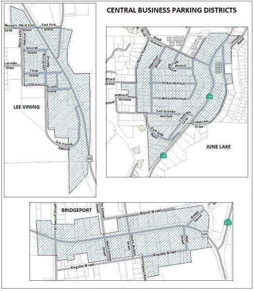
07.010 Intent.
07.020 Permitted signs.
07.030 Signs subject to Director Review.
07.040 General provisions.
07.050 Design excellence (optional).
07.060 Prohibitions.
07.070 Nonconforming signs.
07.010 Intent.
It is the intent of this chapter to establish sign standards that will enhance and preserve the unique scenic beauty of Mono County and promote pedestrian, bicycle, vehicle, and traffic safety. Thus, aesthetics and safety are the primary objective of the following sections. Signs shall be located to be compatible with their surroundings in terms of size, shape, color, texture and lighting. They should not compete visually with other signs. Because signs are important in providing information to the public and reducing hazards and confusion to pedestrians, bicyclists, and motorists, they should be simple in design and easy to read and should not obstruct vision from roadways or interfere with official traffic signs or signals.
Further, the provisions of applicable area plans will apply if more-restrictive regulations are contained therein. For example, a use permit is required for freestanding signs in a scenic highway corridor.
07.020 Permitted signs.
The following signs are permitted (some require a Building Division permit). These regulations, where more restrictive, override applicable building and/or other code requirements:
- Awning or Canopy Sign:
Definition: An awning sign is painted, stenciled, stitched, sewn or stained onto the exterior of an approved awning or canopy. Signs hanging from or attached to a canopy are not permitted under this definition (see Hanging Signs).
Requirements: No awning sign may have less than 8 feet of clearance from the bottom of the awning to the sidewalk. When an awning is the main signage for a business, the flap should be a minimum of 12 inches wide with 8-inch letters so that the sign can be easily read from across the street.
- Changeable Copy Sign (or Marquee):
Definition: A sign that contains removable letters (or uses electronically changing copy) and provides information that is subject to change. This includes amenities available for motels or resorts, movies at theaters, and current events at an auditorium.
Requirements: Maximum size permitted is 20 sq. ft. This sign area shall be counted against the overall sign area permitted for any corresponding monument/freestanding signs or attached/projecting signs on the subject parcel.
- Political Signs:
Definition: A sign that indicates or displays the name or picture of an individual seeking election or appointment to a public office or relates to a forthcoming public election or referendum or advocates a person's, group's or party's political views or policies.
Requirements:
- Political signs shall be posted only so long as needed to convey the message intended by the posting and shall be removed immediately thereafter.
- Political signs that have an adhesive backing shall not be affixed directly to any structure. Such a sign with adhesive backing shall first be affixed to a temporary backing of wood, paper or plastic for support that can be removed easily from its posted location.
- Real Estate Signs:
Definition: A sign that advertises the sale, rental or lease of property on which it is erected and maintained.
Requirements: A maximum of one sign per parcel is permitted and shall be removed within 15 days after the close of escrow or close of the rental/lease agreement. The sign must be located entirely within the subject property and shall not be lit. Maximum sign areas and heights shall be permitted as follows:
| Parcel Size | Sign Size | Sign Height | Minimum Setback from Edge of Road |
|---|---|---|---|
| 10 acres or smaller | 4 sq. ft. | 4' | 5' |
| 10 acres and larger | 12 sq. ft. | 8' | 20' |
- Projecting Signs:
Definition: A sign that projects outward perpendicularly or at an angle from a wall or building face and is primarily attached to that wall or building face.
Requirements: A projecting sign may not extend more than three feet from the wall or building face and not exceed 10 sq. ft. with a minimum clearance of eight feet from the bottom of the sign to the sidewalk. Additional bonus square footage may be awarded as specified in Section 07.050, Design excellence.
- Hanging Signs:
Definition: A hanging sign is similar to a projecting sign except that the primary sign face is hanging or suspended from a support bracket that projects outward from the wall or building face. A hanging sign may also hang from an awning.
Requirements: A hanging sign may not extend more than 4 feet from any building or wall face. It shall not exceed 10 sq. ft. with a minimum clearance of 8 feet from the bottom of the sign to the sidewalk. Additional square footage may be awarded as specified in Section 07.050, Design excellence.
- Residential Identification Sign: The following residential identification signs are allowed without permit approval:
- Private individual residence identification signs, limited to the names of the occupants and a total of 2 sq. ft. in size; and
- Multifamily projects, limited to one permanent identification sign with a maximum area of 20 sq. ft., attached to an approved wall or facade. Freestanding or monument signs are subject to Director Review as specified in this chapter. A total signing program will be required as part of the use permit requirements for any new multifamily residential project of four or more units. Additional square footage may be awarded as specified in Section 07.050, Design excellence.
- Safety or Required Signs:
- Signs required for the public safety and convenience shall be permitted in conjunction with permitted business identification signs and shall not be counted against the allowable identification sign area. Safety or required signs shall not exceed 3 sq. ft. in each sign area and may contain any combination of the following words or symbols: "Parking"; "Park Here"; "Customers Only"; "Open”; etc. and shall not contain the name of the business.
- Required signs include those mandated by a federal, state or local agency, and include display of gas prices by retail gasoline distributors. Gasoline price signs shall not exceed more than one set of signs per street frontage. Each line of letters or numbers cannot exceed 6 inches in height, and total sign area may not exceed 24 sq. ft.
- If the name or logo of the business appears integrated along with any safety or required sign, the total sign area shall be counted against the allowable sign area.
- Special Events and Holiday Signs:
Banners, signs or decorative materials are permitted in conjunction with a holiday season or an event conducted in accordance with Section 02.1080, Special Events. Such signs and decorative materials are not to be erected more than 30 days preceding the event and shall be removed upon its conclusion. Temporary signs in residentially designated areas shall be limited to garage sales and open-house signs, and shall be limited to 3 sq. ft. Political signs and signs displaying noncommercial messages are not subject to this paragraph.
- Window Signs:
Definition: Sign(s) painted on, attached to, designed or placed so as to be read principally through the windows from outside the business.
Requirements: The total of all permanent window signs shall cover no more than 20% of total window area. Temporary sales and special event signs may be displayed over this 20% maximum, but shall be removed immediately upon conclusion of the sale or special event, in no case to exceed 30 days.
- Building Identification and Directory Plaques:
Definition: A plaque mounted flush to a building to denote the building's identity, tenants or historical information. This sign shall not be counted against the allowable sign area.
Requirements: If the parking lot entrance and the main building entrance front on different streets, there may be one sign at each entrance. The total sign area shall be limited to a maximum size of 8 inches by 48 inches and letters shall not exceed 3 inches.
- Flags:
Definition: A rectangular piece of fabric or other flexible material that is used as a symbol, signage device, or decoration. Flag does not include temporary banners associated with special events or holidays, which are subject to regulation in accordance with paragraph I of this section.
Requirements: Flags displaying noncommercial messages (for example, flags of a nation, state, or local entity, or flags of a religious or civic organization), when not used as an advertising device (i.e., to promote a commercial transaction) shall be permitted. Flags displaying commercial messages or used as an advertising device (i.e., to promote a commercial transaction) shall be considered signs and shall be subject to regulation in accordance with the provisions of this chapter applicable to signs generally, based on the individual characteristics of the flag in question (e.g., freestanding, attached, hanging, etc.).
07.030 Signs subject to Director Review.
The following signs are subject to Director Review as specified in Chapter 31:
- Attached:
Definition: A sign mounted flush and affixed securely to a building wall that projects no more than 6 inches from the face of a building wall, and does not extend vertically or horizontally beyond the building.
Requirements:
- Attached signs may occupy 1 sq. ft. for each 2 lineal feet of business frontage upon which the sign is located. In intensive commercial and industrial areas (e.g., C, IP and I), the maximum area of any attached sign shall not exceed a 100 sq. ft., but need not be less than 25 sq. ft. In rural, agricultural, residential and neighborhood commercial areas, the maximum area of any attached sign shall not exceed 50 sq. ft., but need not be less than 15 sq. ft.
- When two or more separate businesses (located in separate offices, spaces, or buildings) are located on one parcel, each shall be eligible for at least the minimum square footage (i.e., 15 or 25 sq. ft.).
- Further, the maximum height of the sign shall be 20 feet or the height of the building, whichever is less. A maximum of two attached signs per occupancy is permitted, but in total combined area cannot exceed the maximum permitted. Additional square footage may be awarded as specified in Section .050, Design excellence.
- Community and Historical:
Definition: A sign erected by a Chamber of Commerce or similar organization that identifies local communities or points of historical interest.
Requirements: There are no specific square footage or height restrictions. However, such signs shall be visually compatible and shall not compete with the area in which they are placed. The sign may identify a city or unincorporated community and may contain the name, sub-name or slogan of the area, but without other advertising.
- Freestanding and Monument Signs: One freestanding or monument permitted for parcels with a minimum of 100 feet of street frontage. Shopping centers with 10 or more shops/offices may have one for each street frontage.
- Freestanding:
Definition: A sign anchored directly to the ground or primarily supported from the ground rather than a building.
Requirements: The maximum height of the sign shall be 20 feet or the height of the associated building, whichever is less. Freestanding signs may occupy 1 sq. ft. for every 3 lineal feet of street frontage, up to a maximum of 100 sq. ft. Freestanding signs shall be set back a minimum of 5 feet from the property line. Additional square footage may be awarded as specified in Section 7.050, Design Excellence.
- Monument:
Definition: A freestanding sign attached continuously at grade.
Requirements: The maximum height of monument signs shall be 8 feet. Monument signs are computed the same as freestanding signs (above), except that the minimum need not be less than 45 sq. ft. and the maximum cannot exceed 125 sq. ft. Additional square footage may be awarded as specified in Section 7.050, Design excellence.
- Directional:
Definition: A sign that provides needed directions to remotely located business and scenic, recreation areas such as pack stations, lodges, resorts and lakes.
Requirements: Directional signs will be approved only upon a demonstrated need. It will be limited to the name of the business or area, and direction to its location. Signs cannot exceed 3 sq. ft.
- Informational Kiosks and Freestanding Directory Boards:
The following sign types will be allowed only when submitted as part of a total signing program for a shopping center, community improvement district, etc.:
- Directory Boards: Provides information as to the location of businesses in a pedestrian-oriented business area, not to exceed 3 sq. ft. in area and, if hung, shall not be higher than 6 feet; and
- Kiosks: May provide information as to the location of businesses in a pedestrian-oriented business area, as well as a surface for handbills, posters and fliers to be affixed to. The total area of a kiosk display surface is not to exceed 40 sq. ft. or 8 feet in height. Kiosks are to be separated from adjacent structures by a minimum of 6 feet. Kiosks shall be maintained with a neat appearance and outdated materials shall be removed promptly.
07.040 General provisions.
The provisions of this section are applicable to all signs constructed or altered after the effective date of this chapter except as otherwise provided by this chapter. No person except a public officer or employee in the performance of a public duty shall paint, paste, display, construct, erect, alter, use or otherwise maintain any sign except in accordance with the provisions of this chapter.
- Sign Measurements:
- Area: The area of a sign is to be measured as the number of square feet of the smallest rectangle within which a single sign face can be enclosed, as follows:
- Sign Faces Counted: Where a sign has two faces containing sign copy that are oriented back-to-back, are separated by not more than 3 feet at any point, and are parallel to each other; the area of the sign is to be measured using the face of the larger sign;
- Wall-mounted Letters (channel letters): Where a sign is composed of letters individually mounted or painted on a building wall, without a border or decorative enclosure; the sign area is that of the smallest single rectangle within which all letters and words can be enclosed;
- V-Shaped Signs: The area of a V-shaped sign shall be calculated the same as if it were a single sign face; and
- Monument Signs: Area shall be calculated for that portion of the sign enclosed by the decorative border or frame and shall not include the foundation for the sign (however, the 8-foot height limit does include the foundation).
- Height: The height of a sign shall be measured as the vertical distance from the adjacent grade to the uppermost point on a sign or sign structure.
- Area: The area of a sign is to be measured as the number of square feet of the smallest rectangle within which a single sign face can be enclosed, as follows:
- Sign Illumination: For those signs to be lit, indirect illumination from a separate light source is required, with the exception of channel letters. Use of neon and internal lighting is prohibited unless integrated with an overall architectural or design theme and is subject to Director's approval. An indirectly illuminated sign is defined as any sign whose illumination is reflected from its source by the sign display surface to the viewer's eye, the source of light not being visible from the street or from abutting property.
- Sign Copy Changes: Any sign erected in conformance to the provisions of this chapter may be repainted, maintained, and the copy changed as long as there is no increase in existing sign area or the sign face relocated; otherwise, the sign will be considered as a new sign and shall be subject to all provisions of this chapter. Where the sign is not in conformity to the provisions of the chapter, any change shall be in accordance with the provisions of Section 07.060, Nonconforming Signs.
- Shopping Centers, Malls, Office Complexes and Multifamily Projects: Any new proposal requiring a use permit and containing more than four residential units or four shops/offices shall include a total signing program with its use permit application. This signing program shall include total number, size and type of signs proposed, as well as elevations illustrating proposed design and materials to ensure that the signage will be integrated into the project's planning and design.
07.050 Design excellence (optional).
Any sign permitted (except real estate, temporary, and safety, or permitted by Director Review, has the option to apply for additional sign area under the provisions of this section.
Depending upon the quality and design excellence of any new sign, as determined by the Director, additional sign area up to 25% over stated maximums may be awarded.
Factors to be considered in the design excellence of any proposed sign include method of construction and material, color, lighting, relationship of the sign to the building, and relationship of the sign to the community. These are described in more detail as follows:
- Materials and method of construction:
Materials and construction style should harmonize with the natural surroundings. Thus, wood and stone are encouraged, along with metal finishes that accent the county's mining past.
Wooden signs can be routed, carved or sandblasted to get the effect of raised letters. Raised letters can also be attached to a wooden signage band. These can also be metal or precast and molded. Paint can also be directly applied to a flat wooden signage band.
Metal signs can also be used effectively by applying raised letters as described above or on a metal band. Paint and lettering can be applied, although a galvanized or baked enamel finish is required to avoid rusting.
Signage can be painted directly on the facade of a building. The use of tile can also be applied onto the wall surface if stucco walls are used instead of wood.
Use of natural materials and landscaping is an effective way to soften and accent monument and freestanding signs.
- Colors and visibility:
Colors should relate to and complement the materials or paint scheme of the buildings, including accenting highlights and trim colors. The number of colors on any sign should be limited to three. This heightens readability (visibility); especially when one color is a dark hue, the second a medium hue, and the third a light accent color. These three combine to produce a highly legible sign. Additional colors only compete with one another. Fluorescent colors are not permitted.
- Relationship of the sign to the building:
The location and size of signs on any building should relate to the architecture of that particular structure. The sign should reinforce the existing features of the building by fitting them within other lines and shapes. Flat signs, parallel to the facade, are excellent because they do not compete with the building. Wall signs should complement one another in color and shape and, if possible, be located in the same position over storefronts. In pedestrian areas signs should be located to be visible to both motorist and pedestrian.
- Relationship of the sign to the community:
Signs should not be out of scale with the street or visually disruptive, and should be visible by both passing motorists and pedestrians. Where feasible, relate new signs to others on the block by aligning them with existing signs or other horizontal elements, such as molding bands above store windows. A sign should complement and reinforce a community's character, creating harmony without uniformity.
07.060 Prohibitions.
The following signs and sign types are prohibited:
- No sign shall exceed 20 feet in height.
- Animated signs, such as those that rotate, move, flash, reflect, blink or effect changes in hue or intensity of illumination.
- Portable signs, including but not limited to, trailer-mounted marquees and sandwich boards.
- Signs that project over any property line except into a public right of way with applicable agency permits or extend more than 4 feet from any building or wall except where such signs are an integral part of an approved canopy or awning.
- Signs placed above the eave line, except in the case of an A-frame building where no other option is available or where the theme or design of the building warrants such sign as determined by the Director.
- Vehicular-mounted freestanding signs.
- Off-site advertising signs or billboards.
- Signs that advertise a home occupation, unless permitted by Expanded Home Occupation permit.
- Modification of the location or size of any sign granted under the provisions of Section 07.030, Director Review. All modifications of such signs shall be reviewed by the Director.
- Use of neon or internal lighting unless in conformance to Section 07.040-B, Sign Illumination.
- Attachment of signs to utility poles or natural features, including trees and rocks, etc.
- Removal or pruning of trees within any public right of way to increase the visibility of any sign.
- Placement of private advertising signs on public property.
- Signs that interfere with, obstruct the view of, or may be confused with any authorized traffic sign or interfere with or obstruct driver, pedestrian, or bicyclist visibility from any street, road, or highway.
07.070 Nonconforming Signs.
Nonconforming signs are those that were in existence at the time of adoption of land development regulations that do not conform to the provisions of this chapter. Such signs may be continued as follows:
- Expansion. A nonconforming sign may not be increased in area or lighting intensity or moved from its location after the effective date of this chapter.
- Sign Copy. The advertising copy on a nonconforming sign may be changed except as provided by subsection A, expansion of nonconforming signs, of this section.
- Discontinued use. If the use of a building or land associated with a nonconforming sign is discontinued for six months or more, all signs shall thereafter conform to the provisions of this chapter. Where a business operates on a seasonal basis and for which there is an active Mono County business license, the provisions relating to discontinued use will not apply.
- If the size or configuration of a lot or building is changed by the subdivision of the property or by alterations, identification signs and outdoor advertising signs on the resulting properties shall be required to conform to the sign regulations applicable to the newly created lot or lots at the time the change becomes effective.
- Removal. If a nonconforming sign is removed for any reason other than those specified in subsection C and this section, all subsequent signs must conform to the provisions of this chapter.
- Destroyed Signs and Advertising Structures.
- If a nonconforming sign is destroyed or partially destroyed to the extent of 50% or more of the replacement cost of the total sign before destruction by fire, explosion or act of God, the destroyed sign may be replaced or reconstructed, provided that it is brought into conformity to all applicable requirements of this chapter.
- If a nonconforming sign is partially destroyed to less than 50% of its replacement cost, it may be restored to its former nonconforming status.
FIGURE 13: SIGN TYPES
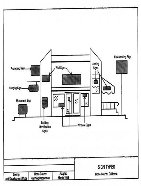
TABLE 07.010. SIGN STANDARD SUMMARY
| Sign Type | Maximum Number | Maximum Sign Size | Maximum Height | Level of Dept. Review | Designations Permitted | Other Standards |
|---|---|---|---|---|---|---|
| Awning | One per street or parking lot frontage | 10 sq. ft. | Minimum 8' ground clearance | Permitted with building permit |
ER, RR, RU, SP, AP C, SC |
|
| Changeable Copy/Marquee | One per business | 20 sq. ft. (counted against maximum allowed for freestanding or attached) | 20' | Permitted with building permit | C, SC | |
| Political | Not specified | Not specified | Not specified | Permitted |
All districts |
1. Must be removed when purpose for posting ceases. 2. If adhesive backing, affix to temporary backing. |
| Real Estate | One per parcel | 4 sq. ft. on parcel < 10 acres | 4' | Permitted | All districts |
1. Sign must be removed within 15 days of close of escrow. |
| 12 sq. ft. on parcels > 10 acres | 8' | |||||
| Projecting or | One per business (can be double-faced) | 10 sq. ft. | Minimum 8' ground clearance 20' | Permitted with building permit | ER, RR, RU, MFR, SP, C, SC, IP, I |
1. May not project more than 3’ from any wall |
| Hanging | One per business (can be double-faced) | 10 sq. ft. | Minimum 8' ground clearance 20' | Permitted with building permit | ER, RR, RU, MFR, SP, AP, C, SC, IP, I |
1. May not project more than 4’ from any wall |
| Window | Not specified | 20% of window area | Limited to first-floor windows | Permitted | All districts |
1. No maximum for sales or special event signs. |
| Director Plaque | One per building (two permitted if main entrance from both street and parking lot) | 8' X 48' | Not specified | Permitted | All districts | 1. Individual letters limited to 3" in height |
| Attached (wall) | Two per business |
a. Up to 20 sq. ft. in MFR, RU, SP, AP b. Up to 50 sq. ft. in ER, RR, IP Up to 100 sq. ft. in C, SC, I |
20' | Director Review | As specified under sign area |
1. Except for multifamily projects in MFR, RU, SP, AP districts, sign area is calculated at 1 sq. ft. for each 2 lineal feet of business frontage. 2. Cannot project more than 6" from building face. |
| Monument or | One per business (can be double-faced) | Up to 125 sq. ft. | 8' from grade | Director Review | ER, RR, MFR, SP, AP C, SC, IP, I |
1. Required a minimum of 100’ of street frontage. 2. Sign area is calculated at 1 sq. ft. per each 3’ of street frontage. |
| Freestanding | One per business (can be double-faced) | Up to 100 sq. ft. | 20' | Director Review | ER, RR, MFR, SP, AP C, SC, IP, I |
1. Required a minimum of 100’ of street frontage. 2. Sign area is calculated at 1 sq. ft. per each 3’ of street frontage. 3. Sign shall be set back a minimum of 20’ from the street. |
| Directional | One per business (can be double-faced) | 3 sq. ft. | Not specified | Director Review | All districts |
1. Must demonstrate need in order to erect |
NOTE: This summary is for informational purposes only. Refer to the applicable sections of Chapter 07 for detailed requirements.
- Eligible for additional square footage under the provisions of the Design Excellence Section 07.050.
- Noted signs are permitted in these districts only as part of a total signing program (see Sections 07.020 G2 and 07.040 D).
08.010 Applicability.
08.020 Establishment of district.
08.030 Standards – General.
08.040 Standards – State Scenic Highway 395
08.050 Uses permitted subject to Use Permit.
08.060 Uses permitted subject to Use Permit.
08.070 Permit Issuance.
08.010 Applicability.
The S-C, scenic combining, district is intended to regulate development activity in scenic areas outside communities in order to minimize potential visual impacts. Use of the S-C district is encouraged in areas adjacent to and visible from designated scenic highways as well as in other important scenic areas.
08.020 Establishment of district.
The S-C, scenic combining, district may be overlaid on any designation. In addition to the requirements of this chapter, initiation and application of the scenic combining district is subject to the same requirements as a land use redesignation (see Ch. 48, Amendments).
08.030 Standards – General.
- Development in the scenic combining district shall be restricted by the following general standards:
- Visually offensive land uses shall be adequately screened through the use of extensive site landscaping, fencing, and/or contour grading;
- Earthwork, grading and vegetative removals shall be minimized;
- All site disturbances shall be revegetated with plants and landscaping that are in harmony with the surrounding environment (drought-resistant indigenous plants are encouraged). A landscaping plan shall be submitted and approved for all projects;
- Existing access roads shall be utilized whenever possible. Construction of new access roads, frontage roads or driveways shall be avoided except where essential for health and safety;
- The number, type, size, height and design of on-site signs shall be strictly regulated according to the County sign regulations (see Ch. 07);
- The design, color and materials for buildings, fences and accessory structures shall be compatible with the natural setting;
- All new utilities shall be installed underground in accordance with Chapter 11, Development Standards – Utilities; and
- Exterior lighting shall be shielded and indirect and shall be minimized to that necessary for security and safety.
08.040 Standards – State Scenic Highway 395
New development outside communities visible from State Scenic Highway 395 shall be additionally restricted by the following standards:
- The natural topography of a site shall be maintained to the fullest extent possible. Earthwork, grading and vegetative removals shall be minimized. Existing access roads shall be utilized whenever possible. Existing trees and native ground cover should be protected. All site disturbances shall be revegetated and maintained with plants that blend with the surrounding natural environment, preferably local native plants;
- New structures shall be situated on the property where, to the extent feasible, they will be least visible from the state scenic highway. Structures shall be clustered when possible, leaving remaining areas in a natural state, or landscaped to be compatible with the scenic quality of the area;
- To the extent feasible new subdivisions shall not create parcels with ridgeline building pad locations;
- Roofs visible from State Scenic Highway 395 shall be a dull finish and in dark muted colors;
- Vertical surfaces of structures should not contrast and shall blend with the natural surroundings. Dark or neutral colors found in immediate surroundings are strongly encouraged for vertical surfaces and structures;
- Light sources in exterior lighting fixtures shall be shielded, down-directed and not visible from State Scenic Highway 395;
- Fencing and screening shall not contrast in color, shape and materials with the natural surroundings. The use of landscaping to screen utility areas and trash containers is strongly recommended; and
- Signs shall be compatible with the natural surroundings in color and shape. They shall be small in scale. No sign shall be placed or constructed in such a manner that it silhouettes against the sky above the ridgeline or blocks a scenic viewshed. The number, type, size, height and design of on-site signs shall be strictly regulated according to the County sign regulations.
08.050 Uses permitted.
All uses permitted in the basic land use designation with which the scenic combining district is combined shall be permitted.
08.060 Uses permitted subject to Use Permit.
All uses permitted in the basic land use designation with which the scenic combining district is combined shall be permitted, subject to securing a use permit.
08.070 Permit issuance.
The general standards listed in Section 8.03 shall be applied by the Planning Division during review of an application. No permit shall be issued until the project complies with the standards for this district.
09.010 Applicability.
09.020 Establishment of a design review district.
09.030 Design review process.
09.040 Standards - General.
09.050 Uses permitted.
09.060 Uses permitted subject to Use Permit.
09.070 Permit issuance.
09.080 Appeals.
09.010 Applicability.
This chapter provides for the establishment of design review districts and for design review of commercial structures and multifamily residential development within the district. Single-family residential development may also be reviewed if the ordinance establishing a design review district provides for such review.
09.020 Establishment of a design review district.
In addition to the requirements of this chapter, initiation and application of a design review district is subject to the requirements for a land use redesignation (see Ch. 48, Amendments). A design review district shall be established upon adoption of an ordinance that states the boundaries of the district and the purposes of the district.
09.030 Design review process.
Upon creation of a design review district, the board of supervisors may appoint a design review committee or may designate the Planning Division as the design review body for the purposes of this chapter. If a design review committee is appointed, the committee shall consist of not fewer than three or more than seven members residing within the design review district.
Specific design review standards shall be established for each design review district. These standards shall, at a minimum, comply with the general development standards in Section 9.040. Specific standards for a design review district shall be developed and updated as needed by the Planning Division in consultation with any local architectural review committee or, if appointed, by the design review committee, in consultation with the Planning Division and any local architectural review committee. Standards must be adopted by the board of supervisors in a noticed public hearing prior to review of any projects.
Either the Planning Division or, if appointed, the design review committee shall review an application for a project or permit to determine whether the proposal is compatible with the established design review standards for the district. In their review, the planning division or the design review committee shall identify unacceptable visual qualities of the proposal and request appropriate changes. Proposals may be recommended for approval by the design review committee with or without conditions; design review committee recommendations shall be considered by the Planning Division in the case of building permits or by the reviewing body prior to approval.
If an active local architectural review committee exists to enforce CC&Rs in a subdivision that lies within a design review district, that committee may continue to review all development applications within the subdivision.
09.040 Standards - General.
- The overall objective of design review shall be to retain a community's natural topography, vegetation and scenic beauty to the greatest extent possible.
- Visually offensive land uses shall be adequately screened through the use of extensive site landscaping, fencing, and/or contour grading.
- Earthwork, grading and vegetative removals shall be minimized.
- All site disturbances shall be revegetated with plants and landscaping in harmony with the surrounding environment (drought-resistant indigenous plants are encouraged). A landscaping plan shall be submitted and approved for all projects.
- Existing access roads shall be utilized whenever possible. Construction of new access roads, frontage roads or driveways shall be avoided except where essential for health and safety.
- The number, type, size, height and design of on-site signs shall be strictly regulated according to the County sign regulations (see Ch. 07, Development Standards–Signs).
- The design, color and materials for buildings, fences and accessory structures shall be compatible with the natural setting.
- The following architectural designs and features are considered detrimental to the general well-being of a community:
- Reflective materials;
- Excessive height and/or bulk;
- Standardized designs that are utilized to promote specific activities and that are not in harmony with the community atmosphere; and
- Architectural designs and features that are incongruous to the community and/or that significantly detract from the natural attractiveness of the community or its surroundings.
- All new utilities shall be installed underground in accordance with Ch. 11, Development Standards – Utilities.
- Exterior lighting shall be shielded and indirect and shall be minimized to that necessary for security and safety.
09.050 Uses permitted.
All uses permitted in the basic land use designation with which the design review district is combined shall be permitted.
09.060 Uses permitted subject to Use Permit.
All uses permitted in the basic land use designation with which the design review district is combined shall be permitted, subject to securing a use permit.
09.070 Permit issuance.
No permit shall be issued in any case where design review is required until the project complies with the established design review standards for the district.
09.080 Appeals.
Appeals of any design review decision shall be made in conformance to the provisions of Ch. 47, Appeals.
10.010 Intent.
10.020 Establishment of district.
10.030 Uses permitted.
10.040 Uses permitted subject to Use Permit.
10.050 Lot area/District area.
10.060 Special requirements.
10.070 Restrictions to use of an E-Overlay District.
10.010 Intent.
The equestrian overlay district is intended to provide for the superimposing of an equestrian district on all land use designations where single-family residences are permitted. The land use designation followed by the letter E (e.g., SFR-E) would indicate an equestrian district overlay providing for the keeping of large domestic animals for personal use subject to the minimum standards set forth in this district.
10.020 Establishment of district.
The equestrian district may be overlaid on any single-family residential district. In addition to the requirements of this chapter, initiation and application of this overlay district is subject to the same requirements as any land use redesignation (see Ch. 48, Amendments).
10.030 Uses permitted.
The following uses shall be permitted in the equestrian overlay district, plus such other uses as the Commission finds to be similar and not more obnoxious or detrimental to the public safety, health and welfare:
- All uses permitted in the basic land use designation with which the equestrian district is combined; and
- Where the principal use of the subject parcel is single-family residential, the keeping of horses or other large domesticated animals for personal use may be permitted. No commercial animal raising or keeping shall be allowed.
10.040 Uses permitted subject to Use Permit.
All uses permitted in the basic land use designation with which the equestrian overlay district is combined shall be permitted, subject to securing a use permit.
10.050 Lot area/District area.
- Minimum lot area.
For the keeping of one horse or other large domesticated animal, 15,000 sq. ft. Additional animals may be kept on a larger parcel, but shall not exceed one animal for each 10,000 sq. ft. of land area contained in the parcel.
- Minimum district area.
- Five acres;
- Any addition to an already established E-Overlay District shall be not less than one acre.
10.060 Special requirements.
- Animal confinement areas, including, but not limited to pens and corrals, shall be maintained in accordance with Mono County Environmental Health requirements. Confinement areas shall be maintained in a clean and orderly manner at all times. Accumulation of animal waste or other odor- or insect- producing materials shall not be permitted. No part of any animal confinement area shall be located closer than 50 feet to any dwelling with the exception of the animal owner's dwelling in which case the minimum distance may be 20 feet.
- Barns, stables and similar necessary buildings in the E overlay district may exceed the height limitations for accessory structures in the base designation, but in no case shall they exceed the heights permitted for primary dwellings in the base designation.
11.010 Placement of Utility Infrastructure.
11.020 Alternative Energy Systems.
11.010 Placement of Utility Infrastructure.
- Exemption for Regulated Public Utilities.
The provisions of this section shall not apply to distribution and transmission lines owned and operated as part of the statewide electrical network regulated by the California Public Utilities Commission (PUC). The authority for this exemption is set forth in the California Constitution, Article XII, Section 8, which vests exclusive regulatory authority over the distribution and transmission lines of these utilities in the California Public Utilities Commission. However, the County shall work with the PUC and applicant to cooperatively meet the standards set forth in Section F.
- Uses Permitted.
Underground facilities for the distribution of gas, water, sewer, telephone, television, communications and electricity shall be allowed in all designations.
- Definitions.
For the purposes of this section, the following definitions shall apply:
"Individual development" means an individual development project, such as a single-family residence and/or Accessory Dwelling Unit, a garage, a single commercial use, one apartment building, or similar uses. It does not mean a subdivision, land division, condominium development, or development of more than one detached unit at the same time.
"Overhead utility lines" means utility distribution lines and service laterals that are installed above ground, either overhead, in an above-ground conduit, or in some other manner.
"Subdivision" means the division of any unit or units of improved or unimproved land as further defined in Section 02.1520 and the Mono County Subdivision Ordinance.
“Utility” means gas, water, sewer, telephone, television, communications and electricity.
“Wireline” is a general term that is used to describe a connection to the Internet that is provided via hardwire, as in the case of DSL, cable, or fiber-based technologies.
- Utility Distribution Lines to Individual Development.
Utility distribution lines to an individual development shall be installed underground, unless the applicant has obtained a Director Review permit with Notice for overhead installation, in the manner specified in Chapter 31, Director Review Processing. For projects that require a use permit, the application for overhead utility lines shall be processed as part of the use permit application.
Prior to considering issuance of a permit, planning staff shall work with the applicant to site and design the project in a manner that avoids or minimizes the use and impact of overhead lines. Consideration should be given to combining lines and co-locating with other applicable facilities whenever possible.
In granting a permit for overhead utility lines, the Community Development director (Director) or the Planning Commission (Commission) shall make at least one of the following findings in addition to the required Director Review or Use Permit findings, and shall also require anticipated impacts from all the findings be avoided, minimized, or mitigated to the extent possible:
- The overhead line placement will not significantly disrupt the visual character of the area. In making this determination, the Director or the Commission shall consider the following:
- In areas without a number of existing overhead lines in the immediate vicinity, would overhead lines create the potential for a significant cumulative visual impact; i.e., would allowing an overhead line be likely to result in future requests for additional overhead lines in the area? If so, it may be determined that an overhead line will have a significant impact on the visual character of the area.
- Does the topography or vegetation in the area effectively screen the proposed lines? If so, then an additional line may not significantly disrupt the visual character of the area.
- Are there other potential alignments that would have less visual impact?
- Does the project reduce the overall number of overhead lines and poles in the area; are the lines co-located with existing facilities; and/or do design features such as height of lines, size, color, reflectivity, tension in line, or other features reduce visual impacts? If so, it may be determined that an overhead line will not have a significant impact on the visual character of the area.
The Director or the Commission may consider additional information pertaining to the visual character of the area that is deemed relevant to the application.
- The placement of utility lines above ground is environmentally preferable to underground placement and does not create public health and safety impacts. In making this determination, the Director or the Commission shall consider the following:
- Will underground placement disturb an environmentally sensitive area, including but not limited to the following: cultural resource sites, significant wildlife habitat or use areas, riparian or wetland areas, or shallow groundwater? If so, above-ground placement may be preferable;
- Will overhead placement cause impacts to sensitive species, such as the Bi-State Distinct Population Segment of Greater Sage-Grouse, or other environmental impacts? If so, above-ground placement may not be preferable, or perch deterrents and other mitigations may be required (see policies in the Conservation/Open Space Element);
- Will underground placement require disturbance of a waterway, including perennial, intermittent and seasonal streams? If so, above-ground placement may be preferable;
- Will underground placement increase the utility line's exposure to environmental hazards, such as flood hazards, fault hazards or liquefaction? If so, above-ground placement may be preferable;
- Are there other potential alignments that would avoid potential environmental impacts?; and
- Are there adequate provisions for long-term maintenance and fire-hazard mitigation? If so, above-ground placement may be acceptable.
The Director or the Commission may consider additional information pertaining to the environmental sensitivity of the area that is deemed relevant to the application.
- The installation of underground utilities would create an unreasonable financial hardship on the applicant due to the unique physical characteristics of the property. In making this determination, the Director or the Commission shall consider the following:
- Is the cost of the line to be installed excessive?
- Will the installation of underground utilities require trenching under a stream bed?
- Will the installation of underground utilities require unreasonable trenching or blasting through rock?
- Are there alternate alignments that would eliminate or significantly lessen the financial hardship?
The Director or the Commission may consider other site specific financial hardships deemed relevant to the application.
- The exclusive purpose of the overhead line is to serve an agricultural operation.
For the purposes of this section, agricultural operations are defined as use of the land for the production of food and fiber, including the growing of crops and grazing of livestock. Above-ground utility lines may be permitted for agricultural uses such as pumps and similar uses.
- Impacts to sensitive species, such as the Bi-State Distinct Population Segment of Greater Sage-Grouse shall be avoided, minimized, or mitigated consistent with policies in the Conservation/Open Space Element.
- Utility Distribution Lines for Subdivisions.
Utility distribution lines for all subdivisions and land divisions shall be installed underground, unless a specific hardship can be demonstrated (see #3 above). If a specific hardship can be demonstrated, overhead installation may be allowed subject to approval of a variance (see Ch. 33, Variance Processing).
Subdivisions may be required to underground the feeder distribution line to the subdivision. An assessment district, or a similar mechanism, may be established for this purpose as a condition of the tract map approval.
- Utility Distribution Lines for All Other Communication Infrastructure
All other types of utility distribution lines shall be installed underground, unless the applicant has obtained a Director Review Permit with Notice for overhead installation, in the manner specified in Chapter 31, Director Review Processing. For projects that require a use permit, the application for overhead utility lines shall be processed as part of the use permit application. Projects located in the County right of way shall also require an encroachment permit from the Public Works Department.
Prior to considering issuance of a permit, planning staff shall work with the applicant to site and design the project in a manner that avoids or minimizes the use and impact of overhead lines. Consideration should be given to combining lines and co-locating with other applicable facilities whenever possible. If overhead installation is necessary, all of the criteria in Section 11.010D 1-4 shall be evaluated to provide justification, at least one finding must be made, and anticipated impacts shall be avoided, minimized, or mitigated to the extent possible. In addition, the following requirements shall be applied:
- Within Scenic Highway corridors, a variance (see Ch. 33, Variance Processing) and/or deviation authorization from the California PUC is required prior to approval of overhead construction; and
- In County rights of way other than Scenic Highway corridors, a use permit must be obtained prior to allowing overhead construction.
- Use Permit.
Other utility (municipal, private, and if applicable, public utilities not regulated by the PUC) distribution lines, transmission lines and corridors, towers, electrical substations, repeater stations, pumping stations, and uses accessory thereto, including microwave facilities, may be allowed in all districts subject to first securing a use permit, in the manner specified in Chapter 32, Use Permit Processing.
- Exceptions.
In the event that any regulations of the Public Utilities Commission or any other agency of the state with jurisdiction over utilities conflicts with the provisions of land use designations and the land development regulations, the regulations of the state shall apply, to the extent that the same are conflicting.
- Locational Requirements.
Whether or not a utility is subject to any permitting requirements as delineated in subsections A to G, above, all new utility distribution lines, transmission lines, corridors, rights of way, towers, electrical substations, repeater stations, pumping stations, cell/communication towers and uses accessory thereto, including microwave facilities, shall comply with the policies of this General Plan and applicable area or specific plans.
- Cellular and Wireless Towers
Towers erected for the purposes of providing communications through wireless or cellular technologies are permitted in all land use designations subject to a use permit. These towers shall exhibit substantial compliance with the following, unless such substantial compliance would result in an effective prohibition of the provision of wireless communication facilities, or in unreasonable discrimination against a provider of wireless communication facilities, as defined in the Telecommunications Act of 1996, or in non-compliance with any other applicable federal laws: [12]
- Visual mitigations strategies included in the Mono County Design Guidelines;
- Cellular and wireless towers shall bond for the reclamation of the site in the event that the infrastructure has not been utilized for a period of three years. Infrastructure shall be removed within one year of abandonment;
- Towers shall be sited only when there is an identified service provider who has proved a need for the facility;
- Facilities shall be co-located to minimize the number of towers, and new sites shall include capacity for additional providers to utilize the facility;
- New sites shall reference the County’s inventory of shadow areas and coverage gaps, when available, and provide coverage maps/data demonstrating a reduction in areas without coverage;
- Height shall be mitigated by siting towers on high ground but below ridgelines or hilltops. The impacts of increased height through a proposed modification [18] shall also be evaluated. Heights greater than 60’ may be allowed in Public Facilities (PF) land use designations subject to the following use permit finding, but in no case shall the height exceed 80’:
- The additional height shall not result in substantial detrimental effects on the enjoyment and use of surrounding properties.
In addition, at least one of the two following findings must be made in the use permit, and in no case shall additional height be granted above the minimum necessary to provide for the finding:
- The increased tower height is necessary to provide line-of-sight and service coverage that significantly reduces shadow areas and coverage gaps as demonstrated by coverage maps/data; and/or
- The increased tower height is necessary to support multiple carriers on one tower with adequate line-of-sight and service coverage as demonstrated by coverage maps/data.
- Perch deterrents and other sensitive-species mitigations shall be required consistent with policies in the Conservation/Open Space Element; and
- Cell tower operators shall be required to verify compliance with the FCC’s RF Emission Standards.
- Installation of Conduit and Wireline Infrastructure
Conduit and wireline for the purposes of providing communications infrastructure are permitted in all land use designations, and shall be installed underground and co-located with existing facilities or utilize existing wireline unless a Director Review permit or Use Permit has been obtained. Projects located in the County right of way shall also require an encroachment permit from the Public Works Department. New conduit and wireline infrastructure shall be subject to the following requirements in addition to the applicable permit:
- Evidence of need for new conduit or wireline infrastructure shall be demonstrated. Applicants should reference the County’s communication infrastructure database, when available.
- New conduit in the County right of way shall contain tracer wire, or be mapped with GPS, or have accurate georeferenced as-built digital drawings, or be otherwise locatable using standard devices or means. Data must be submitted to the County at completion of construction.
- New wireline infrastructure shall be placed in existing underground conduit before installing new conduit or overhead lines. Overhead lines shall be subject to Section F.
- All new, large-scale, commercial underground infrastructure shall be filed with the Underground Service Alert (USA).
- Sites shall be reclaimed and all infrastructure removed within 180 days of abandonment or cessation of use.
- Commercial Communication Infrastructure on Private Property
- A Director Review permit (Ch. 31, Director Review Processing) must be secured prior to locating commercial communication infrastructure on private property for reasons other than personal consumption by the property residents.
11.020 Alternative Energy Systems.
Alternative Energy Systems are accessory uses that generate power for no less than 80% on-site consumption. Systems that generate power beyond this threshold for sale, or for off-site consumption, may be permitted through use permit.
- Solar Thermal and Solar Photovoltaic
Solar thermal and solar photovoltaic systems are permitted in accordance with the California Solar Rights Act, through the issuance of a ministerial building permit.
The systems must comply with all structural, plumbing and electrical requirements of the current version of the California Building Code.
Ground-mounted systems are considered structures for the purposes of determining setbacks and lot coverage.
- Wind Energy Systems
Wind systems are permitted in Mono County pursuant to Chapter 20.05 of the Mono County Code pertaining to Small Wind Energy Systems.
[12] E.g., Section 6409(a) of the Middle Class Tax Relief and Job Creation Act of 2012.
[18] Ibid.
12.010 Background.
12.020 Purpose and Intent.
12.030 Definitions.
12.040 Development Credits Program Provisions.
12.060 Clustering.
12.010 Background.
Agriculture is an important component of the Mono County economy and cultural identity. The landowners of two valleys in particular, Bridgeport and Hammil, have expressed a strong desire to preserve their agriculturally designated lands. In these regions, a development credit program was crafted in the 1980s that allocated a fixed number of development credits to each parcel of agriculturally designated land based upon the total acreage of the individual parcel, or the total aggregated acreage of each individual landowner. Historically a “ledger” of development credits was maintained by the Community Development Department. This ledger is no longer maintained, as the number of development credits is tracked for each parcel directly on the Land Use Designation maps. Previously, the Area Plans for Bridgeport and Hammil valleys have described the Development Credits program. This chapter was created during the 2013 General Plan Update to better organize information regarding the existing development credit program and facilitate expanded agriculture preservation policies.
12.020 Purpose and Intent.
The purpose of the Development Credits program is to:
- Implement the policies of the General Plan, including the area plans of the Hammil Valley, Bridgeport Valley and Bodie Hills.
- Encourage the continuation of agricultural production.
- Ensure the retention of parcels sized large enough for viable agricultural production by allowing a process to transfer the development potential of large parcels to smaller parcels, clustered in appropriate locations.
12.030 Definitions.
Development Credit: One development credit permits the construction of one single-family residence. Accessory Dwelling Units, pursuant to Chapter 16 of the Mono County Land Development Regulations, shall not be considered as a development credit.
Exclusive Agriculture: A land use designation given to a parcel that has no remaining development credits.
Cluster development: The concentration of detached single-family residences onto smaller lots than ordinarily permitted by the base designation, while not exceeding the permitted density for the total acreage being considered. This permits optimum use of the land; i.e., responding to site constraints by clustering away from the area of sensitivity or high agricultural value, yet not decreasing the allowable density.
12.040 Development Credits Program Provisions.
The following development credit program provisions are applicable to all Agriculture land use designations with the DC suffix on the Land Use Designation maps (see https://monomammoth.maps.arcgis.com).
- Residential Development
One development credit permits the construction of one single-family residence. Accessory Dwelling Units, pursuant to Chapter 16 of the Mono County Land Development Regulations, shall be permitted and shall not be considered as a development credit.
- Subdivision Potential
Development credits shall be considered in the subdivision process. Parcels with multiple development credits may, through the subdivision process, cluster parcels smaller than otherwise allowed by the land use designation in appropriate locations. The total number of development credits allocated to a parcel equals the total number of developable parcels that may be created.
- Minimum Parcel Size and Designation
- In the Bridgeport Valley and Bodie Hills, no parcel may be created less than one acre in size.
- In the Hammill Valley, no parcel may be created less than 10 acres in size.
Parcels created through the subdivision process that are less than the minimum allowed parcel size for the AG designation shall be redesignated with the RR designation.
- Farm Labor Housing
Exclusive farm labor housing is allowed without consideration of development credits on parcels that support ongoing agricultural operations.
- Exclusive Agriculture
- One Exclusive Agriculture parcel per map may be created through the subdivision process.
- Exclusive Agriculture parcels will be noted on the Land Use Designation maps at https://monomammoth.maps.arcgis.com as AG parcels with the EX suffix.
- Exclusive Agriculture parcels of 160 or more acres are permitted one single-family dwelling and one Accessory Dwelling Unit pursuant to Chapter 16 of the Mono County Land Development Regulations.
- Exclusive Agriculture parcels shall not be further subdivided, decreased in size by a lot line adjustment, or merged with nonexclusive agriculture parcels.
- Exclusive Agriculture parcels may be enlarged through lot line adjustment or merger only when the larger parcel will remain completely with the Exclusive Agriculture designation.
12.060 Clustering.
Wherever feasible, residential development shall occur on clustered parcels of the minimum parcel size allowed by each community. The location of the residential clusters shall be guided by the following policies:
- Adjacent to existing residential development (if feasible);
- A buffer may be required in consultation with adjacent agricultural landowners;
- Avoiding steep slopes and fault hazard areas;
- Avoiding wetlands and areas subject to flooding;
- Away from visually sensitive areas, such as ridgelines or along scenic highways;
- Minimizing impacts to wildlife including migrating deer, sage grouse, etc.;
- Minimizing impacts to cultural resource sites;
- Proximate to existing access and utilities (if feasible);
- On soils of sufficient structural and sanitary waste disposal capabilities.
- To avoid impacts to irrigated land; and
- On soils rated Class II or poorer by the Soil Conservation Service land use capability classifications.
15.010 Purpose and Intent.
15.020 Applicability.
15.030 Criteria for Applying RDS.
15.040 Use Permit Requirements.
15.050 Phasing Requirements.
15.060 Amendments.
15.070 Development Standards.
15.080 Reclamation Requirements.
15.090 Financial Assurances.
15.100 Inspections.
15.110 Administration.
15.120 Enforcement.
15.010 Purpose and Intent.
The intent of the Resource Development Standards (RDS) are to evaluate and, if appropriate, permit resource development projects in a manner that is consistent with the provisions of this General Plan, applicable area plans, and applicable state and federal laws, such as the Surface Mining and Reclamation Act of 1975 (SMARA). The RDS have been established to protect the environment and allow for the conditional development of on-site resources, including but not limited to, mineral resources, geothermal resources, wind and solar energy resources, hydropower resources, and timber resources.
15.020 Applicability.
The Resource Development Standards (RDS) may be applied only to areas with existing or proposed resource development activities. The establishment of RDS is also intended to encourage and facilitate public awareness concerning the potential for resource and energy-related activities in areas where significant resource deposits or energy-related resources have been identified.
In compliance with General Plan policies, commercial facilities such as mining operations, geothermal operations, small-scale hydroelectric generation facilities, wind and solar energy generation facilities and similar resource development activities may be permitted only in areas designated Resource Extraction (RE) and Public and Quasi-Public Facilities (PF). The Agriculture (AG), Resource Management (RM), Industrial (I), and Open Space (OS) designations may allow limited exploration activities subject to a use permit.
15.030 Criteria for Applying the RDS.
In applying the RDS to a specific site, one or more of the following criteria must be demonstrated to the satisfaction of the County:
- An active resource development project currently exists on the subject lands.
- The project qualifies under the "vesting" provisions as specified in the California Surface Mining and Reclamation Act (SMARA).
- It has been reasonably determined to the satisfaction of the County that potentially significant resources exist on the lands under consideration. This determination may be based on reports filed by a registered professional acceptable to the County, and funded by the applicant. In the case of surface mining operations, a mineral land classification report may be acceptable if filed in conjunction with a SMARA Reclamation Plan.
- In areas with conflicting resource values, it has been reasonably determined to the satisfaction of the County that the proposed resource development activity is the highest and best use of the land and is in full compliance with the General Plan.
15.040 Use Permit Requirements.
- Filing:
- Submittal: An application for a use permit shall be accompanied by the appropriate filing fee and shall be submitted to the Planning Division on forms provided by the department. Applications must be complete.
- Acceptance: An application for a use permit shall not be deemed complete or accepted for filing and the processing time limits shall not begin to run until the Planning Division accepts the application as complete.
- Procedure:
- Use Permit Processing: Within 30 days after receipt of a resource use permit application, the Planning Division shall review the application and shall notify the applicant or his designated representative, in writing, concerning any application deficiencies.
- Applications shall be deemed complete unless the applicant or his designated representative has been notified in writing that the application is incomplete prior to the expiration of the 30-day review period. Acceptance of the application as complete shall not constitute an indication of project approval.
- Complete applications shall be processed in accordance with the provisions of Chapter 19.38, Use Permits, and for surface mining operations, with the applicable provisions of SMARA.
- Non-Use of Permit: In conformance to Chapter 19.38, Use Permits, failure to commence diligent resource development activities within one year subsequent to permit issuance, or within the period determined by the Planning Commission, shall render the use permit null and void. Documentation that the operator has made every attempt to secure required permits at the state or federal level but that, despite due diligence, the permits have not yet been issued may serve to stay this requirement.
- Use Permit Processing: Within 30 days after receipt of a resource use permit application, the Planning Division shall review the application and shall notify the applicant or his designated representative, in writing, concerning any application deficiencies.
- Environmental Compliance:
Permits shall be processed in accordance with CEQA, the Mono County Environmental Handbook and General Plan policies. Common environmental documentation may be used for the exploratory and development permit stages of a project when consistent with CEQA. Permits shall contain conditions that assure compliance with CEQA and with applicable laws and regulations of Mono County and other agencies with jurisdiction.
- Monitoring:
In accordance with General Plan policies and CEQA requirements, when applicable, permits shall contain conditions for ongoing monitoring of operations. The Conservation/Open Space Element contains monitoring requirements for geothermal, mineral, biomass, solar, wind, and other renewable resource development.
15.050 Project Development–Phasing Requirements.
In compliance with General Plan policies, geothermal projects shall be developed in a phased manner. In addition to the phasing requirements listed below, energy resource projects shall comply with all phasing requirements in this General Plan (Conservation/Open Space Element, Energy Resource Policies)
- Phasing of Geothermal Projects.
Geothermal development shall be subject to the following phased permitting process:
- The "Geothermal Exploration Permit" shall regulate geothermal exploration and reservoir characterization activities. The primary purpose of the exploratory phase is to determine hydrologic, geologic and other relevant characteristics of the geothermal resource being considered for development. During the exploratory phase, the permittee shall develop sufficient data, to the satisfaction of the County, to determine whether there is a geothermal resource adequate to sustain the proposed development project.
- The "Geothermal Development Permit" shall regulate geothermal development, operations, termination of operations, site reclamation, and reserve monitoring. The purpose of the development phase is to regulate all geothermal development, including the siting and construction of facilities, conditions of operation, maintenance of roads and equipment, and to assure the protection of the environment.
- Phasing of Other Resource Development Activities.
Other resource development activities may be subject to a phased permitting process, depending on the nature of the resource and its development.
15.060 Amendments.
- Minor Amendments to an Approved Resource Development Permit.
- Minor amendment: Minor changes to an approved resource development permit may be approved by the Planning Division director in accordance with the following provisions.
- Processing: Requests for approval of a minor amendment shall be submitted on forms provided by the Planning Division along with the applicable fees. Within 30 days of receipt of such a request, the Director shall determine whether or not the application should be considered a minor amendment. The Director shall approve or deny the request and notify the applicant in writing within 10 days of his decision. The decision of the Director as to whether or not the request should be approved or denied shall be final, unless an appeal is filed. If it is determined that the request is not a minor amendment, the request may be processed as a major amendment.
- Requests for a minor amendment may be approved only if the Director is able to make all of the following findings:
- That the proposed change involves only minor changes in the siting or operations of the project and will not affect the basic character or implementation of the permit;
- No substantial adverse environmental damage, either on-site or off-site, will result from the proposed change and the proposed change is consistent with adopted environmental determinations; and
- That the proposed change will not be detrimental to the public health, safety and welfare and is compatible with the objectives and policies of this General Plan and applicable specific plans.
- Major Amendments to an Approved Resource Development Use Permit.
- Major amendment: Major amendments to approved resource development use permits may be approved by the Planning Commission subject to the following provisions.
- Processing: Applications for proposed amendments shall be submitted on forms provided by the Planning Division and shall include such data as may be required to complete an environmental assessment. Applications shall include the required filing fee, and shall be noticed and scheduled for public hearing before the Planning Commission in the same manner as the original permit submittal.
- Amendments may be approved by the Planning Commission only if all of the following findings can be made:
- The proposed amendments are necessary or desirable to assure a more practical recovery of the resource or to avoid multiple future disturbances of surface land or waters;
- No substantial adverse environmental damage, either on site or off site, will result from the proposed change and that the proposed change is consistent with adopted environmental determinations;
- The security required to be filed by the applicant with the County is adequate or additional security has been filed to guarantee compliance with the revised permit;
- The permit, as amended, will continue to meet the requirements of this chapter and will be conducted in conformity to all applicable laws, ordinances, and regulations of all agencies with jurisdiction over the resource development project; and
- The approval of the amendment will not be detrimental to the public health, safety, or welfare and is compatible with the objectives and policies of this General Plan, and applicable specific plans, the land use designation and approved end use of the site.
15.070 Development Standards.
The following minimum development standards shall apply to all projects unless amended through the Specific Plan process or a Variance is approved to deviate from these standards. Other standards or conditions identified during the use permit process may also apply.
- Lot Size and District Area.
The minimum lot size and district area shall be 40 acres or a quarter, quarter section, with the exception of patent and/or historical mining claims and "vested operations" that shall be considered on a case-by-case basis.
- Setbacks.
- No processing equipment or facilities shall be located, and no resource development shall occur within the following minimum horizontal setbacks:
- One hundred (100) feet from any interior public street or highway unless the Public Works director determines that a lesser distance would be acceptable;
- One hundred (100) feet from any exterior property line or lease area boundary;
- Five hundred (500) feet from any adjacent private dwelling, institution, school, or other building or location used for public assemblage; and
- No geothermal development located within the Hot Creek Buffer Zone shall occur within 500 feet on either side of a surface watercourse (as indicated by a solid or broken blue line on US Geological Survey 7.5- or 15-minute series topographic maps).
- No residential uses shall be located with the following minimum horizontal setbacks:
- Fifty (50) feet from any interior public street or highway unless the Public Works director determines that a lesser distance would be acceptable.
- Fifty (50) feet from any exterior property line.
- No processing equipment or facilities shall be located, and no resource development shall occur within the following minimum horizontal setbacks:
- Visual Impacts.
- Siting.
All resource development projects shall be sited, designed and operated to minimize impacts to the surrounding visual environment, in conformance to applicable provisions of this General Plan and the Mono County Code. The Conservation/Open Space Element contains policies relating to the siting of various types of energy resource projects.
- Screening.
Screening shall be required for uses that are contiguous to any residential or commercial district or use, for uses in scenic highway corridors or important visual areas, and for uses with an identified significant visual impact. Screening may be achieved through the use of siting, landscaping, fencing, painting, contour grading, constructed berms and/or other appropriate measures. If landscaping is chosen as a method of screening, a landscape plan shall be submitted as part of the use permit application (see 15.59, Landscape Plan Requirements).
- Lighting.
Exterior lighting shall be shielded and indirect and shall be minimized to that necessary for security and safety.
- Materials and Colors.
Materials for structures, fences, etc. should harmonize with the natural surroundings, whenever possible. Materials should be non-reflective or should be painted with a matte finish. Colors for structures, fences, etc. should blend into the natural surroundings, and darker colors are preferred.
- Erosion and Sediment Control.
- Siting.
All resource development projects shall be sited, designed and operated to minimize erosion and sediment transport, in conformance to applicable provisions of this General Plan, the Mono County Code, and applicable state and federal regulations. The Conservation/Open Space Element, Energy Resource section, contains policies relating to the siting of various types of energy resource projects.
Siting should minimize impacts to the natural landscape. Project design should encourage the joint use of facilities whenever possible in order to minimize disturbance to the natural environment. Access and construction roads should be located so that natural features are preserved and erosion is minimized.
- Site Disturbance.
Earthwork, grading, and vegetative removal shall be minimized. Existing access roads shall be used whenever possible. Construction of new access roads, frontage roads, or driveways shall be avoided except where essential for health and safety. Earthwork and grading shall be performed in accordance with the county Grading Ordinance.
- Revegetation.
Site disturbances shall be revegetated in conformance to the Reclamation Plan developed pursuant to the county Reclamation Ordinance.
- Drainage.
Drainage facilities shall be constructed and maintained in accordance with the county Grading Ordinance and with any applicable requirements of the Lahontan Regional Water Quality Control Board pertaining to waste discharge.
- Cultural Resources.
The applicant shall stop work and notify appropriate agencies and officials if archaeological evidence is encountered during construction or operations. No disturbance of an archaeological site shall be permitted until such time as the applicant hires a qualified consultant and an appropriate report is filed with the county Planning Division that identifies acceptable site mitigation measures, that shall then become conditions of the use permit and the reclamation plan (if applicable).
- Noise.
All resource development projects shall be sited, designed and operated to minimize noise impacts to the surrounding environment, in conformance to the applicable provisions of this General Plan (Noise Element) and the Mono County Code (Noise Ordinance).
- Air Quality.
All resource development projects shall be designed and operated in compliance with all requirements of the Great Basin Unified Air Pollution Control District and applicable provisions of this General Plan.
- Safety, including Hazardous Materials and Hazardous Waste.
All projects shall comply with applicable safety standards. Hazardous waste shall be maintained in conformance to the Mono County Integrated Waste Management Plan.
- Infrastructure Removal.
The reclamation of a resource development project may include removal of plants, outbuildings, roadways, pipelines, towers, and other related infrastructure constructed as part of the development project. Infrastructure removal may require bonding in order to guarantee the site is returned to predevelopment conditions and/or the approved end land use as contained in the project’s reclamation plan as required in section 15.080.
15.080 Reclamation Requirements.
Standards and procedures for the reclamation of resource development activities in Mono County are contained in the county Reclamation Ordinance (Ch. 35 of the land development regulations). All resource development projects must comply with the Reclamation Ordinance. Reclamation plans must be submitted as part of the use permit application.
15.090 Financial Assurances.
Financial assurance requirements for the reclamation of resource development activities in Mono County are contained in the county Reclamation Ordinance (Ch. 35 of the land development regulations). All resource development projects must comply with the financial assurance requirement.
15.100 Inspections.
- Requirements.
The use permit shall establish an inspection schedule for compliance with use permit conditions. Inspections shall occur at least once a year, but may occur more often depending on the nature of the project. The inspection schedule may change over the lifetime of the project. The annual inspection for mining operations shall coincide with the annual inspection required by SMARA.
The county Reclamation Ordinance establishes an inspection schedule for reclamation plans. The required inspections for compliance with use permit conditions and reclamation plan requirements should coincide.
- Procedure.
The operator shall file a request for annual inspection with the county Compliance Officer at least once in each calendar year. Requests for annual inspections shall be accompanied by the appropriate filing fee.
The Compliance Officer shall inspect or cause to be inspected the site within 30 working days of receipt of the application for inspection and the filing fee. Unless otherwise agreed, failure to inspect within 30 working days shall be deemed a finding that the resource development operation is in compliance with its use permit.
15.110 Administration.
- Appeals.
Appeals of any decision resulting from the requirements of this chapter may be made in conformance to the provisions of Chapter 19.42, Appeals.
- Fees.
Fees required in conjunction with the provisions of this chapter shall be established from time to time by the Board of Supervisors.
15.120 Enforcement.
- Enforcement.
The provisions of this chapter shall be enforced by the Planning Division, county Compliance Officer, or such other persons as may be designated by the Board of Supervisors. Enforcement of the provisions contained in this chapter shall be in accordance with applicable provisions of the Mono County Code.
- Right of Entry.
Whenever it becomes necessary to inspect resource development activities as provided in this chapter or to investigate complaints associated with resource development activities or to monitor conditions of approval as may be imposed on resource development activities, reasonable access to the project site shall be afforded by the operator in conformance to Chapter 1.08 of the Mono County Code. Authorized representatives of the County, upon presentation of appropriate credentials, shall have access to the site without advance notice.
16.010 Intent.
16.020 Definition.
16.030 Applicable Land Use Designations.
16.040 General Provisions.
16.050 Standards for Accessory Dwelling Units.
16.010 Intent.
The intent of this chapter is to allow for Accessory Dwelling Units in accordance with State law in order to provide additional affordable housing opportunities, including housing for the elderly in Mono County.
16.020 Definition.
"Accessory Dwelling Unit" (also referred to as "dependent," “Secondary Housing,” or "granny unit") means residential occupancy of a living unit located on the same parcel as the primary residential unit. It provides complete, independent living facilities for one or more persons including permanent provisions for living, sleeping, eating, cooking, and sanitation on the same parcel as the primary unit is situated. An Accessory Dwelling Unit shall meet the minimum regulations for an efficiency dwelling unit in the California Building Code.
The Accessory Dwelling Unit can be either attached to or detached from the primary residential unit but in either case shall have similar architectural elements as the primary unit (i.e., materials, textures, colors, etc.; see 16.050 G below). The Accessory Dwelling Unit shall be clearly subordinate to the primary unit.
Utilities that are installed for future expansion, such as stub outs that would allow a kitchen to be installed at a later date shall be considered as complete cooking facilities in accessory dwelling units. In units required by deed restriction, complete cooking facilities shall be installed resulting in a usable kitchen at final permit issuance, and interior access between attached units shall be no more than a single personnel door.
16.030 Applicable Land Use Designations.
An Accessory Dwelling Unit may be permitted in any land use designation that allows single-family residences as a permitted use or as allowed in Specific Plan (SP) areas subject to the General Provisions below.
16.040 General Provisions.
- On parcels less than 7,500 sq. ft. in net area, an attached Accessory Dwelling Unit not exceeding 500 sq. ft. in size may be permitted with a building permit.
- On parcels of 7,500 sq. ft. up to 10,000 sq. ft. in net area, an attached Accessory Dwelling Unit not exceeding 640 sq. ft. in size is allowed with a building permit. A detached Accessory Dwelling Unit not exceeding 640 sq. ft. may be permitted by application for a Director Review.
- On parcels of 10,000 sq. ft. up to one acre in net area, an Accessory Dwelling Unit not exceeding 640 sq. ft. in size (attached or detached) is allowed with a building permit.
- On parcels one acre or greater, an Accessory Dwelling Unit not exceeding 640 sq. ft. in size (attached or detached) is allowed with a building permit. In this same parcel size range, an Accessory Dwelling Unit exceeding 640 sq. ft. but not exceeding 1,400 sq. ft. in size (attached or detached) may be permitted by application for a Director Review. In this same parcel size range, an Accessory Dwelling Unit exceeding 1,400 sq. ft. may be permitted by application for a use permit.
- Square footage of Accessory Dwelling Units shall be calculated based on the exterior dimensions of the unit. All interior living space shall count toward the total square footage of the unit.
- Consistent with Government Code section 65852.2, ministerial reviews shall occur within 120 days after receiving an accessory dwelling unit application.
16.050 Standards for New Accessory Dwelling Units.
- All construction shall conform to the height, setback, lot coverage, fees (including school impact fees and fire district fees), snow storage, and other development requirements applicable to residential construction in the land use designation in which the property is located.
- If a well and/or septic system is/are to be utilized, a clearance letter shall be obtained from the Environmental Health director and shall accompany the building permit application (or if applicable, the Director Review or Use Permit application). For Accessory Dwelling Units that are served by a public water and/or sewer system, a letter from the serving entity that indicates adequate service shall be submitted as part of the application.
- One of the units on the parcel (either the primary unit or the Accessory Dwelling Unit) must be owner occupied.
- If the Accessory Dwelling Unit is 640 sq. ft. or less in size, one off-street parking space must be provided for the Accessory Dwelling Unit in addition to parking required for the primary unit. If the Accessory Dwelling Unit is larger than 640 square feet, two parking spaces must be provided for the Accessory Dwelling Unit in addition to parking required for the primary unit, if it contains two or more bedrooms. Parking shall be in accordance with Chapter 06 of the Mono County Land Use Element unless the following instances exist, in which case, no parking standards shall be imposed.
- The accessory dwelling unit is located within one-half mile of public transit.
- The accessory dwelling unit is located within an architecturally and historically significant historic district.
- The accessory dwelling unit is part of the existing primary residence or an existing accessory structure.
- When on-street parking permits are required but not offered to the occupant of the accessory dwelling unit.
- When there is a car-share vehicle located within one block of the accessory dwelling unit.
- Whether attached or detached, the Accessory Dwelling Unit shall be architecturally compatible with the primary residence. The Community Development Department shall determine the architectural compatibility of the structures and shall consider roofing, siding, trim, door and window frame colors; roofing, siding, trim, door, and window materials; roof slope and pitch; and wall articulation, roof line articulation, eaves, railings, chimneys, porches, and similar features; landscaping should also be considered in helping to make the units compatible. In addition, the Accessory Dwelling Unit shall be clearly subordinate to the primary unit in terms of size and placement on the property. If attached, the two units shall have the appearance of a single-family residence; the Accessory Dwelling Unit entrance shall be located on the side or rear of the building.
- Accessory dwelling units shall not be required to provide fire sprinklers if they are not required for the primary residence. Accessory dwelling unit utility connections and related fees shall comply with Government Code section 65852.2.
- No passageway shall be required in conjunction with with the construction of an accessory dwelling unit. No setback shall be required for an existing garage that is converted to an accessory dwelling unit, and a setback of no more than five feet from the side and rear lot lines shall be required for an accessory dwelling unit that is constructed above a garage.
17.010 Requirements generally.
17.020 Lot area and lot width.
17.030 Density.
17.040 Existing mobile-home parks and recreational-vehicle parks.
17.050 Streets.
17.060 Garbage collection area.
17.070 Fences, landscaping and screening.
17.080 Access.
17.090 Yards.
17.100 Signs.
17.010 Requirements generally.
The standards contained in this chapter shall apply to the development of all mobile- home parks and recreational-vehicle parks in all designations. Refer to definitions 02.790 and 02.970 for the definition of mobile home and recreational vehicle.
17.020 Lot area and lot width.
- The minimum lot area in all designations shall be as follows but may be more restrictive in any applicable area of the General Plan:
Mobile-home parks, five acres;
Recreational-vehicle parks, two acres.
- The minimum lot width in all designations shall be:
Mobile-home parks, 250 feet;
Recreational-vehicle parks, 100 feet.
17.030 Density.
The maximum density permitted in all districts shall be as follows, but may be more restrictive in any area plan:
- Mobile-home parks, not more than 10 mobile-home spaces for each one acre of land area; and
- Recreational-vehicle parks, not more than seventeen (17) recreational-vehicle spaces for each one acre of land.
17.040 Existing mobile-home parks and recreational-vehicle parks.
The following standards shall apply to all existing mobile-home parks and recreational-vehicle parks that were legally established prior to adoption of the land use designations and land development regulations.
- Lot Area and Width.
- Any existing mobile-home park or recreational-vehicle park legally established prior to adoption of the land development regulations and that has a lot area or lot dimensions of less than prescribed by the designation in which it is situated is deemed a nonconforming lot and shall be permitted to continue the mobile-home park use. A mobile-home park on a nonconforming lot may, upon securing a use permit, expand to utilize the entire nonconforming parcel.
- Mixed Uses - Nonconforming lots.
- Subject to securing a use permit, a portion of a mobile-home park may be designated for use by recreational-vehicle spaces.
- Subject to securing a use permit, a portion of a recreational-vehicle park may be converted for use by mobile-home spaces subject to the following criteria:
- Any percent of the lot area may be converted to mobile-home uses; however, mobile-home areas shall be distinct from areas designated for recreational vehicles (i.e., separated by a road, fence or landscaped buffer).
- When converting recreational-vehicle spaces for mobile-home occupation, the converted space shall comply with all minimum yard requirements in section 17.090.
- All mobile-home spaces so created shall meet all State and County requirements for mobile-home installation.
17.050 Streets.
The following street-width standards shall apply to all internal streets for new parks or additions to existing parks. In those portions of the county that lie at an elevation of 7,000 feet and above, internal streets shall be widened an additional 5 feet over allowable minimums to facilitate snow removal. The more restrictive of these regulations, fire district, or Cal Fire standards shall apply.
- Recreational-Vehicle Parks.
- One Way: 15 feet. One-way streets shall be permitted only when individual recreational-vehicle sites are designed so that the vehicle can pull out (not back out) into the correct one-way direction.
- Two Way: 25 feet.
- Parking: Parking along internal roadways is allowed only when a paved or graveled parking lane 8 feet wide is provided in addition to the roadway.
- Mobile-Home Parks.
- Two Way: 25 feet.
- Parking on one side of the street: 33 feet.
- Parking on both sides of the street: 41 feet.
17.060 Garbage collection area.
All trash and garbage collection areas shall be surrounded on at least three sides by a solid fence not less than 5 feet in height.
17.070 Fences, landscaping and screening.
Upon a finding by the Planning Commission during the use permit process that a mobile-home park or recreational-vehicle park will have a detrimental impact upon surrounding properties, the Commission may determine that a solid fence of not less than 7 feet in height shall be placed and maintained on all side and rear property lines to mitigate the impact upon adjoining properties. Alternately, a combination of landscaping, screening or fencing also may be deemed appropriate.
17.080 Access.
All mobile home- and recreational-vehicle park spaces shall be served by internal streets within the development. There shall be no direct access from a mobile home- or recreational-vehicle space to a public street or road. All points of vehicular access to or from a public street or road shall be approved by the Public Works Department.
17.090 Yards.
- Yards from property boundaries.
- Front yard. A minimum 20-foot front yard.
- Rear yard. A minimum 10-foot rear yard.
- Side yard. A minimum 5-foot side yard.
- Yards from individual space boundaries.
- No mobile home shall have a front-yard setback of less than 10 feet from an interior street.
- No mobile home shall have a side yard of less than 5 feet along the entire length of the unit, and not less than 3 feet from any convenience structure or awning.
- No mobile home shall have a rear yard of less than 10 feet.
17.100 Signs.
- Not more than one sign shall be permitted at each entrance to a mobile-home park or recreational-vehicle park.
- The signs shall not exceed 32 sq. ft. in area, and shall not exceed 6 feet in height.
- Signs shall not be blinking, flashing, rotating or animated. Lights used to illuminate on the sign and to minimize glare on any public street or adjacent property.
- Each sign shall be placed adjacent to, but not closer than 10 feet to, the entrance from any public street or road serving the mobile-home park or recreational-vehicle park.
18.010 Purpose and intent.
18.020 Designations in which permitted.
18.030 Density.
18.040 Lot area/District area & width.
18.050 Special requirements.
18.060 Lot dimensions.
18.070 Yards.
18.080 Lot coverage.
18.090 Fences, screening and landscaping.
18.100 Access.
18.110 Accessory uses and structures permitted.
18.120 Undergrounding.
18.130 Subdivision of existing mobile-home parks, additional requirements.
18.010 Purpose and intent.
Since, historically, manufactured housing tends to be less expensive than conventional housing, it is the purpose and intent of this chapter to facilitate lower-cost housing opportunities by providing affordable-housing sites.
18.020 Designations in which permitted.
Manufactured housing subdivisions may be allowed, subject to a use permit and Tract Map application in the following land use designations: ER, MU, MFR, RMH, RR and SFR.
18.030 Density.
The maximum density permitted in all designations shall not be more than six housing lots designed for a single home for each one acre of land.
18.040 Lot area/District area and width.
The minimum lot area for each home shall be 4,000 sq. ft.
The minimum area requirements for a manufactured housing subdivision shall not be less than 5 acres; minimum lot width for the subdivision shall not be less than 250 feet.
18.050 Recreation / Open Space
Recreation or open space shall be provided for each manufactured-housing subdivision, the area of which shall be not less than 1,000 sq. ft. plus an additional 150 sq. ft. for each manufactured housing lot over eight. This open space may be in more than one location, but no location shall contain less than 1,000 sq. ft. Each recreational or open space shall be accessible to all of the manufactured housing lots in the facility and shall not be used for any other purpose.
18.060 Lot dimensions.
The minimum lot dimensions for each manufactured home shall be as follows:
Width, 50 feet; and
Depth, 80 feet.
18.070 Yards.
- Front yards. Each manufactured housing lot shall have a front-yard setback of not less than 10 feet extending the entire width of the manufactured housing lot. A front yard will be measured from the nearest element of the housing unit, or any accessory structure, to the closest edge of the interior access drive.
- Side yards. Each manufactured housing lot shall have a side yard of not less than 5 feet in width along the entire length of the housing unit,
- Corner lots. The side yard abutting the street shall be not less than 10 feet along the entire length of the manufactured housing unit and not less than 5 feet from the property line to any convenience structure or awning.
- Rear yards. Each manufactured housing lot shall have a rear yard of not less than 10 feet and shall extend across the entire width of the manufactured housing lot.
- No housing unit shall be located closer than 20 feet from any property line that is a public street.
18.080 Lot Coverage.
Not more than 75% of the area of a manufactured housing lot shall be covered by the housing unit, accessory structures, paved drives and parking.
18.090 Fences, screening and landscaping.
A solid fence of not less than 6 feet in height may be required on all exterior subdivision boundaries. Fences are permitted, but not required for manufactured housing lots, and shall not exceed 7 feet in height. Where a fence is located in any required front yard, it shall not exceed 4 feet. Alternately, a combination of landscaping, screening, or fencing may also be deemed appropriate.
18.100 Access.
All manufactured housing lots and recreation facilities shall have access only from a private interior drive. There shall be no direct access from a manufactured housing lot to a public street or road. Private internal access shall comply with standards of Chapter 22 Fire Safe Regulations.
18.110 Accessory uses and structures permitted.
The following accessory uses and structures may be permitted in manufactured housing subdivisions, provided that they conform to setback requirements and maximum lot coverage requirements:
- Convenience Structures. Awnings; portable, demountable, or permanent cabanas; storage cabinets and buildings; ramadas; windbreaks; carports; garages; porches; greenhouses; bathhouses and other accessory structures;
- Recreational Facilities. Parks, playgrounds, riding and hiking trails, golf courses, lakes, stables and riding rings, recreational buildings, clubhouses, community centers, and similar uses and facilities, provided that all such uses and facilities are designed for and limited to use by residents of the manufactured-housing subdivision and their guests, and if otherwise permitted by County Code.
18.120 Underground installation.
All sewer and water facilities and electric, gas, telephone, and TV cable distribution systems shall be placed underground.
18.130 Subdivision of existing manufactured home parks, additional requirements.
A manufactured-home park may be subdivided in accordance with applicable provisions of the Mono County Code relating to subdivisions and shall also comply with the provisions contained in this chapter, as well as in the provisions of Chapter 17 of the Mono County Code (Subdivision).
19.010 Findings.
19.020 Legislative purpose.
19.030 Definitions.
19.040 Minimum proximity requirements.
19.050 Permit required.
19.060 Severability.
19.010 Findings.
- The Board of Supervisors, in adopting this chapter, takes legislative notice of the existence and content of the following studies concerning the adverse secondary effects of Adult-Oriented Businesses in other cities: Garden Grove, California (1991); Tucson, Arizona (1990); Seattle, Washington (1989); Austin, Texas (1986); Oklahoma City, Oklahoma (1986); Indianapolis, Indiana (1984); Houston, Texas (1983); Beaumont, Texas (1982); Minneapolis, Minnesota (1980); Phoenix, Arizona (1979); Whittier, California (1978); Amarillo, Texas (1977); Cleveland, Ohio (1977); Los Angeles, California (1977). The Board of Supervisors finds that these studies are relevant to the problems addressed by the County in enacting this chapter to regulate the adverse secondary effects of Adult-Oriented Businesses, and more specifically finds that these studies provide convincing evidence that:
- Adult-Oriented Businesses are linked to increases in the crime rates in those areas in which they are located and in surrounding areas.
- Both the proximity of Adult-Oriented Businesses to sensitive land uses and the concentration of Adult-Oriented Businesses tend to result in blight and deterioration of the areas in which they are located.
- The proximity and concentration of Adult-Oriented Businesses adjacent to residential, recreational, religious, community or educational uses can have adverse secondary effects on local businesses and residences.
- There is substantial evidence that an increase in crime tends to accompany, concentrate around, and be aggravated by Adult-Oriented Businesses, including but not limited to an increase in the crimes of narcotics distribution and use, prostitution, pandering, and violence against persons and property. The studies from other cities establish convincing evidence that Adult-Oriented Businesses that are not regulated as to permissible locations often have a deleterious effect on nearby businesses in residential areas, causing, among other adverse secondary effects, an increase in crime and a decrease in property values.
- Based on the foregoing, the Board of Supervisors of Mono County finds and determines that special regulation of Adult-Oriented Businesses is necessary to ensure that their adverse secondary side effects will not contribute to an increase in crime rates or to the blighting or deterioration of the areas in which they are located or surrounding areas. The need for such special regulations is based upon the recognition that Adult-Oriented Businesses have serious objectionable operational characteristics, when located in direct proximity to sensitive uses such as dwellings, parks, schools, churches, or public buildings thereby having a deleterious effect upon the adjacent areas. It is the purpose and intent of these special regulations to prevent such adverse secondary effects.
- Mono County is a rural county that is made up mostly (at least 94%) of public lands over which the County lacks land use authority. Very little private land exists within the county and, of that private land, only a small portion (less than 1%) is available for any type of commercial use. Based on the above, and on a thorough review of decisions of the United States Supreme Court, the United States Court of Appeals for the 9th Circuit and California Courts, the Board finds that the locational requirements established by this chapter do not unreasonably restrict the establishment or operation of constitutionally protected Adult-Oriented Businesses in Mono County, and a sufficient reasonable number of appropriate locations for Adult-Oriented Businesses are provided by this chapter.
- In developing this chapter, the Board of Supervisors has been mindful of legal principles relating to regulation of Adult-Oriented Businesses and does not intend to suppress or infringe upon any expressive activities protected by the First Amendments of the United States and California Constitutions, but instead desires to enact reasonable time, place, and manner regulations that address the adverse secondary effects of Adult-Oriented Businesses. The Board of Supervisors has considered decisions of the United States Supreme Court regarding local regulation of Adult-Oriented Businesses, including but not limited to: City of Erie v. Pap’s A.M., 12 S.Ct. 1382 (2000); Young v. American Mini Theaters, Inc., 427 US 50 (1976) (Reh. denied 429 U.S. 873); Renton v. Playtime Theaters, 475 U.S. 41 (1986) (Reh. denied 475 U.S. 1132); FW/PBS, Inc. v. Dallas, 493 U.S. 215 (1990); Barnes v. Glenn Theater, 501 U.S. 560 (1991); United States Court of Appeals 9th Circuit decisions, including but not limited to: Diamond v. City of Taft, 2000 WL 821287 (9th Cir. (Cal.)); Topanga Press, et al. v. City of Los Angeles, 989 F.2d 1524 (1993); Kev, Inc. v. Kitsap County, 793 F.2d 1053 (9th Cir. 1986); Colacurcio v. City of Kent, 163 F.3d 545 (9th Cir. 1998), pet. For cert. Filed (1999); several California cases including but not limited to: Tily B. v. City of Newport Beach, 69 Cal.App.4th 1 (1998); City of National City v. Wiener, 3 Cal.4th 832 (1993); People v. Superior Court (Lucero) 49 Cal.3d 14 (1989); and City of Vallejo v. Adult Books, et al., 167 Cal.App.3d 1169 (1985); and other federal cases including Lakeland Lounge v. City of Jacksonville (5th Cir. 1992) 973 F.2d 1255, Hang On, Inc. v. Arlington (5th Cir. 1995) 65 F.3d 1248, Mitchell v. Commission on Adult Entertainment (3rd Cir. 1993) 10 F.3d 123, International Eateries v. Broward County (11th Cir. 1991) 941 F.2d 1157, and Star Satellite v. City of Biloxi (5th Cir. 1986) 779 F.2d 1074.
- General plans, licensing and other police power regulations are legitimate, reasonable means of accountability to help protect the quality of life in Mono County and to help assure that all operators of Adult-Oriented Businesses comply with reasonable regulations and are located in places that minimize the adverse secondary effects that naturally accompany the operation of such businesses.
- The Board of Supervisors recognizes the possible harmful effects on children and minors exposed to the effects of such Adult-Oriented Businesses and the deterioration of respect for family values, and the need and desire of children and minors to stay away from and avoid such businesses, which causes children to be fearful and cautious when walking through or visiting the immediate neighborhood of such businesses; and the particular need to reduce such effects near schools, where large numbers of children spend much of their time; and the Board of Supervisors desires to minimize and control the adverse secondary side effects associated with the operation of Adult-Oriented Businesses and thereby protect the health, safety, and welfare of the citizens of Mono County; protect the citizens from increased crime; preserve the quality of life; preserve property values and the character of surrounding neighborhoods and businesses; deter the spread of urban blight and protect against the threat to health from the spread of communicable and sexually transmitted diseases.
- It is not the intent of the Board of Supervisors in enacting this chapter, or any provision thereof, to condone or legitimize the distribution of obscene material, and the County recognizes that State law prohibits the distribution of the obscene materials and expects and encourages law enforcement officials to enforce state obscenity statutes against such illegal activities in Mono County.
- Nothing in this chapter is intended to authorize, legalize, or permit the establishment, operation, or maintenance of any business, building, or use that violates any County ordinance or any statute of the State of California regarding public nuisances, unlawful or indecent exposure, sexual conduct, lewdness, obscene or harmful matter or the exhibition or public display thereof.
- While the Board of Supervisors desires to protect the rights conferred on Adult-Oriented Businesses by the United States Constitution, it does so in a manner that ensures the continued and orderly development of property within the county and diminishes, to the greatest extent feasible, those undesirable secondary effects that the aforementioned studies have shown to be associated with the development and operation of Adult-Oriented Businesses.
- Adult-Oriented Businesses are linked to increases in the crime rates in those areas in which they are located and in surrounding areas.
19.020 Legislative purpose.
It is the intent of the chapter to prevent community-wide adverse economic impacts, increased crime, decreased property values, and the deterioration of neighborhoods that can be brought about by the location of Adult-Oriented Businesses in close proximity to incompatible uses such as schools for minors, churches, parks, public buildings and residentially designated districts or uses. It is the purpose of this chapter to establish reasonable and uniform regulations to prevent the location of Adult-Oriented Businesses in close proximity to incompatible uses, while permitting the location of Adult-Oriented Businesses in certain areas.
19.030 Definitions.
For the purpose of this chapter the words and phrases shall have the same meanings respectively ascribed to them by this section and by Chapter 02 of the Land Development Regulations set forth in Section VI of this General Plan Land Use Element:
“Adult-Oriented Businesses.” The term "Adult-Oriented Businesses" as used in this chapter means any one of the following:
- Adult Arcade. The term "adult arcade" as used in this chapter means an establishment where, for any form of consideration, one or more still or motion picture projectors, or similar machines, for viewing by five or fewer persons each, are used to show films, computer generated images, motion pictures, video cassettes, slides or other photographic reproductions 30% or more of the number of which are distinguished or characterized by an emphasis upon the depiction or description of specified sexual activities or specified anatomical areas.
- Adult Bookstore. The term "adult bookstore" as used in this chapter means an establishment that has 30% or more of its stock in books, magazines, periodicals or other printed matter, or of photographs, films, motion pictures, video cassettes, slides, tapes, records or other form of visual or audio representations that are distinguished or characterized by an emphasis upon the depiction or description of specified sexual activities and/or specified anatomical areas.
- Adult Cabaret. The term "adult cabaret" as used in this chapter means a nightclub, bar, restaurant, or similar business establishment that: 1) regularly features live performances that are distinguished or characterized by an emphasis upon the display of specified anatomical areas or specified sexual activities; and/or 2) that regularly features persons who appear semi-nude; and/or 3) shows films, computer generated images, motion pictures, video cassettes, slides, or other photographic reproductions 30% or more of the number of which are distinguished or characterized by an emphasis upon the depiction or description of specified sexual activities or specified anatomical areas.
- Adult Hotel/Motel. The term "adult hotel/motel" as used in this chapter means a hotel or motel or similar business establishment offering public accommodations for any form of consideration that: 1) provides patrons with closed-circuit television transmissions, films, computer generated images, motion pictures, video cassettes, slides, or other photographic reproductions 30% or more of the number of which are distinguished or characterized by an emphasis upon the depiction or description of specified sexual activities or specified anatomical areas; and 2) rents, leases, or lets any room for less than a six-hour period, or rents, leases, or lets any single room more than twice in a 24-hour period.
- Adult Motion Picture Theater. The term "adult motion picture theater" as used in this chapter is a business establishment where, for any form of consideration, films, computer generated images, motion pictures, video cassettes, slides or similar photographic reproductions are shown, and 30% or more of the number of which are distinguished or characterized by an emphasis upon the depiction or description of specified sexual activities or specified anatomical areas.
- Adult Theater. The term "adult theater" as used in this chapter means a theater, concert hall, auditorium, or similar establishment that, for any form of consideration regularly features live performances that are distinguished or characterized by an emphasis on the display of specified anatomical areas or specified sexual activities.
- Modeling Studio. The term "modeling studio" as used in this chapter means a business that provides, for pecuniary compensation, monetary or other consideration, hire or reward, figure models who, for the purposes of sexual stimulation of patrons, display "specified anatomical areas" to be observed, sketched, photographed, painted, sculpted or otherwise depicted by persons paying such consideration. "Modeling studio" does not include schools maintained pursuant to standards set by the state Board of Education. "Modeling studio" further does not include a studio or similar facility owned, operated, or maintained by an individual artist or group of artists, and that does not provide, permit, or make available "specified sexual activities."
“Adult-Oriented Business Operator” The term "Adult-Oriented Business Operator" as used in this chapter (hereinafter "operator") means a person who supervises, manages, inspects, directs, organizes, controls or in any other way is responsible for or in charge of the premises of an Adult-Oriented Business or the conduct or activities occurring on the premises thereof.
“Applicant” The term “applicant” as used in this chapter is a person who is required to file an application for a permit under this chapter, including an individual owner, managing partner, officer of a corporation, or any other operator, manager, employee, or agent of an Adult-Oriented Business.
“Church” The term "church" as used in this chapter is a structure used primarily for religious worship and related religious activities.
“Community Development Director” The term “Community Development Director” as used in this chapter shall mean the Community Development Director of Mono County or the authorized representatives thereof.
“Distinguished or Characterized by an Emphasis Upon” As used in this chapter, the term "distinguished or characterized by an emphasis upon" shall mean and refer to the dominant or essential theme of the object described by such phrase. For instance, when the phrase refers to films "which are distinguished or characterized by an emphasis upon" the depiction or description of specified sexual activities or specified anatomical areas, the films so described are those whose dominant or predominant character and theme are the depiction of the enumerated sexual activities or anatomical areas. See Pringle v. City of Covina, 115 Cal.App.3 151 (1981).
“Establishment of an Adult-Oriented Business” As used in this chapter, to establish an Adult-Oriented Business shall mean and include any of the following.
- The opening or commencement of any Adult-Oriented Business as a new business;
- The conversion of an existing business, whether or not an Adult-Oriented Business, to any Adult-Oriented Businesses defined herein;
- The addition of any of the Adult-Oriented Businesses defined herein to any other existing Adult-Oriented Business; or
- The relocation of any such Adult-Oriented Business.
“Figure Model” The term "figure model" as used in this chapter, means any person who, for pecuniary compensation, consideration, hire or reward, poses in a modeling studio to be observed, sketched, painted, drawn, sculptured, photographed or otherwise depicted.
“Health Officer” The term “Health Officer” as used in this chapter means the Mono county Health Officer or his or her duly authorized representative.
“Nudity or a State of Nudity” The term "nudity or a state of nudity" as used in this chapter means the showing of the human male or female genitals or pubic area with less than a fully opaque covering, the showing of the female breast with less than a fully opaque covering of any part of the nipple or areola.
“Operate an Adult-Oriented Business” As used in this chapter, "operate an Adult-Oriented Business" means the supervising, managing, inspecting, directing, organizing, controlling or in any way being responsible for or in charge of the conduct of activities of an Adult-Oriented Business or activities within an Adult-Oriented Business.
“Permittee” The term "permittee" as used in this chapter means the person to whom an Adult-Oriented Business Permit is issued.
“Person” The term “person” as used in this chapter means any individual, partnership, co-partnership, firm, association, joint stock company, corporation, or combination of the above in whatever form or character.
“Public Building” The term “public building” as used in this chapter is a building or structure owned or operated by a public entity (including, but not limited to Mono County) which is open to and frequented by members of the general public (e.g., a public library or community center).
“Regularly Features” The term "regularly features" with respect to an adult theater or adult cabaret means a regular and substantial course of conduct. The fact that live performances that are distinguished or characterized by an emphasis upon the display of specified anatomical areas or specified sexual activities occurs on two or more occasions within a 30-day period; three or more occasions within a 60-day period; or four or more occasions within a 180-day period, shall to the extent permitted by law be deemed to be a regular and substantial course of conduct.
“School” The term "school" as used in this chapter is any institution of learning for minors, whether public or private, offering instruction in those courses of study required by the California Education Code and maintained pursuant to standards set by the state Board of Education or any child or day care facility. This definition includes a nursery school, kindergarten, elementary school, middle or junior high school, senior high school, or any special institution of education, but it does not include a vocational or professional institution of higher education, including a community or junior college, college, or university.
“Semi-Nude” The term “semi-nude” as used in this chapter means a state of dress in which clothing covers no more than the genitals, pubic region, buttocks, and nipple and areola of the female breast, as well as portions of the body covered by supporting straps or devices.
“Specified Anatomical Areas” As used in this chapter, the term "specified anatomical areas" shall mean and include any of the following: less than completely and opaquely covered human:
- Genitals or pubic region;
- Buttocks; and
- Female breast below a point immediately above the top of the areola.
“Specified Sexual Activities” As used in this chapter, the term "specified sexual activities" shall mean and include any of the following, whether performed directly or indirectly through clothing or other covering:
- The fondling or other erotic touching of human genitals, pubic region, buttocks, anus, or female breast;
- Sex acts, actual or simulated, including intercourse, oral copulation, or sodomy;
- Masturbation, actual or simulated;
- Excretory functions as part of or in connection with any of the other activities described in subdivision (1) through (3) of this subsection.
19.040 Minimum proximity requirements.
Notwithstanding anything to the contrary contained in the Mono County Code or Mono County General Plan, no Adult-Oriented Business shall be established or located on property in the county other than property with the land use designation of Rural Resort (RU), Industrial Park (IP), or Industrial (I), as those designations are defined in the Land Use Element of the Mono County General Plan, or within specified distances of certain land uses as set forth below:
- No such business shall be established on or within 500 feet from any property with a residential land use designation (including Rural Residential (RR), Single-Family Residential (SFR), Multi-Family Residential (MFR), Estate Residential (ER) and Rural Mobile Home (RMH) or from a building or structure used as a dwelling, park, church, or public building.
- No Adult-Oriented Business shall be established within 3,000 feet from a school.
- The distances set forth above shall be measured as a radius from the Adult-Oriented Business to the property line of the residentially designated properties or park, or to the actual structure used as a dwelling, school, church, or public building.
19.050 Permit required.
In addition to complying with the location restrictions set forth above, all Adult-Oriented Businesses shall comply with the permit requirements and other operational standards contained in Chapter 5.45 of the Mono County Code.
19.060 Severability.
If any section, subsection, subdivision, paragraph, sentence, clause, or phrase in this chapter or any part thereof is for any reason held to be unconstitutional or invalid or ineffective by any court of competent jurisdiction, such decision shall not affect the validity or effectiveness of the remaining portions of this chapter or any part thereof. The Board of Supervisors hereby declares that it would have passed each section, subsection, subdivision, paragraph, sentence, clause, or phrase thereof irrespective of the fact that any one or more of those be declared unconstitutional, or invalid, or ineffective.
20.010 Intent.
20.020 Definition.
20.030 Temporary Use.
20.040 Applicable Land Use Designations and Areas.
20.050 General Provisions for Cargo Container Installation.
20.060 Prohibitions.
20.070 Retroactivity, Exemptions.
20.010 Intent.
The intent of this chapter is to provide for the orderly placement of cargo containers throughout the county, to protect the character and visual quality of neighborhoods and communities through appropriate aesthetic restrictions, and to address health and safety hazards through building permit requirements.
20.020 Definition.
- “Cargo Container” refers to a large metal box typically used for the shipment of containerized goods, which includes land or sea cargo containers, or any portable storage container designed and constructed as a standardized, reusable vessel intended to be loaded on a truck, trailer, or ship (e.g., Sea-Trains, Transportainers, Land-See Containers, PODS). Railroad cars and tractor or semi-trailers are not considered cargo containers.
- Cargo containers are generally considered accessory non-building structures, incidental to the main use of the property, and used for storage purposes.
20.030 Temporary Use.
- Cargo containers shall be permitted in all land use designations as a temporary use (180 days) in conjunction with an active building permit or grading permit. Container placement shall occur after the permit has been issued, and the container shall be removed upon the finalization or expiration of the permit, or within 180 days, whichever occurs first. Such temporary installations are subject to the below section 20.050; A. Visual Mitigation Requirements.
- Cargo containers shall be permitted in the AG land use designation as a temporary use (180 days) in conjunction with a bona fide agriculture operation. Such temporary installations are subject to below section 20.050; A. Visual Mitigation Requirements.
20.040 Permanent Installations.
- Permanent cargo container installations are permitted in all land use designations as follows:
- On properties one acre or larger and in accordance with the requirements of section 20.050.
- On properties smaller than one acre, subject to Director Review with Notice and in accordance with the requirements of section 20.050.
20.050 General Provisions for Permanent Cargo Container Installation.
- Visual Mitigation Requirements
- Containers shall be placed in a manner to minimize visibility from adjacent properties and roadways.
- Containers shall be painted a solid color that blends into the surrounding landscape, vegetation and/or structures.
- The total number of cargo container(s) on any one parcel shall be limited to the following: On properties less than one acre, only one container may be permitted. On properties one to five acres, two containers may be permitted.
- Exceptions to any of the above Visual Mitigations may be granted with a Director Review with Notice.
- Building Permit Requirements
- Cargo containers require a standard Building Permit from the Building Division.
- All cargo containers shall conform to existing height, setback, and lot coverage requirements of accessory structures in the applicable land use designation.
- The permit shall include a complete site plan with proposed paint color, and details of anchoring requirements pursuant to ASCE 07-05/Chapter 15 for “Non-Building Structures.”
- Permanent installations shall comply with the Mono County Building Code Occupancy Classification of Group U and Type of Construction to be V-B for a utility structure.
- Cargo containers shall not store hazardous materials in exceedance of California Fire Code.
- Utilities including, but not limited to, water, sewer, electricity, gas and fuel oil are prohibited from being permanently supplied or installed within containers.
20.060 Prohibitions.
- Cargo containers are prohibited in conditional development areas.
- No alterations to a cargo container shall be made that will change the structural integrity of the container, without approved design by a California licensed engineer or architect.
- Stacking of cargo containers is prohibited.
- Cargo containers placed within delineated flood areas shall be installed in accordance with Chapter 21 “Flood Plain Regulations”
20.070 Retroactivity, Exemptions.
- Any cargo container with an active permit shall be exempt from the provisions of this ordinance.
- Any permanent cargo container installed prior to the enactment of this ordinance that is out of compliance with the above General Provisions may be required to alter the container’s appearance, location or foundation in order to come into compliance with the provisions of this chapter.
- The requirements of the current edition of the California Building Code apply to all cargo containers. In the event of a conflict between this chapter and the California Building Code, the Building Code shall govern.
- This chapter is not intended to apply to cargo containers utilized as a building material within a duly permitted and engineered structure.
21.010 Intent.
21.020 Statutory Authorization.
21.030 Findings of Fact.
21.040 Statement of Purpose.
21.050 Methods of Reducing Flood Losses.
21.060 Definitions.
21.070 Lands to Which This Chapter Applies.
21.080 Basis for Establishing the Areas of Special Flood Hazard.
21.090 Compliance.
21.100 Abrogation and Greater Restrictions.
21.110 Interpretation.
21.120 Warning and Disclaimer of Liability.
21.130 Establishment of Development Permit.
21.140 Designation of Floodplain Administrator.
21.150 Duties and Responsibilities of the Floodplain Administrator.
21.160 Standards of Construction.
21.170 Standards for Utilities.
21.180 Standards for Subdivisions.
21.190 Standards for Manufactured Homes.
21.200 Floodways.
21.210 Variance Procedures.
21.010 Intent.
The FP, flood plain combining district, is intended to establish special requirements and regulations to be applied to those areas of the county subject to inundation in order to prevent loss of life and property damage.
21.020 Statutory authorization.
The Legislature of the State of California has in Government Code Sections 65302, 65560 and 65800 conferred upon local government units authority to adopt regulations designed to promote the public health, safety, and general welfare of its citizenry.
21.030 Findings of fact.
- The flood hazard areas of Mono County are subject to periodic inundation that may result in loss of life and property, health and safety hazards, disruption of commerce and governmental services, extraordinary public expenditures for flood protection and relief, and impairment of the tax base, all of which adversely affect the public health, safety and general welfare.
- These flood losses may be caused by the cumulative effect of obstructions in areas of special flood hazards that increase flood heights and velocities, and when inadequately anchored, damage uses in other areas. Uses that are inadequately flood proofed, elevated or otherwise protected from flood damage also contribute to the flood loss.
21.040 Statement of purpose.
- It is the purpose of this chapter to promote the public health safety and general welfare, and to minimize public and private losses due to flood conditions in specific areas by provisions designed:
- To protect human life and health;
- To minimize expenditure of public money for costly flood control projects;
- To minimize the need for rescue and relief efforts associated with flooding and generally undertaken at the expense of the general public;
- To minimize prolonged business interruptions;
- To minimize damage to public facilities and utilities such as water and gas mains, electric, telephone and sewer lines, streets and bridges located in areas of special flood hazard;
- To help maintain a stable tax base by providing for the sound use and development of areas of special flood hazard so as to minimize future flood blight areas;
- To ensure that potential buyers are notified that property is in an area of special flood hazard; and
- To ensure that those who occupy the areas of special flood hazard assume responsibility for their actions.
21.050 Methods of reducing flood losses.
- In order to accomplish its purposes, this chapter includes regulations for:
- Restricting or prohibiting uses that are dangerous to health, safety, and property due to water or erosion hazards, or that result in damaging increases in erosion or in flood heights or velocities;
- Requiring that uses vulnerable to floods, including facilities that serve such uses, be protected against flood damage at the time of initial construction;
- Controlling the alteration of natural floodplains, stream channels, and natural protective barriers, which help accommodate or channel flood waters;
- Controlling, filling, grading, dredging, and other development that may increase flood damage; and
- Preventing or regulating the construction of flood barriers that will unnaturally divert flood waters or that may increase flood hazards in other areas.
21.060 Definitions.
Unless specifically defined below, words or phrases used in this chapter shall be interpreted so as to give them the meaning they have in common usage and to give this chapter its most reasonable application.
"Appeal" means a request for a review of the Floodplain Administrator's interpretation of any provision of this ordinance or a request for a variance.
"Area of Special Flood Hazard" means the land in the floodplain within a community subject to a 1% or greater chance of flooding in any given year. (See "Special Flood Hazard Area.”)
"Base Flood" means the flood having a 1% chance of being equaled or exceeded in any given year (also called the "100 year flood").
"Basement" means any area of the building having its floor subgrade (below ground level) on all sides.
"Breakaway Walls" are any type of walls, whether solid or lattice, and whether constructed of concrete, masonry, wood, metal, plastic or any other suitable building material that is not part of the structural support of the building and that is designed to break away under abnormally high tides or wave action without causing damage to the structural integrity of the building on which they are used or any building to which they might be carried by flood waters. A breakaway wall shall have a design safe-loading resistance of not less than 10 and not more than 20 pounds per square foot. Use of breakaway walls must be certified by a registered engineer or architect and shall meet the following conditions:
- Breakaway wall collapse shall result from a water load less than that which would occur during the base flood; and
- The elevated portion of the building shall not incur any structural damage due to the effects of winds and water loads acting simultaneously during the base (a 100-year event) flood.
"Development" means any man-made change to improve or unimproved real estate, including but not limited to buildings or other structures, mining, dredging, filling, grading, paving, excavation or drilling operations located within the area of special flood hazard.
"Flood" or "Flooding" means a general and temporary condition of partial or complete inundation of normally dry land areas from:
- The overflow of inland or tidal waters and/or;
- The unusual and rapid accumulation or runoff of surface waters from any source; and
- The collapse or subsidence of land along undermining caused by waves or currents of water exceeding anticipated cyclical levels or suddenly caused by an unusually high water level in a natural body of water, accompanied by a severe storm, or by an unanticipated force of nature, such as flash flood or an abnormal tidal surge, or by some similarly unusual and unforeseeable event that results in flooding as defined in definition.
"Flood Boundary/Floodway Map" means the official map on which the Federal Emergency Management Agency or Federal Insurance Administration has delineated both the areas of flood hazard and the floodway.
"Flood Insurance Rate Map (FIRM)" means the official map on which the Federal Emergency Management Agency or Federal Insurance Administration has delineated both the area of special flood hazards and the risk premium zones applicable to the community.
"Flood Insurance Study" means the official report provided by the Federal Insurance Administration that includes flood profiles, the Flood Insurance Rate Map (FIRM), the Flood Boundary and Floodway Map, and the water surface elevation of the base flood.
"Floodplain or Flood-Prone Area" means any land area susceptible to being inundated by water from any source (see definition of "Flooding").
"Floodplain Management" means the operation of an overall program of corrective and preventive measures for reducing flood damage and enhancing where possible natural resources in the floodplain, including but not limited to emergency preparedness plans, flood control works, floodplain management regulations, and open-space plans.
"Floodplain Management Regulations" means land development regulations, subdivision regulations, building codes, health regulations, special purpose ordinances (such as floodplain ordinance, grading ordinance and erosion-control ordinances) and other applications of police power that control development in flood-prone areas. The term describes such state or local regulations in any combination thereof, which provide standards for the purpose of flood damage prevention and reduction.
"Floodproofing" means any combination of structural and non-structural additions, changes or adjustments to structures that reduce or eliminate flood damage to real estate or improved real property, water and sanitary facilities, structures and their contents.
"Floodway" means the channel of a river or other watercourse and the adjacent land areas that must be reserved in order to discharge the base flood without cumulatively increasing the water surface elevation more than one foot. Also referred to as "regulatory floodway.”
"Functionally Dependent Use" means a use that cannot perform its intended purpose unless it is located or carried out in close proximity to water. The term includes only docking facilities, port facilities that are necessary for the loading and unloading of cargo or passengers, and ship building and ship-repair facilities, but does not include long-term storage or related manufacturing facilities.
"Hazard Mitigation Plan" means a plan that incorporates a process, whereby the potential of future loss due to flooding can be minimized by planning and implementing alternatives to floodplain management community-wide.
"Highest Adjacent Grade" means the highest natural elevation of the ground surface prior to construction next to the proposed walls or a structure.
"Lowest Floor" means the lowest floor of the lowest enclosed area (including basement). An unfinished or flood-resistant enclosure, usable solely for parking of vehicles, building access or storage in an area other than a basement area is not considered a building's lowest floor, provided that such enclosure is not built so as to render the structure in violation of the applicable non-elevation design requirements of this chapter.
"Manufactured Home" means a structure, transportable in one or more sections, that is built on a permanent chassis and is designed for use with or without a permanent foundation when connected to the required utilities. For floodplain management purposes the term "manufactured home" also includes park trailers, travel trailers and other similar vehicles placed on a site for greater than 180 consecutive days.
"Manufactured-Home Park or Subdivision" means a parcel (or contiguous parcels) of land divided into two or more manufactured-home lots for sale or rent.
"Mean Sea Level" means, for purposes of the national Flood Insurance Program, the National Geodetic Vertical Datum (NGVD) of 1988 or other datum, to which base flood elevations shown on a community's Flood Insurance Rate Map are referenced.
"New Construction" means, for floodplain management purposes, structures for which the "start of construction" commenced on or after the effective date of floodplain management regulation adopted by Mono County.
"One Hundred Year Flood" or "100-Year Flood" means a flood that has a 1% annual probability of being equaled or exceeded. It is identical to the "base flood,” which will be the term used through this chapter.
"Person" means an individual or his agent, firm, partnership, association or corporation, or agent of the aforementioned groups, or this state or its agencies or political subdivisions.
"Remedy a Violation" means to bring the structure or other development into compliance with state or local floodplain management regulations, or, if this is not possible, to reduce the impacts of its noncompliance. Ways that impacts may be reduced include protecting the structure or other affected development from flood damages, implementing the enforcement provisions of this chapter or otherwise deterring future similar violations, or reducing federal financial exposure with regard to the structure or other development.
"Riverine" means relating to, formed by, or resembling a river (including tributaries), stream, brook, etc.
"Special Flood Hazard Area (SFHA)" means an area having special flood or flood-related erosion hazards, and shown on an FHBM or FIRM as Zone A, A1-30, AE or A99.
"Start of Construction" includes substantial improvement, and means the date the building permit was issued, provided the actual start of construction, repair, reconstruction, placement, or other improvement was within 180 days of the permit date. The actual start means either the first placement of permanent construction of a structure on a site, such as the pouring of slab or footings, the installation of piles, the construction of columns, or any work beyond the stage of excavation; or the placement of a manufactured home on a foundation. Permanent construction does not include land preparation, such as clearing, grading and filling; nor does it include the installation of streets and/or walkways; nor does it include excavation for a basement, footings, piers, or foundations or the erection of temporary forms; not does it include the installation on the property of accessory buildings, such as garages or sheds not occupied as dwelling units or not part of the main structure.
"Structure" means a walled and roofed building, including a gas or liquid storage tank that is principally above ground, as well as a manufactured home.
"Substantial Improvement" means any repair, reconstruction, or improvement of a structure, the cost of which equals or exceeds 50% of the market value of the structure either:
- Before the improvement or repair is started; or
- If the structure has been damaged and is being restored before the damage occurred.
For the purposes of this definition "substantial improvement" is considered to occur when the first alteration of any wall, ceiling, floor, or other structural part of the building commences, whether or not that alteration affects the external dimensions of the structure.
The term does not, however, include either:
- Any project for improvement of a structure to comply with existing state or local health, sanitary or safety code specifications that are solely necessary to assure safe living conditions; or
- Any alteration of a structure listed on the National Register of Historic Places or a state Inventory of Historic Places.
"Variance" means a grant of relief from the requirements of this chapter that permits construction in a manner that would otherwise be prohibited by this chapter.
"Violation" means the failure of a structure or other development to be fully compliant with the County's floodplain management regulations. A structure or other development without the elevation certificate, other certifications, or other evidence of compliance required in this chapter is presumed to be in violation until such time as that documentation is provided.
GENERAL PROVISIONS
21.070 Lands to which this chapter applies.
This chapter shall apply to all areas of special flood hazards within the jurisdiction of Mono County.
21.080 Basis for establishing the areas of special flood hazard.
The areas of special flood hazard identified by the Federal Emergency Management Agency or the Federal Insurance Administration in a scientific and engineering report entitled "Flood Insurance Study for the County of Mono," dated February 18, 2011, with an accompanying Digital Flood Insurance Rate Map is hereby adopted by reference and declared to be part of this chapter, and all subsequent amendments and/or revisions. The Flood Insurance Study is on file at the Public Works Department, Bridgeport, California. This Flood Insurance Study is the minimum area of applicability of the chapter and may be supplemented by studies for other areas that allow implementation of this chapter and that are recommended to the Board of Supervisors by the Floodplain Administrator.
21.090 Compliance.
No structure or land shall hereafter be constructed, located, subdivided, extended, converted or altered without full compliance with the terms of this chapter and other applicable regulations. Violations of the provisions of the chapter by failure to comply with any of its requirements (including violations of conditions and safeguards established in connection with conditions) shall constitute a misdemeanor. Nothing herein contained shall prevent the Board of Supervisors from taking such lawful action as is necessary to prevent or remedy any violation.
21.100 Abrogation and greater restrictions.
The chapter is not intended to repeal, abrogate, or impair any existing easements, covenants, or deed restrictions. However, where this ordinance and another ordinance, easement, covenant, or deed restriction conflict of overlap, whichever imposes the more stringent restrictions shall prevail.
21.110 Interpretation.
In the interpretation and application of this chapter, all provisions shall be:
- Considered as minimum requirements:
- Liberally construed in favor of the governing body; and,
- Deemed neither to limit nor repeal any other powers granted under State statutes.
21.120 Warning and disclaimer of liability.
The degree of flood protection required by this chapter is considered reasonable for regulatory purposes and is based on scientific and engineering considerations. Larger floods can and will occur on rare occasions. Flood heights may be increased by man-made or natural causes. This chapter does not imply that land outside the areas of special flood hazards or uses permitted within such areas will be free from flooding or flood damages. This chapter shall not create liability on the part of Mono County, any officer or employee thereof, or the Federal Insurance Administration, for any flood damages that result from reliance on this chapter or any administrative decisions they lawfully make thereunder.
21.125 Severability
This ordinance and the various parts thereof are hereby declared to be severable. Should any section of this ordinance be declared by the courts to be unconstitutional or invalid, such decision shall not affect the validity of the ordinance as a whole, or any portion thereof other than the section so declared to be unconstitutional or invalid.
21.130 Establishment of development permit.
A development permit shall be obtained before construction or development begins within any area of special flood hazards established in Section 21.080. Application for a Development Permit shall be made on forms furnished by the Floodplain Administrator and may include but not be limited to: plans in duplicate certified by a registered civil engineer or architect, drawn to scale showing the nature, location, dimensions, and elevation of the area in question; existing or proposed structures, fill, storage of materials, drainage facilities; and the location of the foregoing. Specifically, the following information is required:
- Proposed elevation in relation to mean sea level, of the lowest floor (including basement) of all structures and elevation of highest adjacent grade;
- Proposed elevation in relation to mean sea level to which any structure will be flood proofed;
- All appropriate certifications listed in Section 21.150-D of this chapter; and
- Description of the extent to which any watercourse will be altered or relocated as a result of proposed development.
ADMINISTRATION
21.140 Designation of floodplain administrator.
The Public Works director is hereby appointed as Floodplain Administrator and authorized to administer and implement this chapter by granting or denying development permit applications in accordance with its provisions.
21.150 Duties and responsibilities of the floodplain administrator.
The duties and responsibilities of the Floodplain Administrator shall include, but not be limited to:
- Review of all development permit applications to determine that:
- The permit requirements of this chapter have been satisfied including determination of substantial improvement and substantial damage of existing structures;
- All other required state and federal permits have been obtained;
- The site is reasonably safe from flooding; and
- The proposed development does not adversely affect the carrying capacity of areas were the base flood elevation has been determined, but a floodway has not been designated. For purposes of this chapter, "adversely affects" means the cumulative effect of the proposed development when combined with all other existing and anticipated development will not increase the water surface elevation of the base flood more than one foot at any point.
- Use of Other Base Flood Data
When base flood elevation data has not been provided in accordance with Section 21.080, the Floodplain Administrator shall obtain, review, and reasonably utilize any base flood elevation and floodway data available from a federal, state or other source, in order to administer Section 21.160. Any such information shall be submitted to the Board of Supervisors for adoption.
- Alteration of Watercourses
Whenever a watercourse is to be altered or relocated:
- Notify adjacent communities and the Department of Water Resources prior to such alteration or relocation of a watercourse, and submit evidence of such notification to the Federal Insurance Administration; and
- Maintain the flood-carrying capacity of the altered or relocated portion of said watercourse (required).
- Information to be Obtained and Maintained
Obtain and maintain for public inspection and make available as needed:
- The certification required in Section 21.160-C-1 (floor elevations);
- The certification required in Section 21.160-C-2-c (elevation or floodproofing of nonresidential structures);
- The certification required in Section 21.160-C-3-a or 21.160-C-3-b (wet floodproofing standard);
- The certification required in Section 21.180-B (subdivision standards);
- The certification required in Section 21.200-A (floodway encroachments); and
- Interpretation of Flood Insurance Rate Map (FIRM) Boundaries
Make interpretations where needed as to the exact location of the boundaries of the areas of special flood hazards (for example, where there appears to be conflict between a mapped boundary and actual field conditions). The person contesting the location of the boundary shall be given a reasonable opportunity to appeal the interpretation as provided in Section 21.210.
- Remedy Violations
Take necessary action to remedy violations of this chapter as specified in Section 21.090 herein.
21.160 Standards of construction.
In all areas of special flood hazard the following standards are required:
- Anchoring
- All new construction and substantial improvements shall be anchored to prevent flotation, collapse or lateral movements of the structure resulting from hydrodynamic and hydrostatic loads, including the effects of buoyancy.
- All manufactured homes shall meet the anchoring standards of Section 21.190.
- Construction Materials and Methods
- All new construction and substantial improvements shall be constructed with materials and utility equipment resistant to flood damage.
- All new construction and substantial improvements shall be constructed using methods and practices that minimize flood damage.
- All new construction and substantial improvements shall be constructed with electrical, heating, ventilation, plumbing and air conditioning equipment, and other service facilities that are designed and/or located so as to prevent water from entering or accumulating within the components during conditions of flooding.
- Elevations and Floodproofing
- New construction and substantial improvement of any structure shall have the lowest floor, including basement, elevated to or above the base flood elevation (i.e., the depth number specified in feet on the FIRM), or at least two feet above the highest adjacent grade if no depth number is specified. Nonresidential structures may meet the standards in Section 21.160- C-2. Upon completion of the structure the elevation of the lowest floor, including basement, shall be certified by a registered professional engineer or surveyor, or verified by the county Building Inspector to be properly elevated. Such certification or verification shall be provided to the Floodplain Administrator.
- Nonresidential construction shall either be elevated in conformance to Section 21.160-C-1 together with attendant utility and sanitary facilities:
- Be flood-proofed so that, below the base flood level, the structure is watertight with walls substantially impermeable to the passage of water:
- Have structural components capable of resisting hydrostatic and hydrodynamic loads and effects of buoyancy; and
- Be certified by a registered professional engineer or architect that the standards of this subsection are satisfied. Such certifications shall be provided to the Floodplain Administrator.
- Require, for all new construction and substantial improvements, that fully enclosed areas below the lowest floor that are subject to flooding shall be designed to automatically equalize hydrostatic flood forces on exterior walls by allowing for the entry and exit of floodwaters. Designs for meeting this requirement must either be certified by a registered professional engineer or architect or meet or exceed the following minimum criteria:
- Either a minimum of two openings having a total net area of not less than one square inch for every square foot of enclosed area subject to flooding shall be provided. The bottom of all openings shall be no higher than one foot above grade. Openings may be equipped with screens, louvers, valves or other coverings or devices provided that they permit the automatic entry and exit of flood waters; or
- Be certified to comply with a local floodproofing standard approved by the Federal Insurance Administration.
- Manufactured homes shall also meet the standards in Section 21.190.
21.170 Standards for utilities.
- All new and replacement water supply and sanitary sewage systems shall be designed to minimize or eliminate infiltration of flood waters into the system and discharges from the system into flood waters.
- On-site waste disposal systems shall be located to avoid impairment to them, or contamination from them during flooding.
21.180 Standards for subdivisions.
- All preliminary subdivision and land division proposals shall identify the flood hazard area and the elevation of the base flood. This shall apply to those divisions greater than 50 lots or five acres, whichever is the lesser.
- All final subdivision plans will provide the elevations of proposed structure(s) and pads. If the site is filled above the base flood, the final pad elevation shall be certified by a registered professional engineer or surveyor and provided to the Floodplain Administrator.
- All subdivision proposals shall be consistent with the need to minimize flood damage.
- All subdivision proposals shall have public utilities and facilities such as sewer, gas, electrical and water systems located and constructed to minimize flood damage.
- All subdivisions shall provide adequate drainage to reduce exposure to flood hazards.
21.190 Standards for manufactured homes.
All new and replacement manufactured homes and additions to manufactured homes shall:
- Be elevated so that the lowest floor is at or above the base flood elevation; and
- Be securely anchored to a permanent foundation system to resist flotation, collapse or lateral movement.
21.200 Floodways.
Located within areas of special flood hazard, established in Section 21.080, are areas designated as floodways. Since the floodway is an extremely hazardous area due to the velocity of flood waters that carry debris, potential projectiles, and erosion potential, the following provisions apply:
- Prohibit encroachments, including fill, new construction, substantial improvements, and other development unless certification by a registered professional engineer or architect is provided demonstrating that encroachments shall not result in any increase in flood levels during the occurrence of the base flood discharge.
- If Section 21.200-A is satisfied all new construction and substantial improvements shall comply with all other applicable flood hazard reductions provisions of Sections 21.160 through 21.200.
21.210 Variance procedures.
- Appeal Board
- The Mono County Planning Commission shall hear and decide requests for variances from the requirements of this chapter.
- The Mono County Planning Commission shall hear and decide appeals when it is alleged there is an error in any requirement, decision or determination made by the Floodplain Administer in the enforcement or administration of this chapter.
- The Board of Supervisors shall hear appeals of actions of the Planning Commission in the manor set forth in Chapter 47, Appeals.
- In passing upon such requests or appeals, the Board of Supervisors or Planning Commission shall consider all technical evaluations, all relevant factors, standards specified in other sections of this chapter, and:
- The danger that materials may be swept onto other lands to the injury of others.
- The danger to life and property due to flooding or erosion damage.
- The susceptibility of the proposed facility and its contents to flood damage and the effect of such damage on the individual owner.
- The importance of the services provided by the proposed facility to the community.
- The necessity to the facility of a waterfront location, where applicable.
- The availability of alternative locations for the proposed uses that are not subject to flooding or erosion damage.
- The compatibility of the proposed use with existing and anticipated development.
- The relationship of the proposed use to this General Plan and floodplain management program for that area.
- The safety of access to the property in times of flood for ordinary and emergency vehicles.
- The expected heights, velocity, duration, rate of rise, and sediment transport of the flood waters expected at the site.
- The costs of providing governmental services during and after flood conditions, including maintenance and repair of public utilities and facilities such as sewer, gas, electrical, and water system, and streets and bridges.
- Generally, variances may be issued for new construction and substantial improvements to be erected on a lot of one-half acre or less in size contiguous to and surrounded by lots with existing structures constructed below the base flood level, providing items a through k in Section 21.210 A-4 have been fully considered. As the lot size increases beyond the one-half acre, the technical justification required for issuing the variance increases.
- Upon consideration of the factors of Section 21.210 A-4 and the purpose of the chapter, the Board of Supervisors or Planning Commission may attach such conditions to the granting of variances as it deems necessary to further the purpose of this chapter.
- The Floodplain Administrator shall maintain the records of all appeal actions and report any variances to the Federal Insurance Administration upon request.
- Conditions for Variances
- Variances may be issued for the reconstruction, rehabilitation or restoration of structures listed in the National Register of Historic Places or the state Inventory of Historic Places, without regard to the procedures set forth in the remainder of this section.
- Variances shall not be issued within any designated floodway if any increase in flood levels during the base flood disharge would result.
- Variances shall be issued upon a determination that the variance is the minimum necessary, considering the flood hazard, to afford relief.
- Variances shall only be issued upon:
- A showing of good and sufficient cause. Variances issued for economic considerations, aesthetics, or because variances have been used in the past, are not good and sufficient cause;
- A determination that failure to grant the variance would result in exceptional hardship to the applicant; and
- A determination that the granting of a variance will not result in increased flood heights, additional threats to public safety, extraordinary public expense, create nuisances, cause fraud on or victimization of, the public, or conflict with existing local laws or ordinances.
- Variances may be issued for new construction and substantial improvements and for other development necessary for the conduct of a functionally dependent use provided that the provisions of Section 21.210 A-1 through 21.210 A-2 are satisfied and that the structure or other development is protected by methods that minimize flood damages during the base flood and create no additional threats to public safety.
- Any applicant to whom a variance is granted shall be given written notice that the structure will be permitted to be built with lowest flood elevation below the base flood elevation and that the cost of flood insurance will be commensurate with the increased risk resulting from the lowered floor elevation. A copy of the notice shall be recorded by the Floodplain Administrator in the office of the Mono County Recorder and shall be recorded in a manner so that it appears in the chain of title of the affected parcel of land.
22.010 Purpose.
22.020 Intent.
22.030 Scope.
22.040 Provisions for Application of these Regulations.
22.050 Inspection Authority.
22.060 Inspections.
22.070 Exceptions to Standards.
22.080 Requests for Exceptions.
22.090 Appeals.
22.091 Definitions.
22.092 Distance Measurements.
22.100 Maintenance of Defensible Space Measures.
22.110 Emergency Access/Road Descriptions.
22.120 Signing & Building Numbering.
22.130 Emergency Water Standards.
22.140 Roof Covering Standards.
22.150 Defensible Space and Fire Hazard Reduction.
22.010 Purpose.
Mono County is rural in nature, primarily consisting of mountainous and high-desert terrain. The communities and inhabited portions of the unincorporated area of Mono County are generally located within, or in close proximity to, mountainous areas, forest-covered land, brush-covered lands, grass-covered lands, and similar lands that are subject to wildfires. In order to minimize the threat of wildfire spreading to occupied structures, and to supplement the educational and enforcement activities of Cal Fire, local educational efforts, and enforcement of, defensible space requirements are reasonable and necessary and will benefit the public health and safety.
22.020 Intent.
These fire safe regulations are intended to provide the same practical effect as the State Responsibility Area Fire Safe Regulations, Public Resources Code Section 4290, Title 14 of the California Code of Regulations (CCR) and roofing requirements as specified in Government Code Sections 51178.5 and 51189 and Health and Safety Code Sections 13108.5 and 13132.7. The regulations establish basic wildland fire protection standards in the State Responsibility Areas of Mono County for emergency access; signing and building numbering; private water supply reserves for fire use; roof covering standards; and vegetation modification.
22.030 Scope.
These regulations do not apply to existing structures (except as specified in Sections 22.130 and 22.140), roads, streets and private lanes or facilities. These regulations shall apply as appropriate to all construction within State Responsibility Areas approved after October 1, 1991. Affected activities include but are not limited to:
- Permitting or approval of new parcels, excluding lot line adjustments as specified in Government Code (GC) Section 66412(d);
- Application for a building permit for new construction, not relating to an existing structure (except as specified in Section 22.140 Roof Covering Standards);
- Application for a Use Permit;
- The siting of manufactured homes (manufactured homes are as defined by the National Fire Protection Association, National Fire Code, Section 501A, Standard for Fire Safety Criteria for Manufactured Home installations, Sites and Communities, Chapter 1, Section 1-2, Definitions, page 4, 1987 edition and Health and Safety Code Sections 18007, 18008, and 19971); and
- Road construction, including construction of a road that does not currently exist, or extension of an existing road.
Exemption: Roads required as a condition of tentative parcel maps prior to the effective date of these regulations; roads for agricultural or mining use solely on one ownership; and roads used solely for the management and harvesting of wood products.
22.040 Provisions for Application of these Regulations.
This chapter shall be applied as follows:
- Mono County shall provide Cal Fire with notice of applications for building permits, tentative parcel maps, and use permits for construction or development within State Responsibility Areas;
- The Battalion Chief of Cal Fire, or his designee, shall review and make fire protection recommendations on applicable construction or development permits or maps provided by Mono County; and
- The applicable sections of this chapter shall become a condition of approval of any applicable construction or development permit or map. Applicants should also consult with the applicable local Fire Protection District for possible additional requirements.
22.050 Inspection Authority.
- Inspection shall be made pursuant to Section 1270.06 of the California Code of Regulations by the Battalion Chief of Cal Fire. Applicable fire districts or Mono County departments may provide inspection assistance through the building or development permit process.
- Reports of violations shall be provided to the Cal Fire Battalion Chief, who administers State Responsibility Area fire protection for Mono County.
22.060 Inspections.
The inspection authority may inspect for compliance with these regulations. When inspections are conducted, they should occur prior to: the issuance of the use permit; certificate of occupancy; the recordation of the parcel map or final map; the filing of a notice of completion; or the final inspection of any project or building permit.
22.070 Exceptions to Standards.
Upon request by the applicant, exceptions to standards within this chapter and mitigated practices may be allowed by the inspection authority, where the exception provides equal to or better than overall practical effect as these regulations toward providing defensible space.
22.080 Requests for Exceptions.
Requests for an exception shall be made in writing to the inspection authority by the applicant or the applicant's authorized representative. The request shall state the specific section(s) for which an exception is requested, material facts supporting the contention of the applicant, the details of the exception or mitigation measure proposed, and a map showing the proposed location and siting of the exception or mitigation measure.
22.090 Appeals.
Where an exception is not granted by the inspection authority, the applicant may appeal such denial to the Mono County Planning Commission in accordance with Chapter 47, Appeals. Prior to the appeal hearing, the inspection authority shall be consulted and shall provide to the Planning Commission documentation outlining the effects of the requested exception on wildland fire protection.
If an appeal is granted, the Planning Commission shall make findings that the decision meets the intent of providing defensible space consistent with these regulations. Such findings shall include a statement of reasons for the decision. A written copy of these findings shall be provided to Cal Fire Ranger Unit headquarters that administers State Responsibility Area fire protection in Mono County.
22.091 Definitions.
"Accessory building" means any building used as an accessory to residential, commercial, recreational, industrial, or educational purposes as defined in the California Building Code, 1989 Amendments, Chapter 11, Group M, Division 1, Occupancy that requires a building permit.
"Agriculture" means land used for agricultural purposes as defined in land use designations of the Mono County General Plan Land Use Element.
"Building" means any structure used or intended for supporting or sheltering any use or occupancy that is defined in the California Building Code. For the purposes of this chapter, building includes mobile homes and manufactured homes, churches, and day care facilities.
“Cal Fire” is the former California Department of Forestry and Fire Protection.
"Dead-end road" means a road that has only one point of vehicular ingress/egress, including cul-de-sacs and looped roads.
"Defensible space" means the area within the perimeter of a parcel, development, neighborhood or community where basic wildland fire protection practices and measures are implemented, providing the key point of defense from an approaching wildfire or defense against encroaching wildfires or escaping structure fires. The perimeter as used in this regulation is the area encompassing the parcel or parcels proposed for construction and/or development, excluding the physical structure itself. The area is characterized by the establishment and maintenance of emergency vehicle access, emergency water reserves, street names and building identification, and fuel modification measures.
"Development" means as defined in Section 66418.1 of the California Government Code.
“Battalion Chief” replaces the director of the former California Department of Forestry and Fire Protection or his/her designee.
"Driveway" means a vehicular access that serves no more than two buildings, with no more than three dwelling units on a single parcel, and any number of accessory buildings.
"Dwelling unit" means any building or portion thereof that contains living facilities, including provisions for sleeping, eating, cooking and/or sanitation for not more than one family.
"Exception" means an alternative to the specified standard requested by the applicant that may be necessary due to health, safety, environmental conditions, physical site limitations or other limiting conditions such as recorded historical sites, that provides mitigation of the problem.
”Firebreak” shall mean an area of land within 30 feet of an occupied dwelling or structure or to the property line, whichever is closer, in which all flammable vegetation or other combustible growth has been removed. The creation of a firebreak shall not require removal of single specimens of trees or other vegetation that is well-pruned and maintained so as to effectively manage fuels and not form a means of rapidly transmitting fire from other nearby vegetation to any dwelling or structure.
"Fire valve” see hydrant.
"Fuel modification area" means an area where the volume of flammable vegetation has been reduced, providing reduces fire intensity and duration.
"Greenbelts" means a facility or land use, designed for other than fire protection, that will slow or resist the spread of a wildfire. Includes parking lots, irrigated or landscaped areas, golf courses, parks, playgrounds, maintained vineyards, orchards or annual crops that do not cure in the field.
"Hammerhead/T" means a roadway that provides a "T" shaped, three-point turnaround space for emergency equipment, being no narrower than the road that serves it.
"Hydrant" means a valved connection on a water supply/storage system, having at least one 2-1/2 inch outlet, with male American National Fire Hose Screw Threads (NH) used to supply fire apparatus and hoses with water.
"Local Jurisdiction" means a County/Town agency or department that issues or approves building permits, use permits, tentative maps or tentative parcel maps, or has authority to regulate development and construction activity.
"Occupancy" means the purpose for which a building, or part thereof, is used or intended to be used.
"One-way road" means a minimum of one traffic lane width designed for traffic flow in one direction only.
"Roads, streets, private lanes" means vehicular access to more than one parcel; access to any industrial or commercial occupancy; or vehicular access to a single parcel with more than two buildings or four or more dwelling units.
"Roadway" means any surface designed, improved, or ordinarily used for vehicle travel.
"Roadway structures" means bridges, culverts, and other appurtenance structures that supplement the roadway bed or shoulders.
“Reduced-Fuel Zone” shall mean an area between 30 and 100 feet of an occupied dwelling or occupied structure or to the property line, whichever is closer, in which all brush, flammable vegetation or combustible growth has been removed. The creation of a reduced-fuel zone shall not require the removal of single specimens of trees or other vegetation that is well-pruned and maintained so as to effectively manage fuels and not form a means of rapidly transmitting fire from other nearby vegetation to a dwelling or structure. Grass and other vegetation located more than 30 feet from the dwelling or structure and less than 18 inches in height above the ground may be maintained where necessary to stabilize the soil and prevent erosion.
“Same Practical Effect" as used in this chapter means an exception or alternative with the capability of applying accepted wildland fire suppression strategies and tactics, and provisions for firefighter safety, including:
- Access for emergency wildland fire equipment;
- Safe civilian evacuation;
- Signing that avoids delays in emergency equipment response;
- Available and accessible water to effectively attack wildfire or defend a structure from wildfire; and
- Fuel modification sufficient for civilian and firefighter safety.
"Shoulder" means roadbed or surface adjacent to the traffic lane.
"State Board of Forestry (SBOF)" means a nine-member board, appointed by the Governor, which is responsible for developing the general forest policy of the state, determining the guidance policies of Cal Fire, and representing the State's interest in federal land in California.
"State Responsibility Area (SRA)" means as defined in Public Resources Code Section 4126-4127: and the California Code of Regulations, Title 14, Division 1.5, Chapter 7, Article 1, Sections 1220-1220.5.
"Structure" means that that is built or constructed, an edifice or building of any kind, or any piece of work artificially built up or composed of parts joined together in some definite manner.
"Subdivision" means as defined in Section 66444 of the Government Code.
"Traffic lane" means the portion of a roadway that provides a single line of vehicle travel.
"Turnaround" means a roadway unobstructed by parking that allows for a safe opposite change of direction for emergency equipment. Design of such area may be a hammerhead/T or terminus bulb.
"Turnout" means a widening in a roadway to allow vehicles to pass.
"Vertical clearance" means the minimum specified height of a bridge or overhead projection above the roadway.
"Wildfire" is as defined in Public Resources Code Sections 4103 and 4104.
22.092. Distance Measurements.
All specified or referenced distances are measured along the ground, unless otherwise stated.
22.100. Maintenance of Defensible Space Measures.
To ensure continued maintenance of properties in conformance to these standards and measures and to assure continued availability, access, and utilization of the defensible space provided for in these standards during a wildfire, provisions for annual maintenance shall be included in the development plans, and/or shall be provided as a condition of the permit, parcel or map approval.
22.110 Emergency Access.
Road and street networks, whether public or private, unless exempted under Section 22.020(e), shall provide for safe access for emergency wildland fire equipment and civilian evacuation concurrently, and shall provide unobstructed traffic circulation during a wildfire emergency consistent with this section.
- Road Width.
All roads shall be constructed to provide a minimum of two 10-foot traffic lanes, not including shoulder and striping. These traffic lanes shall provide for two-way traffic flow to support emergency vehicle and civilian egress, unless other standards are provided in this chapter, or additional requirements are mandated by local jurisdictions or County subdivision requirements.
- Roadway Surface.
Roadways shall be designed and maintained to support the imposed load of fire apparatus weighing at least 75,000 pounds and provide an aggregate base. Project proponent shall provide engineering specifications to support design, if requested by the local authority having jurisdiction.
- Roadway Grades.
The grade for all roads, streets, private lanes and driveways shall not exceed 16%.
- Roadway Radius.
- No roadway shall have a horizontal inside radius of curvature of less than 50 feet and additional surface width of 4 feet shall be added to curves of 50- to 100-foot radius; 2 feet to those from 100-200 feet.
- The length of vertical curves in roadways, exclusive of gutters, ditches, and drainage structures designed to hold or divert water, shall be not less than 100 feet.
- Roadway Turnarounds.
Turnarounds are required on driveways and dead-end roads. The minimum turning radius for a turnaround shall be 40 feet, not including parking. If a hammerhead/T is used instead, the top of the "T" shall be a minimum of 60 feet in length.
- Roadway Turnouts.
Turnouts shall be a minimum of 12 feet wide and 30 feet long with a minimum 25-foot taper on each end.
- Roadway Structures.
- All driveway, road, street, and private lane roadway structures shall be constructed to carry at least the maximum load and provide the minimum vertical clearance as required by Vehicle Code Sections 35550, 35750, and 35250.
- Appropriate signing, including but not limited to weight or vertical clearance limitations, one-way road or single lane conditions, shall reflect the capability of each bridge.
- Where a bridge or an elevated surface is part of a fire apparatus access road, the bridge shall be constructed and maintained in accordance with the American Association of State and Highway Transportation Officials Standard Specifications for Highway Bridges, 17th Edition, published 2002 (known as AASHTO HB-17) hereby incorporated by reference. Bridges and elevated surfaces shall be designed for a live load sufficient to carry the imposed loads of fire apparatus. Vehicle load limits shall be posted at both entrances to bridges when required by the local authority having jurisdiction. Where elevated surfaces designed for emergency vehicle use are adjacent to surfaces that are not designed for such use, barriers or signs, or both, as approved by the local authority having jurisdiction, shall be installed and maintained. A bridge with only one traffic lane may be authorized by the local jurisdiction; however, it shall provide for unobstructed visibility from one end to the other and turnouts at both ends.
- One-Way Roads.
All one-way roads shall be constructed to provide a minimum, not including shoulders of one 12-foot traffic lane. The County/Town may approve one-way roads. All one-way roads shall connect to a two-lane roadway at both ends, and shall provide access to an area currently designated for no more than 10 dwelling units. In no case shall it exceed 2,640 feet in length. A turnout shall be placed and constructed at approximately the midpoint of each one-way road.
- Dead-End Roads.
- The maximum length of a dead-end road, including all dead-end roads accessed from that dead-end road, shall not exceed the following cumulative lengths, regardless of the number of parcels served:
- parcels designated for less than one acre 800 feet;
- parcels designated for one acre to 4.99 acres 1,320 feet;
- parcels designated for five acres to 19.99 acres 2,640 feet; and
- parcels designated for 20 acres or larger 5,280 feet.
- The maximum length of a dead-end road, including all dead-end roads accessed from that dead-end road, shall not exceed the following cumulative lengths, regardless of the number of parcels served:
All lengths shall be measured from the edge of the roadway surface at the intersection that begins the road to the end of the road surface at its farthest point. Where a dead-end road crosses areas of differing parcel sizes, requiring different length limits, the shortest allowable length shall apply.
- Where parcels are designated five acres or larger, turnarounds shall be provided at a maximum of 1,320-foot intervals.
- Each dead-end road shall have a turnaround constructed at its terminus.
- Driveways.
All driveways shall be constructed to provide a minimum of one 10-foot traffic lane.
- Driveways exceeding 150 feet in length, but less than 800 feet in length, shall provide a turnout near the midpoint of the driveway. Where the driveway exceeds 800 feet, turnouts shall be provided no more than 400 feet apart.
- A turnaround shall be provided at all building sites on driveways over 300 feet in length, and shall be within 50 feet of the building.
- Gate Entrances.
- Gate entrances shall be at least 2 feet wider than the width of the traffic lane(s) serving that gate and a minimum of 14 feet unobstructed horizontal clearance and vertical clearance of 15 feet..
- All gates providing access from a road to a driveway shall be located at least 30 feet from the roadway and shall open to allow a vehicle to stop without obstructing traffic on that road.
- Security gates shall not be installed without approval and where security gates are installed, they shall have an approved means of emergency operation. Approval shall be by the local authority having jurisdiction. The security gates and the emergency operation shall be maintained operational at all times.
- Where a one-way road with a single traffic lane provides access to a gated entrance, a 40-foot turning radius shall be used.
22.120 Signing and Building Numbering.
To facilitate locating a fire and to avoid delays in response, all new and existing or approved roads, streets, and buildings shall be designated by names or numbers, posted on signs clearly visible in a position that is plainly legible and visible from the street or road fronting the property and legible from the roadway. This section shall not restrict the size of letters or numbers appearing on street signs for other purposes.
- Streets and roads shall be identified with approved signs.
Temporary signs shall be installed at each street intersection when construction of new roadways allows passage by vehicles. Signs shall be of an approved size, weather resistant and be maintained until replaced by permanent signs.
- Size of Letters, Numbers and Symbols for Street and Road Signs.
Size of letters, numbers, and symbols for street and road signs shall be a minimum of 4-inch letter height, 1/2-inch stroke, reflectorized, contrasting with the background color of the sign.
- Visibility and Legibility of Street and Road Signs.
Road, street and private lane signs required by this chapter shall be installed prior to final acceptance by the County/Town of road improvements.
- Addresses for Buildings.
All buildings shall be issued an address by the County/Town that conforms to the County/Town overall address system. Accessory buildings will not be required to have a separate address; however, each dwelling unit within a building shall be separately identified.
- Size of Letters, Numbers and Symbols for Addresses.
Size of letters, numbers and symbols for addresses shall be a minimum 4-inch letter height, 1/2-inch stroke, reflectorized, contrasting with the background color of the sign. Address numbers shall be Arabic numerals or alphabet letters. Address identification shall be plainly legible and visible from the street or road fronting the property. Addresses shall be Arabic numbers or alphabetical letters. Where access is by means of a private road and the address identification cannot be viewed from the public way, a monument, pole or other sign or means shall be used to identify the address.
- Installation, Location and Visibility of Addresses.
- All buildings shall have a permanently posted address, which shall be placed at each driveway entrance and visible from both directions of travel along the road. In all cases, the address shall be posted at the beginning of construction and shall be maintained thereafter, and the address shall be visible and legible from the road on which the address is located fronting the property.
- Address signs along one-way roads shall be visible from both the intended direction of travel and opposite direction.
- Where multiple addresses are required at a single driveway, they shall be mounted on a single post.
- Where a roadway provides access solely to a single commercial or industrial business, the address sign shall be placed at the nearest intersection providing access to that site.
- Numbering standards herein are minimum and may be greater as approved by the Mono County Building Division for buildings or Public Works Department for streets and roadways.
22.130 Emergency Water Standards.
Emergency water for wildfire protection shall be available, accessible and maintained in quantities and locations specified in the statute and these regulations, in order to attack a wildfire or defend property from a wildfire
- Application.
The provisions of this article shall apply in the tentative and parcel map process when new parcels are approved by the local jurisdiction having authority. or when any existing parcel is developed within the Long Valley or Wheeler Crest fire protection districts regardless when the parcel was created. When a water supply for structure defense is required to be installed, such protection shall be installed and made serviceable prior to and during the time of construction except when alternative methods of protection are provided and approved by the local authority having jurisdiction.
For the purposes of this section, “developed” shall not apply to accessory buildings for, or additions to, existing residential structures.
- General Standards.
Water systems that comply with the below standard or standards meet or exceed the intent of these regulations. Water systems equaling or exceeding the National Fire Protection Association (NFPA) 1142, “Standard on Water Supplies for Suburban and Rural Fire Fighting” 2012 Edition hereby incorporated by reference, and California Fire Code, California Code of Regulations Title 24, part 9 shall be accepted as meeting the requirements of this article.
Such emergency water may be provided in a fire agency mobile water tender, or naturally occurring or man-made containment structure, as long as the specified quantity is immediately available.
Nothing in this article prohibits the combined storage of emergency wildfire and structural firefighting water supplies unless so prohibited by local ordinance or specified by the local fire agency.
Where freeze protection is required by local jurisdictions having authority, such protection measures shall be provided.
- Hydrant/Fire Valve.
- The hydrant or fire valve shall be 18 inches above grade, 8 feet from flammable vegetation, no closer than 4 feet nor farther than 12 feet from a roadway, and in a location where fire apparatus using it will not block the roadway.
The hydrant or other off-site fire department connection serving any building shall be:
- Not less than 50 feet nor more than ½-mile by road from the building it is to serve. In the Long Valley and Wheeler Crest fire protection districts, the distance shall be not less than 50 feet or more than 1,000 feet by road from the building it is to serve.
- Located at a turnout or turnaround along the driveway to that building or along the road that intersects that driveway.
- The hydrant head or fire valve shall be 2-1/2 inch National Hose male thread with cap for pressure and gravity flow systems and 4-1/2-inch draft systems. Such hydrants shall be wet or dry barrel as required by the delivery system. They shall have suitable crash protection as required by the local jurisdiction.
- Signing of Water Sources.
Each hydrant/fire valve or access to water shall be identified as follows:
- If located along a driveway, a reflectorized blue marker, with a minimum dimension of 3 inches shall be located on the driveway address sign and mounted on a fire-retardant post, or
- If located along a street or road,
- A reflectorized blue marker, with a minimum dimension of 3 inches, shall be mounted on a fire-retardant post. The sign post shall be within 3 feet of said hydrant/fire valve, with the sign no less than three feet nor greater than 5 feet above ground, in a horizontal position and visible from the driveway, or
- As specified in the State Fire Marshal's Guidelines for Fire Hydrant Markings Along State Highways and Freeways, May 1988.
- Maintenance.
Ongoing maintenance of required water supply(s) shall be the responsibility of the property owner.
22.140 Roof Covering Standards
- Class A roof covering(s) as defined in the California Building Code shall apply for every new building(s) and all reroofing of existing building(s) and shall be verified by field inspection.
- The installer of the roof covering shall provide certification of the roof covering classification to the building owner and, when requested, to the Mono County Building Division. The installer shall also install the roof covering in accordance with the manufacturer's listing.
- The roofing material shall have passed a minimum 10-year accelerated weather test approved by a testing laboratory recognized by the State Fire Marshal.
- This section shall not apply to any building or facility designated as an historic building, as defined in Section 18955.
22.150 Defensible Space and Fire Hazards Reduction.
- Requirements
- Property shall be maintained in accordance with the defensible space requirements contained in Government Code section 51182 (unless exempted by Government Code section 51183 or 51184) and Public Resources Code section 4291, as applicable.
- The existence or maintenance of any of the following conditions is prohibited:
- Tree branches within 10 feet of a chimney outlet or stovepipe outlet;
- Dead or dying tree branches adjacent to or overhanging a building;
- Leaves, needles, or other dead vegetative growth on the roof of any structure;
- Flammable vegetation or other combustible growth within 30 feet of an occupied dwelling or structure that prevents the creation of a firebreak;
- Brush, flammable vegetation, or combustible vegetation located between 30 and 100 feet of an occupied dwelling or structure that prevents the creation of a Reduced Fuel Zone; or
- Brush or other flammable material within 10 feet of a propane tank.
- Clearance/Treatment.
Driveways shall have a minimum width of 7 feet unobstructed horizontal clearance from the centerline of the road, for a total of 14 feet, and unobstructed vertical clearance of 15 feet. In addition to the unobstructed horizontal clearance, a driveway fuel modification area of an additional 8 feet or to the property line, whichever comes first, along each side of the driveway shall be established. The driveway fuel modification area is required from the point at which the driveway intersects the road to the driveway’s intersection with the defensible space of the structure. Treatment in the driveway fuel modification area shall be implemented in accordance with the requirements for Zone 2 pursuant to 14 CCR 1299.03. The driveway fuel modification area shall also apply to turnouts and turnarounds associated with driveways.
- No person shall be required to maintain any clearing on any land if that person does not have the legal right to maintain the clearing, nor is any person required to enter upon or damage property that is owned by another person without the consent of that person.
- The prohibitions contained in paragraph 3 shall not apply to land or water area located outside a State Responsibility Area that are acquired or managed for one or more of the following purposes or uses:
- Habitat for endangered or threatened species, or any species that is a candidate for listing as an endangered or threatened species by the state or federal government;
- Lands kept in a predominantly natural state as habitat for wildlife, plant, or animal communities;
- Open-space lands that are environmentally sensitive parklands; and
- Other lands having scenic values, as declared by the local agency or by state or federal law.
- Local Enforcement.
- Any County personnel performing health and safety functions, including but not limited to, paramedics, building inspectors, and code compliance officers, may be trained and assigned to conduct general property inspections to determine compliance with the provisions of 22.150, provide educational materials and instruction concerning defensible space requirements to owners and occupiers of structures, and to issue correction notices to owners and occupiers of structures to gain compliance with the provisions of 22.150. Any duly designated person assigned by a local Fire Protection District may be trained and assigned to conduct general property inspections to determine compliance with the provisions of 22.150, provide educational materials and instruction concerning defensible space requirements to owners and occupiers of structures, and to issue correction notices to owners and occupiers of structures to gain compliance with the provisions of 22.150.
- If an owner or occupier of a structure fails to comply with a correction notice issued to them, the person or entity that issued the correction notice may follow up the correction notice with a second correction notice that shall include a warning that the failure to make the necessary corrections may result in enforcement action pursuant to Chapter 1.12 of the Mono County Code or any other enforcement action or remedy allowed by law.
- Mono County Code Compliance Officers may take any necessary enforcement action upon receipt of a second correction notice. The proposed enforcement action shall take into consideration the degree of the danger posed by the lack of compliance with the defensible-space requirements.
- Forms may be created for use by County personnel and Fire Protection District personnel in implementing this section.
- The provisions in this section are intended solely to supplement, and not supersede, replace, or modify the enforcement provisions set forth in Public Resource Code Section 4291.
- Applicability.
- Defensible space requirements shall apply to existing structures and shall be required for the following applications for which approval has not been granted as of the effective date of this chapter:
- Applications for building permits as provided in Mono County Code Chapter 15.04;
- Applications for tentative subdivision final and parcel maps; and
- Applications for use permits when applicable.
- Defensible space requirements shall apply to existing structures and shall be required for the following applications for which approval has not been granted as of the effective date of this chapter:
- Exceptions and Modifications.
- An exception to, or modification of, the regulations set forth 22.150 may be authorized whenever a finding is made by [the Community Development director] that the exception or modification provides an overall practical effect of creating defensible space and/or where site-specific conditions, including previously required development mitigation conditions to preserve wildlife or botanical habitat preservation have been required. When considering such site-specific exemptions or modifications, the Community Development director may consult with experts in the fields of wildfire protection and wildlife and botanical habitat preservation in reaching an appropriate level of modification. When an exception is requested for a site that is located within an established community, the Community Development director may consult with the designated representative of the local Fire Protection District in determining the requested exception or modification.
23.010 Purpose.
23.020 Definitions.
23.030 Applicability.
23.040 Exemptions.
23.050 General Requirements.
23.060 Outdoor Lighting Plans.
23.070 Prohibitions.
23.080 Signs.
23.090 Outdoor Performance, Sport and Recreation Facilities.
23.100 Energy Conservation Measures.
23.110 Violations and Penalties.
23.120 Repeals.
23.130 Figures and Diagrams.
23.010 Purpose.
- The purpose of this chapter is to provide rules and regulations for outdoor lighting within Mono County except north of Mountain Gate in order to accomplish the following:
- To promote a safe and pleasant nighttime environment for residents and visitors;
- To protect and improve safe travel for all modes of transportation;
- To prevent nuisances caused by unnecessary light intensity, direct glare, and light trespass;
- To protect the ability to view the night sky by restricting unnecessary upward projection of light;
- Through new building permits phase out existing nonconforming fixtures that violate this chapter; and
- To promote lighting practices and systems to conserve energy.
- This chapter shall be known and may be cited as the Mono County Outdoor Lighting Ordinance.
- The figures incorporated in this chapter or shown on informational sheets produced by Mono County are provided as guidelines for the public and staff to use in meeting the intent of this chapter. The figures serve only as examples. Mono County does not endorse or discriminate against any manufacturer or company that may be shown, portrayed, or mentioned as examples.
23.020 Definitions. Unless specifically defined below, the words and phrases used in this chapter shall be interpreted to give the meaning they have in common usage, and to give this chapter its most reasonable application.
“Fixture” means a complete lighting unit including the lamp and parts designed to distribute the light, position and protect the lamp, and connect the lamp to a power source. Also referred to as a “luminaire.”
“Footcandle (fc)” means a unit of measurement for the total amount of light cast on a surface (illuminance). One footcandle is equivalent to the illuminance produced by a source of one candle at a distance of one foot.
“Full Cutoff Fixture” means a lighting fixture designed such that no light, either directly from the bulb or indirectly from the fixture, is emitted at or above a horizontal plane running through the lowest point on the fixture.
“Glare” means direct and unshielded light striking the eye to result in visual discomfort and reduced visual performance.
“Lamp” means an artificial light source installed in the socket portion of the fixture, to be distinguished from the whole assembly. Commonly referred to as a “bulb.”
“Light Pollution” means any adverse effect of artificial light sources including, but not limited to, discomfort to the eye or diminished vision due to glare, light trespass, uncontrolled up-lighting, uncomfortable distraction to the eye, or any artificial light that diminishes the ability to view the night sky.
Light trespass from uncontrolled source
Controlled source and good aiming prevents light trespass
“Light Trespass” means light falling where it is not wanted or needed, generally light from one property that shines onto another property or the public right of way.
“Lumen” means the unit used to quantify the amount of light energy produced by a lamp. For example, a 40-watt incandescent lamp produces approximately 400 lumens, while a 35-watt high-pressure sodium lamp produces about 2,300 lumens.
“Outdoor Lighting Fixture” means any temporary or permanent lighting fixture that is installed, located, or used in such a manner to provide illumination of objects or activities outside. Outdoor lighting fixtures include all fixtures mounted to the exterior of a structure, poles, bollards, or other freestanding structures, or placed so as to provide direct illumination on any exterior area or activity.
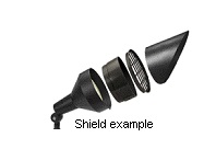
“Shielding” means a barrier around or within a fixture that helps conceal the lamp and control light distribution. A fixture that is “fully shielded” incorporates a solid barrier, emits no light rays above the horizontal plane and effectively obscures visibility of the lamp. A fixture that is “partially shielded” may allow some light to pass through a semi-translucent barrier, and/or may allow visibility of the lamp from certain perspectives.
“Temporary Lighting” means lighting that is intended to be used for a special event for up to seven days.
23.030 Applicability.
- New Outdoor Lighting. All outdoor lighting fixtures installed after the effective date of this chapter shall conform to the requirements established by this chapter.
- Existing Outdoor Lighting. All existing outdoor lighting fixtures installed prior to the effective date of this chapter shall be addressed as follows:
- To address nuisances caused by improperly installed, unshielded, or misdirected fixtures, it is recommended that all existing outdoor lighting fixtures be adjusted or modified to the extent practical to reduce or eliminate glare, light trespass, and light pollution.
- All existing outdoor lighting fixtures located on a property that is part of an application for Design Review approval; a Conditional Use Permit; subdivision approval; or, a building permit for any new structure, or new or modified exterior light fixtures, or any addition(s) of gross floor area, seating capacity, or parking spaces (either with a single addition or cumulative additions), shall meet the requirements of this chapter for the entire property. Such applications are required to include an outdoor lighting plan pursuant to section 23.060. Conformity shall occur prior to final inspection, final plat recordation, or business license issuance, when applicable.
23.040 Exemptions.
- The following are exempt from the provisions of this chapter:
- Seasonal displays using multiple low-wattage bulbs (approximately 15 lumens or less), provided that they do not constitute a fire hazard, create a nuisance, and are maintained in a safe and attractive condition.
- Vehicular lights and all temporary emergency lighting needed by the law enforcement and Fire Protection District, or other emergency services.
- All temporary lighting used for the construction or repair of roadways, utilities, and other public infrastructure.
- All lighting required by state or federal regulatory agencies.
- Illuminated address at no more than 15 lumens.
- The Community Development director may authorize minor deviations when proposed outdoor lighting does not conflict with the purposes of this chapter. An application for such a deviation must be made in writing and include an outdoor lighting plan pursuant to sections 23.050 G and 23.06O. Temporary lighting for special events shall be reviewed in this manner.
23.050 General Requirements.
The following general standards apply to all non-exempt outdoor lighting fixtures:
- Nuisance prevention. All outdoor lighting fixtures shall be designed, located, installed, aimed downward or toward structures, retrofitted if necessary, and maintained in order to prevent glare, light trespass, and light pollution.
- Maintenance. Fixtures and lighting systems shall be in good working order and maintained in a manner that serves the original design intent of the system.
- Lighting Levels. Outdoor lighting installations shall be designed to avoid harsh contrasts in lighting levels between the project site and the adjacent properties. The Mono County Planning Commission may, by resolution, adopt standards for maximum or minimum lighting levels for various land use areas and for public streets, sidewalks, or trails, as developed by the Community Development and Public Works departments.
- Lamp Types. Metal halide or high-pressure sodium lamps are preferred for all new commercial and industrial area lighting (parking lot and yard lights) and street lighting due to good color rendering and good energy efficiency, and LEDs are preferred for energy efficiency. Low-pressure sodium lamps and mercury vapor lamps are not permitted. LEDs or compact fluorescent lamps are preferred for residential lighting.
- Fixture Types. All new outdoor lighting shall use full cutoff luminaires with the light source downcast and fully shielded with no light emitted above the horizontal plane, with the following exceptions:
- Fixtures that have a maximum output of 100 lumens (equivalent to one 10-watt incandescent bulb) or less, regardless of the number of bulbs, may be left unshielded provided the bulb surfaces are obscured from off-site visibility with a semi-translucent or frosted glass that has an opaque top to prevent the light from shining directly up. However, partial or full shielding is preferred to control light output in all situations.
- Fixtures that have a maximum output of 600 lumens (equivalent to one 40-watt incandescent bulb) or less shall be partially or totally shielded using a solid or semi-translucent barrier, provided that the lamp is not visible from off site, no direct glare is produced, and the fixture has an opaque top to keep light from shining directly up; e.g., a low output-style wall pack.
- Floodlights that do not meet the definition of “full cutoff” may be used if permanently directed downward, if no light is projected above the horizontal plane, and if and fitted with external shielding to prevent glare and off-site light trespass. Unshielded floodlights are prohibited.
Glare from unshielded floodlight
Shielding prevents glare
- Accent Lighting. Residential accent lighting shall be limited. LED-type accent lighting is preferred. Commercial accent lighting may be permitted in conjunction with a use permit. Limited architectural features may be illuminated by uplighting, provided that the light is effectively contained by the structure, the lamps are low intensity to produce a subtle lighting effect, and no glare or light trespass is produced. For statues, public art, or other objects of interest that cannot be illuminated with down-lighting, upward lighting may be used only in the form of one narrow-cone spotlight that confines the illumination to the object of interest.
- The provisions of this chapter are not intended to prevent the use of any design, material, or method of installation or operation not specifically prescribed herein, provided that the Community Development director has approved any such alternative. An alternative proposal may be approved if it provides at least approximate equivalence to the applicable specific requirements of this chapter, or if it is otherwise satisfactory and complies with the intent of this chapter.
- Mono County reserves the right to further restrict outdoor lighting including, but not limited to, pole height and level of illumination, when it is deemed in the public interest consistent with the purpose of this chapter.
23.060 Outdoor Lighting Plans.
- An outdoor lighting plan shall be submitted in conjunction with an application for design review approval; a Conditional Use Permit; subdivision approval; or, a building permit for any new structure, or new or modified exterior light fixtures, or any addition(s) of gross floor area, seating capacity, or parking spaces (either with a single addition or cumulative additions). An outdoor lighting plan is required for all new outdoor lighting installations on commercial (includes multifamily residential project of four or more units), industrial, public and institutional properties. The Community Development director may request outdoor lighting plans from applicants for other types of projects due to project location, size, or proposed use, as necessary. An outdoor lighting plan shall include at least the following:
- Manufacturer specification sheets, cut-sheets, or other manufacturer-provided information for all proposed outdoor lighting fixtures to show fixture diagrams and light output levels;
- The proposed location, mounting height, and aiming point of all outdoor lighting fixtures (a site plan is preferred); and
- If building elevations are proposed for illumination, drawings for all relevant building elevations showing the fixtures, the portions of the elevations to be illuminated, the illuminance level of the elevations, and the aiming point for any remote light fixture.
- If needed to review the proposed outdoor lighting fixture installation, the Community Development director may require additional information following the initial outdoor lighting plan submittal, including but not limited to a written narrative to demonstrate the objectives of the lighting, Photometric data, Color Rendering Index (CRI) of all lamps and other descriptive information on the fixtures, computer-generated photometric grid showing footcandle readings every 10 feet within the property or site and 10 feet beyond the property lines (an iso-footcandle contour line-style plan may be acceptable), and/or landscaping information to describe potential screening.

Example of a narrow-cone spotlight
- The Community Development director may approve, deny, or require modifications to any outdoor lighting plan in order to meet the purpose of this chapter.
23.070 Prohibitions.
- The installation of any new fixture not in conformance to this chapter is prohibited.
- No outdoor lighting fixtures shall be installed, aimed, or directed to produce light that spills over into neighboring properties or the public right of way. Light trespass is prohibited.
- No outdoor lighting fixture may be installed or maintained in such a manner to cause glare visible from off site.
- No outdoor lighting fixture may be operated in such a manner as to constitute a hazard or danger to persons, or to safe vehicular travel.
- Blinking, flashing, moving, revolving, scintillating, flickering, changing-intensity, and changing-color lights and internally illuminated signs are prohibited.
- The installation of new mercury vapor and/or low-pressure sodium lamps is prohibited.
- Search lights, laser source lights, or any similar high-intensity light is prohibited except in emergencies by police and fire personnel or at their direction, or for approved temporary lighting.
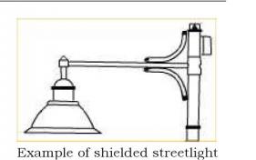
- Streetlights shall be down directed with complete horizontal shielding of the reflective surface and no higher than 17 feet from the bottom of the shielded fixture surface with a maximum 150-watt lamp. Greater height may be granted by the Community Development director for safety or adopted minimum highway standards.
23.080 Signs.
All outdoor lighting for commercial signs installed and maintained pursuant to Chapter 07 shall conform to the provisions of this chapter. Light bulbs or lighting tubes used for sign illumination shall not be readily visible from the vehicular travel lanes, adjacent public rights of way, or adjoining properties. The intensity of sign lighting shall not exceed that necessary to illuminate and make legible a sign from the approved location of view, such as pedestrian walkway, adjacent travel way or closest County street.
23.090 Outdoor Performance, Sport and Recreation Facilities.
- Where playing fields or other special activity areas are to be illuminated, lighting fixtures shall be mounted, aimed, and shielded so that their beams fall within the primary playing area and immediate surroundings, and so that no significant off-site light trespass is produced.
- The main lighting shall be turned off as soon as possible following the end of an event. Where feasible, a low-level lighting system shall be used to facilitate patrons leaving the facility, cleanup, nighttime maintenance, and other closing activities.
23.100 Energy Conservation Measures.
Incorrect installations, poor choice of fixtures, and over-lighting can result in unnecessarily high energy costs. The following recommendations are intended to encourage the efficient use of energy for lighting purposes:
- All non-essential outdoor commercial and residential lighting shall be turned off after business hours and/or when not in use. Limited accent lighting and safety lighting as approved by the Community Development director may remain illuminated after business hours.
- Where practical, outdoor lighting installations are encouraged to include timers, dimmers, or photocell controllers that turn lights off during daylight hours to reduce overall energy consumption and eliminate unnecessary lighting.
- When selecting new outdoor lighting, the full cost of operation over the life of the fixture(s) should be considered. Substantial annual energy savings may be realized by using quality efficient fixtures.
- Indiscriminate and excessive lighting shall be avoided. Light should be directed only to where it is needed with appropriate intensity.
23.110 Violations and Penalties.
It shall be unlawful to install or operate any outdoor lighting fixture in violation of this chapter. Any person violating any provisions of this chapter may be subject to the provisions of Mono County Code section 1.04.060. In addition, any outdoor lighting fixture erected or maintained contrary to the provisions of this chapter may be declared to be a public nuisance subject to the procedures set forth in County Code Chapter 07.20. Such remedies are in addition to and may be sought or imposed concurrently with any other remedy provided by law, regulation or ordinance.
23.120 Figures and Diagrams.
The following figures illustrate examples of acceptable and unacceptable types of outdoor lighting fixtures. Note that even those types of fixtures shown as “acceptable” must be installed and aimed properly to comply with this chapter.
23.130 Repeals.
This chapter supersedes and takes precedence over any other code sections that are inconsistent with these regulations.
FIGURE 14: EXAMPLES OF LIGHTING FIXTURES